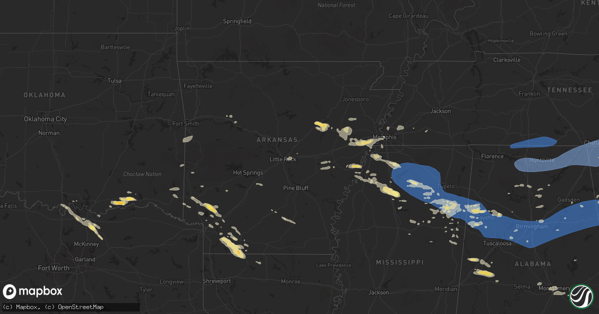
Hail Map in Arkansas on June 7, 2025
Get this storm
June 7 map
$229
one time, instant access
Download today. No call, no setup
Keep the $229
Bought the map and want the full workflow? Apply the entire $229 to a subscription within 7 days. None of it is wasted.
Every map, not just this one
This buys you this map. Subscription and you get every map we run, in the markets you choose from a few cities to whole states to nationwide. Plus real-time alerts the moment a storm fires.
Contact data
Name, contact info, occupancy, even credit band for addresses in the footprint. You go from where it hit to who to call.
Become the source they trust
Unlimited branding weather history reports on demand. You already have the documented answer ready for the property owner, and you are the one who showed up with it.
Property data and RoofTrace estimates
Pull up any address you have got, its value and the exact code rules for that jurisdiction, straight from One Click Code. Then RoofTrace estimates the squares, pitch, and roof value, priced the way you price.
Storm reports in Arkansas
Arkansas
| Date | Description |
|---|---|
| 06/07/202510:25 AM CDT | Reported downed trees and tree on home at the 300 block of waverly rd in helena... Ar. Time estimated on radar. |
| 06/07/20259:46 AM CDT | Trees reported blown down. |
| 06/07/20259:17 AM CDT | Tree down at the intersection of orange and quapaw with power lines down and blocking orange street in hot springs. |
| 06/07/20259:14 AM CDT | Several reports of large limbs down in sherwood. |
| 06/07/20259:07 AM CDT | Multiple trees reported down near hickory plains. |
| 06/07/20259:02 AM CDT | Tree down on old stagecoach road in southwestern little rock. |
| 06/07/20258:58 AM CDT | Powerlines down via social media picture in the community of judsonia. |
| 06/07/20258:56 AM CDT | Large tree across road on n 15th st. & cedar st. Near the library. Time estimated. |
| 06/07/20258:32 AM CDT | Numerous trees down across cleburne county with several blocking roads. |
| 06/07/20258:14 AM CDT | A large tree limb fell through a home near this location near rover. No injuries reported. |
| 06/07/20258:13 AM CDT | Multiple trees reported blown down in the community of rover. |
| 06/07/20257:41 AM CDT | Local police dispatch reported several trees down along arkansas highway 80 east of waldron. |
| 06/07/20257:32 AM CDT | Multiple trees reported down along ar-highway 7 near the pope/newton county line. |
| 06/07/20257:17 AM CDT | Numerous trees reported down across the county with portions of arkansas highway 7 blocked with downed trees. |
| 06/07/20257:11 AM CDT | Numerous trees reported down in the clarksville area with multiple trees blocking arkansas highway 164. |
| 06/07/202512:52 AM CDT | Reports of a tree down in lewisville. |
| 06/06/202510:38 PM CDT | Reports of trees and powerlines down all over the town of hope. |
| 06/06/202510:06 PM CDT | Reports of trees and powerlines down. |
| 06/06/20259:35 PM CDT | Reports of trees down in the mineral springs area with at least one report on north pine street in town. |
| 06/06/20258:54 PM CDT | Report of trees down near us 371 and liggin drive east of lockesburg. |
All States Impacted by Hail Map on June 7, 2025
Cities Impacted by Hail Map on June 7, 2025
- Bradford, AR
- Bald Knob, AR
- Russell, AR
- Hackett, AR
- Cameron, OK
- White Deer, TX
- Augusta, AR
- Clarksville, AR
- Heavener, OK
- Huntington, AR
- Hartford, AR
- Greenwood, AR
- Midland, AR
- Lamar, AR
- Groom, TX
- Knoxville, AR
- London, AR
- McCrory, AR
- Mena, AR
- Hatfield, AR
- Hickory Ridge, AR
- Wynne, AR
- Pampa, TX
- Colt, AR
- Fisher, AR
- Harrisburg, AR
- Cherry Valley, AR
- Lonoke, AR
- Scott, AR
- North Little Rock, AR
- Memphis, TN
- Millington, TN
- Walls, MS
- Horn Lake, MS
- Arlington, TN
- Bolivar, TN
- Whiteville, TN
- Houlka, MS
- Pontotoc, MS
- Randolph, MS
- Oxford, MS
- Thaxton, MS
- Houston, MS
- Okolona, MS
- Aberdeen, MS
- Prairie, MS
- Sulligent, AL
- Amory, MS
- Senatobia, MS
- Coldwater, MS
- Holly Springs, MS
- Sardis, MS
- Como, MS
- Waterford, MS
- Abbeville, MS
- Potts Camp, MS
- Hickory Flat, MS
- Batesville, MS
- Myrtle, MS
- New Albany, MS
- Blue Mountain, MS
- Blue Springs, MS
- Guntown, MS
- Etta, MS
- Ecru, MS
- Shannon, MS
- Belden, MS
- University, MS
- Taylor, MS
- Tupelo, MS
- Paris, MS
- Banner, MS
- Vardaman, MS
- Water Valley, MS
- Bruce, MS
- Pittsboro, MS
- Nettleton, MS
- Smithville, MS
- Plantersville, MS
- Greenwood Springs, MS
- Gattman, MS
- Detroit, AL
- Caledonia, MS
- Hamilton, MS
- Beaverton, AL
- Columbus, MS
- Guin, AL
- Vernon, AL
- Millport, AL
- West Point, MS
- Kilmichael, MS
- Winfield, AL
- Fayette, AL
- Reform, AL
- Kennedy, AL
- Steens, MS
- Bankston, AL
- Carbon Hill, AL
- Berry, AL
- Gordo, AL
- Northport, AL
- Elrod, AL
- Echola, AL
- Double Springs, AL
- Addison, AL
- Houston, AL
- Vinemont, AL
- Parrish, AL
- Oakman, AL
- Cullman, AL
- Blountsville, AL
- Hayden, AL
- Guntersville, AL
- Hanceville, AL
- Cordova, AL
- Townley, AL
- Tanner, AL
- Athens, AL
- Decatur, AL
- Hillsboro, AL
- Trinity, AL
- Madison, AL
- Huntsville, AL
- Harvest, AL
- Laceys Spring, AL
- Somerville, AL
- Union Grove, AL
- Valhermoso Springs, AL
- Anderson, AL
- Lester, AL
- Minor Hill, TN
- Lexington, AL
- Five Points, TN
- Taft, TN
- Ardmore, TN
- Fayetteville, TN
- Prospect, TN
- Dellrose, TN
- Elkmont, AL
- Toney, AL
- Hazel Green, AL
- Ardmore, AL
- Trafford, AL
- Remlap, AL
- Locust Fork, AL
- Bessemer, AL
- Adger, AL
- Holly Pond, AL
- Quinton, AL
- Coker, AL
- Buhl, AL
- McCalla, AL
- Brookwood, AL
- Tuscaloosa, AL
- Woodstock, AL
- Vance, AL
- West Blocton, AL
- Cottondale, AL
- Pleasant Grove, AL
- Adamsville, AL
- Birmingham, AL
- Docena, AL
- Dolomite, AL
- Mulga, AL
- Fairfield, AL
- Mount Olive, AL
- Fultondale, AL
- Graysville, AL
- Elora, TN
- Flintville, TN
- Kelso, TN
- Huntland, TN
- New Market, AL
- Cleveland, AL
- Oneonta, AL
- Owens Cross Roads, AL
- Gurley, AL
- Paint Rock, AL
- Woodville, AL
- New Hope, AL
- Brownsboro, AL
- Grant, AL
- Scottsboro, AL
- Leeds, AL
- Moody, AL
- Trussville, AL
- Montevallo, AL
- Brierfield, AL
- Columbiana, AL
- Sterrett, AL
- Alabaster, AL
- Chelsea, AL
- Vandiver, AL
- Pelham, AL
- Calera, AL
- Wilsonville, AL
- Pell City, AL
- Helena, AL
- Hollywood, AL
- Dutton, AL
- Harpersville, AL
- Vincent, AL
- Ohatchee, AL
- Raton, NM
- Gadsden, AL
- Cedartown, GA
- Talladega, AL
- Lincoln, AL
- Chickamauga, GA
- Jacksonville, AL
- Piedmont, AL
- Valley Head, AL
- Mentone, AL
- Henagar, AL
- Pisgah, AL
- Menlo, GA
- Guild, TN
- Chattanooga, TN
- Trenton, GA
- Wildwood, GA
- Ider, AL
- Bryant, AL
- Flat Rock, AL
- Stevenson, AL
- Higdon, AL
- Whitwell, TN
- Lookout Mountain, GA
- Rising Fawn, GA
- South Pittsburg, TN
- Fackler, AL
- Jasper, TN
- Bridgeport, AL
- Trenton, AL
- Hollytree, AL
- Cave Spring, GA
- Engelhard, NC
- La Fayette, GA
- Hixson, TN
- Rossville, GA
- Lookout Mountain, TN
- Flintstone, GA
- Whiteside, TN
- Lupton City, TN
- Rock Spring, GA
- Ringgold, GA
- Fort Oglethorpe, GA
- Trion, GA
- Eastaboga, AL
- Riverside, AL
- Bowdon, GA
- Ranburne, AL
- Alpine, AL
- Tallapoosa, GA
- Waco, GA
- Bremen, GA
- Oxford, AL
- Carrollton, GA
- Delta, AL
- Heflin, AL
- Childersburg, AL
- Munford, AL
- Muscadine, AL
- Cropwell, AL
- Anniston, AL
- Rockmart, GA
- Weaver, AL
- Ragland, AL
- Buchanan, GA
- Alexandria, AL
- Fruithurst, AL
- Odenville, AL
- Wellington, AL
- Ashville, AL
- Springville, AL
- Lineville, AL
- Jonesboro, GA
- Jamestown, ND
- Ooltewah, TN
- Harrison, TN
- McDonald, TN
- Dalton, GA
- Tunnel Hill, GA
- Apison, TN
- Cohutta, GA
- Cleveland, TN
- Temple, GA
- Dallas, GA
- Villa Rica, GA
- Courtenay, ND
- Wimbledon, ND
- Des Moines, NM
- Capulin, NM
- Stockbridge, GA
- Hiram, GA
- Douglasville, GA
- Powder Springs, GA
- Whitesburg, GA
- Winston, GA
- Cove City, NC
- Trenton, NC
- Cooperstown, ND
- Finley, ND
- Sharon, ND
- Spiritwood, ND
- Jasper, GA
- Ranger, GA
- Talking Rock, GA
- Palmetto, GA
- New Bern, NC
- Hope, ND
- Portland, ND
- Edgeley, ND
- Smyrna, GA
- Grantsboro, NC
- Austell, GA
- Clarkdale, GA
- Maple Hill, NC
- Mableton, GA
- Burgaw, NC
- Marietta, GA
- Duluth, GA
- Willard, NC
- Loganville, GA
- Lilburn, GA
- Snellville, GA
- Marathon, TX
- Grenville, NM
- Lawrenceville, GA
- Suwanee, GA
- Creswell, NC
- Eatonton, GA
- Sparta, GA
- Rocky Point, NC
- Hillsboro, ND
- Shelly, MN
- Caledonia, ND
- Halstad, MN
- Ada, MN
- Clayton, NM
- Wrens, GA
- Avera, GA
- Louisville, GA
- Stapleton, GA
- Springer, NM
- Lula, GA
- Baldwin, GA
- Homer, GA
- Cornelia, GA
- Alto, GA
- Demorest, GA
- Mount Airy, GA
- Maysville, GA
- Gillsville, GA
- Cleveland, GA
- Eastanollee, GA
- Toccoa, GA
- Westminster, SC
- Martin, GA
- Carnesville, GA
- Seneca, SC
- Townville, SC
- Canon, GA
- Anderson, SC
- Lavonia, GA
- Bowersville, GA
- Hartwell, GA
- Fair Play, SC
- Liberty, SC
- Central, SC
- Clemson, SC
- Pendleton, SC
- Six Mile, SC
- Norris, SC
- Piedmont, SC
- Pelzer, SC
- Belton, SC
- Williamston, SC
- Easley, SC
- Keysville, GA
- Pickens, SC
- Greenville, SC
- Simpsonville, SC
- Honea Path, SC
- Ware Shoals, SC
- Fountain Inn, SC
- Sedan, NM
- Stuttgart, AR
- Ludowici, GA
- Waynesboro, GA
- Taylors, SC
- Gray Court, SC
- Mauldin, SC
- Greer, SC
- Laurens, SC
- De Soto, MO
- Pinecrest, CA
- Hinesville, GA
- Fletcher, MO
- Umpire, AR
- Dierks, AR
- Delight, AR
- Broken Bow, OK
- Glennville, GA
- Dittmer, MO
- Richwoods, MO
- Gladstone, NM
- De Valls Bluff, AR
- Roe, AR
- Holly Grove, AR
- Clarendon, AR
- Valmeyer, IL
- Fort Stewart, GA
- Waterloo, IL
- Fults, IL
- Amistad, NM
- Malvern, AR
- Woodruff, SC
- Hernando, MS
- Lexa, AR
- Marianna, AR
- Tunica, MS
- Robinsonville, MS
- Lake Cormorant, MS
- West Helena, AR
- Poplar Grove, AR
- Long Barn, CA
- Prattsville, AR
- Lexington, SC
- West Columbia, SC
- Saluda, SC
- Gilbert, SC
- Leesville, SC
- Chapin, SC
- Prosperity, SC
- Newberry, SC
- Silverstreet, SC
- Cayce, SC
- Pomaria, SC
- Little Mountain, SC
- Columbia, SC
- Batesburg, SC
- Gaston, SC
- Blythewood, SC
- Winnsboro, SC
- Jenkinsville, SC
- Irmo, SC
- Ridgeway, SC
- Mosquero, NM
- De Queen, AR
- Elgin, SC
- Lugoff, SC
- Hopkins, SC
- Lockesburg, AR
- Widener, AR
- Forrest City, AR
- Sledge, MS
- Heth, AR
- Dundee, MS
- Madison, AR
- Maxwell, NM
- Varnville, SC
- Estill, SC
- Pineland, SC
- Nara Visa, NM
- Crenshaw, MS
- Proctor, AR
- Hughes, AR
- Dalhart, TX
- Channing, TX
- Adrian, TX
- Marion, AR
- West Memphis, AR
- Nashville, AR
- Mineral Springs, AR
- Edmondson, AR
- Eagletown, OK
- Ozan, AR
- Columbus, AR
- Washington, AR
- Somerville, TN
- Vega, TX
- Fulton, AR
- Marietta, OK
- Coahoma, MS
- Helena, AR
- Rule, TX
- Stamford, TX
- Haskell, TX
- Hope, AR
- Marks, MS
- Whitesboro, TX
- Winthrop, AR
- Kingston, OK
- Lebanon, OK
- Fordyce, AR
- Avoca, TX
- Buckner, AR
- Rosston, AR
- Emmet, AR
- Albany, TX
- Lueders, TX
- Sadler, TX
- Courtland, MS
- Enid, MS
- Pope, MS
- Sherman, TX
- Waldo, AR
- Wilton, AR
- Ashdown, AR
- Oakland, MS
- Coffeeville, MS
- Banks, AR
- Warren, AR
- Thornton, AR
- Howe, TX
- Throckmorton, TX
- Horatio, AR
- McNeil, AR
- Hillsboro, GA
- Texarkana, AR
- Whitewright, TX
- Tom Bean, TX
- Bells, TX
- Newcastle, TX
- Moran, TX
- Van Alstyne, TX
- Lewisville, AR
- Baird, TX
- Trenton, TX
- Blue Ridge, TX
- Leonard, TX
- Stamps, AR
- Anna, TX
- Magnolia, AR
- Logan, NM
- Hartley, TX
- Taylor, AR
- Celeste, TX
- Emerson, AR
- Woodland, MS
- Shongaloo, LA
- Pottsboro, TX
- Haynesville, LA
- Stinnett, TX
- Tillatoba, MS
- Cedarbluff, MS
- Maben, MS
- Amarillo, TX
- Wildorado, TX
- Pheba, MS
- Mantee, MS
- Canyon, TX
- Lisbon, LA
- Eupora, MS
- Bellefontaine, MS
- Bernice, LA
- Happy, TX
- Crawford, MS
- Starkville, MS
- Hendrix, OK
- Ravenna, TX
- Hereford, TX
- Bennington, OK
- Wayside, TX
- Tulia, TX
- Claude, TX
- Silverton, TX
- Boswell, OK
- Reliance, TN
- Brooksville, MS
- Macon, MS
- Aliceville, AL
- Hugo, OK
- Boligee, AL
- Autaugaville, AL
- Prattville, AL
- Eutaw, AL
- Stewart, MS
- Soper, OK
- Alexander City, AL
- Jacksons Gap, AL
- Livingston, AL
- Forkland, AL
- Akron, AL
- Sawyerville, AL
- Louisville, MS
- Montgomery, AL
- Greensboro, AL
- Stone Mountain, GA
- Abernathy, TX
- Emporia, VA
- Idalou, TX
- Gallion, AL
- Floydada, TX
- Jarratt, VA
- Freeman, VA
- Newbern, AL
- Uniontown, AL
- Faunsdale, AL
- Drewryville, VA
- Capron, VA
- Pike Road, AL
- Crosbyton, TX
- Lorenzo, TX
- Ralls, TX
- Spur, TX
- Post, TX
- Mathews, AL
- Lithonia, GA
- Saratoga, AR
- Seymour, TX
- Knox City, TX
- Ellenwood, GA
- Decatur, GA
- Monroe, GA
- Covington, GA
- O'Brien, TX
- Snyder, TX
- Fitzpatrick, AL
- Justiceburg, TX
- Girard, TX
- Weinert, TX


