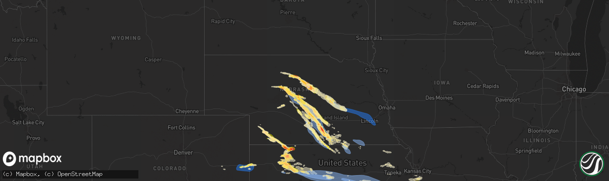
Hail Map in Nebraska on June 7, 2024
The weather event in Nebraska on June 7, 2024 includes Wind and Hail maps. 14 states and 513 cities were impacted and suffered possible damage. The total estimated number of properties impacted is 18,679.
Want more than just the map?
Turn this storm into a full workflow.
- Owner + property data so you know who to knock
- OnDemand branded weather history reports to win the "did we even have hail?" argument
- RoofTrace estimate so reps stop guessing numbers at the door
Bought this map? Upgrade within 7 days and we'll credit the $230. (10-15 min setup call)
Wind
Hail
18,679
Estimated number of impacted properties by a 1.00" hail or larger6,542
Estimated number of impacted properties by a 1.75" hail or larger502
Estimated number of impacted properties by a 2.50" hail or largerStorm reports in Nebraska
Nebraska
| Date | Description |
|---|---|
| 06/07/20246:53 PM CDT | Report via x from approx 9 nnw central city of a couple pivots tipped over and power outages in the area. Time est from radar. |
| 06/07/20246:51 PM CDT | Report from mping: 3-inch tree limbs broken; power poles broken. |
| 06/07/20246:48 PM CDT | On going. |
| 06/07/20246:37 PM CDT | Delayed damage report from extreme northwestern nance county. Emailed photos depict significant tree damage and a few flipped irrigation pivots in the area. Time based |
| 06/07/20246:30 PM CDT | Mostly dime size with some quarter size. |
| 06/07/20246:30 PM CDT | Pea sized hail... Torrential rainfall and winds estimated 50-60mph |
| 06/07/20246:20 PM CDT | Tree branches down 4 inch diameter. |
| 06/07/20246:12 PM CDT | A local report indicates 1.00 inch wind near Greeley |
| 06/07/20246:05 PM CDT | Corrects time of previous tstm wnd dmg report from greeley. Report from mping: 3-inch tree limbs broken; power poles broken. |
| 06/07/20246:05 PM CDT | Corrects time of previous tstm wnd dmg report from greeley. Tree branches down 4 inch diameter. |
| 06/07/20245:55 PM CDT | A local report indicates 60 MPH wind near 2 N Broken Bow |
| 06/07/20245:54 PM CDT | A local report indicates 1.00 inch wind near Broken Bow |
| 06/07/20245:50 PM CDT | Report via facebook of tree and pivot damage in the area. Neighbor also sustained grain bin damage... Siding damage... And had a couple trailers pushed a bit from their |
| 06/07/20245:45 PM CDT | Emergency management reported notable power pole... Tree... And pivot damage in this general area. Time est from radar. |
| 06/07/20245:34 PM CDT | A local report indicates 1.00 inch wind near 5 NW Merna |
| 06/07/20245:30 PM CDT | Corrects previous tstm wnd dmg report from burwell. Emergency management reported several pivots blown over in the burwell area. Time estimated from radar. |
| 06/07/20245:30 PM CDT | Corrects previous tstm wnd dmg report from burwell. Emergency management reports trees 1.5 feet in diameter snapped off all in the same direction. Em estimates 75 mph w |
| 06/07/20245:23 PM CDT | 1n trenton dam spotter reports lots of pea sized hail and a few ping pong sized hail stones. 45 mph gusts too. |
| 06/07/20245:20 PM CDT | Emergency management reported several pivots blown over in the burwell area. Time estimated from radar. |
| 06/07/20245:20 PM CDT | Emergency management reports trees 1.5 feet in diameter snapped off all in the same direction. Em estimates 75 mph winds. Time estimated from radar. |
| 06/07/20245:20 PM CDT | Pea to sporadic ping pong ball sized hail. Ground was becoming decently covered by the smaller hail stones. Time is radar estimated. |
| 06/07/20245:15 PM CDT | Picture from em. Hail was larger than quarter sized. |
| 06/07/20245:11 PM CDT | A local report indicates 1.00 inch wind near Burwell |
| 06/07/20245:07 PM CDT | Report from mping: quarter |
| 06/07/20245:05 PM CDT | Trained weather spotter... Former nws employee... 1.0 inch measured hail at 40.2421016... -101.2768365 5:05pm ct. |
| 06/07/20245:00 PM CDT | Dime to quarter sized hail reported over a duration of ten minutes. Time is radar estimated. |
| 06/07/20244:57 PM CDT | A local report indicates 1.25 inch wind near 8 NE Taylor |
| 06/07/20244:55 PM CDT | A local report indicates 1.00 inch wind near Anselmo |
| 06/07/20244:54 PM CDT | A local report indicates 1.75 inch wind near 2 WSW Anselmo |
| 06/07/20244:47 PM CDT | Ongoing hail ranging in size up to golf balls in size. Duration of 15 minutes as of 3:55 pm mt. |
| 06/07/20244:39 PM CDT | A local report indicates 1.75 inch wind near Wauneta |
| 06/07/20244:30 PM CDT | Public report through social media including a picture of hail on a tape measure. |
| 06/07/20244:30 PM CDT | Media partner sent a picture from a viewer with time and location of hail. |
| 06/07/20244:30 PM CDT | Reports of car windows broken out in wauneta. |
| 06/07/20244:30 PM CDT | Report from social media. |
| 06/07/20244:23 PM CDT | Time estimated from radar. Hail was stopping around 430 pm cdt. |
| 06/07/20244:17 PM CDT | A local report indicates 1.00 inch wind near 6 SW Rose |
| 06/07/20243:47 PM CDT | A local report indicates 1.50 inch wind near 9 S Halsey |
| 06/07/20243:08 PM CDT | A local report indicates 1.75 inch wind near 5 SSW Thedford |
| 06/06/202410:39 PM CDT | A local report indicates 65 MPH wind near 2 WSW Fairbury |
| 06/06/20249:45 PM CDT | Wind gusts estimated to be 70 mph on hwy 136 near 300 road caused near zero visibility in blowing dust. Time est from radar and nearby mesonet ob. |
| 06/06/20249:40 PM CDT | A local report indicates 69 MPH wind near 5 WNW Riverton |
| 06/06/20249:40 PM CDT | Photo of hail stones up to and including golf ball size via facebook from 10sw blue hill. |
| 06/06/20249:39 PM CDT | Report from mping: 3-inch tree limbs broken; power poles broken. |
| 06/06/20249:25 PM CDT | Power pole also snapped at this intersection. |
| 06/06/20249:20 PM CDT | A local report indicates 1.00 inch wind near 3 S Hildreth |
| 06/06/20249:20 PM CDT | A local report indicates 66 MPH wind near 7 NNW Bloomington |
| 06/06/20249:15 PM CDT | A local report indicates 1.00 inch wind near Bladen |
| 06/06/20249:14 PM CDT | A local report indicates 59 MPH wind near 5 SSW Hildreth |
| 06/06/20249:12 PM CDT | Report via x of a flipped pivot. Time est from radar and area mesonets. |
| 06/06/20249:11 PM CDT | A local report indicates 58 MPH wind near 7 W Macon |
| 06/06/20249:11 PM CDT | A local report indicates 71 MPH wind near 2 SW Bladen |
| 06/06/20249:08 PM CDT | A local report indicates 58 MPH wind near 2 NNW Inland |
| 06/06/20249:05 PM CDT | A local report indicates 1.75 inch wind near 5 NW Bladen |
| 06/06/20249:03 PM CDT | Corrects previous tstm wnd gst report from 1 e wilcox. |
| 06/06/20249:03 PM CDT | A local report indicates 66 MPH wind near 1 E Wilcox |
| 06/06/20249:03 PM CDT | Report via facebook of tree limbs downed in town. Time est from radar and surrounding mesonet obs. |
| 06/06/20249:00 PM CDT | Photo sent in. |
| 06/06/20248:58 PM CDT | A local report indicates 66 MPH wind near 2 NNW Wilcox |
| 06/06/20248:56 PM CDT | A local report indicates 66 MPH wind near 3 NNW Wilcox |
| 06/06/20248:56 PM CDT | Est time from radar. |
| 06/06/20248:55 PM CDT | Report via facebook of damaged and snapped power poles on 731 road between t and w roads. Power was out until approx 330am. Time est from radar and surrounding mesonets |
| 06/06/20248:50 PM CDT | Corrects time and details of previous tstm wnd dmg report from 4 n funk. Emergency manage reported a swath of pivot damage running approx from 740 and s road to 731 and |
| 06/06/20248:50 PM CDT | Report via facebook of isolated tree damage in holdrege... A few limbs were larger in diameter. |
| 06/06/20248:41 PM CDT | Public report of baseball size hail north of norman. Time estimated from radar. |
| 06/06/20248:39 PM CDT | Trained spotter reports golf ball size hail. |
| 06/06/20248:36 PM CDT | A local report indicates 60 MPH wind near 5 NNW Holdrege |
| 06/06/20248:35 PM CDT | Corrects time of previous hail report from 3 wnw norman. Photo sent in. |
| 06/06/20248:35 PM CDT | Photo of hail up to 2 inches in diameter via facebook. Time est from radar. |
| 06/06/20248:34 PM CDT | A local report indicates 66 MPH wind near 8 S Elm Creek |
| 06/06/20248:33 PM CDT | Corrects time of previous hail report from 3 e minden. Trained spotter reports golf ball size hail. |
| 06/06/20248:31 PM CDT | Report from mping: hen egg |
| 06/06/20248:31 PM CDT | Time from radar. |
| 06/06/20248:30 PM CDT | Photo sent in. |
| 06/06/20248:27 PM CDT | A local report indicates 64 MPH wind near 5 NE Garland |
| 06/06/20248:25 PM CDT | A video sent in showing two miles of down powerlines snapped in half. |
| 06/06/20248:20 PM CDT | A barn destroyed with at least 20 pivots turned in the area and several snapped transmission poles for several blocks. |
| 06/06/20248:19 PM CDT | A local report indicates 58 MPH wind near 2 ESE Overton |
| 06/06/20248:18 PM CDT | Mostly dime with some quarter. |
| 06/06/20248:17 PM CDT | A local report indicates 1.00 inch wind near 5 ENE Riverdale |
| 06/06/20248:14 PM CDT | Storm chaser reports golf ball size hail. |
| 06/06/20248:11 PM CDT | Corrects time of previous tstm wnd gst report from kearney airport. Corrects previous tstm wnd gst report from kearney airport. |
| 06/06/20248:11 PM CDT | A local report indicates 1.00 inch wind near 6 E Riverdale |
| 06/06/20248:10 PM CDT | A large tree at least 2 feet in diameter split in two based on public image. |
| 06/06/20248:10 PM CDT | Several 6-7 inch tree limbs down. |
| 06/06/20248:10 PM CDT | Corrects time of previous tstm wnd dmg report from 1 se kearney. Report from mping: 3-inch tree limbs broken; power poles broken. |
| 06/06/20248:04 PM CDT | Fire dept reports quarter size hail in miller. |
| 06/06/20248:01 PM CDT | Corrects previous tstm wnd gst report from kearney airport. |
| 06/06/20248:01 PM CDT | A local report indicates 59 MPH wind near Kearney Airport |
| 06/06/20248:01 PM CDT | A local report indicates 69 MPH wind near 1 E Odessa |
| 06/06/20248:01 PM CDT | A local report indicates 59 MPH wind near 3 E Riverdale |
| 06/06/20248:00 PM CDT | Report from mping: quarter |
| 06/06/20247:56 PM CDT | Nws employee reports quarter size hail on the west side of shelton. |
| 06/06/20247:48 PM CDT | Half dollar hail and 60 mph near gibbon. |
| 06/06/20247:42 PM CDT | Emergency manager reports quarter size hail north of gibbon. |
| 06/06/20247:15 PM CDT | Corrects size and time of previous penny size hail report from ravenna. |
| 06/06/20247:13 PM CDT | Mesonet reports a gust of 60 mph. |
| 06/06/20247:10 PM CDT | Emergency manager relayed photos of trees down in clarks. |
| 06/06/20247:08 PM CDT | Report from mping: trees uprooted or snapped; roof blown off. |
| 06/06/20247:04 PM CDT | Mesonet reports a gust of 70 mph. |
| 06/06/20247:04 PM CDT | Mostly quarters with some half dollar sized hail. |
| 06/06/20247:01 PM CDT | Estimated 50-60 mph. |
| 06/06/20247:00 PM CDT | Trained spotter estimates 60 mph winds. |
All States Impacted by Hail Map on June 7, 2024
Cities Impacted by Hail Map on June 7, 2024
- Amarillo, TX
- Panhandle, TX
- Canyon, TX
- Claude, TX
- Happy, TX
- Wayside, TX
- Keeseville, NY
- Plattsburgh, NY
- Peru, NY
- Hialeah, FL
- Opa Locka, FL
- Hollywood, FL
- Fort Lauderdale, FL
- Arriba, CO
- Mora, NM
- Mullen, NE
- Buena Vista, NM
- Rainsville, NM
- Pompano Beach, FL
- Boca Raton, FL
- Seneca, NE
- Delray Beach, FL
- Thedford, NE
- Flagler, CO
- Clewiston, FL
- Vergennes, VT
- Lake Worth, FL
- Boynton Beach, FL
- Labelle, FL
- Johnstown, NE
- Elsmere, NE
- Westport, NY
- Imperial, NE
- Bridport, VT
- Ferrisburgh, VT
- Kim, CO
- Springfield, CO
- New Haven, VT
- Starksboro, VT
- Pueblo, CO
- Avondale, CO
- Boone, CO
- Pritchett, CO
- Grenville, NM
- Moore Haven, FL
- Ainsworth, NE
- Long Pine, NE
- Dunning, NE
- Arnold, NE
- Halsey, NE
- Stapleton, NE
- Raton, NM
- Enders, NE
- Two Buttes, CO
- North Platte, NE
- Wauneta, NE
- Las Vegas, NM
- Okeechobee, FL
- Brewster, NE
- Palisade, NE
- Taylor, NE
- Bassett, NE
- Maxwell, NE
- Burwell, NE
- Syracuse, KS
- Fort Pierce, FL
- Anselmo, NE
- Hugoton, KS
- Stratton, NE
- Solano, NM
- Clayton, NM
- Trenton, NE
- Culbertson, NE
- Elyria, NE
- Moscow, KS
- Conchas Dam, NM
- Merna, NE
- Broken Bow, NE
- Trementina, NM
- Ord, NE
- Ericson, NE
- Elkhart, KS
- Goodwell, OK
- McCook, NE
- Oberlin, KS
- Lakin, KS
- Scotia, NE
- Selden, KS
- Ansley, NE
- Felt, OK
- Boise City, OK
- Callaway, NE
- Greeley, NE
- Dresden, KS
- Danbury, NE
- Rexford, KS
- North Loup, NE
- Liberal, KS
- Hoxie, KS
- Burlington, CO
- Bethune, CO
- Garita, NM
- Norcatur, KS
- Hooker, OK
- Jennings, KS
- Mason City, NE
- Wolbach, NE
- Spalding, NE
- Walsh, CO
- Campo, CO
- Keyes, OK
- Kenton, OK
- Dalhart, TX
- Texline, TX
- Sedan, NM
- Texhoma, OK
- Stratford, TX
- Rolla, KS
- Kanorado, KS
- Norton, KS
- Saint Paul, NE
- Palmer, NE
- Cedar Rapids, NE
- Stratton, CO
- Hazard, NE
- Litchfield, NE
- Oconto, NE
- Pleasanton, NE
- Weskan, KS
- Keldron, SD
- Morristown, SD
- Lemmon, SD
- Rigby, ID
- Menan, ID
- Central City, NE
- Fullerton, NE
- Guymon, OK
- Morland, KS
- Clarks, NE
- Ravenna, NE
- Osceola, NE
- Watauga, SD
- Goodland, KS
- Archer, NE
- Clayton, KS
- McIntosh, SD
- Miller, NE
- Sumner, NE
- Amherst, NE
- Stromsburg, NE
- Polk, NE
- Hordville, NE
- Silver Creek, NE
- Gibbon, NE
- McLaughlin, SD
- Penokee, KS
- Shelton, NE
- Lexington, NE
- Eddyville, NE
- Quinter, KS
- Collyer, KS
- Timber Lake, SD
- Hardesty, OK
- Wood River, NE
- Hill City, KS
- Riverdale, NE
- Kearney, NE
- Overton, NE
- Wakeeney, KS
- Bogue, KS
- Isabel, SD
- Elm Creek, NE
- Palco, KS
- Minden, NE
- Bertrand, NE
- Eagle Butte, SD
- Kenesaw, NE
- Loomis, NE
- Park, KS
- Grainfield, KS
- Grinnell, KS
- Heartwell, NE
- Odessa, NE
- Axtell, NE
- Ellis, KS
- Plainville, KS
- Doniphan, NE
- Holdrege, NE
- Juniata, NE
- Ogallah, KS
- Hastings, NE
- Funk, NE
- Hays, KS
- Surprise, NE
- Shelby, NE
- Rising City, NE
- Dwight, NE
- Ulysses, NE
- Valparaiso, NE
- Pleasant Dale, NE
- Bee, NE
- Raymond, NE
- Garland, NE
- Seward, NE
- Gresham, NE
- Staplehurst, NE
- Malcolm, NE
- Perryton, TX
- Bladen, NE
- Holstein, NE
- Campbell, NE
- Roseland, NE
- Catharine, KS
- Natoma, KS
- Victoria, KS
- Upland, NE
- Wilcox, NE
- Hildreth, NE
- Blue Hill, NE
- Naponee, NE
- Bloomington, NE
- Gorham, KS
- Franklin, NE
- Riverton, NE
- Republican City, NE
- Smith Center, KS
- Bennet, NE
- Lincoln, NE
- Walton, NE
- Roca, NE
- Davey, NE
- Ceresco, NE
- Palmyra, NE
- Walker, KS
- Paradise, KS
- Russell, KS
- Bunker Hill, KS
- Dorrance, KS
- Lawrence, NE
- Deweese, NE
- Nelson, NE
- Fairfield, NE
- Sylvan Grove, KS
- Luray, KS
- Lucas, KS
- Glenvil, NE
- Red Cloud, NE
- Waldo, KS
- Wilson, KS
- Edgar, NE
- Guide Rock, NE
- Inavale, NE
- Lebanon, KS
- Superior, NE
- Lincoln, KS
- Lorraine, KS
- Holyrood, KS
- Ellsworth, KS
- Claflin, KS
- Kanopolis, KS
- Beverly, KS
- Esbon, KS
- Oak, NE
- Brookville, KS
- Tescott, KS
- Salina, KS
- Marquette, KS
- Geneseo, KS
- Falun, KS
- Ruskin, NE
- Deshler, NE
- Hardy, NE
- Mankato, KS
- Republic, KS
- Burr Oak, KS
- Byron, NE
- Courtland, KS
- Hebron, NE
- Belleville, KS
- Chester, NE
- Gilead, NE
- Fairbury, NE
- Reynolds, NE
- Morrowville, KS
- Diller, NE
- Endicott, NE
- Steele City, NE
- Hollenberg, KS
- New Cambria, KS
- Lindsborg, KS
- Assaria, KS
- Mcpherson, KS
- Gypsum, KS
- Scandia, KS
- Jewell, KS
- Agenda, KS
- Galva, KS
- Roxbury, KS
- Canton, KS
- Hope, KS
- Solomon, KS
- Abilene, KS
- Tampa, KS
- Durham, KS
- Seneca, KS
- Washington, KS
- Herington, KS
- Lehigh, KS
- Wetmore, KS
- Sabetha, KS
- Goff, KS
- Saint Marys, KS
- Belvue, KS
- Emmett, KS
- Osage City, KS
- White City, KS
- Woodbine, KS
- Delia, KS
- Hillsboro, KS
- Fairview, KS
- Lost Springs, KS
- Ramona, KS
- Lincolnville, KS
- Florence, KS
- Peabody, KS
- Enterprise, KS
- Marion, KS
- Strong City, KS
- Chapman, KS
- Junction City, KS
- Dwight, KS
- Alta Vista, KS
- Elmdale, KS
- Burdick, KS
- Council Grove, KS
- Wilsey, KS
- Cedar Point, KS
- Lyndon, KS
- Mayetta, KS
- Gardner, KS
- Spring Hill, KS
- Bucyrus, KS
- Olathe, KS
- New Century, KS
- Hoyt, KS
- Allen, KS
- Quenemo, KS
- Burns, KS
- Emporia, KS
- Matfield Green, KS
- Cottonwood Falls, KS
- Olpe, KS
- Americus, KS
- Reading, KS
- Alma, KS
- Admire, KS
- Stilwell, KS
- Cleveland, MO
- Belton, MO
- Peculiar, MO
- Freeman, MO
- Topeka, KS
- Newton, KS
- Pomona, KS
- Meriden, KS
- Lebo, KS
- Melvern, KS
- Overland Park, KS
- Princeton, KS
- Ottawa, KS
- Hartford, KS
- Madison, KS
- Neosho Rapids, KS
- Burlington, KS
- Rantoul, KS
- Elbing, KS
- Greeley, KS
- Louisburg, KS
- Waverly, KS
- Leawood, KS
- Kansas City, MO
- Harrisonville, MO
- Osawatomie, KS
- Fontana, KS
- Grandview, MO
- Lees Summit, MO
- Westphalia, KS
- Le Roy, KS
- Mayhill, NM
- Richmond, KS
- Garnett, KS
- Williamsburg, KS
- Raymore, MO
- Colony, KS
- Welda, KS
- Kincaid, KS
- Parker, KS
- Lane, KS
- Whitehorse, SD
- Piqua, KS
- Bronson, KS
- Moran, KS
- Iola, KS
- La Harpe, KS
- Humboldt, KS
- Neosho Falls, KS
- Yates Center, KS
- Savonburg, KS
- Elsmore, KS
- Chanute, KS
- Erie, KS
- Mindenmines, MO
- Liberal, MO
- Uniontown, KS
- Redfield, KS
- Richards, MO
- Torrington, WY
- McCune, KS
- Stark, KS
- Sheldon, MO
- Lamar, MO
- Stockton, MO
- Jerico Springs, MO
- El Dorado Springs, MO
- Jasper, MO
- Arcola, MO
- Everton, MO
- Walnut Grove, MO
- Lockwood, MO
- Ash Grove, MO
- Golden City, MO
- Pleasant Hill, MO
- Carthage, MO
- Marionville, MO
- Republic, MO
- Bois D Arc, MO
- La Russell, MO
- Miller, MO
- South Greenfield, MO
- Greenfield, MO
- Willard, MO
- Stotts City, MO
- Mount Vernon, MO
- Rogersville, MO
- Ozark, MO
- Billings, MO
- Chadwick, MO
- Richfield, KS
- Walnut Shade, MO
- Reeds Spring, MO
- Highlandville, MO
- Crane, MO
- Galena, MO
- Garrison, MO
- Forsyth, MO
- Buffalo, OK
- Taneyville, MO
- Bradleyville, MO
- Oldfield, MO
- Ava, MO
- Rockaway Beach, MO
- Branson, MO
- Kissee Mills, MO
- Thornfield, MO
- Ridgedale, MO
- Hollister, MO
- Alpena, AR
- Fayetteville, AR
- Byers, CO
- Strasburg, CO
- Deer Trail, CO
- Agate, CO
- Limon, CO
- Fleming, CO
- Haxtun, CO
- Paoli, CO
- Holyoke, CO
- Wray, CO
- Yuma, CO
- Sterling, CO
- Atwood, CO
- Tyrone, OK
- Turpin, OK
- Kismet, KS
- Moundridge, KS
- Goessel, KS
- Walton, KS
- Eskridge, KS
- Marysville, KS
- Home, KS
- Valley Falls, KS
- Nortonville, KS
- Atchison, KS
- Winchester, KS
- Easton, KS
- Platte City, MO
- Leavenworth, KS
- Oskaloosa, KS
- Fort Leavenworth, KS
- Lansing, KS
- Waldron, MO
- Farley, MO
- McLouth, KS
- Kansas City, KS
- Lawrence, KS
- Tonganoxie, KS
- Basehor, KS
- Linwood, KS
- Ozawkie, KS
- De Soto, KS
- Bonner Springs, KS
- Riverside, MO
- Shawnee, KS


