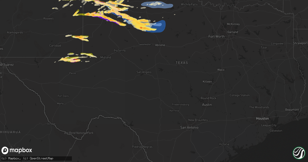
Hail Map in Texas on June 6, 2025
Get this storm
June 6 map
$229
one time, instant access
Download today. No call, no setup
Keep the $229
Bought the map and want the full workflow? Apply the entire $229 to a subscription within 7 days. None of it is wasted.
Every map, not just this one
This buys you this map. Subscription and you get every map we run, in the markets you choose from a few cities to whole states to nationwide. Plus real-time alerts the moment a storm fires.
Contact data
Name, contact info, occupancy, even credit band for addresses in the footprint. You go from where it hit to who to call.
Become the source they trust
Unlimited branding weather history reports on demand. You already have the documented answer ready for the property owner, and you are the one who showed up with it.
Property data and RoofTrace estimates
Pull up any address you have got, its value and the exact code rules for that jurisdiction, straight from One Click Code. Then RoofTrace estimates the squares, pitch, and roof value, priced the way you price.
Storm reports in Texas
Texas
| Date | Description |
|---|---|
| 06/06/20256:50 PM CDT | Report from mping: hen egg |
| 06/06/20256:43 PM CDT | Report from mping: ping pong ball |
| 06/06/20256:19 PM CDT | Report from mping: tennis ball |
| 06/06/20256:17 PM CDT | 3 power poles down. |
| 06/06/20256:17 PM CDT | 3 power polls down. |
| 06/06/20256:13 PM CDT | Report from mping: golf ball |
| 06/06/20256:10 PM CDT | Report from mping: baseball |
| 06/06/20256:07 PM CDT | Large trees down. Blown out windows. |
| 06/06/20256:05 PM CDT | Report from mping: quarter |
| 06/06/20255:45 PM CDT | Overturned tractor trailer. |
| 06/06/20255:45 PM CDT | Overturned tra |
| 06/06/20255:42 PM CDT | A local report indicates 2.00 inch wind near 1 NNW Lubbock Int. Airp |
| 06/06/20255:39 PM CDT | Report from mping: quarter |
| 06/06/20255:37 PM CDT | Report from mping: quarter |
| 06/06/20255:32 PM CDT | A local report indicates 1.75 inch wind near New Deal |
| 06/06/20255:30 PM CDT | A local report indicates 1.50 inch wind near 2 S Lubbock Int. Airpor |
| 06/06/20255:20 PM CDT | A local report indicates 1.25 inch wind near 1 NNW Lubbock Int. Airp |
| 06/06/20255:19 PM CDT | A local report indicates 1.75 inch wind near 4 WNW Lubbock |
| 06/06/20255:10 PM CDT | A local report indicates 1.00 inch wind near 3 NNW Lubbock |
| 06/06/20254:38 AM CDT | A local report indicates 1.00 inch wind near 2 E Wildorado |
| 06/06/20253:50 AM CDT | Multiple social media reports of trees down with a picture of a large tree down in a front yard. |
| 06/06/20253:50 AM CDT | A local report indicates 1.50 inch wind near Vega |
| 06/06/20253:50 AM CDT | Large tree blown down in front yard. |
| 06/06/20253:48 AM CDT | Multiple report of hail dented cars a |
| 06/06/20253:48 AM CDT | Multiple report of hail dented cars and broken windows on social media. |
| 06/06/20253:48 AM CDT | Multiple report of hail dented cars and broken w |
| 06/06/20252:15 AM CDT | Also gusted to 59 mph at 214 am. West texas mesonet. |
| 06/06/20251:58 AM CDT | 2-inch hail measured two hours after storm. Estimated between 2.25 and 2.5 inches before meltin |
| 06/06/20251:58 AM CDT | 2-inch hail measured two hours after storm. Estimated between 2.25 and 2.5 inches before melting. Time estimated. |
| 06/06/20251:53 AM CDT | West texas mesonet. |
| 06/06/20251:23 AM CDT | Miami mesonet began gusting severe at 119 am with a peak gust of 90 mph. Severe gusts ended at 130 am. |
| 06/06/20251:09 AM CDT | Also gusted to 64 mph at 110 am. West texas mesonet. |
| 06/06/20251:05 AM CDT | West texas mesonet. |
| 06/06/202512:26 AM CDT | Mesonet was hit by an outflow from a storm well to the north to northeast. |
| 06/06/202512:15 AM CDT | Perryton awos measured peak wind gust of 75 mph with thunderstorms. |
| 06/06/202512:11 AM CDT | A local report indicates 1.75 inch wind near 2 SW Spearman |
| 06/06/202512:05 AM CDT | A local report indicates 1.00 inch wind near 8 NE Stratford |
| 06/06/202512:04 AM CDT | Via social media. |
| 06/05/202511:49 PM CDT | Mesonet station 117 2sse hackberry hackberry/cottle county. |
| 06/05/202511:30 PM CDT | A local report indicates a tornado near 11 SSE Allison |
| 06/05/202511:22 PM CDT | West texas mesont. |
| 06/05/202511:12 PM CDT | Report of a broken windshield on social media. |
| 06/05/202511:12 PM CDT | A local report indicates 4.50 inch wind near 5 ENE Briscoe |
| 06/05/202511:10 PM CDT | A local report indicates 60 MPH wind near 4 NNW Goree |
| 06/05/202511:00 PM CDT | Mesonet station 36 paducah 10sw. |
| 06/05/202510:35 PM CDT | Picture sent via social media of a large healthy tree branch snapped. |
| 06/05/202510:17 PM CDT | West texas mesonet recorded a 74 mph wind gust at 1017 pm. |
| 06/05/202510:14 PM CDT | West texas mesonet site recorded 69 mph wind gust. |
| 06/05/202510:02 PM CDT | A local report indicates 1.00 inch wind near 4 ESE Reese Center |
| 06/05/20259:37 PM CDT | A local report indicates 68 MPH wind near 3 NE Aspermont |
| 06/05/20259:36 PM CDT | A local report indicates 62 MPH wind near 1 SE Ralls |
| 06/05/20259:35 PM CDT | A local report indicates 1.75 inch wind near Ralls |
| 06/05/20259:35 PM CDT | Picture on social media shows tornado 10 miles southeast of spearman. |
| 06/05/20259:24 PM CDT | Picture from social media. |
| 06/05/20259:22 PM CDT | A local report indicates 1.75 inch wind near Lorenzo |
| 06/05/20259:15 PM CDT | Awos station ke11 andrews. |
| 06/05/20259:07 PM CDT | Report of tornado on ground crossing hwy 15 west of spearman some time between 2102cdt and 2115cdt. |
| 06/05/20259:05 PM CDT | Mesonet station 48 2e andrews. |
| 06/05/20258:47 PM CDT | Brief weak tornado crossed hwy 207 at 2047cdt. Ground circulation noted under a funnel passing 1 mile north of storm chasers location. |
| 06/05/20258:47 PM CDT | Picture from em. |
| 06/05/20258:42 PM CDT | New deal fire station. |
| 06/05/20258:34 PM CDT | West texas mesonet alert. |
| 06/05/20258:32 PM CDT | Report from mping: baseball+ |
| 06/05/20258:12 PM CDT | A local report indicates 1.75 inch wind near New Home |
| 06/05/20258:05 PM CDT | A local report indicates 3.60 inch wind near 2 ESE Texhoma |
| 06/05/20257:57 PM CDT | West texas mesonet report. |
| 06/05/20257:53 PM CDT | A local report indicates 1.00 inch wind near 16 NE Slash Ranch |
| 06/05/20257:50 PM CDT | A local report indicates 1.00 inch wind near 5 S Wolfforth |
| 06/05/20257:43 PM CDT | A local report indicates 2.00 inch wind near 3 E Ropesville |
| 06/05/20257:32 PM CDT | A local report indicates a tornado near 8 W Ropesville |
| 06/05/20257:25 PM CDT | Intersection of hwy 385 and sandalwood lane. |
| 06/05/20257:20 PM CDT | A local report indicates a tornado near 5 ESE Sundown |
| 06/05/20257:04 PM CDT | A local report indicates a tornado near 1 NNW Sundown |
| 06/05/20257:04 PM CDT | Report from mping: tennis ball |
All States Impacted by Hail Map on June 6, 2025
Cities Impacted by Hail Map on June 6, 2025
- Vian, OK
- Sallisaw, OK
- Ewing, IL
- Muldrow, OK
- Gans, OK
- Roland, OK
- Spiro, OK
- Belle Rive, IL
- Ina, IL
- Bonnie, IL
- Dahlgren, IL
- Van Buren, AR
- Macedonia, IL
- Rudy, AR
- Fort Smith, AR
- Arkoma, OK
- Alma, AR
- Mountainburg, AR
- Mulberry, AR
- Lavaca, AR
- Dyer, AR
- Barling, AR
- Pocola, OK
- Charleston, AR
- Cecil, AR
- Heavener, OK
- Hodgen, OK
- Salem, MO
- Ellington, MO
- Centerville, MO
- Redford, MO
- Black, MO
- Lesterville, MO
- Fredericktown, MO
- Waterford, OH
- Vincent, OH
- Fleming, OH
- Marietta, OH
- Lebanon, TN
- Watertown, TN
- Hardyville, KY
- Horse Cave, KY
- Alton, UT
- Greensburg, KY
- Sikeston, MO
- Canmer, KY
- Glasgow, KY
- Charleston, MO
- Gradyville, KY
- Columbia, KY
- Eighty Eight, KY
- Jackson, TN
- Oakfield, TN
- Humboldt, TN
- Maidsville, WV
- Big Rock, TN
- Norwood, CO
- Ridgway, CO
- Cairo, IL
- Dover, TN
- Campbellsville, KY
- Wickliffe, KY
- Indian Mound, TN
- Glens Fork, KY
- Clinton, KY
- Kevil, KY
- Paducah, KY
- La Center, KY
- West Paducah, KY
- Hillsborough, NH
- Henniker, NH
- Linden, TN
- Haywood, VA
- Madison, VA
- Reva, VA
- Miller City, IL
- Thebes, IL
- Olive Branch, IL
- Oakpark, VA
- Locust Dale, VA
- Radiant, VA
- Hampton, KY
- Smithland, KY
- Golconda, IL
- Orange, VA
- Brightwood, VA
- Rapidan, VA
- Culpeper, VA
- Bokoshe, OK
- Shady Point, OK
- Keota, OK
- Wister, OK
- Howe, OK
- Poteau, OK
- Greenwood, AR
- Cameron, OK
- Hackett, AR
- Huntington, AR
- Midland, AR
- Hartford, AR
- Columbia, TN
- Shelburne Falls, MA
- Charlemont, MA
- Contoocook, NH
- Colrain, MA
- East Prairie, MO
- Oakham, MA
- London, KY
- Athens, AL
- Bertrand, MO
- Barlow, KY
- Unionville, VA
- Warner, NH
- Bradford, NH
- Rutland, MA
- Lascassas, TN
- Antrim, NH
- Opdyke, IL
- Mount Vernon, IL
- Northfield, MA
- Mount Pleasant, TN
- Huntington, MA
- Chester, MA
- Concord, NH
- Melber, KY
- Milton, TN
- Louisa, VA
- Mineral, VA
- North Sutton, NH
- Wilmot, NH
- New London, NH
- Ashburnham, MA
- Alexandria, TN
- Pulaski, TN
- Worthington, MA
- Francestown, NH
- Warwick, MA
- Auburntown, TN
- Chesterfield, MA
- West Chesterfield, MA
- Prospect, TN
- Ardmore, TN
- Trenton, AL
- Paint Rock, AL
- Gurley, AL
- Deer Trail, CO
- Byers, CO
- Troy, VA
- Keswick, VA
- Cummington, MA
- Palmyra, VA
- Liberty, TN
- Greenfield, MA
- Williamsburg, MA
- Haydenville, MA
- West Hatfield, MA
- Easthampton, MA
- Cornersville, TN
- Lewisburg, TN
- Weare, NH
- Kim, CO
- Springer, NM
- Paris, TN
- Wendell, MA
- Orange, MA
- Palmersville, TN
- Sedalia, KY
- Dukedom, TN
- Dresden, TN
- South Deerfield, MA
- Conway, MA
- Calhan, CO
- Yoder, CO
- Granite Canon, WY
- Cheyenne, WY
- Fe Warren Afb, WY
- Burns, WY
- Hillsdale, WY
- Dillwyn, VA
- Cottage Grove, TN
- McKenzie, TN
- Fork Union, VA
- Columbia, VA
- Kents Store, VA
- Decherd, TN
- Monteagle, TN
- Goshen, MA
- New Salem, MA
- Dunbarton, NH
- Trezevant, TN
- Augusta, WV
- Limon, CO
- Florence, MA
- Leeds, MA
- Northampton, MA
- East Carbon, UT
- Pritchett, CO
- Buchanan, TN
- Springville, TN
- Puryear, TN
- Farmville, VA
- Gordonsville, TN
- Poughkeepsie, NY
- Pleasant Valley, NY
- Millbrook, NY
- Helper, UT
- Gleason, TN
- Capon Bridge, WV
- Martin, TN
- Larkspur, CO
- Wassaic, NY
- Dover Plains, NY
- Sharon, CT
- Athol, MA
- Sewanee, TN
- Gruetli Laager, TN
- Amenia, NY
- Genoa, CO
- Tatum, NM
- Crossroads, NM
- Milnesand, NM
- New Concord, KY
- Hazel, KY
- Murray, KY
- Blandford, MA
- West Cornwall, CT
- Goshen, CT
- Rice, VA
- Green Bay, VA
- Mansfield, TN
- Cleveland, TN
- McDonald, TN
- North Hatfield, MA
- Leeds, AL
- Moody, AL
- Campo, CO
- Westfield, MA
- Arriba, CO
- Lubbock, TX
- New Ipswich, NH
- Ashby, MA
- Burkeville, VA
- Beulah, CO
- Twin Bridges, CA
- Middletown, VA
- Dunlap, TN
- Ooltewah, TN
- Calhoun, TN
- Charleston, TN
- Falls Village, CT
- Norfolk, CT
- Pueblo, CO
- Odenville, AL
- Pell City, AL
- Idalou, TX
- Front Royal, VA
- Granville, MA
- Winsted, CT
- Southampton, MA
- Shallowater, TX
- Penrose, CO
- Holyoke, MA
- South Hadley, MA
- Old Fort, TN
- Cornwall Bridge, CT
- Ragland, AL
- Kenton, OK
- Boise City, OK
- Hugo, CO
- Lincoln, AL
- Southwick, MA
- Salt Flat, TX
- Apison, TN
- Ransom Canyon, TX
- Slaton, TX
- Lorenzo, TX
- Morton, TX
- Whiteface, TX
- Flagler, CO
- Attalla, AL
- Gadsden, AL
- Crewe, VA
- Blackstone, VA
- Kenbridge, VA
- Dundas, VA
- Alberta, VA
- Ohatchee, AL
- Steele, AL
- Rainbow City, AL
- Petersburg, TX
- Avondale, CO
- Fowler, CO
- Trinchera, CO
- Seibert, CO
- Vona, CO
- Waverly, TN
- Eva, TN
- Floydada, TX
- Butlerville, IN
- Holton, IN
- North Vernon, IN
- Green River, UT
- Lawrenceville, VA
- Tennessee Ridge, TN
- Stewart, TN
- Crandall, GA
- Mack, CO
- Loma, CO
- Fruita, CO
- Grand Junction, CO
- Ralls, TX
- Sugar City, CO
- Karval, CO
- Muleshoe, TX
- Sudan, TX
- Pecos, TX
- Colorado Springs, CO
- Elbert, CO
- Portales, NM
- Dolphin, VA
- Levelland, TX
- Stratton, CO
- Keyes, OK
- Model, CO
- Mentone, TX
- Maljamar, NM
- Counce, TN
- Michie, TN
- Lockney, TX
- Crosbyton, TX
- McEwen, TN
- Whitewater, CO
- Palisade, CO
- Clifton, CO
- Lovington, NM
- Dickson, TN
- Waterloo, AL
- Iuka, MS
- Savannah, TN
- Brookwood, AL
- Sundown, TX
- Post, TX
- Hobbs, NM
- La Junta, CO
- Bethune, CO
- Cheyenne Wells, CO
- Burlington, CO
- Goodwell, OK
- Rocky Ford, CO
- Texhoma, OK
- Grenville, NM
- Trinidad, CO
- Spur, TX
- Justiceburg, TX
- Snyder, TX
- Amherst, TX
- Gladstone, NM
- Lawrenceburg, TN
- Silverton, TX
- Ropesville, TX
- Burns, TN
- Quitaque, TX
- Wolfforth, TX
- Littlefield, TX
- Seminole, TX
- Arapahoe, CO
- Meadow, TX
- Bon Aqua, TN
- Las Animas, CO
- Tahoka, TX
- Wilson, TX
- Girard, TX
- Weskan, KS
- Rome, GA
- Armuchee, GA
- Anton, TX
- Jal, NM
- Guymon, OK
- Gruver, TX
- Abernathy, TX
- Jayton, TX
- Kermit, TX
- Childress, TX
- Tell, TX
- Brush Creek, TN
- Turkey, TX
- Plainville, GA
- Aspermont, TX
- Franklin, TN
- Hale Center, TX
- Roswell, NM
- Crawford, CO
- Dodson, TX
- Texhoma, TX
- New Deal, TX
- Springfield, CO
- Wetumpka, AL
- Quanah, TX
- Sharon Springs, KS
- Thompsons Station, TN
- Spearman, TX
- Hollis, OK
- Spring Hill, TN
- Tribune, KS
- Wellington, TX
- Gould, OK
- Vinson, OK
- Walsh, CO
- Tallassee, AL
- Erick, OK
- Willow, OK
- Miami, TX
- Perryton, TX
- Elida, NM
- Olustee, OK
- Duke, OK
- Mangum, OK
- Old Glory, TX
- Rotan, TX
- Belfast, TN
- Petersburg, TN
- Marion, KS
- Petersham, MA
- Templeton, MA
- Altus, OK
- Sayre, OK
- Montague, MA
- Leverett, MA
- Erving, MA
- Wendell Depot, MA
- Smyer, TX
- Royalston, MA
- Carter, OK
- Elk City, OK
- Wild Horse, CO
- Kit Carson, CO
- Hamlin, TX
- Rule, TX
- Andrews, TX
- Ulysses, KS
- Johnson, KS
- Elkhart, KS
- Fayetteville, TN
- Eads, CO
- Stamford, TX
- Haskell, TX
- Weinert, TX
- Rochester, TX
- Stratford, TX
- Mulberry, TN
- Rolla, KS
- Hammon, OK
- Butler, OK
- Canadian, TX
- Ingalls, KS
- Stinnett, TX
- Pampa, TX
- Canute, OK
- Dill City, OK
- Clinton, OK
- Custer City, OK
- Briscoe, TX
- Mobeetie, TX
- Carnegie, OK
- Cordell, OK
- Causey, NM
- Rogers, NM
- Earth, TX
- Richfield, KS
- Binger, OK
- Fort Cobb, OK
- Hydro, OK
- Avoca, TX
- Lueders, TX
- Cheyenne, OK
- Wheeler, TX
- Booker, TX
- Gunnison, CO
- Crawford, OK
- Westcliffe, CO
- Higgins, TX
- Hardesty, OK
- Rye, CO
- Paonia, CO
- Arnett, OK
- Parlin, CO
- Hotchkiss, CO
- Cedaredge, CO
- Walsenburg, CO
- Leedey, OK
- Montezuma, KS
- Dimmitt, TX
- Colony, OK
- Goldsmith, TX
- Hugoton, KS
- Olton, TX
- Hart, TX
- Fieldton, TX
- Plainview, TX
- Minco, OK
- Lookeba, OK
- Hinton, OK
- Larned, KS
- Burdett, KS
- Kress, TX
- Munday, TX
- Afton, TX
- Hooker, OK
- Dalhart, TX
- Reydon, OK
- Gracemont, OK
- Sweetwater, OK
- Meade, KS
- Clovis, NM
- Cannon Afb, NM
- Odessa, TX
- Paducah, TX
- Eclectic, AL
- Plains, KS
- Calumet, OK
- Geary, OK
- Seymour, TX
- Okarche, OK
- El Reno, OK
- Bristow, OK
- Kellyville, OK
- Texico, NM
- Beggs, OK
- Mounds, OK
- Anadarko, OK
- Union City, OK
- Yukon, OK
- Oklahoma City, OK
- Bethany, OK
- Mustang, OK
- Edmond, OK
- Piedmont, OK
- Sunray, TX
- Hennessey, OK
- Kingfisher, OK
- Farwell, TX
- Wagoner, OK
- Balko, OK
- Morse, TX
- Marshall, OK
- Inola, OK
- Chouteau, OK
- Guthrie, OK
- Arapaho, OK
- Lipscomb, TX
- Forgan, OK
- Gate, OK
- Rosston, OK
- Ashland, KS
- Buffalo, OK
- Englewood, KS
- May, OK
- Fort Supply, OK
- Woodward, OK
- Laverne, OK
- Mooreland, OK
- Alva, OK
- Coldwater, KS
- Chester, OK
- Protection, KS
- Freedom, OK
- Waynoka, OK
- Perry, OK
- Lucien, OK
- Covington, OK
- Orlando, OK
- Eufaula, OK
- Locust Grove, OK
- Salina, OK
- Cherokee, OK
- Dacoma, OK
- Burlington, OK
- Hulbert, OK
- Morrison, OK
- Red Rock, OK
- Pawnee, OK
- Tahlequah, OK
- Shamrock, TX
- Caney, KS
- Fairfax, OK
- Ralston, OK
- Ponca City, OK
- Kansas, OK
- Dickens, TX
- Crowell, TX
- Shidler, OK
- Ozark, AR
- Tyro, KS
- Coffeyville, KS
- Independence, KS
- Proctor, OK
- Burbank, OK
- Kaw City, OK
- Hereford, TX
- Sedan, KS
- Amorita, OK
- Hazelton, KS
- Kiowa, KS
- Waldron, KS
- Anthony, KS
- Manchester, OK
- Kremlin, OK
- Jet, OK
- Carrier, OK
- Wakita, OK
- Goltry, OK
- Lahoma, OK
- Pond Creek, OK
- Cleo Springs, OK
- Meno, OK
- Helena, OK
- Drummond, OK
- Ringwood, OK
- Carmen, OK
- Aline, OK
- Nash, OK
- Bison, OK
- Waukomis, OK
- Enid, OK
- Douglas, OK
- Tonkawa, OK
- Garber, OK
- Medford, OK
- Lamont, OK
- Billings, OK
- Fairmont, OK
- Bluff City, KS
- Hunter, OK
- Geuda Springs, KS
- South Haven, KS
- Freeport, KS
- Nardin, OK
- Newkirk, OK
- Braman, OK
- Marland, OK
- Oxford, KS
- Blackwell, OK
- Milan, KS
- Caldwell, KS
- Wellington, KS
- Mayfield, KS
- Deer Creek, OK
- Arkansas City, KS
- Winfield, KS
- Fairview, OK
- Lanagan, MO
- Noel, MO
- Dearing, KS
- Anderson, MO
- Mulhall, OK
- S Coffeyville, OK
- Wyandotte, OK
- Pineville, MO
- Goodman, MO
- Adrian, TX
- Stella, MO
- Neosho, MO
- Clearwater, KS
- Belle Plaine, KS
- Peck, KS
- Argonia, KS
- Viola, KS
- Conway Springs, KS
- Goddard, KS
- Spivey, KS
- Attica, KS
- Harper, KS
- Danville, KS
- Kingman, KS
- Norwich, KS
- Milton, KS
- Garden Plain, KS
- Cheney, KS
- Murdock, KS
- Sharon, KS
- Zenda, KS
- Hardtner, KS
- Medicine Lodge, KS
- Lake City, KS
- Atlanta, KS
- Mulvane, KS
- Douglass, KS
- Udall, KS
- Rock, KS
- Mcconnell Afb, KS
- Leon, KS
- Augusta, KS
- Wichita, KS
- Derby, KS
- Haysville, KS
- Rose Hill, KS
- Burden, KS
- Cambridge, KS
- Latham, KS
- Grenola, KS
- Hominy, OK
- Glencoe, OK
- Osage, OK
- Wynona, OK
- Cleveland, OK
- Prue, OK
- Maple City, KS
- Cedar Vale, KS
- Dexter, KS
- Pawhuska, OK
- Seneca, MO
- Welch, OK
- Bartlett, KS
- Edna, KS
- Siloam Springs, AR
- Watts, OK
- Summers, AR
- Knoxville, AR
- London, AR
- Mcadoo, TX
- Granby, MO
- Powell, MO
- Salisbury, NH
- Dover, AR
- Buckland, MA
- Washington, NH
- Kent, CT
- Fayetteville, AR
- Salt Point, NY
- Russell, MA
- Stoddard, NH
- Russellville, AR
- Vega, TX
- Shutesbury, MA
- Sentinel, OK
- Electra, TX
- Vernon, TX
- Ramona, OK
- Peru, KS
- Bartlesville, OK
- Skiatook, OK
- Ochelata, OK
- Barnsdall, OK
- Chautauqua, KS
- Dewey, OK
- Copan, OK
- Collinsville, OK
- Hector, AR
- Wildorado, TX
- Amarillo, TX
- Cleveland, AR
- Tecumseh, OK
- Center Ridge, AR
- Clinton, AR
- Bee Branch, AR
- Damascus, AR
- Fort Gibson, OK
- Park Hill, OK
- Welling, OK
- Cookson, OK
- Bunch, OK
- Stilwell, OK
- Maud, OK
- Konawa, OK
- Quitman, AR
- Claude, TX
- Seminole, OK
- Oark, AR
- Jerusalem, AR
- Scotland, AR
- Heber Springs, AR
- Westville, OK
- Rose Bud, AR
- Ashfield, MA
- Mcalester, OK
- Natural Dam, AR
- Chester, AR
- Prairie Grove, AR
- West Fork, AR
- Canadian, OK
- Uniontown, AR
- Hartshorne, OK
- Elkins, AR
- Winslow, AR
- Pangburn, AR
- Searcy, AR
- Letona, AR
- Wilburn, AR
- Cedarville, AR
- Krebs, OK
- Red Oak, OK
- Wilburton, OK
- Wesley, AR
- Combs, AR
- Greenbrier, AR
- Judsonia, AR
- Bald Knob, AR
- Russell, AR
- Bradford, AR


