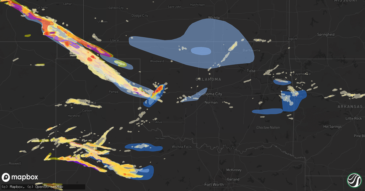
Hail Map in Oklahoma on June 6, 2025
Get this storm
June 6 map
$229
one time, instant access
Download today. No call, no setup
Keep the $229
Bought the map and want the full workflow? Apply the entire $229 to a subscription within 7 days. None of it is wasted.
Every map, not just this one
This buys you this map. Subscription and you get every map we run, in the markets you choose from a few cities to whole states to nationwide. Plus real-time alerts the moment a storm fires.
Contact data
Name, contact info, occupancy, even credit band for addresses in the footprint. You go from where it hit to who to call.
Become the source they trust
Unlimited branding weather history reports on demand. You already have the documented answer ready for the property owner, and you are the one who showed up with it.
Property data and RoofTrace estimates
Pull up any address you have got, its value and the exact code rules for that jurisdiction, straight from One Click Code. Then RoofTrace estimates the squares, pitch, and roof value, priced the way you price.
Storm reports in Oklahoma
Oklahoma
| Date | Description |
|---|---|
| 06/06/20256:54 PM CDT | A local report indicates a tornado near 2 S Keyes |
| 06/06/20256:12 PM CDT | A local report indicates 1.75 inch wind near 17 NNW Boise City |
| 06/06/20258:11 AM CDT | Report of a tree blocking highway 9 between spiro and stigler. |
| 06/06/20256:30 AM CDT | A local report indicates 62 MPH wind near 2 SW Wilburton |
| 06/06/20256:02 AM CDT | Emergency manager reports multiple large trees... Power lines... Power poles... Structure damage in the city of mcalester and krebs. Time estimated. |
| 06/06/20256:00 AM CDT | Corrects previous tstm wnd dmg report from mcalester. Extensive damage ito buildings in downtown mcalester. |
| 06/06/20255:17 AM CDT | Tds observed on inx radar at reported time. |
| 06/06/20255:10 AM CDT | A local report indicates 60 MPH wind near 6 ESE Peggs |
| 06/06/20255:00 AM CDT | Extensive damage ito buildings in downtown mcalester |
| 06/06/20255:00 AM CDT | Extensive damage ito buildings in downtown mcalester. |
| 06/06/20254:42 AM CDT | Trees down and power outages. |
| 06/06/20253:00 AM CDT | A local report indicates 58 MPH wind near 3 ENE Pawnee |
| 06/06/20252:45 AM CDT | Mesonet station newk newkirk. |
| 06/06/20252:35 AM CDT | Winds destroyed an irrigation pivot 3 south and 4 west of sayre. |
| 06/06/20252:35 AM CDT | Awos station kbkn blackwell. |
| 06/06/20252:10 AM CDT | Mesonet station medf medford. |
| 06/06/20252:05 AM CDT | Mesonet station medf medford. |
| 06/06/20252:03 AM CDT | Awos station kend enid vance afb. |
| 06/06/20251:58 AM CDT | Power outages. |
| 06/06/20251:58 AM CDT | Power is out. |
| 06/06/20251:54 AM CDT | A local report indicates 63 MPH wind near 3 E Pond Creek |
| 06/06/20251:50 AM CDT | Mesonet station laho lahoma. |
| 06/06/20251:45 AM CDT | A local report indicates 58 MPH wind near 1 S Jet |
| 06/06/20251:25 AM CDT | Asos station kswo stillwater. |
| 06/06/20251:25 AM CDT | Mesonet station cher cherokee. |
| 06/06/20251:15 AM CDT | A local report indicates 64 MPH wind near 2 S Alva |
| 06/06/20251:15 AM CDT | Mesonet station alv2 alva. |
| 06/06/202512:55 AM CDT | Mesonet station mayr may ranch. |
| 06/06/202512:50 AM CDT | Mesonet station mayr may ranch. |
| 06/06/202512:45 AM CDT | Mesonet station free freedom. |
| 06/06/202512:40 AM CDT | Tree downed. Individual trapped in tent. Time estimated by radar. |
| 06/06/202512:33 AM CDT | Report from mping: quarter |
| 06/06/202512:31 AM CDT | Report from mping: quarter |
| 06/06/202512:15 AM CDT | Mesonet station buff buffalo. |
| 06/06/202512:01 AM CDT | Asos station kpwa okla city wiley. |
| 06/05/202510:55 PM CDT | A local report indicates 1.75 inch wind near Guymon |
| 06/05/202510:50 PM CDT | Picture sent via social media of damage to the side of a house due to wind driven hail. |
| 06/05/202510:34 PM CDT | A local report indicates 2.75 inch wind near 4 E Hammon |
| 06/05/202510:33 PM CDT | A local report indicates 2.75 inch wind near Hammon |
| 06/05/202510:33 PM CDT | Delayed report. |
| 06/05/202510:23 PM CDT | A local report indicates 2.50 inch wind near 17 NNW Boise City |
| 06/05/202510:12 PM CDT | Emergency manager received reports of a tornado on the ground at this time. |
| 06/05/20259:45 PM CDT | A local report indicates 70 MPH wind near 2 S Sayre |
| 06/05/20258:11 PM CDT | Report on social media of hail damage to trailers and some broken windows. |
| 06/05/20258:06 PM CDT | A local report indicates 3.00 inch wind near 3 SW Goodwell |
| 06/05/20258:00 PM CDT | A local report indicates 1.75 inch wind near Goodwell |
| 06/05/20257:58 PM CDT | Picture sent via social media. |
| 06/05/20257:35 PM CDT | A local report indicates 1.75 inch wind near 10 SSE Eva |
All States Impacted by Hail Map on June 6, 2025
Cities Impacted by Hail Map on June 6, 2025
- Vian, OK
- Sallisaw, OK
- Ewing, IL
- Muldrow, OK
- Gans, OK
- Roland, OK
- Spiro, OK
- Belle Rive, IL
- Ina, IL
- Bonnie, IL
- Dahlgren, IL
- Van Buren, AR
- Macedonia, IL
- Rudy, AR
- Fort Smith, AR
- Arkoma, OK
- Alma, AR
- Mountainburg, AR
- Mulberry, AR
- Lavaca, AR
- Dyer, AR
- Barling, AR
- Pocola, OK
- Charleston, AR
- Cecil, AR
- Heavener, OK
- Hodgen, OK
- Salem, MO
- Ellington, MO
- Centerville, MO
- Redford, MO
- Black, MO
- Lesterville, MO
- Fredericktown, MO
- Waterford, OH
- Vincent, OH
- Fleming, OH
- Marietta, OH
- Lebanon, TN
- Watertown, TN
- Hardyville, KY
- Horse Cave, KY
- Alton, UT
- Greensburg, KY
- Sikeston, MO
- Canmer, KY
- Glasgow, KY
- Charleston, MO
- Gradyville, KY
- Columbia, KY
- Eighty Eight, KY
- Jackson, TN
- Oakfield, TN
- Humboldt, TN
- Maidsville, WV
- Big Rock, TN
- Norwood, CO
- Ridgway, CO
- Cairo, IL
- Dover, TN
- Campbellsville, KY
- Wickliffe, KY
- Indian Mound, TN
- Glens Fork, KY
- Clinton, KY
- Kevil, KY
- Paducah, KY
- La Center, KY
- West Paducah, KY
- Hillsborough, NH
- Henniker, NH
- Linden, TN
- Haywood, VA
- Madison, VA
- Reva, VA
- Miller City, IL
- Thebes, IL
- Olive Branch, IL
- Oakpark, VA
- Locust Dale, VA
- Radiant, VA
- Hampton, KY
- Smithland, KY
- Golconda, IL
- Orange, VA
- Brightwood, VA
- Rapidan, VA
- Culpeper, VA
- Bokoshe, OK
- Shady Point, OK
- Keota, OK
- Wister, OK
- Howe, OK
- Poteau, OK
- Greenwood, AR
- Cameron, OK
- Hackett, AR
- Huntington, AR
- Midland, AR
- Hartford, AR
- Columbia, TN
- Shelburne Falls, MA
- Charlemont, MA
- Contoocook, NH
- Colrain, MA
- East Prairie, MO
- Oakham, MA
- London, KY
- Athens, AL
- Bertrand, MO
- Barlow, KY
- Unionville, VA
- Warner, NH
- Bradford, NH
- Rutland, MA
- Lascassas, TN
- Antrim, NH
- Opdyke, IL
- Mount Vernon, IL
- Northfield, MA
- Mount Pleasant, TN
- Huntington, MA
- Chester, MA
- Concord, NH
- Melber, KY
- Milton, TN
- Louisa, VA
- Mineral, VA
- North Sutton, NH
- Wilmot, NH
- New London, NH
- Ashburnham, MA
- Alexandria, TN
- Pulaski, TN
- Worthington, MA
- Francestown, NH
- Warwick, MA
- Auburntown, TN
- Chesterfield, MA
- West Chesterfield, MA
- Prospect, TN
- Ardmore, TN
- Trenton, AL
- Paint Rock, AL
- Gurley, AL
- Deer Trail, CO
- Byers, CO
- Troy, VA
- Keswick, VA
- Cummington, MA
- Palmyra, VA
- Liberty, TN
- Greenfield, MA
- Williamsburg, MA
- Haydenville, MA
- West Hatfield, MA
- Easthampton, MA
- Cornersville, TN
- Lewisburg, TN
- Weare, NH
- Kim, CO
- Springer, NM
- Paris, TN
- Wendell, MA
- Orange, MA
- Palmersville, TN
- Sedalia, KY
- Dukedom, TN
- Dresden, TN
- South Deerfield, MA
- Conway, MA
- Calhan, CO
- Yoder, CO
- Granite Canon, WY
- Cheyenne, WY
- Fe Warren Afb, WY
- Burns, WY
- Hillsdale, WY
- Dillwyn, VA
- Cottage Grove, TN
- McKenzie, TN
- Fork Union, VA
- Columbia, VA
- Kents Store, VA
- Decherd, TN
- Monteagle, TN
- Goshen, MA
- New Salem, MA
- Dunbarton, NH
- Trezevant, TN
- Augusta, WV
- Limon, CO
- Florence, MA
- Leeds, MA
- Northampton, MA
- East Carbon, UT
- Pritchett, CO
- Buchanan, TN
- Springville, TN
- Puryear, TN
- Farmville, VA
- Gordonsville, TN
- Poughkeepsie, NY
- Pleasant Valley, NY
- Millbrook, NY
- Helper, UT
- Gleason, TN
- Capon Bridge, WV
- Martin, TN
- Larkspur, CO
- Wassaic, NY
- Dover Plains, NY
- Sharon, CT
- Athol, MA
- Sewanee, TN
- Gruetli Laager, TN
- Amenia, NY
- Genoa, CO
- Tatum, NM
- Crossroads, NM
- Milnesand, NM
- New Concord, KY
- Hazel, KY
- Murray, KY
- Blandford, MA
- West Cornwall, CT
- Goshen, CT
- Rice, VA
- Green Bay, VA
- Mansfield, TN
- Cleveland, TN
- McDonald, TN
- North Hatfield, MA
- Leeds, AL
- Moody, AL
- Campo, CO
- Westfield, MA
- Arriba, CO
- Lubbock, TX
- New Ipswich, NH
- Ashby, MA
- Burkeville, VA
- Beulah, CO
- Twin Bridges, CA
- Middletown, VA
- Dunlap, TN
- Ooltewah, TN
- Calhoun, TN
- Charleston, TN
- Falls Village, CT
- Norfolk, CT
- Pueblo, CO
- Odenville, AL
- Pell City, AL
- Idalou, TX
- Front Royal, VA
- Granville, MA
- Winsted, CT
- Southampton, MA
- Shallowater, TX
- Penrose, CO
- Holyoke, MA
- South Hadley, MA
- Old Fort, TN
- Cornwall Bridge, CT
- Ragland, AL
- Kenton, OK
- Boise City, OK
- Hugo, CO
- Lincoln, AL
- Southwick, MA
- Salt Flat, TX
- Apison, TN
- Ransom Canyon, TX
- Slaton, TX
- Lorenzo, TX
- Morton, TX
- Whiteface, TX
- Flagler, CO
- Attalla, AL
- Gadsden, AL
- Crewe, VA
- Blackstone, VA
- Kenbridge, VA
- Dundas, VA
- Alberta, VA
- Ohatchee, AL
- Steele, AL
- Rainbow City, AL
- Petersburg, TX
- Avondale, CO
- Fowler, CO
- Trinchera, CO
- Seibert, CO
- Vona, CO
- Waverly, TN
- Eva, TN
- Floydada, TX
- Butlerville, IN
- Holton, IN
- North Vernon, IN
- Green River, UT
- Lawrenceville, VA
- Tennessee Ridge, TN
- Stewart, TN
- Crandall, GA
- Mack, CO
- Loma, CO
- Fruita, CO
- Grand Junction, CO
- Ralls, TX
- Sugar City, CO
- Karval, CO
- Muleshoe, TX
- Sudan, TX
- Pecos, TX
- Colorado Springs, CO
- Elbert, CO
- Portales, NM
- Dolphin, VA
- Levelland, TX
- Stratton, CO
- Keyes, OK
- Model, CO
- Mentone, TX
- Maljamar, NM
- Counce, TN
- Michie, TN
- Lockney, TX
- Crosbyton, TX
- McEwen, TN
- Whitewater, CO
- Palisade, CO
- Clifton, CO
- Lovington, NM
- Dickson, TN
- Waterloo, AL
- Iuka, MS
- Savannah, TN
- Brookwood, AL
- Sundown, TX
- Post, TX
- Hobbs, NM
- La Junta, CO
- Bethune, CO
- Cheyenne Wells, CO
- Burlington, CO
- Goodwell, OK
- Rocky Ford, CO
- Texhoma, OK
- Grenville, NM
- Trinidad, CO
- Spur, TX
- Justiceburg, TX
- Snyder, TX
- Amherst, TX
- Gladstone, NM
- Lawrenceburg, TN
- Silverton, TX
- Ropesville, TX
- Burns, TN
- Quitaque, TX
- Wolfforth, TX
- Littlefield, TX
- Seminole, TX
- Arapahoe, CO
- Meadow, TX
- Bon Aqua, TN
- Las Animas, CO
- Tahoka, TX
- Wilson, TX
- Girard, TX
- Weskan, KS
- Rome, GA
- Armuchee, GA
- Anton, TX
- Jal, NM
- Guymon, OK
- Gruver, TX
- Abernathy, TX
- Jayton, TX
- Kermit, TX
- Childress, TX
- Tell, TX
- Brush Creek, TN
- Turkey, TX
- Plainville, GA
- Aspermont, TX
- Franklin, TN
- Hale Center, TX
- Roswell, NM
- Crawford, CO
- Dodson, TX
- Texhoma, TX
- New Deal, TX
- Springfield, CO
- Wetumpka, AL
- Quanah, TX
- Sharon Springs, KS
- Thompsons Station, TN
- Spearman, TX
- Hollis, OK
- Spring Hill, TN
- Tribune, KS
- Wellington, TX
- Gould, OK
- Vinson, OK
- Walsh, CO
- Tallassee, AL
- Erick, OK
- Willow, OK
- Miami, TX
- Perryton, TX
- Elida, NM
- Olustee, OK
- Duke, OK
- Mangum, OK
- Old Glory, TX
- Rotan, TX
- Belfast, TN
- Petersburg, TN
- Marion, KS
- Petersham, MA
- Templeton, MA
- Altus, OK
- Sayre, OK
- Montague, MA
- Leverett, MA
- Erving, MA
- Wendell Depot, MA
- Smyer, TX
- Royalston, MA
- Carter, OK
- Elk City, OK
- Wild Horse, CO
- Kit Carson, CO
- Hamlin, TX
- Rule, TX
- Andrews, TX
- Ulysses, KS
- Johnson, KS
- Elkhart, KS
- Fayetteville, TN
- Eads, CO
- Stamford, TX
- Haskell, TX
- Weinert, TX
- Rochester, TX
- Stratford, TX
- Mulberry, TN
- Rolla, KS
- Hammon, OK
- Butler, OK
- Canadian, TX
- Ingalls, KS
- Stinnett, TX
- Pampa, TX
- Canute, OK
- Dill City, OK
- Clinton, OK
- Custer City, OK
- Briscoe, TX
- Mobeetie, TX
- Carnegie, OK
- Cordell, OK
- Causey, NM
- Rogers, NM
- Earth, TX
- Richfield, KS
- Binger, OK
- Fort Cobb, OK
- Hydro, OK
- Avoca, TX
- Lueders, TX
- Cheyenne, OK
- Wheeler, TX
- Booker, TX
- Gunnison, CO
- Crawford, OK
- Westcliffe, CO
- Higgins, TX
- Hardesty, OK
- Rye, CO
- Paonia, CO
- Arnett, OK
- Parlin, CO
- Hotchkiss, CO
- Cedaredge, CO
- Walsenburg, CO
- Leedey, OK
- Montezuma, KS
- Dimmitt, TX
- Colony, OK
- Goldsmith, TX
- Hugoton, KS
- Olton, TX
- Hart, TX
- Fieldton, TX
- Plainview, TX
- Minco, OK
- Lookeba, OK
- Hinton, OK
- Larned, KS
- Burdett, KS
- Kress, TX
- Munday, TX
- Afton, TX
- Hooker, OK
- Dalhart, TX
- Reydon, OK
- Gracemont, OK
- Sweetwater, OK
- Meade, KS
- Clovis, NM
- Cannon Afb, NM
- Odessa, TX
- Paducah, TX
- Eclectic, AL
- Plains, KS
- Calumet, OK
- Geary, OK
- Seymour, TX
- Okarche, OK
- El Reno, OK
- Bristow, OK
- Kellyville, OK
- Texico, NM
- Beggs, OK
- Mounds, OK
- Anadarko, OK
- Union City, OK
- Yukon, OK
- Oklahoma City, OK
- Bethany, OK
- Mustang, OK
- Edmond, OK
- Piedmont, OK
- Sunray, TX
- Hennessey, OK
- Kingfisher, OK
- Farwell, TX
- Wagoner, OK
- Balko, OK
- Morse, TX
- Marshall, OK
- Inola, OK
- Chouteau, OK
- Guthrie, OK
- Arapaho, OK
- Lipscomb, TX
- Forgan, OK
- Gate, OK
- Rosston, OK
- Ashland, KS
- Buffalo, OK
- Englewood, KS
- May, OK
- Fort Supply, OK
- Woodward, OK
- Laverne, OK
- Mooreland, OK
- Alva, OK
- Coldwater, KS
- Chester, OK
- Protection, KS
- Freedom, OK
- Waynoka, OK
- Perry, OK
- Lucien, OK
- Covington, OK
- Orlando, OK
- Eufaula, OK
- Locust Grove, OK
- Salina, OK
- Cherokee, OK
- Dacoma, OK
- Burlington, OK
- Hulbert, OK
- Morrison, OK
- Red Rock, OK
- Pawnee, OK
- Tahlequah, OK
- Shamrock, TX
- Caney, KS
- Fairfax, OK
- Ralston, OK
- Ponca City, OK
- Kansas, OK
- Dickens, TX
- Crowell, TX
- Shidler, OK
- Ozark, AR
- Tyro, KS
- Coffeyville, KS
- Independence, KS
- Proctor, OK
- Burbank, OK
- Kaw City, OK
- Hereford, TX
- Sedan, KS
- Amorita, OK
- Hazelton, KS
- Kiowa, KS
- Waldron, KS
- Anthony, KS
- Manchester, OK
- Kremlin, OK
- Jet, OK
- Carrier, OK
- Wakita, OK
- Goltry, OK
- Lahoma, OK
- Pond Creek, OK
- Cleo Springs, OK
- Meno, OK
- Helena, OK
- Drummond, OK
- Ringwood, OK
- Carmen, OK
- Aline, OK
- Nash, OK
- Bison, OK
- Waukomis, OK
- Enid, OK
- Douglas, OK
- Tonkawa, OK
- Garber, OK
- Medford, OK
- Lamont, OK
- Billings, OK
- Fairmont, OK
- Bluff City, KS
- Hunter, OK
- Geuda Springs, KS
- South Haven, KS
- Freeport, KS
- Nardin, OK
- Newkirk, OK
- Braman, OK
- Marland, OK
- Oxford, KS
- Blackwell, OK
- Milan, KS
- Caldwell, KS
- Wellington, KS
- Mayfield, KS
- Deer Creek, OK
- Arkansas City, KS
- Winfield, KS
- Fairview, OK
- Lanagan, MO
- Noel, MO
- Dearing, KS
- Anderson, MO
- Mulhall, OK
- S Coffeyville, OK
- Wyandotte, OK
- Pineville, MO
- Goodman, MO
- Adrian, TX
- Stella, MO
- Neosho, MO
- Clearwater, KS
- Belle Plaine, KS
- Peck, KS
- Argonia, KS
- Viola, KS
- Conway Springs, KS
- Goddard, KS
- Spivey, KS
- Attica, KS
- Harper, KS
- Danville, KS
- Kingman, KS
- Norwich, KS
- Milton, KS
- Garden Plain, KS
- Cheney, KS
- Murdock, KS
- Sharon, KS
- Zenda, KS
- Hardtner, KS
- Medicine Lodge, KS
- Lake City, KS
- Atlanta, KS
- Mulvane, KS
- Douglass, KS
- Udall, KS
- Rock, KS
- Mcconnell Afb, KS
- Leon, KS
- Augusta, KS
- Wichita, KS
- Derby, KS
- Haysville, KS
- Rose Hill, KS
- Burden, KS
- Cambridge, KS
- Latham, KS
- Grenola, KS
- Hominy, OK
- Glencoe, OK
- Osage, OK
- Wynona, OK
- Cleveland, OK
- Prue, OK
- Maple City, KS
- Cedar Vale, KS
- Dexter, KS
- Pawhuska, OK
- Seneca, MO
- Welch, OK
- Bartlett, KS
- Edna, KS
- Siloam Springs, AR
- Watts, OK
- Summers, AR
- Knoxville, AR
- London, AR
- Mcadoo, TX
- Granby, MO
- Powell, MO
- Salisbury, NH
- Dover, AR
- Buckland, MA
- Washington, NH
- Kent, CT
- Fayetteville, AR
- Salt Point, NY
- Russell, MA
- Stoddard, NH
- Russellville, AR
- Vega, TX
- Shutesbury, MA
- Sentinel, OK
- Electra, TX
- Vernon, TX
- Ramona, OK
- Peru, KS
- Bartlesville, OK
- Skiatook, OK
- Ochelata, OK
- Barnsdall, OK
- Chautauqua, KS
- Dewey, OK
- Copan, OK
- Collinsville, OK
- Hector, AR
- Wildorado, TX
- Amarillo, TX
- Cleveland, AR
- Tecumseh, OK
- Center Ridge, AR
- Clinton, AR
- Bee Branch, AR
- Damascus, AR
- Fort Gibson, OK
- Park Hill, OK
- Welling, OK
- Cookson, OK
- Bunch, OK
- Stilwell, OK
- Maud, OK
- Konawa, OK
- Quitman, AR
- Claude, TX
- Seminole, OK
- Oark, AR
- Jerusalem, AR
- Scotland, AR
- Heber Springs, AR
- Westville, OK
- Rose Bud, AR
- Ashfield, MA
- Mcalester, OK
- Natural Dam, AR
- Chester, AR
- Prairie Grove, AR
- West Fork, AR
- Canadian, OK
- Uniontown, AR
- Hartshorne, OK
- Elkins, AR
- Winslow, AR
- Pangburn, AR
- Searcy, AR
- Letona, AR
- Wilburn, AR
- Cedarville, AR
- Krebs, OK
- Red Oak, OK
- Wilburton, OK
- Wesley, AR
- Combs, AR
- Greenbrier, AR
- Judsonia, AR
- Bald Knob, AR
- Russell, AR
- Bradford, AR


