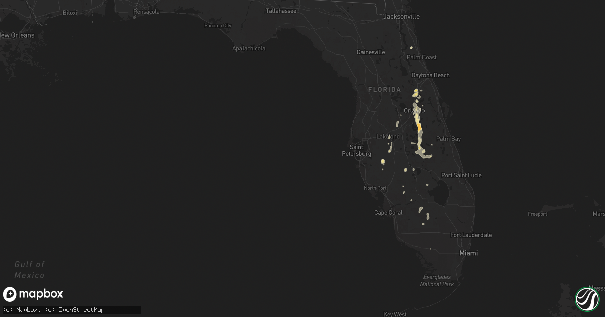
Hail Map in Florida on June 6, 2024
Get this storm
June 6 map
$229
one time, instant access
Download today. No call, no setup
Keep the $229
Bought the map and want the full workflow? Apply the entire $229 to a subscription within 7 days. None of it is wasted.
Every map, not just this one
This buys you this map. Subscription and you get every map we run, in the markets you choose from a few cities to whole states to nationwide. Plus real-time alerts the moment a storm fires.
Contact data
Name, contact info, occupancy, even credit band for addresses in the footprint. You go from where it hit to who to call.
Become the source they trust
Unlimited branding weather history reports on demand. You already have the documented answer ready for the property owner, and you are the one who showed up with it.
Property data and RoofTrace estimates
Pull up any address you have got, its value and the exact code rules for that jurisdiction, straight from One Click Code. Then RoofTrace estimates the squares, pitch, and roof value, priced the way you price.
Storm reports in Florida
Florida
| Date | Description |
|---|---|
| 06/06/20246:16 PM CDT | [delayed report] gas station awning collapsed at the 7-eleven gas station at the intersection of fl-436 and us-17/92. Time estimated with radar data. |
| 06/06/20246:13 PM CDT | [dalayed report] photo received of a large tree branch downed near the corner of lake and orlando ave in maitland. |
| 06/06/20246:12 PM CDT | Corrects previous tstm wnd dmg report from 1 nne fern park. [delayed report] gas station awning collapsed at the 7-eleven gas station at the intersection of fl-436 and |
| 06/06/20246:12 PM CDT | [delayed report] gas station awning collapsed at the 7-eleven gas station at the intersection of fl-436 and howell branch rd. Time estimated with radar data. Replaces p |
| 06/06/20246:00 PM CDT | [landspout] [delayed report] dot cameras show a likely landspout with lofted dust along fl-414 at the intersection of us-441. No damage has been reported. Kmlb radar i |
| 06/06/20245:58 PM CDT | [delayed report] trained spotter reports multiple large tree branches down with at least one falling on a van on/near lido and nadine sts... Just s of orlando executive |
| 06/06/20245:56 PM CDT | The asos at the orlando international airport measured a wind gust of 58mph/50kts from the south-southeast. Corrected event type. |
| 06/06/20245:54 PM CDT | Spotter reported quarter size hail south of st cloud. |
| 06/06/20245:50 PM CDT | Spotter reports golf ball sized hail near st cloud. |
| 06/06/20245:32 PM CDT | [landspout] hendry county emergency management confirmed reports of a brief landspout near county road 833 just south of the intersection of state road 80. Fire rescue |
Cities Impacted by Hail Map on June 6, 2024
- Ona, FL
- Myakka City, FL
- Parrish, FL
- Pampa, TX
- Rochelle, GA
- Abbeville, GA
- White Deer, TX
- Zolfo Springs, FL
- Sebring, FL
- Lake Placid, FL
- Chadbourn, NC
- Cerro Gordo, NC
- Fort Meade, FL
- Groom, TX
- Milan, GA
- Bartow, FL
- Rhine, GA
- Mulberry, FL
- Ochopee, FL
- Kenansville, FL
- Lakeland, FL
- Bolton, NC
- Hastings, FL
- Elkton, FL
- Stinnett, TX
- Frostproof, FL
- Labelle, FL
- Eaton Park, FL
- Punta Gorda, FL
- Riegelwood, NC
- Currie, NC
- Panhandle, TX
- Astor, FL
- Polk City, FL
- Lake Wales, FL
- Borger, TX
- Perryton, TX
- River Ranch, FL
- Deltona, FL
- Altoona, FL
- Burgaw, NC
- Rocky Point, NC
- Arcadia, FL
- Higgins, TX
- Debary, FL
- Miami, TX
- Clermont, FL
- Canadian, TX
- Fritch, TX
- Orange City, FL
- Winter Garden, FL
- Saint Cloud, FL
- Oviedo, FL
- Parkton, NC
- Hope Mills, NC
- Masterson, TX
- Winter Park, FL
- Maitland, FL
- Kissimmee, FL
- Orlando, FL
- Clewiston, FL
- Taloga, OK
- Sanford, FL
- Seiling, OK
- Longwood, FL
- Winter Springs, FL
- Lake Mary, FL
- Arnett, OK
- Casselberry, FL
- Okeechobee, FL
- Altamonte Springs, FL
- Elko, NV
- Shattuck, OK
- Sharon, OK
- Gage, OK
- Amarillo, TX
- Vega, TX
- Vici, OK
- Fargo, OK
- Sayre, OK
- Camargo, OK
- Elk City, OK
- Summerfield, TX
- Wellington, TX
- Quail, TX
- Immokalee, FL
- Shamrock, TX
- Hereford, TX
- Meadow, TX
- Tahoka, TX
- Wolfforth, TX
- Lubbock, TX
- Wilson, TX
- Slaton, TX
- Post, TX
- Sunray, TX
- Happy, TX
- Wayside, TX
- Claude, TX
- Canyon, TX
- Dimmitt, TX
- Nazareth, TX
- Tulia, TX
- Springlake, TX
- Hart, TX
- Olton, TX
- Kress, TX
- Plainview, TX
- Hale Center, TX
- Silverton, TX


