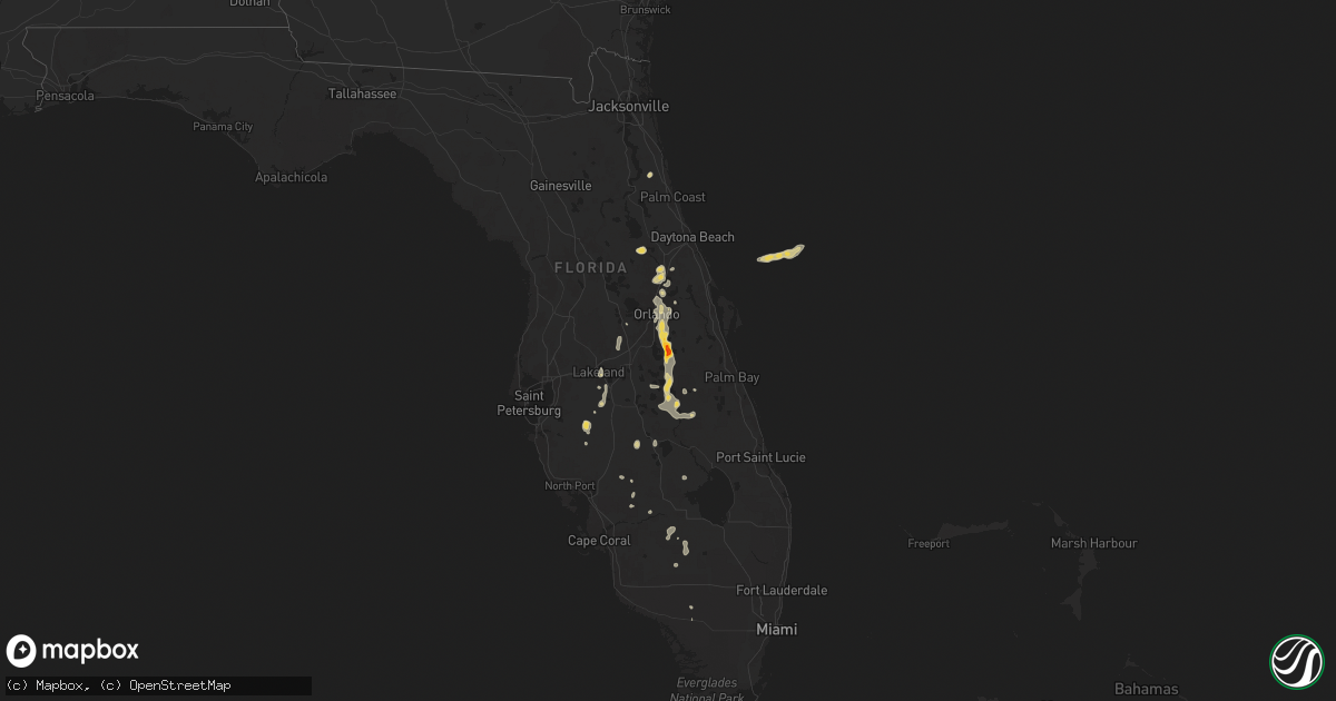
Hail Map on June 6, 2024
Get this storm
June 6 map
$229
one time, instant access
Download today. No call, no setup
Keep the $229
Bought the map and want the full workflow? Apply the entire $229 to a subscription within 7 days. None of it is wasted.
Every map, not just this one
This buys you this map. Subscription and you get every map we run, in the markets you choose from a few cities to whole states to nationwide. Plus real-time alerts the moment a storm fires.
Contact data
Name, contact info, occupancy, even credit band for addresses in the footprint. You go from where it hit to who to call.
Become the source they trust
Unlimited branding weather history reports on demand. You already have the documented answer ready for the property owner, and you are the one who showed up with it.
Property data and RoofTrace estimates
Pull up any address you have got, its value and the exact code rules for that jurisdiction, straight from One Click Code. Then RoofTrace estimates the squares, pitch, and roof value, priced the way you price.
Storm reports
North Carolina
| Date | Description |
|---|---|
| 06/06/20246:53 PM CDT | Several trees down in the mount olive area... Including one down on a house. |
| 06/06/20245:37 PM CDT | Power outages reported by jones-onslow electric coop. |
| 06/06/20245:13 PM CDT | A few tree limbs down up to ~2 inch diameter. Dime sized hail also reported. |
| 06/06/20244:13 PM CDT | Tree down at oxford rd near john moore rd and thomas store rd. |
| 06/06/20244:02 PM CDT | Tree down at leasburg rd and dee long rd. |
| 06/06/20244:02 PM CDT | Tree down at lucy garrett rd and moss creek dr. |
| 06/06/20243:53 PM CDT | Tree down at preston george rd and ormond rd. |
| 06/05/20248:59 PM CDT | Nearly 1000 power outages were reported due to fallen trees on power lines near the town of pilot. |
| 06/05/20248:58 PM CDT | Several trees down across the pantego and belhaven area... Including swindell rd... Sydney rd... And us 264. Time estimated based on radar data. |
| 06/05/20248:58 PM CDT | Several trees |
| 06/05/20248:55 PM CDT | A tree was reported down near the intersection of nc highway 98 west and curtis rd in bunn. |
| 06/05/20248:34 PM CDT | Several trees down across the roadway near washington... Including highland dr. And corsica rd. |
| 06/05/20247:35 PM CDT | Lenoir county em called to report power lines down and trees down on hwy 55... Near moss hill elementary school... Hwy 903... And liddell road. |
Nevada
| Date | Description |
|---|---|
| 06/06/20246:42 PM CDT | Mesonet station spmn2 spruce mountain raws station elevation: 6295 ft. |
| 06/05/20249:42 PM CDT | Mesonet station alrn2 antelope lake raws station elevation: 5459 ft. |
| 06/05/20248:37 PM CDT | Mesonet station morn2 morey creek raws station elevation: 5500 ft. |
Virginia
| Date | Description |
|---|---|
| 06/06/20244:20 PM CDT | Tree downed at intersection of bible rd and cellar creek rd in nottoway per va 511 website. Time is radar estimated. |
| 06/06/20244:05 PM CDT | Tree downed on cellar creek rd per va511 website. |
| 06/06/20242:57 PM CDT | Corrects previous tstm wnd dmg report from 1 ene farmville. Tree down on east side of farmville. Time is radar estimated. |
| 06/06/20242:57 PM CDT | Corrects previous tstm wnd dmg report from 1 ene farmville. Tree down on east side of farmville. Time is radar estimated. |
| 06/06/20242:48 PM CDT | Large tree limbs downed at tabscott road at shannon hill road. Power outages also reported in the area. Time radar estimated. |
| 06/06/20242:40 PM CDT | Tree down on east side of farmville. |
Florida
| Date | Description |
|---|---|
| 06/06/20246:16 PM CDT | [delayed report] gas station awning collapsed at the 7-eleven gas station at the intersection of fl-436 and us-17/92. Time estimated with radar data. |
| 06/06/20246:13 PM CDT | [dalayed report] photo received of a large tree branch downed near the corner of lake and orlando ave in maitland. |
| 06/06/20246:12 PM CDT | Corrects previous tstm wnd dmg report from 1 nne fern park. [delayed report] gas station awning collapsed at the 7-eleven gas station at the intersection of fl-436 and |
| 06/06/20246:12 PM CDT | [delayed report] gas station awning collapsed at the 7-eleven gas station at the intersection of fl-436 and howell branch rd. Time estimated with radar data. Replaces p |
| 06/06/20246:00 PM CDT | [landspout] [delayed report] dot cameras show a likely landspout with lofted dust along fl-414 at the intersection of us-441. No damage has been reported. Kmlb radar i |
| 06/06/20245:58 PM CDT | [delayed report] trained spotter reports multiple large tree branches down with at least one falling on a van on/near lido and nadine sts... Just s of orlando executive |
| 06/06/20245:56 PM CDT | The asos at the orlando international airport measured a wind gust of 58mph/50kts from the south-southeast. Corrected event type. |
| 06/06/20245:54 PM CDT | Spotter reported quarter size hail south of st cloud. |
| 06/06/20245:50 PM CDT | Spotter reports golf ball sized hail near st cloud. |
| 06/06/20245:32 PM CDT | [landspout] hendry county emergency management confirmed reports of a brief landspout near county road 833 just south of the intersection of state road 80. Fire rescue |
Texas
| Date | Description |
|---|---|
| 06/06/20245:05 PM CDT | A local report indicates 1.50 inch wind near Stinnett |
| 06/06/20245:00 PM CDT | Accumulating hail of quarter size. |
| 06/06/20243:26 PM CDT | Golf ball size hail approximately 7 miles south of pampa on texas highway 70. |
| 06/05/20249:01 PM CDT | A local report indicates 64 MPH wind near 6 ENE Amarillo |
| 06/05/20248:57 PM CDT | Severe gusts intermittently occurred between 8:55 pm and 8:58 pm. |
| 06/05/20248:43 PM CDT | Severe gusts continued through 8:44 pm. |
| 06/05/20248:33 PM CDT | Severe gusts continued through 8:34 pm. |
| 06/05/20248:31 PM CDT | Power lines down on south washington street near the 3400 block. Time estimated by radar. |
| 06/05/20247:47 PM CDT | Picture sent to us of 8-12 inch tree branches snapped and blocking road. |
| 06/05/20247:40 PM CDT | A local report indicates 62 MPH wind near 3 NNW Palo Duro Canyon |
| 06/05/20247:30 PM CDT | Picture sent to us of fence blown over from reported microburst near the intersection of 37th and coulter street. |
| 06/05/20247:27 PM CDT | A local report indicates 59 MPH wind near 4 SSW Pantex |
| 06/05/20247:15 PM CDT | Corrects previous tstm wnd dmg report from 2 sw amarillo. Power lines down on south washington street near the 3400 block. Time estimated by radar. |
| 06/05/20247:15 PM CDT | Two large trees down near the intersection of 34th and georgia street. |
Georgia
| Date | Description |
|---|---|
| 06/06/20243:45 PM CDT | Tree reported down at the intersection of plainfield rd and firehouse rd. |
| 06/06/20243:45 PM CDT | Tree down on home at intersection of middle ground church rd and ga hwy 126. |
| 06/06/20243:45 PM CDT | Trees down on powerlines at intersection of plainfield rd and firehouse rd. |
| 06/06/20243:42 PM CDT | A manufactured home had a roof blown off by strong winds. Two trees then fell on the structure. |
| 06/06/202412:56 PM CDT | The city of edison facebook page reported a tree down on a power line on manry street. |
Cities Impacted by Hail Map on June 6, 2024
- Ona, FL
- Myakka City, FL
- Parrish, FL
- Pampa, TX
- Rochelle, GA
- Abbeville, GA
- White Deer, TX
- Zolfo Springs, FL
- Sebring, FL
- Lake Placid, FL
- Chadbourn, NC
- Cerro Gordo, NC
- Fort Meade, FL
- Groom, TX
- Milan, GA
- Bartow, FL
- Rhine, GA
- Mulberry, FL
- Ochopee, FL
- Kenansville, FL
- Lakeland, FL
- Bolton, NC
- Hastings, FL
- Elkton, FL
- Stinnett, TX
- Frostproof, FL
- Labelle, FL
- Eaton Park, FL
- Punta Gorda, FL
- Riegelwood, NC
- Currie, NC
- Panhandle, TX
- Astor, FL
- Polk City, FL
- Lake Wales, FL
- Borger, TX
- Perryton, TX
- River Ranch, FL
- Deltona, FL
- Altoona, FL
- Burgaw, NC
- Rocky Point, NC
- Arcadia, FL
- Higgins, TX
- Debary, FL
- Miami, TX
- Clermont, FL
- Canadian, TX
- Fritch, TX
- Orange City, FL
- Winter Garden, FL
- Saint Cloud, FL
- Oviedo, FL
- Parkton, NC
- Hope Mills, NC
- Masterson, TX
- Winter Park, FL
- Maitland, FL
- Kissimmee, FL
- Orlando, FL
- Clewiston, FL
- Taloga, OK
- Sanford, FL
- Seiling, OK
- Longwood, FL
- Winter Springs, FL
- Lake Mary, FL
- Arnett, OK
- Casselberry, FL
- Okeechobee, FL
- Altamonte Springs, FL
- Elko, NV
- Shattuck, OK
- Sharon, OK
- Gage, OK
- Amarillo, TX
- Vega, TX
- Vici, OK
- Fargo, OK
- Sayre, OK
- Camargo, OK
- Elk City, OK
- Summerfield, TX
- Wellington, TX
- Quail, TX
- Immokalee, FL
- Shamrock, TX
- Hereford, TX
- Meadow, TX
- Tahoka, TX
- Wolfforth, TX
- Lubbock, TX
- Wilson, TX
- Slaton, TX
- Post, TX
- Sunray, TX
- Happy, TX
- Wayside, TX
- Claude, TX
- Canyon, TX
- Dimmitt, TX
- Nazareth, TX
- Tulia, TX
- Springlake, TX
- Hart, TX
- Olton, TX
- Kress, TX
- Plainview, TX
- Hale Center, TX
- Silverton, TX