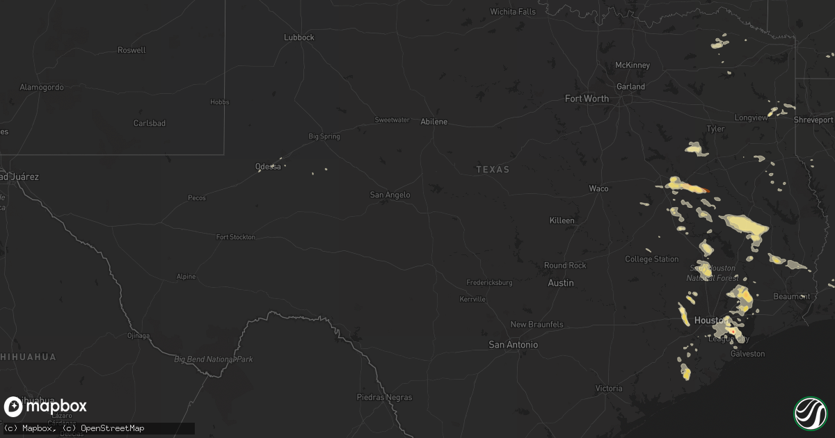
Hail Map in Texas on June 6, 2013
Get this storm
June 6 map
$229
one time, instant access
Download today. No call, no setup
Keep the $229
Bought the map and want the full workflow? Apply the entire $229 to a subscription within 7 days. None of it is wasted.
Every map, not just this one
This buys you this map. Subscription and you get every map we run, in the markets you choose from a few cities to whole states to nationwide. Plus real-time alerts the moment a storm fires.
Contact data
Name, contact info, occupancy, even credit band for addresses in the footprint. You go from where it hit to who to call.
Become the source they trust
Unlimited branding weather history reports on demand. You already have the documented answer ready for the property owner, and you are the one who showed up with it.
Property data and RoofTrace estimates
Pull up any address you have got, its value and the exact code rules for that jurisdiction, straight from One Click Code. Then RoofTrace estimates the squares, pitch, and roof value, priced the way you price.
Storm reports in Texas
Texas
| Date | Description |
|---|---|
| 06/06/20136:33 PM CDT | A local report indicates 60 MPH wind near 7 N VIDOR |
| 06/06/20136:20 PM CDT | Sheriffs dept reports numerous trees down and power outages in the lumberton area. |
| 06/06/20136:16 PM CDT | Tree down in new caney on heights blvd. |
| 06/06/20136:16 PM CDT | Golfball hail in liberty. |
| 06/06/20136:15 PM CDT | Trees down in dayton |
| 06/06/20135:40 PM CDT | Trees down at the corner of fm 1725 and highway 105 in cleveland. |
| 06/06/20135:35 PM CDT | Sheriffs dept reports numerous trees down in the jasper area. |
| 06/06/20135:25 PM CDT | Sign snapped off and blown into a wrecker truck damaging the vehicle around 525 pm near calvary road and interstate 45. |
| 06/06/20135:16 PM CDT | Sheriffs dept reports numerous trees down from colmesneil to woodville. |
| 06/06/20135:00 PM CDT | Tree down across fm 1669 on the north side of huntington. |
| 06/06/20134:46 PM CDT | Trees down near highway 190 in livingston. |
| 06/06/20134:45 PM CDT | Wind gust to 30 mph. |
| 06/06/20134:42 PM CDT | Numerous trees down along highway 59 just south of diboll. |
| 06/06/20134:42 PM CDT | Wind gusts to 70 mph taken along highway 59 just south of diboll. |
| 06/06/20134:31 PM CDT | Trees down along highway 287 near carmona. |
| 06/06/20134:31 PM CDT | Large limbs down in diboll. |
| 06/06/20134:30 PM CDT | Trees and power lines down in the northern part of polk county. |
| 06/06/20134:16 PM CDT | Numerous trees and power lines down...especially between apple springs and groveton. |
| 06/06/20133:50 PM CDT | Trees down throughout houston county. |
| 06/06/20133:18 PM CDT | Report from buna sawmill. |
| 06/06/20133:12 PM CDT | Quarter size hail reported in the northern city limits of grapeland. |
| 06/06/20133:09 PM CDT | Pea size hail and trees down near grapeland. |
| 06/06/20133:06 PM CDT | Nickle to quarter size hail with wind gusts to 55 mph at spivey road. |
| 06/06/20139:12 AM CDT | Several trees down on power lines just outside linden |
| 06/06/20137:00 AM CDT | Wind blew down a tree and threw a trampoline 30 yards over a house |
| 06/05/20137:30 PM CDT | Tennis ball size hail just north of seabrook. |
| 06/05/20137:30 PM CDT | Tennis ball size hail in seabrook. |
| 06/05/20137:20 PM CDT | Photo from public showing 1.25 inch hail. |
| 06/05/20137:12 PM CDT | Quarter size hail at the corner of interstate 10 and west loop of beltway 8 in channelview. |
| 06/05/20137:05 PM CDT | Golfball size hail reported on fry road between little york and fm 529. |
All States Impacted by Hail Map on June 6, 2013
Cities Impacted by Hail Map on June 6, 2013
- Dayton, TX
- Huffman, TX
- Liberty, TX
- Lake Charles, LA
- Deer Park, TX
- La Porte, TX
- Folsom, LA
- Livingston, TX
- Corrigan, TX
- Garden City, TX
- Loranger, LA
- Elkhart, TX
- San Augustine, TX
- Willis, TX
- New Waverly, TX
- Huntsville, TX
- Conroe, TX
- Pasadena, TX
- Seabrook, TX
- Ama, LA
- Fairfield, TX
- Oakwood, TX
- Grapeland, TX
- Buffalo, TX
- Eudora, AR
- Mansfield, LA
- Nacogdoches, TX
- Annona, TX
- Avery, TX
- El Dorado, AR
- Warren, TX
- Fred, TX
- Spurger, TX
- Morton, MS
- Pelahatchie, MS
- Fresno, TX
- Louisville, MS
- Lacombe, LA
- Lena, MS
- Hockley, TX
- Richmond, TX
- Cypress, TX
- Katy, TX
- Saint Rose, LA
- Destrehan, LA
- Westwego, LA
- Luling, LA
- Centerville, TX
- Channelview, TX
- Tomball, TX
- Macon, MS
- Cleveland, TX
- Baytown, TX
- Highlands, TX
- Crosby, TX
- Houston, TX
- Chester, TX
- Sweeny, TX
- Bay City, TX
- Newhebron, MS
- Iowa, LA
- Montezuma, NM
- Marshall, TX
- Mooringsport, LA
- Karnack, TX
- Sulphur, LA
- Vinton, LA
- Madisonville, TX
- Midway, TX
- Groveton, TX
- Moscow, TX
- Diboll, TX
- Apple Springs, TX
- Bay Springs, MS
- Louin, MS
- Brandon, MS
- Braxton, MS
- Kinder, LA
- Leona, TX
- Trinity, TX
- Buna, TX
- Slidell, LA
- Trinchera, CO
- Call, TX
- Silsbee, TX
- Kirbyville, TX
- Jefferson, TX
- Kaplan, LA
- Thornton, TX
- Buckner, AR
- Gheens, LA
- Damon, TX
- Welsh, LA
- Larue, TX
- Frankston, TX
- Mora, NM
- Rociada, NM
- Midland, TX
- Dequincy, LA
- Devers, TX
- Hankamer, TX
- Holman, NM
- Cleveland, NM
- Center, TX
- Timpson, TX
- New Iberia, LA
- Jeanerette, LA
- Palestine, TX
- Chacon, NM
- Braithwaite, LA
- Belle Chasse, LA
- Crockett, TX
- Mount Pleasant, TX
- Moselle, MS
- Hattiesburg, MS
- Oakhurst, TX
- Bogata, TX
- Deweyville, TX
- Raleigh, MS
- Silver Creek, MS
- Brazoria, TX
- Long Branch, TX
- Garrison, TX
- Mount Enterprise, TX
- Mendenhall, MS
- Bryan, TX
- Anahuac, TX
- Wallisville, TX
- Ragley, LA
- Pinehurst, TX
- Magnolia, TX
- Jewett, TX
- Lovelady, TX
- Monticello, MS
- Natchez, LA
- Natchitoches, LA
- Talco, TX
- Converse, LA
- Las Vegas, NM
- Clarksville, TX
- Iota, LA
- Kentwood, LA
- Chamisal, NM
- Stanley, NM
- Branson, CO
- Folsom, NM
- Webster, TX
- Friendswood, TX
- Branch, LA
- Galena Park, TX
- Alvin, TX
- Pearland, TX
- Bacliff, TX
- Dickinson, TX
- South Houston, TX
- Sugar Land, TX
- Deport, TX
- New Orleans, LA
- Van Vleck, TX
- Boling, TX
- Pledger, TX
- Seminary, MS
- Texas City, TX
- La Marque, TX
- Marrero, LA
- Orange, TX
- Woodville, TX
- Pennington, TX
- Forest, MS
- Hull, TX
- League City, TX
- Harrisville, MS
- Georgetown, MS
- Kennard, TX
- Odessa, TX
- Youngsville, LA
- Ellisville, MS
- Laneville, TX
- Needville, TX
- North Zulch, TX
- Boutte, LA
- Paradis, LA
- Guy, TX
- Mount Vernon, TX
- Pinola, MS
- Manvel, TX
- Lafayette, LA
- Stamps, AR
- Wesson, MS
- Jacksonville, TX
- Athens, TX
- Kim, CO
- Teague, TX
- Kenner, LA
- Worden, MT
- Big Timber, MT
- Melville, MT
- Hysham, MT
- Roundup, MT
- Custer, MT
- Ingomar, MT
- Musselshell, MT
- Ryegate, MT
- Lavina, MT
- Rapelje, MT
- Broadview, MT
- Lodge Grass, MT
- Shawmut, MT
- Wolf, WY
- Arvada, WY
- Clearmont, WY
- Recluse, WY
- Gillette, WY
- Sheridan, WY
- Ranchester, WY
- Joliet, MT
- Red Lodge, MT
- Roberts, MT
- Roscoe, MT
- Billings, MT
- Shepherd, MT
- Huntley, MT


