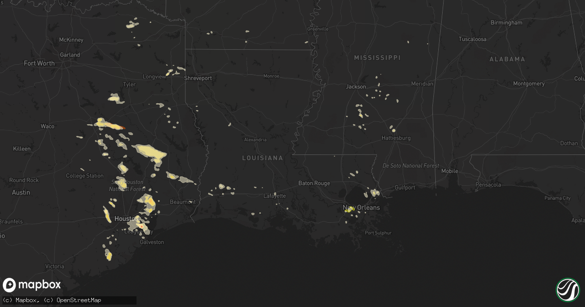
Hail Map in Louisiana on June 6, 2013
Get this storm
June 6 map
$229
one time, instant access
Download today. No call, no setup
Keep the $229
Bought the map and want the full workflow? Apply the entire $229 to a subscription within 7 days. None of it is wasted.
Every map, not just this one
This buys you this map. Subscription and you get every map we run, in the markets you choose from a few cities to whole states to nationwide. Plus real-time alerts the moment a storm fires.
Contact data
Name, contact info, occupancy, even credit band for addresses in the footprint. You go from where it hit to who to call.
Become the source they trust
Unlimited branding weather history reports on demand. You already have the documented answer ready for the property owner, and you are the one who showed up with it.
Property data and RoofTrace estimates
Pull up any address you have got, its value and the exact code rules for that jurisdiction, straight from One Click Code. Then RoofTrace estimates the squares, pitch, and roof value, priced the way you price.
Storm reports in Louisiana
Louisiana
| Date | Description |
|---|---|
| 06/06/20136:55 PM CDT | Delayed report from off duty nws employee that observed 2 trees down along highway 12 near dequincy. Time estimated from radar. |
| 06/06/20135:10 PM CDT | Quarter size hail in marrero relayed via social media. |
| 06/06/20134:55 PM CDT | Trees down along magnolia ridge rd and old spanish trail in boutte. |
| 06/06/20134:50 PM CDT | Hail up to 1 inch in luling. |
| 06/06/20134:42 PM CDT | Reports of quarter size hail in st rose. |
| 06/06/20134:41 PM CDT | Quarter size hail reported along duncan street in slidell. |
| 06/06/20134:40 PM CDT | A few trees down along highway 307 in chackbay. |
| 06/06/20134:29 PM CDT | 1.25 inch hail reported by off duty nws employee near indian village. |
| 06/06/20131:15 PM CDT | A few trees blown down in the moss bluff area |
| 06/06/201312:45 PM CDT | Sheriffs dept reports tree down at camp edgewood. |
| 06/06/20139:55 AM CDT | Multiple trees down near barrons marina - s. Lakeshore drive at pines road |
| 06/05/20137:30 PM CDT | Power poles snapped off on alamo street near memorial hospital. |
| 06/05/20137:26 PM CDT | Storm survey finds microburst damage with the axis just north of i-210 in the south portion of lake charles. Several trees were snapped. In addition power poles were sn |
| 06/05/20137:07 PM CDT | Calcasieu em reported power poles down on the west side of suphur on picard st. |
| 06/05/20137:00 PM CDT | Vinton pd reported several small trees across roadway. |
All States Impacted by Hail Map on June 6, 2013
Cities Impacted by Hail Map on June 6, 2013
- Dayton, TX
- Huffman, TX
- Liberty, TX
- Lake Charles, LA
- Deer Park, TX
- La Porte, TX
- Folsom, LA
- Livingston, TX
- Corrigan, TX
- Garden City, TX
- Loranger, LA
- Elkhart, TX
- San Augustine, TX
- Willis, TX
- New Waverly, TX
- Huntsville, TX
- Conroe, TX
- Pasadena, TX
- Seabrook, TX
- Ama, LA
- Fairfield, TX
- Oakwood, TX
- Grapeland, TX
- Buffalo, TX
- Eudora, AR
- Mansfield, LA
- Nacogdoches, TX
- Annona, TX
- Avery, TX
- El Dorado, AR
- Warren, TX
- Fred, TX
- Spurger, TX
- Morton, MS
- Pelahatchie, MS
- Fresno, TX
- Louisville, MS
- Lacombe, LA
- Lena, MS
- Hockley, TX
- Richmond, TX
- Cypress, TX
- Katy, TX
- Saint Rose, LA
- Destrehan, LA
- Westwego, LA
- Luling, LA
- Centerville, TX
- Channelview, TX
- Tomball, TX
- Macon, MS
- Cleveland, TX
- Baytown, TX
- Highlands, TX
- Crosby, TX
- Houston, TX
- Chester, TX
- Sweeny, TX
- Bay City, TX
- Newhebron, MS
- Iowa, LA
- Montezuma, NM
- Marshall, TX
- Mooringsport, LA
- Karnack, TX
- Sulphur, LA
- Vinton, LA
- Madisonville, TX
- Midway, TX
- Groveton, TX
- Moscow, TX
- Diboll, TX
- Apple Springs, TX
- Bay Springs, MS
- Louin, MS
- Brandon, MS
- Braxton, MS
- Kinder, LA
- Leona, TX
- Trinity, TX
- Buna, TX
- Slidell, LA
- Trinchera, CO
- Call, TX
- Silsbee, TX
- Kirbyville, TX
- Jefferson, TX
- Kaplan, LA
- Thornton, TX
- Buckner, AR
- Gheens, LA
- Damon, TX
- Welsh, LA
- Larue, TX
- Frankston, TX
- Mora, NM
- Rociada, NM
- Midland, TX
- Dequincy, LA
- Devers, TX
- Hankamer, TX
- Holman, NM
- Cleveland, NM
- Center, TX
- Timpson, TX
- New Iberia, LA
- Jeanerette, LA
- Palestine, TX
- Chacon, NM
- Braithwaite, LA
- Belle Chasse, LA
- Crockett, TX
- Mount Pleasant, TX
- Moselle, MS
- Hattiesburg, MS
- Oakhurst, TX
- Bogata, TX
- Deweyville, TX
- Raleigh, MS
- Silver Creek, MS
- Brazoria, TX
- Long Branch, TX
- Garrison, TX
- Mount Enterprise, TX
- Mendenhall, MS
- Bryan, TX
- Anahuac, TX
- Wallisville, TX
- Ragley, LA
- Pinehurst, TX
- Magnolia, TX
- Jewett, TX
- Lovelady, TX
- Monticello, MS
- Natchez, LA
- Natchitoches, LA
- Talco, TX
- Converse, LA
- Las Vegas, NM
- Clarksville, TX
- Iota, LA
- Kentwood, LA
- Chamisal, NM
- Stanley, NM
- Branson, CO
- Folsom, NM
- Webster, TX
- Friendswood, TX
- Branch, LA
- Galena Park, TX
- Alvin, TX
- Pearland, TX
- Bacliff, TX
- Dickinson, TX
- South Houston, TX
- Sugar Land, TX
- Deport, TX
- New Orleans, LA
- Van Vleck, TX
- Boling, TX
- Pledger, TX
- Seminary, MS
- Texas City, TX
- La Marque, TX
- Marrero, LA
- Orange, TX
- Woodville, TX
- Pennington, TX
- Forest, MS
- Hull, TX
- League City, TX
- Harrisville, MS
- Georgetown, MS
- Kennard, TX
- Odessa, TX
- Youngsville, LA
- Ellisville, MS
- Laneville, TX
- Needville, TX
- North Zulch, TX
- Boutte, LA
- Paradis, LA
- Guy, TX
- Mount Vernon, TX
- Pinola, MS
- Manvel, TX
- Lafayette, LA
- Stamps, AR
- Wesson, MS
- Jacksonville, TX
- Athens, TX
- Kim, CO
- Teague, TX
- Kenner, LA
- Worden, MT
- Big Timber, MT
- Melville, MT
- Hysham, MT
- Roundup, MT
- Custer, MT
- Ingomar, MT
- Musselshell, MT
- Ryegate, MT
- Lavina, MT
- Rapelje, MT
- Broadview, MT
- Lodge Grass, MT
- Shawmut, MT
- Wolf, WY
- Arvada, WY
- Clearmont, WY
- Recluse, WY
- Gillette, WY
- Sheridan, WY
- Ranchester, WY
- Joliet, MT
- Red Lodge, MT
- Roberts, MT
- Roscoe, MT
- Billings, MT
- Shepherd, MT
- Huntley, MT


