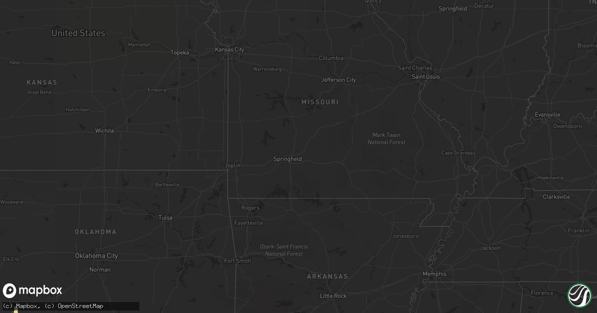
Hail Map in Florida on June 6, 2012
Get this storm
June 6 map
$229
one time, instant access
Download today. No call, no setup
Keep the $229
Bought the map and want the full workflow? Apply the entire $229 to a subscription within 7 days. None of it is wasted.
Every map, not just this one
This buys you this map. Subscription and you get every map we run, in the markets you choose from a few cities to whole states to nationwide. Plus real-time alerts the moment a storm fires.
Contact data
Name, contact info, occupancy, even credit band for addresses in the footprint. You go from where it hit to who to call.
Become the source they trust
Unlimited branding weather history reports on demand. You already have the documented answer ready for the property owner, and you are the one who showed up with it.
Property data and RoofTrace estimates
Pull up any address you have got, its value and the exact code rules for that jurisdiction, straight from One Click Code. Then RoofTrace estimates the squares, pitch, and roof value, priced the way you price.
Storm reports in Florida
Florida
| Date | Description |
|---|---|
| 06/06/20126:45 PM CDT | A few trees and power lines down from tstm winds around jackson county |
| 06/06/201212:35 PM CDT | 1 tree down. Tree fell on the holy ground homeless shelter. Time estimated by radar. |
| 06/06/20127:50 AM CDT | Numerous trees reported down throughout southeastern miami-dade county...mainly in the areas between homestead and cutler bay. Time of damage ranged between 800 and 900 |
| 06/06/20127:35 AM CDT | A member of the public estimated wind gusts to 60 mph in perrine...near the intersection of us 1 and southwest 168th street at 835 am edt. Business signs were blown off |
| 06/06/20127:34 AM CDT | A member of the public estimated wind gusts to 60 mph in west kendall...near the intersection of southwest 120th street and the florida turnpike at 834 am edt. |
| 06/06/20127:32 AM CDT | A trained spotter reported quarter-sized hail just west of the cutler bay area...near the intersection of us 1 and caribbean boulevard at 832 am edt. |
| 06/06/20127:25 AM CDT | An off-duty nws employee estimated wind gusts to 60 mph in homestead...near the intersection of southwest 259th street and southwest 125th avenue at 825 am edt. |
| 06/06/20127:22 AM CDT | A ham radio operator esimated wind gusts to 60 mph in princeton...near the intersection of southwest 253rd street and southwest 137th avenue at 822 am edt. |
| 06/06/20127:18 AM CDT | A trained spotter reported wind gusts between 55 and 60 mph near the intersection of us 1 and southwest 248th street at 818 am edt. |
| 06/06/20127:11 AM CDT | A member of the public reported quarter-sized hail in leisure citiy...near the intersection of southwest 288th street and the florida turnpike at 811 am edt. |
All States Impacted by Hail Map on June 6, 2012
Cities Impacted by Hail Map on June 6, 2012
- Esmond, ND
- Godley, TX
- Raton, NM
- Aurora, CO
- Lone Tree, CO
- Englewood, CO
- Galeton, CO
- Gill, CO
- Eaton, CO
- Parker, CO
- Itasca, TX
- Hillsboro, TX
- Milford, TX
- Nocona, TX
- Saint Jo, TX
- Voltaire, ND
- Velva, ND
- Elgin, ND
- Flasher, ND
- Almont, ND
- Raleigh, ND
- Carson, ND
- Plainview, TX
- Abernathy, TX
- Hale Center, TX
- Coppell, TX
- Irving, TX
- Lakeview, TX
- Frisco, TX
- Little Elm, TX
- Folsom, NM
- Alto, TX
- Nacogdoches, TX
- Lufkin, TX
- Pollok, TX
- Wells, TX
- Keenesburg, CO
- Roggen, CO
- Maurice, LA
- Hart, TX
- Kress, TX
- Cushing, TX
- Douglass, TX
- Morgan, TX
- Kopperl, TX
- Grover, CO
- Briggsdale, CO
- Lyman, NE
- Gering, NE
- Mitchell, NE
- Morrill, NE
- Lake Charles, LA
- Iowa, LA
- Clarendon, TX
- Childress, TX
- Matador, TX
- Midway, TX
- Bell City, LA
- Flint, TX
- Chandler, TX
- Larue, TX
- Bullard, TX
- Frankston, TX
- Bedias, TX
- Huntsville, TX
- Bainbridge, GA
- Fort Morgan, CO
- Brush, CO
- Branson, CO
- Weatherford, TX
- Maddock, ND
- Oberon, ND
- Pierre Part, LA
- Morgan City, LA
- Karlsruhe, ND
- Balfour, ND
- Oakwood, TX
- Buffalo, TX
- Littleton, CO
- Denver, CO
- Kountze, TX
- Realitos, TX
- Spurger, TX
- Fred, TX
- Hillister, TX
- Weston, CO
- Hawley, TX
- Bowbells, ND
- Troup, TX
- Eustace, TX
- Malakoff, TX
- Athens, TX
- Franktown, CO
- Castle Rock, CO
- Elizabeth, CO
- Bennett, CO
- Oakhurst, TX
- Pointblank, TX
- Kennard, TX
- Grapeland, TX
- Pinehurst, TX
- Magnolia, TX
- Hereford, CO
- Cheyenne, WY
- Meriden, WY
- Albin, WY
- Lagrange, WY
- Pine Bluffs, WY
- Hillsdale, WY
- Carpenter, WY
- Burns, WY
- Ringgold, TX
- Bridgeport, TX
- Gainesville, TX
- Lafayette, LA
- Granbury, TX
- Lipan, TX
- Spring, TX
- Singer, LA
- Longville, MN
- Saucier, MS
- Pequot Lakes, MN
- Pine River, MN
- Lockport, LA
- Colorado Springs, CO
- Woodville, TX
- Bowie, TX
- Brookeland, TX
- Jasper, TX
- Trinchera, CO
- Chireno, TX
- Palestine, TX
- Valley View, TX
- Surrey, ND
- Norwich, ND
- Rugby, ND
- Sanger, TX
- Jacksboro, TX
- Baird, TX
- Kemp, TX
- Scurry, TX
- Donnybrook, ND
- Stanley, ND
- Palermo, ND
- Whitesboro, TX
- Burkeville, TX
- Newton, TX
- Bon Wier, TX
- Era, TX
- Rosston, TX
- Muenster, TX
- Commerce City, CO
- Vernon, TX
- Elmer, OK
- Kenmare, ND
- Cairo, GA
- Ochlocknee, GA
- Thomasville, GA
- Abilene, TX
- Altamonte Springs, FL
- Longwood, FL
- Cleburne, TX
- Wills Point, TX
- Ryder, ND
- Douglas, ND
- Whitehouse, TX
- Trinity, TX
- Sherman, TX
- Henderson, TX
- Desoto, TX
- Red Oak, TX
- Morse, LA
- Estherwood, LA
- Rayne, LA
- Crowley, LA
- Tyler, TX
- Houston, TX
- Winter Springs, FL
- Sanford, FL
- Denison, TX
- Pottsboro, TX
- Conifer, CO
- Lance Creek, WY
- Garyville, LA
- La Place, LA
- Reserve, LA
- Zephyr, TX
- Broaddus, TX
- San Augustine, TX
- Glenburn, ND
- Sulphur, LA
- Westlake, LA
- Rockwall, TX
- Dublin, TX
- Hico, TX
- Argyle, TX
- Hayes, SD
- Clifton, TX
- Cranfills Gap, TX
- Springtown, TX
- Paradise, TX
- Wood Lake, MN
- Hanley Falls, MN
- Oelrichs, SD
- Chadron, NE
- Baton Rouge, LA
- Baker, LA
- Blum, TX
- Covington, TX
- Bellevue, TX
- Bena, MN
- Houma, LA
- Hawk Springs, WY
- Torrington, WY
- Yoder, WY
- Ponchatoula, LA
- Garrison, ND
- Roseglen, ND
- Beulah, ND
- Zap, ND
- Fairfield, TX
- Forestburg, TX
- Montague, TX
- Antler, ND
- Sunset, TX
- Alvord, TX
- Plano, TX
- Krum, TX
- Corsicana, TX
- Fountain, CO
- Kaplan, LA
- Abbeville, LA
- New Iberia, LA
- Lewisville, TX
- Carrollton, TX
- The Colony, TX
- Lubbock, TX
- New Deal, TX
- Idalou, TX
- Strawn, TX
- Ranger, TX
- Towner, ND
- Blackduck, MN
- Squaw Lake, MN
- De Leon, TX
- Mexia, TX
- Maxbass, ND
- Glen Ullin, ND
- Lacombe, LA
- Albany, TX
- Petersburg, TX
- Livingston, TX
- Moran, TX
- Anson, TX
- Sedalia, CO
- Olton, TX
- Remer, MN
- Deer River, MN
- Federal Dam, MN
- Altus, OK
- Keene, TX
- Deweyville, TX
- Fort Worth, TX
- Louviers, CO
- Morrison, CO
- Watkins, CO
- Mullin, TX
- Merryville, LA
- Springfield, LA
- Peyton, CO
- Homestead, FL
- Miami, FL
- Trinidad, CO
- Boncarbo, CO
- New Rockford, ND
- Crowley, TX
- Des Allemands, LA
- Gray, LA
- Chico, TX
- Dallas, TX
- White Castle, LA
- Claude, TX
- Groom, TX
- Evergreen, CO
- Kiowa, CO
- Saratoga, TX
- Gueydan, LA
- Early, TX
- Dequincy, LA
- Youngsville, LA
- Prairieville, LA
- Geismar, LA
- Jennings, LA
- Haskell, TX
- Weinert, TX
- Rusk, TX
- Jacksonville, TX
- Brule, WI
- Iron River, WI
- Terrell, TX
- Stamford, TX
- Teague, TX
- Robertsdale, AL
- Madisonville, TX
- Model, CO
- Normangee, TX
- Minot, ND
- Denton, TX
- Campbellton, FL
- Burleson, TX
- Joshua, TX
- Granville, ND
- Desdemona, TX
- Mohall, ND
- Ragley, LA
- Midlothian, TX
- Venus, TX
- Maypearl, TX
- Alvarado, TX
- Grandview, TX
- Aubrey, TX
- Balta, ND
- Call, TX
- Boston, GA
- Alliance, NE
- Rule, TX
- Mabank, TX
- West Branch, MI
- Trinidad, TX
- Encino, TX
- Lansford, ND
- Azle, TX
- Denham Springs, LA
- Walker, LA
- Stephenville, TX
- Golden, CO
- Des Moines, NM
- Capulin, NM
- Perkinston, MS
- Lueders, TX
- Strasburg, CO
- Carrington, ND
- Edgewood, TX
- Rio Vista, TX
- Quinlan, TX
- Brownsboro, TX
- Winona, TX
- Cut Off, LA
- Larose, LA
- Max, ND
- Crockett, TX
- Elkhart, TX
- Holt, FL
- Milton, FL
- Hamilton, TX
- Pottsville, TX
- Meridian, TX
- Evant, TX
- Jefferson, CO
- Kirbyville, TX
- Moscow, TX
- Justin, TX
- Ponder, TX
- Minnewaukan, ND
- Fort Pierre, SD
- Tennessee Colony, TX
- Garland, TX
- Zachary, LA
- Rhome, TX
- Boyd, TX
- Decatur, TX
- Kaufman, TX
- Crestview, FL
- Baker, FL
- Orange, TX
- Livingston, LA
- Duson, LA
- Erath, LA
- Colmesneil, TX
- Canton, TX
- Kerens, TX
- Groesbeck, TX
- Longville, LA
- Wylie, TX
- Richardson, TX
- Allen, TX
- Gonzales, LA
- Carr, CO
- Lake Arthur, LA
- Pavo, GA
- Warren, TX
- Orchard, CO
- Tie Siding, WY
- Chugwater, WY
- Raceland, LA
- Luling, LA
- Shawnee, CO
- Addison, TX
- Coldspring, TX
- Brownwood, TX
- Gladwin, MI
- Pine Grove, LA
- Amite, LA
- Mart, TX
- Gordon, TX
- Welsh, LA
- Lacassine, LA
- Beaverton, MI
- Harris, MN
- Grantsburg, WI
- Montalba, TX
- Fruitvale, TX
- Goldthwaite, TX
- Prosper, TX
- Hendrix, OK
- Colbert, OK
- Durant, OK
- Calera, OK
- Waxahachie, TX
- Dixie, GA
- Rhodes, MI
- Crosslake, MN
- Wellington, CO
- Greenwood, FL
- Reklaw, TX
- Laneville, TX
- Ellsworth, NE
- Grand Chenier, LA
- Hudson, CO
- Wiggins, CO
- Memphis, TX
- Bosler, WY
- Starks, LA
- Avoca, TX
- Greenwell Springs, LA
- Gheens, LA
- Olustee, OK
- Evans, LA
- Deridder, LA
- Broussard, LA
- Lovelady, TX
- Comanche, TX
- Terral, OK
- Ryan, OK
- Hurst, TX
- Marianna, FL


