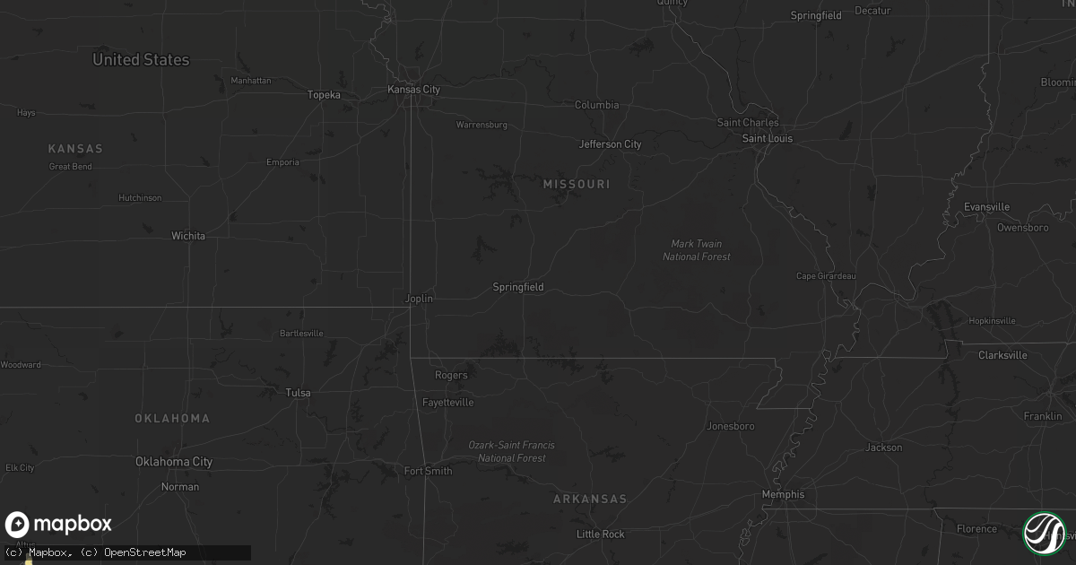
Hail Map in Colorado on June 6, 2012
Get this storm
June 6 map
$229
one time, instant access
Download today. No call, no setup
Keep the $229
Bought the map and want the full workflow? Apply the entire $229 to a subscription within 7 days. None of it is wasted.
Every map, not just this one
This buys you this map. Subscription and you get every map we run, in the markets you choose from a few cities to whole states to nationwide. Plus real-time alerts the moment a storm fires.
Contact data
Name, contact info, occupancy, even credit band for addresses in the footprint. You go from where it hit to who to call.
Become the source they trust
Unlimited branding weather history reports on demand. You already have the documented answer ready for the property owner, and you are the one who showed up with it.
Property data and RoofTrace estimates
Pull up any address you have got, its value and the exact code rules for that jurisdiction, straight from One Click Code. Then RoofTrace estimates the squares, pitch, and roof value, priced the way you price.
Storm reports in Colorado
Colorado
| Date | Description |
|---|---|
| 06/06/20126:28 PM CDT | A local report indicates 1.00 inch wind near 3 W BRIGGSDALE |
| 06/06/20126:05 PM CDT | Small landspout just north of denver international airport |
| 06/06/20125:57 PM CDT | A local report indicates 1.25 inch wind near 8 SW KEOTA |
| 06/06/20125:56 PM CDT | A local report indicates 1.00 inch wind near 1 E SEGUNDO |
| 06/06/20125:45 PM CDT | Delayed report of 1 inch diameter hail. |
| 06/06/20122:10 AM CDT | Quebec and c-470 |
| 06/06/20121:55 AM CDT | Street flooding with water running over the curbs |
| 06/06/20121:00 AM CDT | Ping pong sized hail kipling and hamden |
| 06/06/201212:10 AM CDT | A local report indicates 1.00 inch wind near CENTENNIAL |
| 06/06/201212:08 AM CDT | Hail covered the ground to a depth of two inches |
| 06/06/201212:00 AM CDT | Hail covered the ground to a depth of three inches |
| 06/05/201211:55 PM CDT | A local report indicates 1.00 inch wind near LONE TREE |
| 06/05/201211:35 PM CDT | A local report indicates 1.75 inch wind near HIGHLANDS RANCH |
| 06/05/201210:40 PM CDT | A local report indicates 1.25 inch wind near PARKER |
| 06/05/201210:30 PM CDT | A local report indicates 1.00 inch wind near HIGHLANDS RANCH |
| 06/05/201210:23 PM CDT | A local report indicates 1.00 inch wind near 4 W SEGUNDO |
| 06/05/201210:03 PM CDT | A local report indicates 1.00 inch wind near HIGHLANDS RANCH |
| 06/05/20129:57 PM CDT | A local report indicates 66 MPH wind near DENVER INTL AIRPORT |
| 06/05/20129:56 PM CDT | Hail covered the ground to a depth of two inches |
| 06/05/20129:54 PM CDT | Nickel to quarter sized hail covered the ground to a depth of several inches |
| 06/05/20129:51 PM CDT | On the ground for several minutes |
| 06/05/20129:48 PM CDT | A local report indicates 1.50 inch wind near 5 SSW ARAPAHOE PARK |
| 06/05/20129:44 PM CDT | Hail fell at 800pm mdt. |
| 06/05/20129:30 PM CDT | A local report indicates 1.75 inch wind near 3 W THE PINERY |
| 06/05/20129:24 PM CDT | A local report indicates 1.00 inch wind near 3 SSW CASTLE PINES |
| 06/05/20129:16 PM CDT | Fell at 803 pm mdt. |
| 06/05/20129:06 PM CDT | A local report indicates 1.00 inch wind near 4 SSE COLORADO SPRINGS |
| 06/05/20128:49 PM CDT | A local report indicates 1.75 inch wind near 2 NE COLORADO SPRINGS |
| 06/05/20128:49 PM CDT | 1.50 inches of rain. |
| 06/05/20128:48 PM CDT | A local report indicates 1.75 inch wind near 4 SSE COLORADO SPRINGS |
| 06/05/20128:45 PM CDT | A local report indicates a tornado near 14 SW BENNETT |
| 06/05/20128:44 PM CDT | A local report indicates a tornado near 12 NW KIOWA |
| 06/05/20128:44 PM CDT | A local report indicates 1.00 inch wind near 2 SSW COLORADO SPRINGS |
| 06/05/20128:43 PM CDT | A local report indicates 1.50 inch wind near 4 WSW COLORADO SPRINGS |
| 06/05/20128:40 PM CDT | A local report indicates a tornado near 5 NW ELIZABETH |
| 06/05/20128:40 PM CDT | A local report indicates 1.25 inch wind near 3 SE COLORADO SPRINGS |
| 06/05/20128:33 PM CDT | A local report indicates 1.25 inch wind near 3 SE COLORADO SPRINGS |
| 06/05/20128:32 PM CDT | A local report indicates 1.25 inch wind near 4 SW COLORADO SPRINGS |
| 06/05/20128:30 PM CDT | 720 to 724pm mdt |
| 06/05/20128:30 PM CDT | A local report indicates a tornado near 10 WSW KIOWA |
| 06/05/20128:26 PM CDT | A local report indicates 1.75 inch wind near 2 NE COLORADO SPRINGS |
| 06/05/20128:22 PM CDT | A local report indicates 1.25 inch wind near 4 WSW COLORADO SPRINGS |
| 06/05/20128:21 PM CDT | A local report indicates 1.25 inch wind near 5 NNW PETERSON AFB |
| 06/05/20128:20 PM CDT | A local report indicates 60 MPH wind near 3 NE PETERSON AFB |
| 06/05/20128:19 PM CDT | A local report indicates 1.25 inch wind near 4 ENE COLORADO SPRINGS |
| 06/05/20128:19 PM CDT | A local report indicates 1.50 inch wind near 7 NE COLORADO SPRINGS |
| 06/05/20128:19 PM CDT | Home gutters being ripped off of house by hail fall. |
| 06/05/20128:14 PM CDT | A local report indicates 1.00 inch wind near 3 NNW COLORADO SPRINGS |
| 06/05/20128:14 PM CDT | A local report indicates 60 MPH wind near 3 NNW COLORADO SPRINGS |
| 06/05/20128:13 PM CDT | A local report indicates 1.00 inch wind near 6 NNE COLORADO SPRINGS |
| 06/05/20128:10 PM CDT | A local report indicates 1.00 inch wind near 3 N PETERSON AFB |
| 06/05/20128:05 PM CDT | A local report indicates 1.00 inch wind near THE PINERY |
| 06/05/20128:04 PM CDT | A local report indicates 1.50 inch wind near 3 ENE COLORADO SPRINGS |
| 06/05/20128:02 PM CDT | A local report indicates 1.25 inch wind near 7 NE COLORADO SPRINGS |
| 06/05/20128:01 PM CDT | A local report indicates 1.00 inch wind near 2 NE COLORADO SPRINGS |
| 06/05/20128:00 PM CDT | A local report indicates 1.00 inch wind near 3 SE COLORADO SPRINGS |
| 06/05/20128:00 PM CDT | A local report indicates 1.00 inch wind near PARKER |
| 06/05/20127:56 PM CDT | A local report indicates 1.00 inch wind near 7 NNE COLORADO SPRINGS |
| 06/05/20127:54 PM CDT | A local report indicates 1.00 inch wind near 5 SSW BLACK FOREST |
| 06/05/20127:53 PM CDT | A local report indicates 1.00 inch wind near 6 NNE COLORADO SPRINGS |
| 06/05/20127:51 PM CDT | A local report indicates 1.00 inch wind near 5 SSW BLACK FOREST |
| 06/05/20127:45 PM CDT | A local report indicates 1.75 inch wind near 5 NE PARKER |
| 06/05/20127:38 PM CDT | Tornado ripped out small tree and threw it 20 feet |
| 06/05/20127:00 PM CDT | A local report indicates 1.00 inch wind near 12 W KEOTA |
All States Impacted by Hail Map on June 6, 2012
Cities Impacted by Hail Map on June 6, 2012
- Esmond, ND
- Godley, TX
- Raton, NM
- Aurora, CO
- Lone Tree, CO
- Englewood, CO
- Galeton, CO
- Gill, CO
- Eaton, CO
- Parker, CO
- Itasca, TX
- Hillsboro, TX
- Milford, TX
- Nocona, TX
- Saint Jo, TX
- Voltaire, ND
- Velva, ND
- Elgin, ND
- Flasher, ND
- Almont, ND
- Raleigh, ND
- Carson, ND
- Plainview, TX
- Abernathy, TX
- Hale Center, TX
- Coppell, TX
- Irving, TX
- Lakeview, TX
- Frisco, TX
- Little Elm, TX
- Folsom, NM
- Alto, TX
- Nacogdoches, TX
- Lufkin, TX
- Pollok, TX
- Wells, TX
- Keenesburg, CO
- Roggen, CO
- Maurice, LA
- Hart, TX
- Kress, TX
- Cushing, TX
- Douglass, TX
- Morgan, TX
- Kopperl, TX
- Grover, CO
- Briggsdale, CO
- Lyman, NE
- Gering, NE
- Mitchell, NE
- Morrill, NE
- Lake Charles, LA
- Iowa, LA
- Clarendon, TX
- Childress, TX
- Matador, TX
- Midway, TX
- Bell City, LA
- Flint, TX
- Chandler, TX
- Larue, TX
- Bullard, TX
- Frankston, TX
- Bedias, TX
- Huntsville, TX
- Bainbridge, GA
- Fort Morgan, CO
- Brush, CO
- Branson, CO
- Weatherford, TX
- Maddock, ND
- Oberon, ND
- Pierre Part, LA
- Morgan City, LA
- Karlsruhe, ND
- Balfour, ND
- Oakwood, TX
- Buffalo, TX
- Littleton, CO
- Denver, CO
- Kountze, TX
- Realitos, TX
- Spurger, TX
- Fred, TX
- Hillister, TX
- Weston, CO
- Hawley, TX
- Bowbells, ND
- Troup, TX
- Eustace, TX
- Malakoff, TX
- Athens, TX
- Franktown, CO
- Castle Rock, CO
- Elizabeth, CO
- Bennett, CO
- Oakhurst, TX
- Pointblank, TX
- Kennard, TX
- Grapeland, TX
- Pinehurst, TX
- Magnolia, TX
- Hereford, CO
- Cheyenne, WY
- Meriden, WY
- Albin, WY
- Lagrange, WY
- Pine Bluffs, WY
- Hillsdale, WY
- Carpenter, WY
- Burns, WY
- Ringgold, TX
- Bridgeport, TX
- Gainesville, TX
- Lafayette, LA
- Granbury, TX
- Lipan, TX
- Spring, TX
- Singer, LA
- Longville, MN
- Saucier, MS
- Pequot Lakes, MN
- Pine River, MN
- Lockport, LA
- Colorado Springs, CO
- Woodville, TX
- Bowie, TX
- Brookeland, TX
- Jasper, TX
- Trinchera, CO
- Chireno, TX
- Palestine, TX
- Valley View, TX
- Surrey, ND
- Norwich, ND
- Rugby, ND
- Sanger, TX
- Jacksboro, TX
- Baird, TX
- Kemp, TX
- Scurry, TX
- Donnybrook, ND
- Stanley, ND
- Palermo, ND
- Whitesboro, TX
- Burkeville, TX
- Newton, TX
- Bon Wier, TX
- Era, TX
- Rosston, TX
- Muenster, TX
- Commerce City, CO
- Vernon, TX
- Elmer, OK
- Kenmare, ND
- Cairo, GA
- Ochlocknee, GA
- Thomasville, GA
- Abilene, TX
- Altamonte Springs, FL
- Longwood, FL
- Cleburne, TX
- Wills Point, TX
- Ryder, ND
- Douglas, ND
- Whitehouse, TX
- Trinity, TX
- Sherman, TX
- Henderson, TX
- Desoto, TX
- Red Oak, TX
- Morse, LA
- Estherwood, LA
- Rayne, LA
- Crowley, LA
- Tyler, TX
- Houston, TX
- Winter Springs, FL
- Sanford, FL
- Denison, TX
- Pottsboro, TX
- Conifer, CO
- Lance Creek, WY
- Garyville, LA
- La Place, LA
- Reserve, LA
- Zephyr, TX
- Broaddus, TX
- San Augustine, TX
- Glenburn, ND
- Sulphur, LA
- Westlake, LA
- Rockwall, TX
- Dublin, TX
- Hico, TX
- Argyle, TX
- Hayes, SD
- Clifton, TX
- Cranfills Gap, TX
- Springtown, TX
- Paradise, TX
- Wood Lake, MN
- Hanley Falls, MN
- Oelrichs, SD
- Chadron, NE
- Baton Rouge, LA
- Baker, LA
- Blum, TX
- Covington, TX
- Bellevue, TX
- Bena, MN
- Houma, LA
- Hawk Springs, WY
- Torrington, WY
- Yoder, WY
- Ponchatoula, LA
- Garrison, ND
- Roseglen, ND
- Beulah, ND
- Zap, ND
- Fairfield, TX
- Forestburg, TX
- Montague, TX
- Antler, ND
- Sunset, TX
- Alvord, TX
- Plano, TX
- Krum, TX
- Corsicana, TX
- Fountain, CO
- Kaplan, LA
- Abbeville, LA
- New Iberia, LA
- Lewisville, TX
- Carrollton, TX
- The Colony, TX
- Lubbock, TX
- New Deal, TX
- Idalou, TX
- Strawn, TX
- Ranger, TX
- Towner, ND
- Blackduck, MN
- Squaw Lake, MN
- De Leon, TX
- Mexia, TX
- Maxbass, ND
- Glen Ullin, ND
- Lacombe, LA
- Albany, TX
- Petersburg, TX
- Livingston, TX
- Moran, TX
- Anson, TX
- Sedalia, CO
- Olton, TX
- Remer, MN
- Deer River, MN
- Federal Dam, MN
- Altus, OK
- Keene, TX
- Deweyville, TX
- Fort Worth, TX
- Louviers, CO
- Morrison, CO
- Watkins, CO
- Mullin, TX
- Merryville, LA
- Springfield, LA
- Peyton, CO
- Homestead, FL
- Miami, FL
- Trinidad, CO
- Boncarbo, CO
- New Rockford, ND
- Crowley, TX
- Des Allemands, LA
- Gray, LA
- Chico, TX
- Dallas, TX
- White Castle, LA
- Claude, TX
- Groom, TX
- Evergreen, CO
- Kiowa, CO
- Saratoga, TX
- Gueydan, LA
- Early, TX
- Dequincy, LA
- Youngsville, LA
- Prairieville, LA
- Geismar, LA
- Jennings, LA
- Haskell, TX
- Weinert, TX
- Rusk, TX
- Jacksonville, TX
- Brule, WI
- Iron River, WI
- Terrell, TX
- Stamford, TX
- Teague, TX
- Robertsdale, AL
- Madisonville, TX
- Model, CO
- Normangee, TX
- Minot, ND
- Denton, TX
- Campbellton, FL
- Burleson, TX
- Joshua, TX
- Granville, ND
- Desdemona, TX
- Mohall, ND
- Ragley, LA
- Midlothian, TX
- Venus, TX
- Maypearl, TX
- Alvarado, TX
- Grandview, TX
- Aubrey, TX
- Balta, ND
- Call, TX
- Boston, GA
- Alliance, NE
- Rule, TX
- Mabank, TX
- West Branch, MI
- Trinidad, TX
- Encino, TX
- Lansford, ND
- Azle, TX
- Denham Springs, LA
- Walker, LA
- Stephenville, TX
- Golden, CO
- Des Moines, NM
- Capulin, NM
- Perkinston, MS
- Lueders, TX
- Strasburg, CO
- Carrington, ND
- Edgewood, TX
- Rio Vista, TX
- Quinlan, TX
- Brownsboro, TX
- Winona, TX
- Cut Off, LA
- Larose, LA
- Max, ND
- Crockett, TX
- Elkhart, TX
- Holt, FL
- Milton, FL
- Hamilton, TX
- Pottsville, TX
- Meridian, TX
- Evant, TX
- Jefferson, CO
- Kirbyville, TX
- Moscow, TX
- Justin, TX
- Ponder, TX
- Minnewaukan, ND
- Fort Pierre, SD
- Tennessee Colony, TX
- Garland, TX
- Zachary, LA
- Rhome, TX
- Boyd, TX
- Decatur, TX
- Kaufman, TX
- Crestview, FL
- Baker, FL
- Orange, TX
- Livingston, LA
- Duson, LA
- Erath, LA
- Colmesneil, TX
- Canton, TX
- Kerens, TX
- Groesbeck, TX
- Longville, LA
- Wylie, TX
- Richardson, TX
- Allen, TX
- Gonzales, LA
- Carr, CO
- Lake Arthur, LA
- Pavo, GA
- Warren, TX
- Orchard, CO
- Tie Siding, WY
- Chugwater, WY
- Raceland, LA
- Luling, LA
- Shawnee, CO
- Addison, TX
- Coldspring, TX
- Brownwood, TX
- Gladwin, MI
- Pine Grove, LA
- Amite, LA
- Mart, TX
- Gordon, TX
- Welsh, LA
- Lacassine, LA
- Beaverton, MI
- Harris, MN
- Grantsburg, WI
- Montalba, TX
- Fruitvale, TX
- Goldthwaite, TX
- Prosper, TX
- Hendrix, OK
- Colbert, OK
- Durant, OK
- Calera, OK
- Waxahachie, TX
- Dixie, GA
- Rhodes, MI
- Crosslake, MN
- Wellington, CO
- Greenwood, FL
- Reklaw, TX
- Laneville, TX
- Ellsworth, NE
- Grand Chenier, LA
- Hudson, CO
- Wiggins, CO
- Memphis, TX
- Bosler, WY
- Starks, LA
- Avoca, TX
- Greenwell Springs, LA
- Gheens, LA
- Olustee, OK
- Evans, LA
- Deridder, LA
- Broussard, LA
- Lovelady, TX
- Comanche, TX
- Terral, OK
- Ryan, OK
- Hurst, TX
- Marianna, FL


