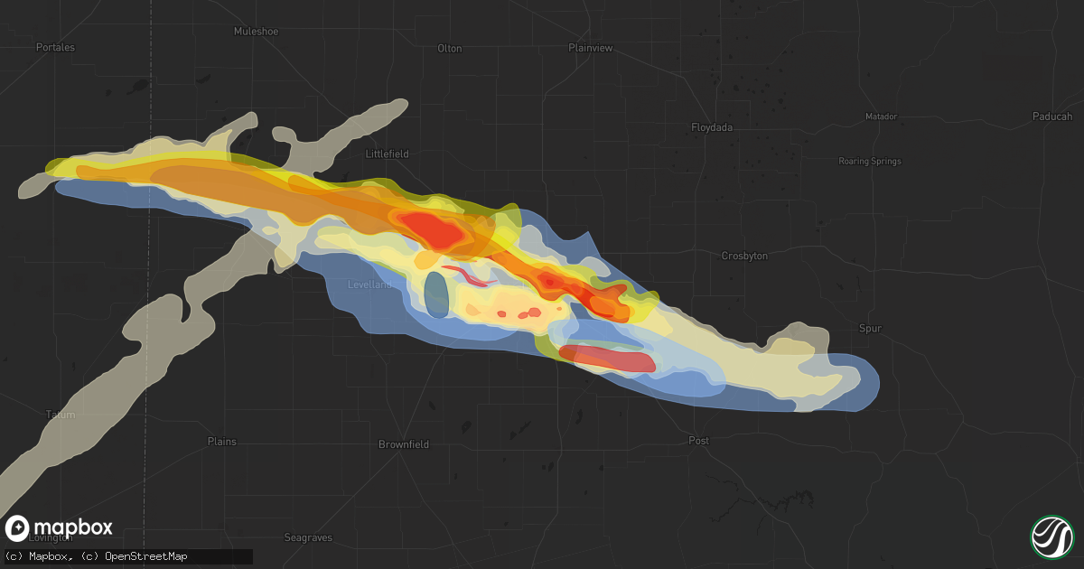
Hail Map in Lubbock, TX on June 5, 2025
Get this storm
June 5 map
$229
one time, instant access
Download today. No call, no setup
Keep the $229
Bought the map and want the full workflow? Apply the entire $229 to a subscription within 7 days. None of it is wasted.
Every map, not just this one
This buys you this map. Subscription and you get every map we run, in the markets you choose from a few cities to whole states to nationwide. Plus real-time alerts the moment a storm fires.
Contact data
Name, contact info, occupancy, even credit band for addresses in the footprint. You go from where it hit to who to call.
Become the source they trust
Unlimited branding weather history reports on demand. You already have the documented answer ready for the property owner, and you are the one who showed up with it.
Property data and RoofTrace estimates
Pull up any address you have got, its value and the exact code rules for that jurisdiction, straight from One Click Code. Then RoofTrace estimates the squares, pitch, and roof value, priced the way you price.
Storm reports in Lubbock, TX
Lubbock, TX
| Date | Description |
|---|---|
| 06/04/202510:30 PM CDT | Report from mping: tennis ball |
| 06/04/202510:22 PM CDT | Report from mping: golf ball |
| 06/04/20259:30 PM CDT | Roof of west carlisle fire station is gone over the meeting room. |
| 06/04/20259:07 PM CDT | Fences knocked down and roofs removed from homes at 19th near milwaukee. |
| 06/04/20258:50 PM CDT | A local report indicates 2.50 inch wind near 3 E Wolfforth |
| 06/04/20258:49 PM CDT | A local report indicates 1.50 inch wind near 4 SSE Lubbock |
| 06/04/20258:48 PM CDT | Shed and fence blown down on west side of lubbock near 34th and milwaukee. |
| 06/04/20258:44 PM CDT | Powerlines down. |
| 06/04/20258:36 PM CDT | Large tree branches across the parking lot at the hotel. |
| 06/04/20258:35 PM CDT | Power line down in the area of 58th street and temple. |
| 06/04/20258:30 PM CDT | Report from mping: quarter |
| 06/04/20258:28 PM CDT | Report from mping: half dollar |
| 06/04/20258:28 PM CDT | A local report indicates 2.00 inch wind near 4 SSE Lubbock |
| 06/04/20258:25 PM CDT | Report from mping: hen egg |
| 06/04/20258:25 PM CDT | Windows blown out by hail. |
| 06/04/20258:24 PM CDT | A local report indicates 1.00 inch wind near 3 SSW Lubbock |
| 06/04/20258:24 PM CDT | Tree branches blown down. |
| 06/04/20258:21 PM CDT | A local report indicates 2.50 inch wind near 4 NNW Woodrow |
| 06/04/20258:20 PM CDT | Quarter size hail at nws lubbock office. |
| 06/04/20258:20 PM CDT | Windows and skylight broken by hail. |
| 06/04/20258:19 PM CDT | Measured at nws lubbock office. |
| 06/04/20258:19 PM CDT | Measured at 103rd street and winston avenue in southwest lubbock. Most of the roofs are totaled from the wind-driven hail. |
| 06/04/20258:18 PM CDT | Extensive shredding of trees/leaves/plants from wind-driven hail. Cracked windows and downed tree branches. Shredded leaves were noted from 98th st. At frankford avenue |
| 06/04/20258:16 PM CDT | Severe gusts measured from 815 pm to 816 pm. |
| 06/04/20258:16 PM CDT | Roof blown off of old service station. |
| 06/04/20258:16 PM CDT | All north-facing windows broken out of apartment complex at 98th street & upland avenue by wind-driven hail in southwest lubbock. Time of damage is estimated. |
| 06/04/20258:15 PM CDT | Report from mping: tennis ball |
| 06/04/20258:15 PM CDT | Significant damage from wind-driven hail at milwaukee avenue and 73rd street in southwest lubbock. Nearly 20 apartment windows shattered and some car windshields cracke |
| 06/04/20258:13 PM CDT | Report from mping: golf ball |
| 06/04/20258:12 PM CDT | Report from mping: golf ball |
| 06/04/20258:11 PM CDT | Report from mping: half dollar |
| 06/04/20258:10 PM CDT | Carport flipped over at hunters way apartments near 56th street and southwest loop 289 in lubbock. Time of damage estimated. |
| 06/04/20258:10 PM CDT | A local report indicates 1.00 inch wind near 3 ENE Wolfforth |
| 06/04/20258:08 PM CDT | A local report indicates 1.25 inch wind near 4 ESE Reese Center |
| 06/04/20258:07 PM CDT | Severe gusts up to 80 mph measured from 752 pm until 815 pm. |
| 06/04/20258:05 PM CDT | Severe gusts from up to 66 mph measured from 805 pm to 820 pm. |
| 06/04/20258:04 PM CDT | Debris from different industrial structures in the milwaukee ridge community... Including metal sheets. Also minor tree damage. Exact location and time of damage estima |
| 06/04/20258:03 PM CDT | 3 oak trees... 6 inch diameter... Snapped; 20 ft length of 6 ft high fence blown over at 30th street and milwaukee avenue on the west side of lubbock. Time of damage es |
| 06/04/20258:02 PM CDT | Large oak tree... Roughly 2 ft diameter... Split down middle. About 20-30 branches down on street. Tree branches fell/bent metal fence on 30th street and oakridge avenu |
| 06/04/20258:02 PM CDT | Mobile homes rolled and roof lifted off of single family home. |
| 06/04/20258:00 PM CDT | Railroad crossing guard damaged at 4th street and inter ave just east of reese center. Additional damage in the nearby area included a greenhouse roof that was destroye |
| 06/04/20258:00 PM CDT | A house lost bricks and shingles... As well as the fence on the southeast side of home... At 12th street & inler avenue. The time of the damage is estimated. |
| 06/04/20257:55 PM CDT | Roofs removed from buildings... Sheds rolled... At 179 and 19th. |
| 06/04/20257:53 PM CDT | Peak measured gust. |
| 06/04/20257:50 PM CDT | Rain-wrapped tornado observed. |
| 06/04/20257:46 PM CDT | Peak gust of 109 mph. Gust of 107 mph also measured at 747 pm. |
| 06/04/20257:46 PM CDT | Peak gust of 109 mph. Gust of 107 mph also observed at 747 pm. |
| 06/04/20257:41 PM CDT | Gusts ranging from 61 mph to 69 mph measured from 737 pm to 742 pm. |
| 06/04/20257:40 PM CDT | Gusts ranging from 63 to 95 mph observed from 738 pm to 745 pm. |
| 06/04/20257:24 PM CDT | Video of multi-vortex tornado just west of reese center. |
All States Impacted by Hail Map on June 5, 2025
All Cities Impacted by Hail Map on June 5, 2025
- Hereford, TX
- Canyon, TX
- Wildorado, TX
- Amarillo, TX
- Claude, TX
- Tulia, TX
- Happy, TX
- Dimmitt, TX
- Nazareth, TX
- Silverton, TX
- Graham, TX
- Pampa, TX
- Miami, TX
- Canadian, TX
- Stinnett, TX
- Borger, TX
- Briscoe, TX
- Reydon, OK
- Hedley, TX
- Farmington, NM
- Cheyenne, OK
- Jamestown, NY
- Falconer, NY
- Frewsburg, NY
- Hammon, OK
- Elk City, OK
- Kennedy, NY
- Texola, OK
- Balmorhea, TX
- Butler, OK
- Holly, CO
- Fort Davis, TX
- Sweetwater, OK
- Wheeler, TX
- Shamrock, TX
- Durham, OK
- Walsh, CO
- Two Buttes, CO
- Covington, TN
- Granada, CO
- Colorado Springs, CO
- Syracuse, KS
- Clinton, OK
- Canute, OK
- Sayre, OK
- Erick, OK
- Fort Stockton, TX
- Pecos, TX
- Glouster, OH
- Arapaho, OK
- Burlison, TN
- Foss, OK
- Corn, OK
- Manter, KS
- Weldona, CO
- Fort Morgan, CO
- Weatherford, OK
- Carter, OK
- Cohocton, NY
- Rushville, NY
- Stanley, NY
- Geneva, NY
- Penn Yan, NY
- Middlesex, NY
- Hydro, OK
- Colony, OK
- Prattsburgh, NY
- Beach City, OH
- Navarre, OH
- Bath, NY
- Avoca, NY
- Log Lane Village, CO
- Bellona, NY
- Lookeba, OK
- Binger, OK
- Hammondsport, NY
- Searchlight, NV
- Wayland, NY
- Atlanta, NY
- Johnson, KS
- Canton, OH
- East Sparta, OH
- Stanton, TN
- Hinton, OK
- Romulus, NY
- Ovid, NY
- Dresden, NY
- Pulteney, NY
- Branchport, NY
- Keuka Park, NY
- Elida, NM
- Pep, NM
- Portales, NM
- Floyd, NM
- Brush, CO
- Gracemont, OK
- Anadarko, OK
- Minco, OK
- Woodrow, CO
- Naples, NY
- Rogers, NM
- Dundee, NY
- Las Vegas, NV
- Rock Stream, NY
- Burdett, NY
- Canon City, CO
- Mentone, TX
- Hornell, NY
- Akron, CO
- Tuttle, OK
- Woodland, MS
- Aurora, NY
- King Ferry, NY
- Hector, NY
- Carlsbad, NM
- Ulysses, KS
- Maple, TX
- Causey, NM
- Loving, NM
- Newcastle, OK
- Blanchard, OK
- Savona, NY
- Coyanosa, TX
- Lindon, CO
- Morton, TX
- Sudan, TX
- Anton, CO
- Enochs, TX
- Branson, CO
- Moscow, KS
- Kim, CO
- Ninnekah, OK
- Chickasha, OK
- Bradford, NY
- Fort Sumner, NM
- Pyote, TX
- Barstow, TX
- Hugoton, KS
- Verden, OK
- Trumansburg, NY
- Ithaca, NY
- Jal, NM
- Overton, NV
- Artesia, NM
- Alex, OK
- Bradley, OK
- Lindsay, OK
- Interlaken, NY
- Melrose, NM
- Beaver Dams, NY
- Watkins Glen, NY
- Amber, OK
- Satanta, KS
- Cope, CO
- Arriba, CO
- Maljamar, NM
- Imperial, TX
- Muleshoe, TX
- Cement, OK
- Pep, TX
- Littlefield, TX
- Amherst, TX
- Taiban, NM
- House, NM
- Maysville, OK
- Purcell, OK
- Wink, TX
- Kermit, TX
- Springfield, CO
- Hobbs, NM
- Yellville, AR
- Lovington, NM
- Wayne, OK
- Pauls Valley, OK
- Paoli, OK
- Flagler, CO
- Freeville, NY
- Cannon Afb, NM
- Clovis, NM
- Mcalister, NM
- Houlton, ME
- Summit, AR
- Wynnewood, OK
- Levelland, TX
- Texico, NM
- Mcdonald, NM
- Tatum, NM
- Westfield, PA
- Tucumcari, NM
- Dryden, NY
- Stratford, OK
- Davis, OK
- Marathon, TX
- Seibert, CO
- Farwell, TX
- Marathon, NY
- Cincinnatus, NY
- Wellsboro, PA
- Gaines, PA
- Whitney Point, NY
- Alpine, TX
- Sublette, KS
- Willet, NY
- Smithville Flats, NY
- Anton, TX
- Vona, CO
- Ada, OK
- Sulphur, OK
- Roff, OK
- Greene, NY
- Shallowater, TX
- San Jon, NM
- Friona, TX
- McDonough, NY
- Mountain Home, AR
- Norfork, AR
- Oxford, NY
- Copeland, KS
- Plains, KS
- Lubbock, TX
- Chenango Forks, NY
- Bainbridge, NY
- Stratton, CO
- Fitzhugh, OK
- Stonewall, OK
- Mount Upton, NY
- Kit Carson, CO
- Montezuma, KS
- Meade, KS
- Guilford, NY
- Afton, NY
- Unadilla, NY
- Elkhart, KS
- Chester, OK
- La Junta, CO
- Seiling, OK
- Cheyenne Wells, CO
- Franklin, NY
- Sidney, NY
- Richfield, KS
- Ropesville, TX
- Wells Bridge, NY
- Wolfforth, TX
- Haswell, CO
- Eads, CO
- Otego, NY
- Sidney Center, NY
- Smyer, TX
- Whiteface, TX
- Slaton, TX
- Ransom Canyon, TX
- Idalou, TX
- Cleo Springs, OK
- Aline, OK
- Las Animas, CO
- Carmen, OK
- Delhi, NY
- Walton, NY
- Waynoka, OK
- Helena, OK
- Pritchett, CO
- Dacoma, OK
- Lorenzo, TX
- Fairview, OK
- Minneola, KS
- Crosbyton, TX
- Spur, TX
- Dryden, TX
- Sheridan Lake, CO
- Fieldton, TX
- Wilson, TX
- Norwich, NY
- Goltry, OK
- Jet, OK
- Cherokee, OK
- Nash, OK
- Ford, KS
- Oneonta, NY
- Ralls, TX
- Post, TX
- Baker, CA
- Bucklin, KS
- Justiceburg, TX
- Mullinville, KS
- Rolla, KS
- Campo, CO
- Vilas, CO
- Meno, OK
- Ringwood, OK
- Snyder, TX
- Lahoma, OK
- Enid, OK
- Carrier, OK
- Earth, TX
- Bovina, TX
- Waldron, KS
- Goodwell, OK
- Guymon, OK
- Jean, NV
- Felt, OK
- Dalhart, TX
- Paducah, TX
- Hooker, OK
- Turpin, OK
- Bovina Center, NY
- Englewood, KS
- Gate, OK
- Hardesty, OK
- Forgan, OK
- Beaver, OK
- Freedom, OK
- Balko, OK
- Perryton, TX
- Rosston, OK
- Ashland, KS
- Buffalo, OK
- Alva, OK
- Amorita, OK
- Booker, TX
- Hart, TX
- Springlake, TX
- Olton, TX
- Plainview, TX
- Kress, TX
- Mooreland, OK
- Wakita, OK
- Bluff City, KS
- Braman, OK
- Burlington, OK
- Manchester, OK
- Newkirk, OK
- Medford, OK
- Lipscomb, TX
- Higgins, TX
- Spearman, TX
- Arnett, OK
- Arkansas City, KS
- Sharon, OK
- Deer Creek, OK
- Blackwell, OK
- Hale Center, TX
- Shattuck, OK
- Gage, OK
- Fargo, OK
- Nardin, OK
- Lamont, OK
- Lockney, TX
- Vici, OK
- Camargo, OK
- Leedey, OK
- Taloga, OK
- Maple City, KS
- Hunter, OK
- Tonkawa, OK
- Kremlin, OK
- Pond Creek, OK
- Ponca City, OK
- Dexter, KS
- Red Rock, OK
- Billings, OK
- Shidler, OK
- Marland, OK
- Rolla, MO
- Bartlesville, OK
- Pawhuska, OK
- Pawnee, OK
- Ralston, OK
- Fairfax, OK
- Garber, OK
- Fairmont, OK
- Bison, OK
- Waukomis, OK
- Covington, OK
- Burbank, OK
- Wynona, OK
- Hominy, OK
- Isabella, OK
- Ames, OK
- Kingfisher, OK
- Loyal, OK
- Dover, OK
- Okarche, OK
- Omega, OK
- Hennessey, OK
- Cleveland, OK
- Crescent, OK
- Cashion, OK
- Guthrie, OK
- Osage, OK
- Maramec, OK
- Prue, OK
- Skiatook, OK
- Barnsdall, OK
- Sand Springs, OK
- Mulhall, OK
- Jennings, OK
- Coyle, OK
- Meridian, OK
- Wellston, OK
- Luther, OK
- Lucien, OK
- Vinita, OK
- Welch, OK
- Bluejacket, OK
- Delaware, OK
- Piedmont, OK
- Mannford, OK
- Terlton, OK
- Sperry, OK
- Tulsa, OK
- Collinsville, OK
- Owasso, OK
- Ramona, OK
- Vera, OK
- Talala, OK
- Oologah, OK
- Oklahoma City, OK
- Union City, OK
- Agra, OK
- Carney, OK
- Tryon, OK
- Mustang, OK
- Edmond, OK
- El Reno, OK
- Jones, OK
- Yukon, OK
- Arcadia, OK
- Drumright, OK
- Claremore, OK
- Catoosa, OK
- Kellyville, OK
- Sapulpa, OK
- Bristow, OK
- Norman, OK
- Park Hills, MO
- Mounds, OK
- Glenpool, OK
- Kiefer, OK
- Noble, OK
- Newalla, OK
- Jenks, OK
- Bixby, OK
- Fitchburg, MA
- Broken Arrow, OK
- Lexington, OK
- Boley, OK
- Paden, OK
- Castle, OK
- Eldorado, OK
- Chillicothe, TX
- Leominster, MA
- Wanette, OK
- Vernon, TX
- Macomb, OK
- Lunenburg, MA
- Haskell, OK
- Okemah, OK
- Byars, OK
- Morris, OK
- Okmulgee, OK
- Locust Grove, OK
- Peggs, OK
- Boynton, OK
- Shirley, MA
- Ayer, MA
- Devens, MA
- Lancaster, MA
- Asher, OK
- Council Hill, OK
- Harvard, MA
- Littleton, MA
- Groton, MA
- Muskogee, OK
- Taft, OK
- Oktaha, OK
- Eufaula, OK
- Checotah, OK
- Vian, OK
- Gore, OK
- North Las Vegas, NV
- Sterling, MA
- Canadian, OK
- Mcalester, OK
- Beggs, OK
- Porter, OK
- Weleetka, OK
- Henryetta, OK
- Stigler, OK
- Webbers Falls, OK
- Porum, OK
- Whitefield, OK
- Kinta, OK
- Red Oak, OK
- Keota, OK
- Bokoshe, OK
- Mccurtain, OK
- Wister, OK
- Wilburton, OK
- Quinton, OK
- Warner, OK
- Hanna, OK
- Indianola, OK
- Crowder, OK
- Dustin, OK
- Lamar, OK
- Holdenville, OK
- Wewoka, OK
- Wetumka, OK
- Seminole, OK
- Earlsboro, OK
- Shawnee, OK
- Prague, OK
- Meeker, OK
- Chandler, OK
- Sparks, OK
- Stroud, OK
- Davenport, OK
- Perkins, OK
- Cushing, OK
- Depew, OK
- Shady Point, OK
- Sallisaw, OK
- Braggs, OK
- Pocasset, OK
- Cordell, OK
- Mangum, OK
- Willow, OK
- Granite, OK
- Blair, OK
- Altus, OK
- Bessie, OK
- New Deal, TX
- Arapahoe, CO
- Fowler, KS
- Protection, KS
- Coldwater, KS
- Wilmore, KS
- Haviland, KS
- Girard, TX
- Tahoka, TX


