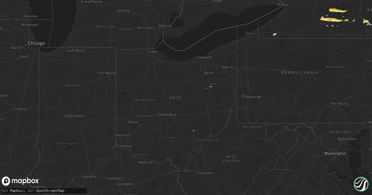
Hail Map in Ohio on June 5, 2025
Get this storm
June 5 map
$229
one time, instant access
Download today. No call, no setup
Keep the $229
Bought the map and want the full workflow? Apply the entire $229 to a subscription within 7 days. None of it is wasted.
Every map, not just this one
This buys you this map. Subscription and you get every map we run, in the markets you choose from a few cities to whole states to nationwide. Plus real-time alerts the moment a storm fires.
Contact data
Name, contact info, occupancy, even credit band for addresses in the footprint. You go from where it hit to who to call.
Become the source they trust
Unlimited branding weather history reports on demand. You already have the documented answer ready for the property owner, and you are the one who showed up with it.
Property data and RoofTrace estimates
Pull up any address you have got, its value and the exact code rules for that jurisdiction, straight from One Click Code. Then RoofTrace estimates the squares, pitch, and roof value, priced the way you price.
Storm reports in Ohio
Ohio
| Date | Description |
|---|---|
| 06/05/20254:31 PM CDT | Reports of a power pole and lines down near the train tracks and intersection of arbor road northeast and brussel road northeast. |
| 06/05/20254:30 PM CDT | County road 51 and county road 330 in northwestern holmes county were blocked due to fallen trees and power lines. Time was estimated by radar. |
| 06/05/20253:40 PM CDT | One tree down on ridge avenue. |
| 06/05/20253:38 PM CDT | One tree down on ridge avenue. |
All States Impacted by Hail Map on June 5, 2025
Cities Impacted by Hail Map on June 5, 2025
- Hereford, TX
- Canyon, TX
- Wildorado, TX
- Amarillo, TX
- Claude, TX
- Tulia, TX
- Happy, TX
- Dimmitt, TX
- Nazareth, TX
- Silverton, TX
- Graham, TX
- Pampa, TX
- Miami, TX
- Canadian, TX
- Stinnett, TX
- Borger, TX
- Briscoe, TX
- Reydon, OK
- Hedley, TX
- Farmington, NM
- Cheyenne, OK
- Jamestown, NY
- Falconer, NY
- Frewsburg, NY
- Hammon, OK
- Elk City, OK
- Kennedy, NY
- Texola, OK
- Balmorhea, TX
- Butler, OK
- Holly, CO
- Fort Davis, TX
- Sweetwater, OK
- Wheeler, TX
- Shamrock, TX
- Durham, OK
- Walsh, CO
- Two Buttes, CO
- Covington, TN
- Granada, CO
- Colorado Springs, CO
- Syracuse, KS
- Clinton, OK
- Canute, OK
- Sayre, OK
- Erick, OK
- Fort Stockton, TX
- Pecos, TX
- Glouster, OH
- Arapaho, OK
- Burlison, TN
- Foss, OK
- Corn, OK
- Manter, KS
- Weldona, CO
- Fort Morgan, CO
- Weatherford, OK
- Carter, OK
- Cohocton, NY
- Rushville, NY
- Stanley, NY
- Geneva, NY
- Penn Yan, NY
- Middlesex, NY
- Hydro, OK
- Colony, OK
- Prattsburgh, NY
- Beach City, OH
- Navarre, OH
- Bath, NY
- Avoca, NY
- Log Lane Village, CO
- Bellona, NY
- Lookeba, OK
- Binger, OK
- Hammondsport, NY
- Searchlight, NV
- Wayland, NY
- Atlanta, NY
- Johnson, KS
- Canton, OH
- East Sparta, OH
- Stanton, TN
- Hinton, OK
- Romulus, NY
- Ovid, NY
- Dresden, NY
- Pulteney, NY
- Branchport, NY
- Keuka Park, NY
- Elida, NM
- Pep, NM
- Portales, NM
- Floyd, NM
- Brush, CO
- Gracemont, OK
- Anadarko, OK
- Minco, OK
- Woodrow, CO
- Naples, NY
- Rogers, NM
- Dundee, NY
- Las Vegas, NV
- Rock Stream, NY
- Burdett, NY
- Canon City, CO
- Mentone, TX
- Hornell, NY
- Akron, CO
- Tuttle, OK
- Woodland, MS
- Aurora, NY
- King Ferry, NY
- Hector, NY
- Carlsbad, NM
- Ulysses, KS
- Maple, TX
- Causey, NM
- Loving, NM
- Newcastle, OK
- Blanchard, OK
- Savona, NY
- Coyanosa, TX
- Lindon, CO
- Morton, TX
- Sudan, TX
- Anton, CO
- Enochs, TX
- Branson, CO
- Moscow, KS
- Kim, CO
- Ninnekah, OK
- Chickasha, OK
- Bradford, NY
- Fort Sumner, NM
- Pyote, TX
- Barstow, TX
- Hugoton, KS
- Verden, OK
- Trumansburg, NY
- Ithaca, NY
- Jal, NM
- Overton, NV
- Artesia, NM
- Alex, OK
- Bradley, OK
- Lindsay, OK
- Interlaken, NY
- Melrose, NM
- Beaver Dams, NY
- Watkins Glen, NY
- Amber, OK
- Satanta, KS
- Cope, CO
- Arriba, CO
- Maljamar, NM
- Imperial, TX
- Muleshoe, TX
- Cement, OK
- Pep, TX
- Littlefield, TX
- Amherst, TX
- Taiban, NM
- House, NM
- Maysville, OK
- Purcell, OK
- Wink, TX
- Kermit, TX
- Springfield, CO
- Hobbs, NM
- Yellville, AR
- Lovington, NM
- Wayne, OK
- Pauls Valley, OK
- Paoli, OK
- Flagler, CO
- Freeville, NY
- Cannon Afb, NM
- Clovis, NM
- Mcalister, NM
- Houlton, ME
- Summit, AR
- Wynnewood, OK
- Levelland, TX
- Texico, NM
- Mcdonald, NM
- Tatum, NM
- Westfield, PA
- Tucumcari, NM
- Dryden, NY
- Stratford, OK
- Davis, OK
- Marathon, TX
- Seibert, CO
- Farwell, TX
- Marathon, NY
- Cincinnatus, NY
- Wellsboro, PA
- Gaines, PA
- Whitney Point, NY
- Alpine, TX
- Sublette, KS
- Willet, NY
- Smithville Flats, NY
- Anton, TX
- Vona, CO
- Ada, OK
- Sulphur, OK
- Roff, OK
- Greene, NY
- Shallowater, TX
- San Jon, NM
- Friona, TX
- McDonough, NY
- Mountain Home, AR
- Norfork, AR
- Oxford, NY
- Copeland, KS
- Plains, KS
- Lubbock, TX
- Chenango Forks, NY
- Bainbridge, NY
- Stratton, CO
- Fitzhugh, OK
- Stonewall, OK
- Mount Upton, NY
- Kit Carson, CO
- Montezuma, KS
- Meade, KS
- Guilford, NY
- Afton, NY
- Unadilla, NY
- Elkhart, KS
- Chester, OK
- La Junta, CO
- Seiling, OK
- Cheyenne Wells, CO
- Franklin, NY
- Sidney, NY
- Richfield, KS
- Ropesville, TX
- Wells Bridge, NY
- Wolfforth, TX
- Haswell, CO
- Eads, CO
- Otego, NY
- Sidney Center, NY
- Smyer, TX
- Whiteface, TX
- Slaton, TX
- Ransom Canyon, TX
- Idalou, TX
- Cleo Springs, OK
- Aline, OK
- Las Animas, CO
- Carmen, OK
- Delhi, NY
- Walton, NY
- Waynoka, OK
- Helena, OK
- Pritchett, CO
- Dacoma, OK
- Lorenzo, TX
- Fairview, OK
- Minneola, KS
- Crosbyton, TX
- Spur, TX
- Dryden, TX
- Sheridan Lake, CO
- Fieldton, TX
- Wilson, TX
- Norwich, NY
- Goltry, OK
- Jet, OK
- Cherokee, OK
- Nash, OK
- Ford, KS
- Oneonta, NY
- Ralls, TX
- Post, TX
- Baker, CA
- Bucklin, KS
- Justiceburg, TX
- Mullinville, KS
- Rolla, KS
- Campo, CO
- Vilas, CO
- Meno, OK
- Ringwood, OK
- Snyder, TX
- Lahoma, OK
- Enid, OK
- Carrier, OK
- Earth, TX
- Bovina, TX
- Waldron, KS
- Goodwell, OK
- Guymon, OK
- Jean, NV
- Felt, OK
- Dalhart, TX
- Paducah, TX
- Hooker, OK
- Turpin, OK
- Bovina Center, NY
- Englewood, KS
- Gate, OK
- Hardesty, OK
- Forgan, OK
- Beaver, OK
- Freedom, OK
- Balko, OK
- Perryton, TX
- Rosston, OK
- Ashland, KS
- Buffalo, OK
- Alva, OK
- Amorita, OK
- Booker, TX
- Hart, TX
- Springlake, TX
- Olton, TX
- Plainview, TX
- Kress, TX
- Mooreland, OK
- Wakita, OK
- Bluff City, KS
- Braman, OK
- Burlington, OK
- Manchester, OK
- Newkirk, OK
- Medford, OK
- Lipscomb, TX
- Higgins, TX
- Spearman, TX
- Arnett, OK
- Arkansas City, KS
- Sharon, OK
- Deer Creek, OK
- Blackwell, OK
- Hale Center, TX
- Shattuck, OK
- Gage, OK
- Fargo, OK
- Nardin, OK
- Lamont, OK
- Lockney, TX
- Vici, OK
- Camargo, OK
- Leedey, OK
- Taloga, OK
- Maple City, KS
- Hunter, OK
- Tonkawa, OK
- Kremlin, OK
- Pond Creek, OK
- Ponca City, OK
- Dexter, KS
- Red Rock, OK
- Billings, OK
- Shidler, OK
- Marland, OK
- Rolla, MO
- Bartlesville, OK
- Pawhuska, OK
- Pawnee, OK
- Ralston, OK
- Fairfax, OK
- Garber, OK
- Fairmont, OK
- Bison, OK
- Waukomis, OK
- Covington, OK
- Burbank, OK
- Wynona, OK
- Hominy, OK
- Isabella, OK
- Ames, OK
- Kingfisher, OK
- Loyal, OK
- Dover, OK
- Okarche, OK
- Omega, OK
- Hennessey, OK
- Cleveland, OK
- Crescent, OK
- Cashion, OK
- Guthrie, OK
- Osage, OK
- Maramec, OK
- Prue, OK
- Skiatook, OK
- Barnsdall, OK
- Sand Springs, OK
- Mulhall, OK
- Jennings, OK
- Coyle, OK
- Meridian, OK
- Wellston, OK
- Luther, OK
- Lucien, OK
- Vinita, OK
- Welch, OK
- Bluejacket, OK
- Delaware, OK
- Piedmont, OK
- Mannford, OK
- Terlton, OK
- Sperry, OK
- Tulsa, OK
- Collinsville, OK
- Owasso, OK
- Ramona, OK
- Vera, OK
- Talala, OK
- Oologah, OK
- Oklahoma City, OK
- Union City, OK
- Agra, OK
- Carney, OK
- Tryon, OK
- Mustang, OK
- Edmond, OK
- El Reno, OK
- Jones, OK
- Yukon, OK
- Arcadia, OK
- Drumright, OK
- Claremore, OK
- Catoosa, OK
- Kellyville, OK
- Sapulpa, OK
- Bristow, OK
- Norman, OK
- Park Hills, MO
- Mounds, OK
- Glenpool, OK
- Kiefer, OK
- Noble, OK
- Newalla, OK
- Jenks, OK
- Bixby, OK
- Fitchburg, MA
- Broken Arrow, OK
- Lexington, OK
- Boley, OK
- Paden, OK
- Castle, OK
- Eldorado, OK
- Chillicothe, TX
- Leominster, MA
- Wanette, OK
- Vernon, TX
- Macomb, OK
- Lunenburg, MA
- Haskell, OK
- Okemah, OK
- Byars, OK
- Morris, OK
- Okmulgee, OK
- Locust Grove, OK
- Peggs, OK
- Boynton, OK
- Shirley, MA
- Ayer, MA
- Devens, MA
- Lancaster, MA
- Asher, OK
- Council Hill, OK
- Harvard, MA
- Littleton, MA
- Groton, MA
- Muskogee, OK
- Taft, OK
- Oktaha, OK
- Eufaula, OK
- Checotah, OK
- Vian, OK
- Gore, OK
- North Las Vegas, NV
- Sterling, MA
- Canadian, OK
- Mcalester, OK
- Beggs, OK
- Porter, OK
- Weleetka, OK
- Henryetta, OK
- Stigler, OK
- Webbers Falls, OK
- Porum, OK
- Whitefield, OK
- Kinta, OK
- Red Oak, OK
- Keota, OK
- Bokoshe, OK
- Mccurtain, OK
- Wister, OK
- Wilburton, OK
- Quinton, OK
- Warner, OK
- Hanna, OK
- Indianola, OK
- Crowder, OK
- Dustin, OK
- Lamar, OK
- Holdenville, OK
- Wewoka, OK
- Wetumka, OK
- Seminole, OK
- Earlsboro, OK
- Shawnee, OK
- Prague, OK
- Meeker, OK
- Chandler, OK
- Sparks, OK
- Stroud, OK
- Davenport, OK
- Perkins, OK
- Cushing, OK
- Depew, OK
- Shady Point, OK
- Sallisaw, OK
- Braggs, OK
- Pocasset, OK
- Cordell, OK
- Mangum, OK
- Willow, OK
- Granite, OK
- Blair, OK
- Altus, OK
- Bessie, OK
- New Deal, TX
- Arapahoe, CO
- Fowler, KS
- Protection, KS
- Coldwater, KS
- Wilmore, KS
- Haviland, KS
- Girard, TX
- Tahoka, TX


