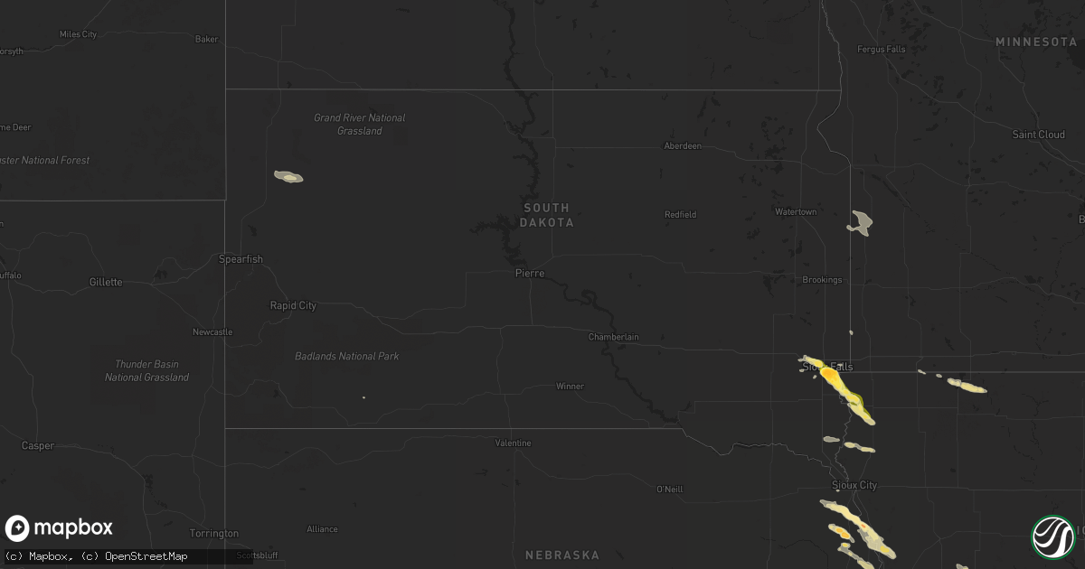
Hail Map in South Dakota on June 5, 2014
Get this storm
June 5 map
$229
one time, instant access
Download today. No call, no setup
Keep the $229
Bought the map and want the full workflow? Apply the entire $229 to a subscription within 7 days. None of it is wasted.
Every map, not just this one
This buys you this map. Subscription and you get every map we run, in the markets you choose from a few cities to whole states to nationwide. Plus real-time alerts the moment a storm fires.
Contact data
Name, contact info, occupancy, even credit band for addresses in the footprint. You go from where it hit to who to call.
Become the source they trust
Unlimited branding weather history reports on demand. You already have the documented answer ready for the property owner, and you are the one who showed up with it.
Property data and RoofTrace estimates
Pull up any address you have got, its value and the exact code rules for that jurisdiction, straight from One Click Code. Then RoofTrace estimates the squares, pitch, and roof value, priced the way you price.
Storm reports in South Dakota
South Dakota
| Date | Description |
|---|---|
| 06/05/20144:14 PM CDT | A local report indicates 1.00 inch wind near 3 SSW GARY |
| 06/05/20143:40 PM CDT | On ground along highway 11 |
| 06/05/20143:40 PM CDT | On ground along highway 11 north of 275th st |
| 06/05/20143:37 PM CDT | Near lake alvin |
| 06/05/20143:30 PM CDT | A local report indicates 2.00 inch wind near SIOUX FALLS |
| 06/05/20143:26 PM CDT | A local report indicates 1.50 inch wind near SIOUX FALLS |
| 06/05/20143:21 PM CDT | A local report indicates 1.75 inch wind near 4 S SIOUX FALLS |
| 06/05/20143:20 PM CDT | A local report indicates 1.25 inch wind near 4 S SIOUX FALLS |
| 06/05/20143:18 PM CDT | A local report indicates 1.25 inch wind near SIOUX FALLS |
| 06/05/20143:17 PM CDT | A local report indicates 2.00 inch wind near SIOUX FALLS |
| 06/05/20143:16 PM CDT | Nws employee reports 2 inch hail near 57th and cliff in sioux falls |
| 06/05/20143:14 PM CDT | A local report indicates 1.00 inch wind near SIOUX FALLS |
| 06/05/20143:10 PM CDT | Intersection of 1-229 and louise ave |
| 06/05/20143:09 PM CDT | Quarter size hail at 8th and summit in sioux falls |
| 06/05/20143:04 PM CDT | A local report indicates 1.00 inch wind near SIOUX FALLS |
| 06/05/20143:03 PM CDT | Quarter size hail at 12th and valley view in western sioux falls |
| 06/05/201412:45 AM CDT | Large farm equipment turned over and at least 12 inch diamature tree snapped off six feet above ground level. Driffts of pea size hail. |
| 06/05/201412:30 AM CDT | A local report indicates 60 MPH wind near HOOVER |
All States Impacted by Hail Map on June 5, 2014
Cities Impacted by Hail Map on June 5, 2014
- Amarillo, TX
- Delaware, OK
- Bluejacket, OK
- Vinita, OK
- Nowata, OK
- Lyons, NE
- Arriba, CO
- Balko, OK
- Erie, KS
- Chanute, KS
- Indian Hills, CO
- Evergreen, CO
- Kittredge, CO
- Matheson, CO
- Leonard, ND
- Stark, KS
- Elsmore, KS
- Hepler, KS
- Bronson, KS
- Moran, KS
- Redfield, KS
- Savonburg, KS
- Uniontown, KS
- Walnut, KS
- Karval, CO
- Haswell, CO
- Rushmore, MN
- Williamson, GA
- Brooks, GA
- Bois D Arc, MO
- Everton, MO
- Mount Vernon, MO
- Miller, MO
- Ash Grove, MO
- Springfield, MO
- Lone Wolf, OK
- Hobart, OK
- Adrian, TX
- Westport, TN
- Aiken, SC
- Jackson, SC
- Creswell, NC
- Rosalie, NE
- Bancroft, NE
- Eads, CO
- McClave, CO
- Tekamah, NE
- Craig, NE
- Mangum, OK
- Gould, OK
- Red Lake Falls, MN
- Crookston, MN
- Euclid, MN
- Laverne, OK
- Elizabeth, CO
- Castle Rock, CO
- Franktown, CO
- Fairfax, OK
- Waterloo, AL
- Bartlesville, OK
- Chinquapin, NC
- Wallace, NC
- Pawnee, OK
- Ramona, OK
- Skiatook, OK
- Collinsville, OK
- Shamrock, TX
- Wellington, TX
- Casselton, ND
- Wheatland, ND
- Douglas, OK
- Wildorado, TX
- Chouteau, OK
- Pryor, OK
- Inola, OK
- Elbert, CO
- Larkspur, CO
- Sioux Center, IA
- Rock Valley, IA
- Fort Scott, KS
- Huntingdon, TN
- Erick, OK
- Le Mars, IA
- Brunsville, IA
- Mountain Home, AR
- Midway, AR
- Buffalo, OK
- Eureka, KS
- Cherokee, AL
- Tuscumbia, AL
- Milledgeville, GA
- Gordon, GA
- McIntyre, GA
- Georgetown, SC
- Piedmont, AL
- Seven Springs, NC
- Neosho, MO
- Granby, MO
- Lexington, TN
- Wildersville, TN
- Honey Creek, IA
- Fort Calhoun, NE
- Missouri Valley, IA
- Newnan, GA
- Hardwick, MN
- Jasper, MN
- Luverne, MN
- Pulaski, TN
- Goodspring, TN
- Prospect, TN
- Fort Cobb, OK
- Gracemont, OK
- Anadarko, OK
- Ponca City, OK
- Independence, KS
- Ramah, CO
- Calhan, CO
- Quail, TX
- Morrison, CO
- Balaton, MN
- Ruthton, MN
- Hasty, CO
- Harrisburg, SD
- Oakes, ND
- Sweetwater, OK
- Texola, OK
- Wheeler, TX
- Sayre, OK
- Nara Visa, NM
- Sedalia, CO
- Sioux Falls, SD
- Groom, TX
- Savannah, TN
- Counce, TN
- Lawton, OK
- Elgin, OK
- Geronimo, OK
- Granite, OK
- Jonesboro, AR
- Paragould, AR
- Brookland, AR
- Fredonia, KS
- Longton, KS
- Elk City, KS
- Littleton, CO
- Englewood, CO
- Aurora, CO
- Sandersville, GA
- Altoona, KS
- Thayer, KS
- Benedict, KS
- Galesburg, KS
- Buffalo, KS
- Reeds, MO
- Manila, AR
- Onawa, IA
- Macy, NE
- Indiahoma, OK
- Sentinel, OK
- Havelock, NC
- Pender, NE
- New Bern, NC
- Rush, CO
- Nardin, OK
- Lamont, OK
- Hunter, OK
- Pond Creek, OK
- Tonkawa, OK
- Blackwell, OK
- Deer Creek, OK
- Pawhuska, OK
- Shidler, OK
- Little Sioux, IA
- Blencoe, IA
- Homer, NE
- Walthill, NE
- Emerson, NE
- Whiting, IA
- Winnebago, NE
- Decatur, NE
- Sloan, IA
- Pisgah, IA
- Hubbard, NE
- Galena, KS
- McCune, KS
- Baxter Springs, KS
- Oswego, KS
- Picher, OK
- Riverton, KS
- Chetopa, KS
- Columbus, KS
- Quapaw, OK
- Treece, KS
- Miami, OK
- Warren, MN
- Duncan, OK
- Estherville, IA
- Terril, IA
- Spirit Lake, IA
- Yoder, CO
- Bay, AR
- Trumann, AR
- Lake City, AR
- Cogswell, ND
- Arlington, NE
- Parker, CO
- Blounts Creek, NC
- Edward, NC
- Aurora, NC
- Yates Center, KS
- Carthage, MO
- Jasper, MO
- Glenwood, MN
- Starbuck, MN
- Forgan, OK
- Goodwell, OK
- Sugar City, CO
- Stella, MO
- Anderson, MO
- Middlesex, NC
- Zebulon, NC
- Green Forest, AR
- Black Rock, AR
- Smithville, AR
- Powhatan, AR
- Denver, CO
- Panhandle, TX
- Okoboji, IA
- Isabella, OK
- Ames, OK
- Drummond, OK
- Waukomis, OK
- Marland, OK
- Town Creek, AL
- Leighton, AL
- Muscle Shoals, AL
- Florence, AL
- Sheffield, AL
- Lenapah, OK
- Welch, OK
- Mason, TN
- Somerville, TN
- Elizabeth, AR
- Calico Rock, AR
- Dolph, AR
- Mosquero, NM
- Johnsonville, SC
- Gresham, SC
- Hanley Falls, MN
- Cottonwood, MN
- Manzanola, CO
- Olney Springs, CO
- Fowler, CO
- Goodman, MO
- Brownsville, TN
- Tracy, MN
- Currie, MN
- Lamar, MO
- Texhoma, OK
- Keyes, OK
- Wilson, NC
- Lucama, NC
- Phil Campbell, AL
- El Reno, OK
- May, OK
- Mapleton, ND
- Magnolia, NC
- Larchwood, IA
- Inwood, IA
- Fairview, SD
- Canton, SD
- Maurice, IA
- Hinton, OK
- Calumet, OK
- Hollywood, AL
- Glencoe, AR
- Camp, AR
- Ash Flat, AR
- Clarendon, TX
- Bono, AR
- White Deer, TX
- Cedar Vale, KS
- Fall River, KS
- Cambridge, KS
- Grenola, KS
- Howard, KS
- Peru, KS
- Sedan, KS
- Dexter, KS
- Moline, KS
- Elk Falls, KS
- Beech Bluff, TN
- Jackson, TN
- Sardis, GA
- Russellville, AL
- Claremore, OK
- Billings, OK
- Bennett, CO
- Kiowa, CO
- Simla, CO
- Agate, CO
- Deer Trail, CO
- Mclean, TX
- Conchas Dam, NM
- Trementina, NM
- Chandler, MN
- Lake Wilson, MN
- Slayton, MN
- Manns Harbor, NC
- Columbia, NC
- Stumpy Point, NC
- Fort Supply, OK
- Pinson, TN
- Bison, OK
- Carter, OK
- Willow, OK
- Ordway, CO
- Akron, IA
- Maple Hill, NC
- Richlands, NC
- Haddock, GA
- Peggs, OK
- Locust Grove, OK
- Harrisburg, AR
- Weiner, AR
- Bradford, TN
- Rutherford, TN
- Covington, TN
- Arma, KS
- Farlington, KS
- Arcadia, KS
- Limon, CO
- Arlington, CO
- Hugo, CO
- Flagler, CO
- Perry, OK
- Swansboro, NC
- Seligman, MO
- Mooreland, OK
- Goldsboro, NC
- Maysville, NC
- Pollocksville, NC
- Hemingway, SC
- Monett, MO
- La Russell, MO
- Sarcoxie, MO
- Stotts City, MO
- Halltown, MO
- Aurora, MO
- Pierce City, MO
- Brookline, MO
- Strafford, MO
- Wentworth, MO
- Walnut Grove, MO
- Billings, MO
- Republic, MO
- Willard, MO
- Marionville, MO
- Iola, KS
- Flippin, AR
- Yellville, AR
- Viola, AR
- Gepp, AR
- Chocowinity, NC
- Fargo, OK
- Binger, OK
- Union City, OK
- Lookeba, OK
- Minco, OK
- Section, AL
- Stark City, MO
- Hereford, TX
- Canyon, TX
- Vega, TX
- Claude, TX
- Colorado Springs, CO
- Ernul, NC
- Roseau, MN
- Badger, MN
- Cyril, OK
- Canby, MN
- Gary, SD
- Madison, MN
- Marietta, MN
- Folsom, NM
- Nesmith, SC
- Dill City, OK
- Turkey, NC
- Warsaw, NC
- Wyandotte, OK
- Fairland, OK
- Braman, OK
- Newkirk, OK
- Hedley, TX
- Oologah, OK
- Talala, OK
- Beaver, OK
- Newell, SD
- Clifton, TN
- Trinchera, CO
- Guymon, OK
- Ripley, TN
- Woodville, AL
- Scottsboro, AL
- Elmer, OK
- Dalhart, TX
- Batesville, AR
- Sulphur Rock, AR
- Seminole, TX
- Hobbs, NM
- Ava, MO
- Trinidad, CO
- Branson, CO
- Herman, NE
- Kennard, NE
- Blair, NE
- Kingfisher, OK
- Buchanan, GA
- Vinson, OK
- Spokane, MO
- Highlandville, MO
- Jacksonville, NC
- Beulaville, NC
- Seneca, MO
- Headrick, OK
- Omaha, NE
- Carter Lake, IA
- Council Bluffs, IA
- Gotebo, OK
- Toronto, KS
- Neodesha, KS
- Carnegie, OK
- Hydro, OK
- Beresford, SD
- Alcester, SD
- Elk Point, SD
- Powell, MO
- Pineville, MO
- Rocky Comfort, MO
- Washburn, MO
- Harrison, AR
- Russell, MN
- Altamont, KS
- Parsons, KS
- Cordell, OK
- Pampa, TX
- Macon, GA
- Gray, GA
- Sparta, MO
- Tabor City, NC
- Loris, SC
- Longs, SC
- Walnut Ridge, AR
- Beech Grove, AR
- Otter, MT
- Jackson, NE
- Enville, TN
- Henderson, TN
- Jacks Creek, TN
- Marshall, MN
- Scotts Hill, TN
- Danville, AL
- Belmont, MS
- New Site, MS
- Dennis, MS
- Tucumcari, NM
- Waynoka, OK
- Wann, OK
- Hooker, OK
- Minor Hill, TN
- Oakland, NE
- West Point, NE
- Modale, IA
- Crescent, IA
- Princeton, NC
- Fremont, NC
- La Grange, NC
- Kenly, NC
- Kinston, NC
- Pikeville, NC
- Stantonsburg, NC
- Kenansville, NC
- Ridgeland, SC
- Ralston, OK
- Faison, NC
- Hennepin, OK
- Davis, OK
- Clinton, NC
- Hitchcock, OK
- Eunice, NM
- Dyer, TN
- Garland, KS
- Mulberry, KS
- Franklin, KS
- Mindenmines, MO
- Liberal, MO
- Pittsburg, KS
- Girard, KS
- Humboldt, KS
- Oronogo, MO
- Cassville, MO
- Purdy, MO
- Hennessey, OK
- Bells, TN
- Walstonburg, NC
- Greenville, NC
- Fountain, NC
- Farmville, NC
- Follett, TX
- Bruceton, TN
- Pocasset, OK
- Tuttle, OK
- Amber, OK
- Humboldt, SD
- Hartford, SD
- Norfork, AR
- Diamond, MO
- S Coffeyville, OK
- Webb City, MO
- Mound Valley, KS
- Bartlett, KS
- Chelsea, OK
- Commerce, OK
- Carl Junction, MO
- Barnsdall, OK
- Carterville, MO
- North Miami, OK
- Hulbert, OK
- Joplin, MO
- Ochelata, OK
- Kaw City, OK
- Tiff City, MO
- Scammon, KS
- Burlison, TN
- Drummonds, TN
- Hollis, OK
- Bard, NM
- Cochran, GA
- Grimesland, NC
- Michie, TN
- Selmer, TN
- Guys, TN
- Mountain View, OK
- Cave Spring, GA
- Centre, AL
- Moscow, TN
- Tyler, MN
- Rhine, GA
- Pocahontas, AR
- Imboden, AR
- Wendell, NC
- Newton Grove, NC
- Roseboro, NC
- Nixa, MO
- Ozark, MO
- Laceys Spring, AL
- Lynd, MN
- Arco, MN
- Minneota, MN
- Ivanhoe, MN
- Apache, OK
- Marshall, OK
- Orlando, OK
- Sims, NC
- Benson, MN
- Walsh, CO
- Boise City, OK
- Porcupine, SD
- Nags Head, NC
- Cedartown, GA
- Andrews, SC
- Peyton, CO
- Severy, KS
- Cordova, TN
- Collierville, TN
- Eads, TN
- Ocheyedan, IA
- Worthington, MN
- Bigelow, MN
- Grantsboro, NC
- Oriental, NC
- Bayboro, NC
- Vanceboro, NC
- Vandemere, NC
- Merritt, NC
- Bon Aqua, TN
- Southaven, MS
- Trenton, NC
- Cherokee Village, AR
- Hardy, AR
- Pink Hill, NC
- Grove, OK
- Afton, OK
- Rentz, GA
- Cadwell, GA
- Dublin, GA
- Arapahoe, NC
- Grenville, NM
- Groveoak, AL
- Enid, OK
- Fairmont, OK
- Garber, OK
- Garita, NM
- Pineland, SC
- Toney, AL
- Luxora, AR
- Porter, MN
- Dallas, GA
- Decker, MT
- Bethel Springs, TN
- Adamsville, TN
- Salem, AR
- Bexar, AR
- Berryville, AR
- Eureka Springs, AR
- Mulhall, OK
- Dennis, KS
- Cherryvale, KS
- Coffeyville, KS
- Liberty, KS
- Shattuck, OK
- Gage, OK
- Fletcher, OK
- Duke, OK
- Audubon, IA
- Ninnekah, OK
- Rush Springs, OK
- Stillwater, OK
- Williford, AR
- Ravenden, AR
- Milford, IA
- Arnolds Park, IA
- Stantonville, TN
- Seibert, CO
- Gaylesville, AL
- Summerville, GA
- Mustang, OK
- Yukon, OK
- Tea, SD
- Cedar Bluff, AL
- Rome, GA
- Snow Hill, NC
- Stratford, TX
- Magnolia, MN
- Meansville, GA
- The Rock, GA
- Zebulon, GA
- Forsyth, GA
- Bronaugh, MO
- Deerfield, MO
- Blair, OK
- Altus, OK
- Clever, MO
- Winterville, NC
- Ayden, NC
- Silver Creek, GA
- Fort Sill, OK
- Faxon, OK
- Cache, OK
- Higdon, AL
- Flat Rock, AL
- Senoia, GA
- Bailey, NC
- Buffalo, ND
- Medford, OK
- Tipton, OK
- Dover, NC
- Fairview, TN
- Franklin, TN
- Marlow, OK
- Oklahoma City, OK
- Sharpsburg, GA
- Ridgeway, SC
- Walters, OK
- Foss, OK
- Canute, OK
- Hardesty, OK
- Ireton, IA
- Red Rock, OK
- Burbank, OK
- Morrison, OK
- Glencoe, OK
- Black Oak, AR
- Caraway, AR
- Paint Rock, AL
- Trenton, AL
- Cord, AR
- Newark, AR
- Cave City, AR
- Melbourne, AR
- Mount Pleasant, AR
- Charlotte, AR
- Gadsden, AL
- Fairmont, NC
- Nichols, SC
- San Jon, NM
- Edmond, OK
- Omaha, AR
- Hollister, MO
- Lampe, MO
- Oak Grove, AR
- Ridgedale, MO
- Alpena, AR
- Blue Eye, MO
- Lead Hill, AR
- Cedar Grove, TN
- Elmore City, OK
- Hills, MN
- Fort Payne, AL
- Cashion, OK
- Lake Park, IA
- Monument, CO
- Elkmont, AL
- Athens, AL
- Kenton, TN
- Trenton, TN
- Trezevant, TN
- McKenzie, TN
- Grifton, NC
- Toomsboro, GA
- Weir, KS
- Waynesboro, TN
- Olustee, OK
- Mountain Park, OK
- Snyder, OK
- Frederick, OK
- Adrian, MN
- Shiloh, TN
- Ramer, TN
- Piqua, KS
- Piedmont, KS
- Griffin, GA
- Ghent, MN
- Roosevelt, OK
- Salemburg, NC
- Copan, OK
- Burgaw, NC
- Las Vegas, NM
- Memphis, TN
- Arlington, TN
- Brandon, SD
- Bath Springs, TN
- Decaturville, TN
- Kimballton, IA
- Irwin, IA
- Eastman, GA
- Parker, SD
- Sardis, TN
- Woodward, OK
- Woodstock, MN
- Conway, SC
- Myrtle Beach, SC
- Huron, TN
- Tennille, GA
- Piedmont, OK
- Kimberling City, MO
- Shell Knob, MO
- Galena, MO
- Golden, MO
- Chickasha, OK
- Fordland, MO
- Bruner, MO
- Saint Paul, KS
- Belle Fourche, SD
- Buffalo, SD
- Poughkeepsie, AR
- Plainville, GA
- Denver City, TX
- Stella, NC
- Hubert, NC
- Morris Chapel, TN
- Calhoun, GA
- Adairsville, GA
- Swifton, AR
- Cash, AR
- Petersburg, TN
- South Greenfield, MO
- Blytheville, AR
- Armuchee, GA
- Humboldt, TN
- Gamaliel, AR
- Clarkridge, AR
- Tuckerman, AR
- Harris, IA
- Edna, KS
- Willard, NC
- Arkansas City, KS
- Manning, IA
- Kirkman, IA
- Macomb, MO
- Norwood, MO
- Crane, MO
- Roper, NC
- Plymouth, NC
- Manteo, NC
- Wanchese, NC
- Marion, SC
- Freedom, OK
- Monette, AR
- Sylvania, GA
- Brighton, TN
- Oakland, TN
- Peel, AR
- Golden, MS
- Finger, TN
- Allen, NE
- Newport, NC
- Emerald Isle, NC
- Ider, AL
- Pisgah, AL
- Colony, OK
- Loyal, OK
- Meno, OK
- Lahoma, OK
- Havana, KS
- Burden, KS
- Chautauqua, KS
- Altoona, AL
- Gallant, AL
- Attalla, AL
- Corn, OK
- Fayetteville, GA
- Concord, GA
- Barnesville, GA
- Crescent, OK
- Guthrie, OK
- Orrum, NC
- Murrells Inlet, SC
- Verona, MO
- Newport, AR
- Ratliff City, OK
- Leesburg, AL
- Gainesville, MO
- Cape Fair, MO
- Macclesfield, NC
- Fyffe, AL
- Hoxie, AR
- Mullins, SC
- Kennett, MO
- Keysville, GA
- Rockmart, GA
- Alva, OK
- Waynesboro, GA
- Blanchard, OK
- Iuka, MS
- Stanton, TN
- Trent, SD
- Lamar, CO
- La Harpe, KS
- Taunton, MN
- Clarkfield, MN
- Millen, GA
- Cherokee, KS
- Seymour, MO
- Rogersville, MO
- Jacksonville, AL
- Lake City, SC
- Palmetto, GA
- Doon, IA
- Little River, KS
- Hillsboro, KS
- Marion, KS
- Galva, KS
- Mcpherson, KS
- Canton, KS
- Lehigh, KS
- Windom, KS
- Lyons, KS
- Florence, KS
- Inman, KS
- Olmitz, KS
- Bison, KS
- Hudson, KS
- Rush Center, KS
- Ellinwood, KS
- Albert, KS
- Otis, KS
- Great Bend, KS
- Clearwater, KS
- Peck, KS
- Haysville, KS
- Moundridge, KS
- Rose Hill, KS
- Conway Springs, KS
- Mulvane, KS
- Mount Hope, KS
- Valley Center, KS
- Derby, KS
- Viola, KS
- Colwich, KS
- Augusta, KS
- Wellington, KS
- Andover, KS
- Goddard, KS
- Sedgwick, KS
- Maize, KS
- Andale, KS
- Mcconnell Afb, KS
- Kechi, KS
- Wichita, KS
- Belle Plaine, KS
- Douglass, KS


