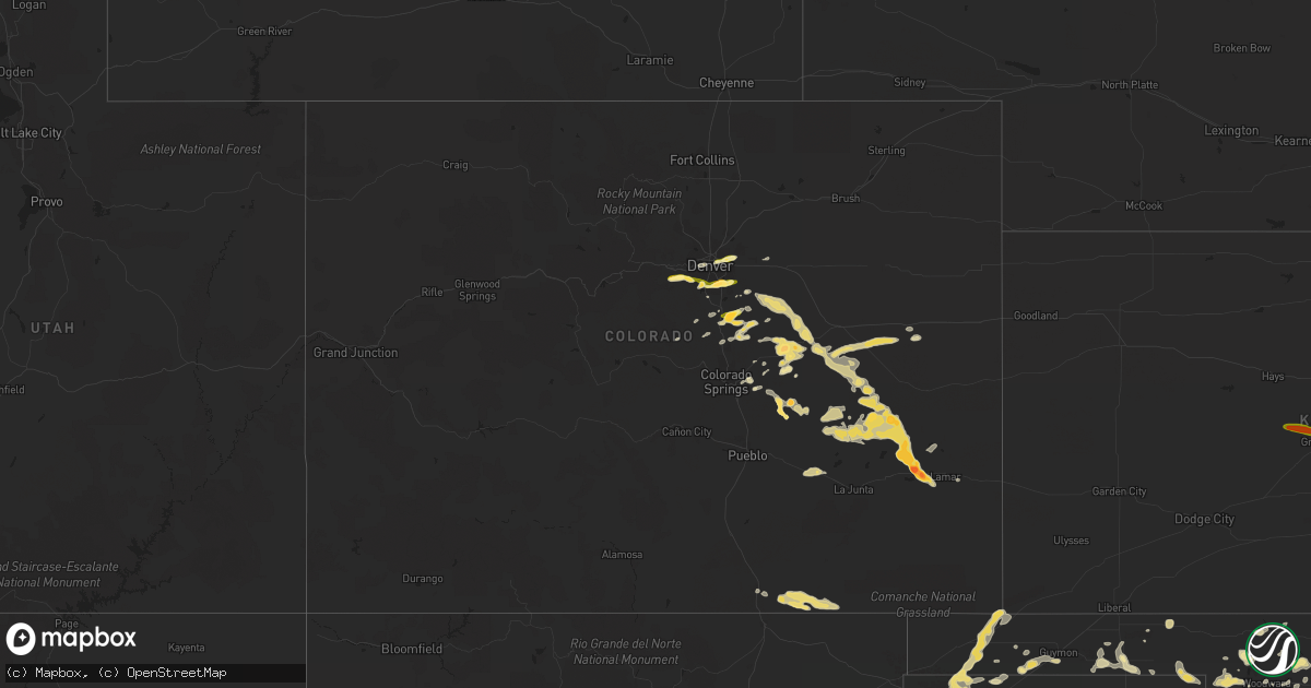
Hail Map in Colorado on June 5, 2014
Get this storm
June 5 map
$229
one time, instant access
Download today. No call, no setup
Keep the $229
Bought the map and want the full workflow? Apply the entire $229 to a subscription within 7 days. None of it is wasted.
Every map, not just this one
This buys you this map. Subscription and you get every map we run, in the markets you choose from a few cities to whole states to nationwide. Plus real-time alerts the moment a storm fires.
Contact data
Name, contact info, occupancy, even credit band for addresses in the footprint. You go from where it hit to who to call.
Become the source they trust
Unlimited branding weather history reports on demand. You already have the documented answer ready for the property owner, and you are the one who showed up with it.
Property data and RoofTrace estimates
Pull up any address you have got, its value and the exact code rules for that jurisdiction, straight from One Click Code. Then RoofTrace estimates the squares, pitch, and roof value, priced the way you price.
Storm reports in Colorado
Colorado
| Date | Description |
|---|---|
| 06/05/20146:50 PM CDT | A local report indicates 1.00 inch wind near 2 S LITTLETON |
| 06/05/20146:40 PM CDT | A local report indicates 1.50 inch wind near 3 NNW CHATFIELD RESERVO |
| 06/05/20146:23 PM CDT | A local report indicates 1.00 inch wind near 1 N KITTREDGE |
| 06/05/20146:09 PM CDT | A local report indicates 1.00 inch wind near 2 WNW CHATFIELD RESERVO |
| 06/05/20146:02 PM CDT | A local report indicates 1.25 inch wind near 1 NNW EVERGREEN |
| 06/05/20146:00 PM CDT | A local report indicates 1.25 inch wind near 1 NNE EVERGREEN |
| 06/05/20145:48 PM CDT | Time estimated based on radar. |
| 06/05/20145:28 PM CDT | A local report indicates 1.00 inch wind near TRINIDAD |
| 06/05/20144:13 PM CDT | A local report indicates 1.00 inch wind near 11 N KIOWA |
| 06/05/20144:00 PM CDT | A local report indicates 1.00 inch wind near 8 N KIOWA |
| 06/05/20143:38 PM CDT | A local report indicates 1.00 inch wind near 5 E PARKER |
| 06/05/20143:30 PM CDT | A local report indicates 1.00 inch wind near 5 E PARKER |
| 06/04/201411:30 PM CDT | Quarter-sized hail fell from approximately 1030 pm to 1040 pm mdt. |
| 06/04/201410:30 PM CDT | A local report indicates 2.50 inch wind near 17 S YODER |
| 06/04/201410:06 PM CDT | A local report indicates 2.00 inch wind near 13 W LAMAR |
| 06/04/20149:48 PM CDT | A local report indicates 1.00 inch wind near 1 NNE SCHRIEVER AFB |
| 06/04/20149:44 PM CDT | A local report indicates 1.00 inch wind near 1 NNE OLNEY SPRINGS |
| 06/04/20149:42 PM CDT | A local report indicates 1.00 inch wind near ENE OLNEY SPRINGS |
| 06/04/20149:42 PM CDT | A local report indicates 1.00 inch wind near 3 ENE ORDWAY |
| 06/04/20149:40 PM CDT | A local report indicates 1.00 inch wind near 3 ENE OLNEY SPRINGS |
| 06/04/20149:35 PM CDT | A local report indicates 1.00 inch wind near 5 N CALHAN |
| 06/04/20149:31 PM CDT | A local report indicates 1.00 inch wind near 2 N HASTY |
| 06/04/20149:28 PM CDT | A local report indicates 1.00 inch wind near MANZANOLA |
| 06/04/20149:19 PM CDT | A local report indicates 2.75 inch wind near 1 N HASTY |
| 06/04/20149:15 PM CDT | A local report indicates 1.00 inch wind near 5 NW SCHRIEVER AFB |
| 06/04/20149:09 PM CDT | A local report indicates 1.75 inch wind near 10 NW HASTY |
| 06/04/20149:05 PM CDT | A local report indicates a tornado near 1 W HASTY |
| 06/04/20149:00 PM CDT | Trailer blown over near elbert |
| 06/04/20148:54 PM CDT | A local report indicates 62 MPH wind near 6 W ELBERT |
| 06/04/20148:42 PM CDT | A local report indicates 1.00 inch wind near 10 SE HASWELL |
| 06/04/20148:41 PM CDT | A local report indicates 1.00 inch wind near 3 E CASTLE ROCK |
| 06/04/20148:40 PM CDT | A local report indicates 1.75 inch wind near 3 SE CASTLE ROCK |
| 06/04/20148:26 PM CDT | A local report indicates 1.75 inch wind near 4 SE HASWELL |
| 06/04/20148:08 PM CDT | Hail ranging in size from quarters to golf-balls...with quarter size hail ongoing. |
| 06/04/20147:54 PM CDT | A local report indicates 1.75 inch wind near 9 NW HASWELL |
| 06/04/20147:48 PM CDT | A local report indicates 1.00 inch wind near N RAMAH |
| 06/04/20147:46 PM CDT | Hail the size of quarters to golf balls began at approximately 636 pm mdt. |
| 06/04/20147:33 PM CDT | Hail ranging from the size of quarters to golf balls began at approximately 633 pm with large hail ongoing. |
| 06/04/20147:06 PM CDT | A local report indicates 1.00 inch wind near 1 NW CENTENNIAL |
| 06/04/20147:05 PM CDT | A local report indicates 1.00 inch wind near 5 SE ELBERT |
| 06/04/20147:04 PM CDT | Hail event lasted from 604-614 pm mdt. |
All States Impacted by Hail Map on June 5, 2014
Cities Impacted by Hail Map on June 5, 2014
- Amarillo, TX
- Delaware, OK
- Bluejacket, OK
- Vinita, OK
- Nowata, OK
- Lyons, NE
- Arriba, CO
- Balko, OK
- Erie, KS
- Chanute, KS
- Indian Hills, CO
- Evergreen, CO
- Kittredge, CO
- Matheson, CO
- Leonard, ND
- Stark, KS
- Elsmore, KS
- Hepler, KS
- Bronson, KS
- Moran, KS
- Redfield, KS
- Savonburg, KS
- Uniontown, KS
- Walnut, KS
- Karval, CO
- Haswell, CO
- Rushmore, MN
- Williamson, GA
- Brooks, GA
- Bois D Arc, MO
- Everton, MO
- Mount Vernon, MO
- Miller, MO
- Ash Grove, MO
- Springfield, MO
- Lone Wolf, OK
- Hobart, OK
- Adrian, TX
- Westport, TN
- Aiken, SC
- Jackson, SC
- Creswell, NC
- Rosalie, NE
- Bancroft, NE
- Eads, CO
- McClave, CO
- Tekamah, NE
- Craig, NE
- Mangum, OK
- Gould, OK
- Red Lake Falls, MN
- Crookston, MN
- Euclid, MN
- Laverne, OK
- Elizabeth, CO
- Castle Rock, CO
- Franktown, CO
- Fairfax, OK
- Waterloo, AL
- Bartlesville, OK
- Chinquapin, NC
- Wallace, NC
- Pawnee, OK
- Ramona, OK
- Skiatook, OK
- Collinsville, OK
- Shamrock, TX
- Wellington, TX
- Casselton, ND
- Wheatland, ND
- Douglas, OK
- Wildorado, TX
- Chouteau, OK
- Pryor, OK
- Inola, OK
- Elbert, CO
- Larkspur, CO
- Sioux Center, IA
- Rock Valley, IA
- Fort Scott, KS
- Huntingdon, TN
- Erick, OK
- Le Mars, IA
- Brunsville, IA
- Mountain Home, AR
- Midway, AR
- Buffalo, OK
- Eureka, KS
- Cherokee, AL
- Tuscumbia, AL
- Milledgeville, GA
- Gordon, GA
- McIntyre, GA
- Georgetown, SC
- Piedmont, AL
- Seven Springs, NC
- Neosho, MO
- Granby, MO
- Lexington, TN
- Wildersville, TN
- Honey Creek, IA
- Fort Calhoun, NE
- Missouri Valley, IA
- Newnan, GA
- Hardwick, MN
- Jasper, MN
- Luverne, MN
- Pulaski, TN
- Goodspring, TN
- Prospect, TN
- Fort Cobb, OK
- Gracemont, OK
- Anadarko, OK
- Ponca City, OK
- Independence, KS
- Ramah, CO
- Calhan, CO
- Quail, TX
- Morrison, CO
- Balaton, MN
- Ruthton, MN
- Hasty, CO
- Harrisburg, SD
- Oakes, ND
- Sweetwater, OK
- Texola, OK
- Wheeler, TX
- Sayre, OK
- Nara Visa, NM
- Sedalia, CO
- Sioux Falls, SD
- Groom, TX
- Savannah, TN
- Counce, TN
- Lawton, OK
- Elgin, OK
- Geronimo, OK
- Granite, OK
- Jonesboro, AR
- Paragould, AR
- Brookland, AR
- Fredonia, KS
- Longton, KS
- Elk City, KS
- Littleton, CO
- Englewood, CO
- Aurora, CO
- Sandersville, GA
- Altoona, KS
- Thayer, KS
- Benedict, KS
- Galesburg, KS
- Buffalo, KS
- Reeds, MO
- Manila, AR
- Onawa, IA
- Macy, NE
- Indiahoma, OK
- Sentinel, OK
- Havelock, NC
- Pender, NE
- New Bern, NC
- Rush, CO
- Nardin, OK
- Lamont, OK
- Hunter, OK
- Pond Creek, OK
- Tonkawa, OK
- Blackwell, OK
- Deer Creek, OK
- Pawhuska, OK
- Shidler, OK
- Little Sioux, IA
- Blencoe, IA
- Homer, NE
- Walthill, NE
- Emerson, NE
- Whiting, IA
- Winnebago, NE
- Decatur, NE
- Sloan, IA
- Pisgah, IA
- Hubbard, NE
- Galena, KS
- McCune, KS
- Baxter Springs, KS
- Oswego, KS
- Picher, OK
- Riverton, KS
- Chetopa, KS
- Columbus, KS
- Quapaw, OK
- Treece, KS
- Miami, OK
- Warren, MN
- Duncan, OK
- Estherville, IA
- Terril, IA
- Spirit Lake, IA
- Yoder, CO
- Bay, AR
- Trumann, AR
- Lake City, AR
- Cogswell, ND
- Arlington, NE
- Parker, CO
- Blounts Creek, NC
- Edward, NC
- Aurora, NC
- Yates Center, KS
- Carthage, MO
- Jasper, MO
- Glenwood, MN
- Starbuck, MN
- Forgan, OK
- Goodwell, OK
- Sugar City, CO
- Stella, MO
- Anderson, MO
- Middlesex, NC
- Zebulon, NC
- Green Forest, AR
- Black Rock, AR
- Smithville, AR
- Powhatan, AR
- Denver, CO
- Panhandle, TX
- Okoboji, IA
- Isabella, OK
- Ames, OK
- Drummond, OK
- Waukomis, OK
- Marland, OK
- Town Creek, AL
- Leighton, AL
- Muscle Shoals, AL
- Florence, AL
- Sheffield, AL
- Lenapah, OK
- Welch, OK
- Mason, TN
- Somerville, TN
- Elizabeth, AR
- Calico Rock, AR
- Dolph, AR
- Mosquero, NM
- Johnsonville, SC
- Gresham, SC
- Hanley Falls, MN
- Cottonwood, MN
- Manzanola, CO
- Olney Springs, CO
- Fowler, CO
- Goodman, MO
- Brownsville, TN
- Tracy, MN
- Currie, MN
- Lamar, MO
- Texhoma, OK
- Keyes, OK
- Wilson, NC
- Lucama, NC
- Phil Campbell, AL
- El Reno, OK
- May, OK
- Mapleton, ND
- Magnolia, NC
- Larchwood, IA
- Inwood, IA
- Fairview, SD
- Canton, SD
- Maurice, IA
- Hinton, OK
- Calumet, OK
- Hollywood, AL
- Glencoe, AR
- Camp, AR
- Ash Flat, AR
- Clarendon, TX
- Bono, AR
- White Deer, TX
- Cedar Vale, KS
- Fall River, KS
- Cambridge, KS
- Grenola, KS
- Howard, KS
- Peru, KS
- Sedan, KS
- Dexter, KS
- Moline, KS
- Elk Falls, KS
- Beech Bluff, TN
- Jackson, TN
- Sardis, GA
- Russellville, AL
- Claremore, OK
- Billings, OK
- Bennett, CO
- Kiowa, CO
- Simla, CO
- Agate, CO
- Deer Trail, CO
- Mclean, TX
- Conchas Dam, NM
- Trementina, NM
- Chandler, MN
- Lake Wilson, MN
- Slayton, MN
- Manns Harbor, NC
- Columbia, NC
- Stumpy Point, NC
- Fort Supply, OK
- Pinson, TN
- Bison, OK
- Carter, OK
- Willow, OK
- Ordway, CO
- Akron, IA
- Maple Hill, NC
- Richlands, NC
- Haddock, GA
- Peggs, OK
- Locust Grove, OK
- Harrisburg, AR
- Weiner, AR
- Bradford, TN
- Rutherford, TN
- Covington, TN
- Arma, KS
- Farlington, KS
- Arcadia, KS
- Limon, CO
- Arlington, CO
- Hugo, CO
- Flagler, CO
- Perry, OK
- Swansboro, NC
- Seligman, MO
- Mooreland, OK
- Goldsboro, NC
- Maysville, NC
- Pollocksville, NC
- Hemingway, SC
- Monett, MO
- La Russell, MO
- Sarcoxie, MO
- Stotts City, MO
- Halltown, MO
- Aurora, MO
- Pierce City, MO
- Brookline, MO
- Strafford, MO
- Wentworth, MO
- Walnut Grove, MO
- Billings, MO
- Republic, MO
- Willard, MO
- Marionville, MO
- Iola, KS
- Flippin, AR
- Yellville, AR
- Viola, AR
- Gepp, AR
- Chocowinity, NC
- Fargo, OK
- Binger, OK
- Union City, OK
- Lookeba, OK
- Minco, OK
- Section, AL
- Stark City, MO
- Hereford, TX
- Canyon, TX
- Vega, TX
- Claude, TX
- Colorado Springs, CO
- Ernul, NC
- Roseau, MN
- Badger, MN
- Cyril, OK
- Canby, MN
- Gary, SD
- Madison, MN
- Marietta, MN
- Folsom, NM
- Nesmith, SC
- Dill City, OK
- Turkey, NC
- Warsaw, NC
- Wyandotte, OK
- Fairland, OK
- Braman, OK
- Newkirk, OK
- Hedley, TX
- Oologah, OK
- Talala, OK
- Beaver, OK
- Newell, SD
- Clifton, TN
- Trinchera, CO
- Guymon, OK
- Ripley, TN
- Woodville, AL
- Scottsboro, AL
- Elmer, OK
- Dalhart, TX
- Batesville, AR
- Sulphur Rock, AR
- Seminole, TX
- Hobbs, NM
- Ava, MO
- Trinidad, CO
- Branson, CO
- Herman, NE
- Kennard, NE
- Blair, NE
- Kingfisher, OK
- Buchanan, GA
- Vinson, OK
- Spokane, MO
- Highlandville, MO
- Jacksonville, NC
- Beulaville, NC
- Seneca, MO
- Headrick, OK
- Omaha, NE
- Carter Lake, IA
- Council Bluffs, IA
- Gotebo, OK
- Toronto, KS
- Neodesha, KS
- Carnegie, OK
- Hydro, OK
- Beresford, SD
- Alcester, SD
- Elk Point, SD
- Powell, MO
- Pineville, MO
- Rocky Comfort, MO
- Washburn, MO
- Harrison, AR
- Russell, MN
- Altamont, KS
- Parsons, KS
- Cordell, OK
- Pampa, TX
- Macon, GA
- Gray, GA
- Sparta, MO
- Tabor City, NC
- Loris, SC
- Longs, SC
- Walnut Ridge, AR
- Beech Grove, AR
- Otter, MT
- Jackson, NE
- Enville, TN
- Henderson, TN
- Jacks Creek, TN
- Marshall, MN
- Scotts Hill, TN
- Danville, AL
- Belmont, MS
- New Site, MS
- Dennis, MS
- Tucumcari, NM
- Waynoka, OK
- Wann, OK
- Hooker, OK
- Minor Hill, TN
- Oakland, NE
- West Point, NE
- Modale, IA
- Crescent, IA
- Princeton, NC
- Fremont, NC
- La Grange, NC
- Kenly, NC
- Kinston, NC
- Pikeville, NC
- Stantonsburg, NC
- Kenansville, NC
- Ridgeland, SC
- Ralston, OK
- Faison, NC
- Hennepin, OK
- Davis, OK
- Clinton, NC
- Hitchcock, OK
- Eunice, NM
- Dyer, TN
- Garland, KS
- Mulberry, KS
- Franklin, KS
- Mindenmines, MO
- Liberal, MO
- Pittsburg, KS
- Girard, KS
- Humboldt, KS
- Oronogo, MO
- Cassville, MO
- Purdy, MO
- Hennessey, OK
- Bells, TN
- Walstonburg, NC
- Greenville, NC
- Fountain, NC
- Farmville, NC
- Follett, TX
- Bruceton, TN
- Pocasset, OK
- Tuttle, OK
- Amber, OK
- Humboldt, SD
- Hartford, SD
- Norfork, AR
- Diamond, MO
- S Coffeyville, OK
- Webb City, MO
- Mound Valley, KS
- Bartlett, KS
- Chelsea, OK
- Commerce, OK
- Carl Junction, MO
- Barnsdall, OK
- Carterville, MO
- North Miami, OK
- Hulbert, OK
- Joplin, MO
- Ochelata, OK
- Kaw City, OK
- Tiff City, MO
- Scammon, KS
- Burlison, TN
- Drummonds, TN
- Hollis, OK
- Bard, NM
- Cochran, GA
- Grimesland, NC
- Michie, TN
- Selmer, TN
- Guys, TN
- Mountain View, OK
- Cave Spring, GA
- Centre, AL
- Moscow, TN
- Tyler, MN
- Rhine, GA
- Pocahontas, AR
- Imboden, AR
- Wendell, NC
- Newton Grove, NC
- Roseboro, NC
- Nixa, MO
- Ozark, MO
- Laceys Spring, AL
- Lynd, MN
- Arco, MN
- Minneota, MN
- Ivanhoe, MN
- Apache, OK
- Marshall, OK
- Orlando, OK
- Sims, NC
- Benson, MN
- Walsh, CO
- Boise City, OK
- Porcupine, SD
- Nags Head, NC
- Cedartown, GA
- Andrews, SC
- Peyton, CO
- Severy, KS
- Cordova, TN
- Collierville, TN
- Eads, TN
- Ocheyedan, IA
- Worthington, MN
- Bigelow, MN
- Grantsboro, NC
- Oriental, NC
- Bayboro, NC
- Vanceboro, NC
- Vandemere, NC
- Merritt, NC
- Bon Aqua, TN
- Southaven, MS
- Trenton, NC
- Cherokee Village, AR
- Hardy, AR
- Pink Hill, NC
- Grove, OK
- Afton, OK
- Rentz, GA
- Cadwell, GA
- Dublin, GA
- Arapahoe, NC
- Grenville, NM
- Groveoak, AL
- Enid, OK
- Fairmont, OK
- Garber, OK
- Garita, NM
- Pineland, SC
- Toney, AL
- Luxora, AR
- Porter, MN
- Dallas, GA
- Decker, MT
- Bethel Springs, TN
- Adamsville, TN
- Salem, AR
- Bexar, AR
- Berryville, AR
- Eureka Springs, AR
- Mulhall, OK
- Dennis, KS
- Cherryvale, KS
- Coffeyville, KS
- Liberty, KS
- Shattuck, OK
- Gage, OK
- Fletcher, OK
- Duke, OK
- Audubon, IA
- Ninnekah, OK
- Rush Springs, OK
- Stillwater, OK
- Williford, AR
- Ravenden, AR
- Milford, IA
- Arnolds Park, IA
- Stantonville, TN
- Seibert, CO
- Gaylesville, AL
- Summerville, GA
- Mustang, OK
- Yukon, OK
- Tea, SD
- Cedar Bluff, AL
- Rome, GA
- Snow Hill, NC
- Stratford, TX
- Magnolia, MN
- Meansville, GA
- The Rock, GA
- Zebulon, GA
- Forsyth, GA
- Bronaugh, MO
- Deerfield, MO
- Blair, OK
- Altus, OK
- Clever, MO
- Winterville, NC
- Ayden, NC
- Silver Creek, GA
- Fort Sill, OK
- Faxon, OK
- Cache, OK
- Higdon, AL
- Flat Rock, AL
- Senoia, GA
- Bailey, NC
- Buffalo, ND
- Medford, OK
- Tipton, OK
- Dover, NC
- Fairview, TN
- Franklin, TN
- Marlow, OK
- Oklahoma City, OK
- Sharpsburg, GA
- Ridgeway, SC
- Walters, OK
- Foss, OK
- Canute, OK
- Hardesty, OK
- Ireton, IA
- Red Rock, OK
- Burbank, OK
- Morrison, OK
- Glencoe, OK
- Black Oak, AR
- Caraway, AR
- Paint Rock, AL
- Trenton, AL
- Cord, AR
- Newark, AR
- Cave City, AR
- Melbourne, AR
- Mount Pleasant, AR
- Charlotte, AR
- Gadsden, AL
- Fairmont, NC
- Nichols, SC
- San Jon, NM
- Edmond, OK
- Omaha, AR
- Hollister, MO
- Lampe, MO
- Oak Grove, AR
- Ridgedale, MO
- Alpena, AR
- Blue Eye, MO
- Lead Hill, AR
- Cedar Grove, TN
- Elmore City, OK
- Hills, MN
- Fort Payne, AL
- Cashion, OK
- Lake Park, IA
- Monument, CO
- Elkmont, AL
- Athens, AL
- Kenton, TN
- Trenton, TN
- Trezevant, TN
- McKenzie, TN
- Grifton, NC
- Toomsboro, GA
- Weir, KS
- Waynesboro, TN
- Olustee, OK
- Mountain Park, OK
- Snyder, OK
- Frederick, OK
- Adrian, MN
- Shiloh, TN
- Ramer, TN
- Piqua, KS
- Piedmont, KS
- Griffin, GA
- Ghent, MN
- Roosevelt, OK
- Salemburg, NC
- Copan, OK
- Burgaw, NC
- Las Vegas, NM
- Memphis, TN
- Arlington, TN
- Brandon, SD
- Bath Springs, TN
- Decaturville, TN
- Kimballton, IA
- Irwin, IA
- Eastman, GA
- Parker, SD
- Sardis, TN
- Woodward, OK
- Woodstock, MN
- Conway, SC
- Myrtle Beach, SC
- Huron, TN
- Tennille, GA
- Piedmont, OK
- Kimberling City, MO
- Shell Knob, MO
- Galena, MO
- Golden, MO
- Chickasha, OK
- Fordland, MO
- Bruner, MO
- Saint Paul, KS
- Belle Fourche, SD
- Buffalo, SD
- Poughkeepsie, AR
- Plainville, GA
- Denver City, TX
- Stella, NC
- Hubert, NC
- Morris Chapel, TN
- Calhoun, GA
- Adairsville, GA
- Swifton, AR
- Cash, AR
- Petersburg, TN
- South Greenfield, MO
- Blytheville, AR
- Armuchee, GA
- Humboldt, TN
- Gamaliel, AR
- Clarkridge, AR
- Tuckerman, AR
- Harris, IA
- Edna, KS
- Willard, NC
- Arkansas City, KS
- Manning, IA
- Kirkman, IA
- Macomb, MO
- Norwood, MO
- Crane, MO
- Roper, NC
- Plymouth, NC
- Manteo, NC
- Wanchese, NC
- Marion, SC
- Freedom, OK
- Monette, AR
- Sylvania, GA
- Brighton, TN
- Oakland, TN
- Peel, AR
- Golden, MS
- Finger, TN
- Allen, NE
- Newport, NC
- Emerald Isle, NC
- Ider, AL
- Pisgah, AL
- Colony, OK
- Loyal, OK
- Meno, OK
- Lahoma, OK
- Havana, KS
- Burden, KS
- Chautauqua, KS
- Altoona, AL
- Gallant, AL
- Attalla, AL
- Corn, OK
- Fayetteville, GA
- Concord, GA
- Barnesville, GA
- Crescent, OK
- Guthrie, OK
- Orrum, NC
- Murrells Inlet, SC
- Verona, MO
- Newport, AR
- Ratliff City, OK
- Leesburg, AL
- Gainesville, MO
- Cape Fair, MO
- Macclesfield, NC
- Fyffe, AL
- Hoxie, AR
- Mullins, SC
- Kennett, MO
- Keysville, GA
- Rockmart, GA
- Alva, OK
- Waynesboro, GA
- Blanchard, OK
- Iuka, MS
- Stanton, TN
- Trent, SD
- Lamar, CO
- La Harpe, KS
- Taunton, MN
- Clarkfield, MN
- Millen, GA
- Cherokee, KS
- Seymour, MO
- Rogersville, MO
- Jacksonville, AL
- Lake City, SC
- Palmetto, GA
- Doon, IA
- Little River, KS
- Hillsboro, KS
- Marion, KS
- Galva, KS
- Mcpherson, KS
- Canton, KS
- Lehigh, KS
- Windom, KS
- Lyons, KS
- Florence, KS
- Inman, KS
- Olmitz, KS
- Bison, KS
- Hudson, KS
- Rush Center, KS
- Ellinwood, KS
- Albert, KS
- Otis, KS
- Great Bend, KS
- Clearwater, KS
- Peck, KS
- Haysville, KS
- Moundridge, KS
- Rose Hill, KS
- Conway Springs, KS
- Mulvane, KS
- Mount Hope, KS
- Valley Center, KS
- Derby, KS
- Viola, KS
- Colwich, KS
- Augusta, KS
- Wellington, KS
- Andover, KS
- Goddard, KS
- Sedgwick, KS
- Maize, KS
- Andale, KS
- Mcconnell Afb, KS
- Kechi, KS
- Wichita, KS
- Belle Plaine, KS
- Douglass, KS


