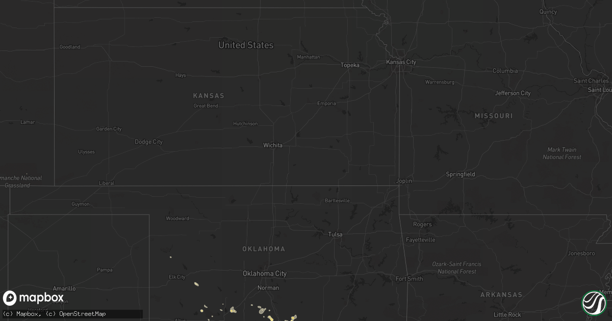
Hail Map in Montana on June 5, 2012
Get this storm
June 5 map
$229
one time, instant access
Download today. No call, no setup
Keep the $229
Bought the map and want the full workflow? Apply the entire $229 to a subscription within 7 days. None of it is wasted.
Every map, not just this one
This buys you this map. Subscription and you get every map we run, in the markets you choose from a few cities to whole states to nationwide. Plus real-time alerts the moment a storm fires.
Contact data
Name, contact info, occupancy, even credit band for addresses in the footprint. You go from where it hit to who to call.
Become the source they trust
Unlimited branding weather history reports on demand. You already have the documented answer ready for the property owner, and you are the one who showed up with it.
Property data and RoofTrace estimates
Pull up any address you have got, its value and the exact code rules for that jurisdiction, straight from One Click Code. Then RoofTrace estimates the squares, pitch, and roof value, priced the way you price.
Storm reports in Montana
Montana
| Date | Description |
|---|---|
| 06/05/20126:50 PM CDT | Estimated 1.0 inch hail with rotation in se corner of wall cloud |
| 06/05/20126:48 PM CDT | 90 mph wind gust in hobson |
| 06/05/20126:41 PM CDT | Tornado spotted on the ground with damage |
| 06/05/20126:41 PM CDT | Large garage flattened |
| 06/05/20126:30 PM CDT | Golf ball size hail reported by trained spotter |
| 06/05/20126:00 PM CDT | Hail up to walnut size in the holter lake area. |
| 06/05/20125:17 PM CDT | Hail measued at 2.0 inches |
| 06/05/20124:50 PM CDT | A local report indicates 1.00 inch wind near WHITE SULPHUR SPRINGS |
| 06/05/20124:44 PM CDT | Sheriff office reports golf ball size hail in white sulphur springs falling at the sheriff office. |
| 06/04/20128:58 PM CDT | A local report indicates 1.25 inch wind near 8 W BIG SANDY |
| 06/04/20128:33 PM CDT | Report of tree damage and a tree that fell onto a house |
| 06/04/20128:33 PM CDT | Spotter confirmed cone tornado approx 8 miles sse of big sandy |
| 06/04/20127:55 PM CDT | Estimated 1.0 inch plus size hail |
| 06/04/20127:53 PM CDT | Local law enforcement confirmed tornado on ground with large path and damage |
| 06/04/20127:18 PM CDT | Estimated golf ball size hail with funnel cloud observed |
| 06/04/20127:00 PM CDT | A local report indicates 1.00 inch wind near 4 NNE WINDHAM |
All States Impacted by Hail Map on June 5, 2012
Cities Impacted by Hail Map on June 5, 2012
- Junction, TX
- Coffee Creek, MT
- Denton, MT
- Neihart, MT
- Monarch, MT
- Geraldine, MT
- Hale Center, TX
- Abernathy, TX
- Cordele, GA
- Danville, GA
- Jeffersonville, GA
- Cochran, GA
- Logansport, LA
- Colorado City, TX
- Loraine, TX
- Fargo, GA
- Lake City, FL
- Forest Hill, LA
- Roff, OK
- Sulphur, OK
- Orlando, FL
- Windermere, FL
- Hobson, MT
- Marshall, TX
- Richmond Hill, GA
- Townsend, MT
- Toston, MT
- Sonora, TX
- Chester, MT
- Clarksville, TX
- Quincy, FL
- Valdosta, GA
- Moody Afb, GA
- Lakeland, GA
- Ray City, GA
- Naylor, GA
- Hahira, GA
- Stockton, GA
- Homerville, GA
- Du Pont, GA
- Wolf Creek, MT
- Ringling, MT
- Dexter, GA
- Rentz, GA
- Cadwell, GA
- Petersburg, TX
- Idalou, TX
- Loma, MT
- Big Sandy, MT
- Hermleigh, TX
- Sweetwater, TX
- Roscoe, TX
- Stanford, MT
- Moccasin, MT
- Laredo, TX
- Pitts, GA
- Vienna, GA
- Sterling City, TX
- Glennville, GA
- Soperton, GA
- Gail, TX
- Chauncey, GA
- McRae Helena, GA
- Eastman, GA
- Falfurrias, TX
- Post, TX
- Pelican, LA
- Big Spring, TX
- Hawley, TX
- Plainview, TX
- Lubbock, TX
- Lorenzo, TX
- Slaton, TX
- Martinsdale, MT
- Rhine, GA
- Geyser, MT
- Raynesford, MT
- Belt, MT
- Floydada, TX
- Jefferson, GA
- Minden, LA
- Bristol, GA
- Mershon, GA
- Bagwell, TX
- Valliant, OK
- Augusta, MT
- Grand Cane, LA
- Mansfield, LA
- White Sulphur Springs, MT
- Collinsville, TX
- Whitesboro, TX
- Howe, TX
- Montrose, GA
- Statham, GA
- Winder, GA
- Ville Platte, LA
- Oakdale, LA
- Lindsay, OK
- Fletcher, OK
- Thomasville, GA
- Ralls, TX
- Broxton, GA
- West Green, GA
- Guerra, TX
- Hebbronville, TX
- Patterson, GA
- Alma, GA
- Screven, GA
- Jena, LA
- Trout, LA
- Riceboro, GA
- Midway, GA
- Strasburg, ND
- Vidalia, GA
- Ailey, GA
- Pineville, LA
- Alexandria, LA
- Wichita Falls, TX
- Milton, FL
- Justin, TX
- Fort Worth, TX
- Crosbyton, TX
- Plaucheville, LA
- Texarkana, AR
- Bunkie, LA
- Homestead, FL
- Groveland, FL
- Brunswick, GA
- Tulia, TX
- Two Dot, MT
- Choteau, MT
- Muenster, TX
- Saint Jo, TX
- Nocona, TX
- Hilliard, FL
- Loxley, AL
- Robertsdale, AL
- Stapleton, AL
- Bay Minette, AL
- Sulphur Springs, TX
- Callahan, FL
- Jacksonville, FL
- Coahoma, TX
- Maysville, OK
- Pauls Valley, OK
- Belgrade, MT
- Uvalda, GA
- Lumber City, GA
- Odum, GA
- Surrency, GA
- Hazlehurst, GA
- Baxley, GA
- Wright City, OK
- Idabel, OK
- Broken Bow, OK
- Avery, TX
- Garvin, OK
- Valier, MT
- Belle Rose, LA
- Westbrook, TX
- Clermont, FL
- Reidsville, GA
- Blackwell, TX
- Rudyard, MT
- Inverness, MT
- Fort Benton, MT
- Highwood, MT
- Hennepin, OK
- Encino, TX
- Concepcion, TX
- Marksville, LA
- Macon, GA
- Elgin, OK
- Fairfield, MT
- Homer, LA
- Daphne, AL
- Valley Spring, TX
- Abbeville, GA
- Rochelle, GA
- Shreveport, LA
- Coushatta, LA
- Gainesville, TX
- Sanger, TX
- Maitland, FL
- Winter Park, FL
- Casselberry, FL
- Brady, TX
- Lohn, TX
- Pavo, GA
- Dry Branch, GA
- Marshallville, GA
- Reynolds, GA
- Boston, GA
- Barney, GA
- Floweree, MT
- Carter, MT
- Webster, FL
- Ozona, TX
- Winter Garden, FL
- Gillette, WY
- Carthage, TX
- Ludowici, GA
- Buffalo, MT
- Fort Davis, TX
- Odonnell, TX
- Perry, GA
- Chester, GA
- Dudley, GA
- Dublin, GA
- Wynnewood, OK
- Marathon, TX
- Rocksprings, TX
- Fort Valley, GA
- Whitlash, MT
- Joplin, MT
- Maryneal, TX
- Mountain View, OK
- Cumby, TX
- Brashear, TX
- Fort Stockton, TX
- Elmore City, OK
- Jayton, TX
- Aspermont, TX
- Jacksonville, GA
- Ada, OK
- Stratford, OK
- Indiahoma, OK
- Naples, FL
- Ochopee, FL
- Haughton, LA
- Doyline, LA
- Wakpala, SD
- Rochelle, TX
- Converse, LA
- Wilson, TX
- Butler, GA
- Ball, LA
- Realitos, TX
- Benton, LA
- Belcher, LA
- Jesup, GA
- Sapelo Island, GA
- Darien, GA
- Hammon, OK
- Brady, MT
- Lyons, GA
- Glenwood, GA
- Alamo, GA
- Tallahassee, FL
- Pollock, LA
- Evergreen, LA
- Hortense, GA
- Waynesville, GA
- Defuniak Springs, FL
- Fitzgerald, GA
- Tchula, MS
- Edinburg, TX
- Hingham, MT
- Saint Simons Island, GA
- Boyce, LA
- Ringling, OK
- Snyder, TX
- Fluvanna, TX
- Cordell, OK
- Roosevelt, OK
- Pittsview, AL
- Foster, OK
- Bossier City, LA
- Richland, GA
- Fairhope, AL
- Silverhill, AL
- Milan, GA
- Denton, GA
- Rebecca, GA
- Spur, TX
- Byromville, GA
- Montezuma, GA
- Florala, AL
- Ringold, OK
- Dubberly, LA
- Sibley, LA
- Townsend, GA
- Detroit, TX
- Cyril, OK
- Titusville, FL
- Christoval, TX
- Jefferson, TX
- Vivian, LA
- West Point, GA
- Glenmora, LA
- Mount Vernon, GA
- Frierson, LA
- Troy, AL
- Morven, GA
- Quitman, GA
- Collins, GA
- Junction City, GA
- Gildford, MT
- Campo, CO
- London, TX
- Mobile, AL
- Ponce De Leon, FL
- Molino, FL
- McDavid, FL
- Hinesville, GA
- Tarrytown, GA
- Roby, TX
- Merkel, TX
- Jonesville, LA
- Wilson, OK
- Grant, OK
- Tahoka, TX
- Douglas, GA
- Big Timber, MT
- Jay, FL
- Baker, FL
- Pollock, SD
- Menard, TX
- Montverde, FL
- Apache, OK
- Era, TX
- Marianna, FL
- Greenwood, FL
- Monterey, LA
- Apopka, FL
- Bentley, LA
- Elmer, LA
- Gloster, LA
- Stonewall, LA
- Keatchie, LA
- Davis, OK
- Durant, OK
- Caddo, OK
- Elm Grove, LA
- Omaha, GA
- Adel, GA
- Tishomingo, OK
- Stonewall, OK
- Zellwood, FL
- Dixie, GA
- Barwick, GA
- Lecompte, LA
- Lockney, TX
- Bozeman, MT
- Mauk, GA
- Box Springs, GA
- Oviedo, FL
- Lumpkin, GA
- Ninnekah, OK
- Bradley, OK
- Alex, OK
- Pitkin, LA
- Elizabeth, LA
- Jekyll Island, GA
- Claxton, GA
- Allenhurst, GA
- Irwinton, GA
- Lady Lake, FL
- Fruitland Park, FL
- Donalsonville, GA
- Iron City, GA
- Nahunta, GA
- Pontotoc, TX
- Llano, TX
- Leslie, GA
- De Soto, GA
- Fort Mitchell, AL
- Effie, LA
- Grand Ridge, FL
- Sneads, FL
- Voca, TX
- Broadus, MT
- Pleasant Hill, LA
- Immokalee, FL
- Bronte, TX
- Olton, TX
- Byron, GA
- Waverly Hall, GA
- Woodland, GA
- Houma, LA
- Hawkinsville, GA
- Pineview, GA
- Drake, CO
- Cobb, GA
- Lawton, OK


