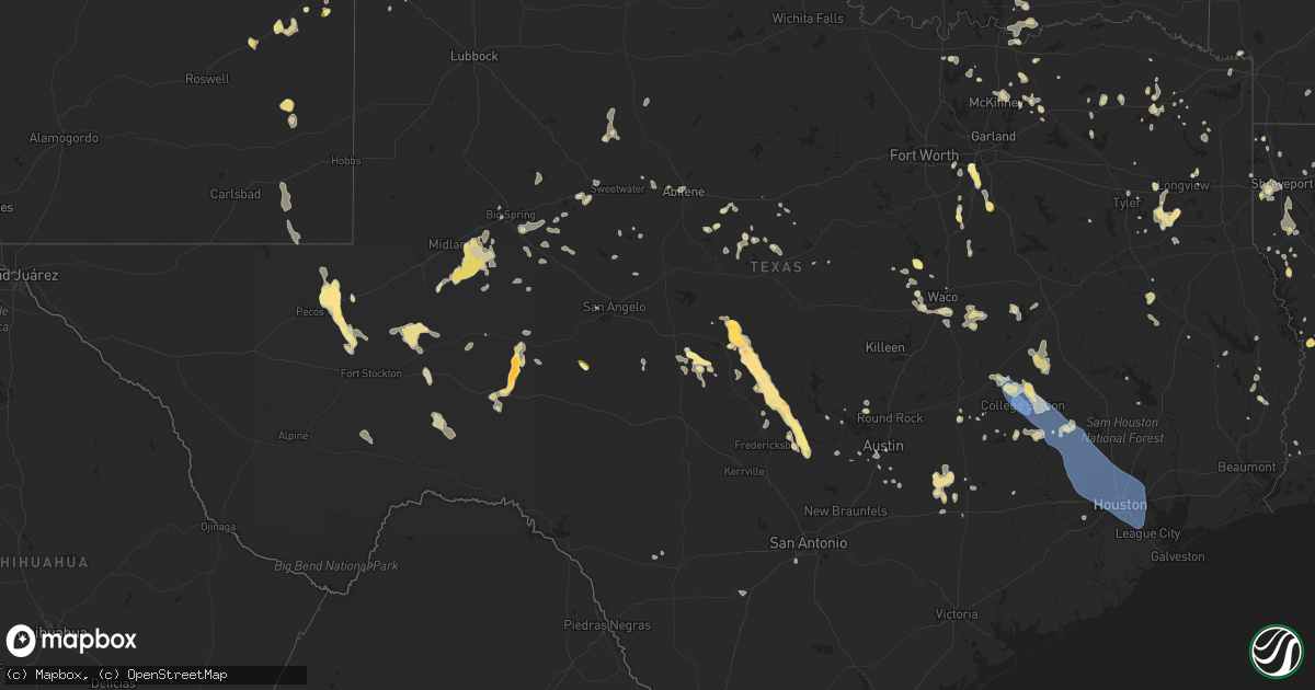
Hail Map in Texas on June 3, 2023
Get this storm
June 3 map
$229
one time, instant access
Download today. No call, no setup
Keep the $229
Bought the map and want the full workflow? Apply the entire $229 to a subscription within 7 days. None of it is wasted.
Every map, not just this one
This buys you this map. Subscription and you get every map we run, in the markets you choose from a few cities to whole states to nationwide. Plus real-time alerts the moment a storm fires.
Contact data
Name, contact info, occupancy, even credit band for addresses in the footprint. You go from where it hit to who to call.
Become the source they trust
Unlimited branding weather history reports on demand. You already have the documented answer ready for the property owner, and you are the one who showed up with it.
Property data and RoofTrace estimates
Pull up any address you have got, its value and the exact code rules for that jurisdiction, straight from One Click Code. Then RoofTrace estimates the squares, pitch, and roof value, priced the way you price.
Storm reports in Texas
Texas
| Date | Description |
|---|---|
| 06/03/20236:59 PM CDT | A local report indicates 1.00 inch wind near Bovina |
| 06/03/20236:14 PM CDT | A local report indicates 1.00 inch wind near 10 NW Eldorado |
| 06/03/20236:05 PM CDT | A few trees down... Limbs... Etc. Largest hail ping pong sized along highway 29 north of castell. Time estimated via radar. |
| 06/03/20236:05 PM CDT | A few trees down... Limbs... Etc. Largest hail ping pong sized along highway 29 north of castell. Time estimated via radar. |
| 06/03/20235:35 PM CDT | A local report indicates 2.00 inch wind near 4 WNW Pontotoc |
| 06/03/20234:02 PM CDT | 52kt or 60 mph wind gust measured at the gregg county airport in longview... Texas. |
| 06/03/20234:01 PM CDT | 50kt or 58 mph wind gust measured at the gregg county airport in longview... Texas. |
| 06/03/20233:50 PM CDT | Numerous trees downed across the northern half of rusk county or between kilgore and henderson... Texas. |
| 06/03/20233:49 PM CDT | A tree was downed across highway 8 south of douglassville. |
| 06/03/20233:49 PM CDT | A tree was downed across cr 1601 near avinger. |
| 06/03/20233:45 PM CDT | A local report indicates 1.00 inch wind near 0.25 W Placid |
| 06/03/20233:40 PM CDT | Corrects previous hail report from 2 wsw placid. |
| 06/03/20231:28 PM CDT | Several trees snapped and uprooted south of alto... Texas along cr 2707. |
| 06/03/202311:30 AM CDT | Gas station awning knocked down. |
| 06/03/20231:45 AM CDT | Brick facade of the mlk center in the third ward was blown off due to winds. |
| 06/03/20231:40 AM CDT | Multiple large trees uprooted and fallen branches along allen parkway between studemont st and sabine st. |
| 06/03/20231:37 AM CDT | Asos station kiah houston intnl. |
| 06/03/20231:37 AM CDT | Bush intercontinental airport asos station measured 62 mph wind gust. |
| 06/03/20231:35 AM CDT | Houston dunn asos station measured 59 mph wind gust. |
| 06/03/20231:20 AM CDT | A local report indicates 60 MPH wind near 2 NNE San Angelo |
| 06/03/202312:45 AM CDT | Numerous large branches downed across the city of magnolia. |
| 06/03/202312:23 AM CDT | Law enforcement dispatch reported multiple downed trees throughout the county. |
| 06/03/202312:06 AM CDT | Ew4261 mesonet site measured 69 mph wind gust. |
| 06/02/202311:50 PM CDT | Large tree limbs downed and blocking the street on ennis street. |
| 06/02/202311:50 PM CDT | Large tree limbs downed and blocking the street on ennis street. |
| 06/02/202311:50 PM CDT | Corrects previous tstm wnd gst report from 1 ese bryan. Large tree limbs downed and blocking the street on ennis street. |
| 06/02/202311:45 PM CDT | Large tree knocked down due to winds onto a mobile home. |
| 06/02/202311:40 PM CDT | Dispatch reports trees down near iola due to thunderstorm winds. |
| 06/02/202311:40 PM CDT | Kyle field mesonet site measured 85 mph wind gust. |
| 06/02/202311:40 PM CDT | Brick facade of an apartment complex was taken off due to winds. |
| 06/02/202311:30 PM CDT | Corrects previous tstm wnd dmg report from 2 ne up429. Gas station awning knocked down. |
| 06/02/202311:30 PM CDT | Gas station awning knocked down. Several trees blown down in the college station area. |
| 06/02/202311:30 PM CDT | Corrects time from previous tstm wnd dmg report from 2 ne up429. Gas station awning knocked down. Several trees blown down in the college station area. |
| 06/02/202311:20 PM CDT | Asos station kcll easterwood field airport. |
| 06/02/202311:20 PM CDT | Mesonet station 1757w texas a&m kyle field. |
| 06/02/202311:20 PM CDT | Asos station kcll eas |
| 06/02/202310:52 PM CDT | Tree down blocking the westbound lane on state highway 159 before it becomes state highway 237 around 5 miles to the east-northeast of la grange. |
| 06/02/20239:43 PM CDT | West texas mesonet |
| 06/02/20239:09 PM CDT | 59 mph thunderstorm wind gusts measured at austin bergstrom international airport. |
| 06/02/20238:58 PM CDT | Gas station canopy partially destroyed. Time estimated from radar. |
| 06/02/20238:54 PM CDT | A local report indicates 2.50 inch wind near 22 NW Ozona |
| 06/02/20238:41 PM CDT | Report from mping: ping pong ball |
| 06/02/20238:30 PM CDT | Report of quarter |
| 06/02/20238:29 PM CDT | Report from mping: half dollar |
| 06/02/20238:22 PM CDT | Tree damage with 6-foot branch breaking off an oak tree. Small tree also was snapped in half. Near the intersection of duck lake dr. And palos verdes drive. Time estima |
| 06/02/20238:17 PM CDT | Golf ball sized hail reported near fm2575 east of amarillo. |
| 06/02/20238:17 PM CDT | Co-op observer sent pictures of power pole down and large tree blown over on property. Approximate time given by observer and matched with radar. |
| 06/02/20238:15 PM CDT | Report from mping: half dollar |
| 06/02/20238:12 PM CDT | Half dollar sized hail observed near highland park via social media. |
| 06/02/20237:45 PM CDT | Public reported estimated ping pong size hail on fm 3167 in rio grande city with picture on social media. Time estimated from radar. |
| 06/02/20237:44 PM CDT | Trained spotter reported pea to nickel size hail with a few quarters mixed in 2 s of laguna park. |
| 06/02/20237:07 PM CDT | Reports of marble to quarter size hail in northern desoto. |
| 06/02/20237:04 PM CDT | Quarter size hail reported approx 8 miles south of wildorado relayed by local media. |
| 06/02/20237:00 PM CDT | Quarter sized hail reported southwest of hereford. |
All States Impacted by Hail Map on June 3, 2023
Cities Impacted by Hail Map on June 3, 2023
- Bradford, NH
- Hillsborough, NH
- Hollywood, FL
- Dania, FL
- Fort Lauderdale, FL
- Lake Worth, FL
- Boynton Beach, FL
- Lake Worth Beach, FL
- Apple Springs, TX
- Accident, MD
- Grantsville, MD
- Booneville, AR
- Siloam Springs, AR
- Watts, OK
- Miami, FL
- Waldron, AR
- Oakland, MD
- Vinita, OK
- Miami Gardens, FL
- Paris, AR
- West Jordan, UT
- Salt Lake City, UT
- Midvale, UT
- Lake Ariel, PA
- Lakeville, PA
- Greentown, PA
- Newfoundland, PA
- Sterling, PA
- Moscow, PA
- Ada, OK
- South Sterling, PA
- Gouldsboro, PA
- Rochelle, TX
- Portales, NM
- Pickerel, WI
- Pearson, WI
- Brady, TX
- Milton, PA
- Northumberland, PA
- Winfield, PA
- Selinsgrove, PA
- Shamokin Dam, PA
- Sunbury, PA
- Middleburg, PA
- Mount Pleasant Mills, PA
- Freeburg, PA
- Richfield, PA
- Canonsburg, PA
- Washington, PA
- Marshall, MI
- Albion, MI
- Millerstown, PA
- McAlisterville, PA
- Thompsontown, PA
- San Saba, TX
- Nemacolin, PA
- Carmichaels, PA
- Greensboro, PA
- Rogers, NM
- Homer, MI
- Newport, PA
- Voca, TX
- Pontotoc, TX
- Menard, TX
- Roswell, NM
- Valley Spring, TX
- Castell, TX
- Llano, TX
- Melvin, TX
- Shamokin, PA
- Pitman, PA
- Leck Kill, PA
- Hegins, PA
- Valley View, PA
- Klingerstown, PA
- Sacramento, PA
- Lykens, PA
- Wiconisco, PA
- Spring Glen, PA
- Williamstown, PA
- Halifax, PA
- Williamsburg, PA
- Alexandria, PA
- Hollidaysburg, PA
- Hereford, TX
- Morgan City, LA
- Livingston, LA
- Tower City, PA
- Grantville, PA
- Harrisburg, PA
- Eldorado, TX
- Plymouth, IN
- New Salem, PA
- Loysville, PA
- Landisburg, PA
- Funk, NE
- Axtell, NE
- Shawano, WI
- Gibbon, NE
- Vulcan, MI
- Altamont, KS
- Parsons, KS
- Omaha, TX
- Cookville, TX
- Maxwell, NE
- Hooks, TX
- Commodore, PA
- Cherry Tree, PA
- Magnolia, AR
- Minden, LA
- Summers, AR
- Lincoln, AR
- Fayetteville, AR
- Sedan, KS
- Pittsburg, OK
- Stringtown, OK
- Glenville, WV
- Redbird, OK
- Porter, OK
- Ashdown, AR
- Fayetteville, WV
- Beavertown, PA
- Pennsboro, WV
- Fort Smith, AR
- Greenwood, AR
- West Fork, AR
- Dalmatia, PA
- Markleysburg, PA
- Canada, KY
- Elida, NM
- Bingham Canyon, UT
- Winslow, AR
- Naples, TX
- Hatfield, AR
- Virgil, KS
- Belcher, LA
- Lewisburg, PA
- Mifflinburg, PA
- New Berlin, PA
- Pocola, OK
- Shreveport, LA
- Greenwood, LA
- Linden, TX
- Simsboro, LA
- Tatum, NM
- Jonesboro, LA
- Mansfield, LA
- Frierson, LA
- Grand Cane, LA
- Hughes Springs, TX
- Tupelo, OK
- Hackett, AR
- Leonard, TX
- Trenton, TX
- Keithville, LA
- Montandon, PA
- Caddo Gap, AR
- Okemah, OK
- Natural Dam, AR
- Tyler, TX
- Whitehouse, TX
- Troup, TX
- Anacoco, LA
- Leesville, LA
- Vivian, LA
- Madill, OK
- Laneville, TX
- Huntington, IN
- Warren, IN
- Xenia, OH
- Wickes, AR
- Abilene, KS
- Greenville, TX
- Gainesville, TX
- Converse, LA
- Gladewater, TX
- Clay Center, KS
- Caddo, OK
- Alexandria, LA
- Pineville, LA
- Lecompte, LA
- Kenefic, OK
- Oswego, KS
- Adair, OK
- Big Cabin, OK
- Lansing, WV
- Victor, WV
- Yantis, TX
- Emory, TX
- Foster City, MI
- Mount Pleasant, TX
- Winfield, TX
- Lena, LA
- Cloutierville, LA
- Call, TX
- Kirbyville, TX
- Middlebourne, WV
- Friendly, WV
- Saint Marys, WV
- Sistersville, WV
- New Matamoras, OH
- Mcalester, OK
- Clearfield, PA
- Crystal Falls, MI
- Dierks, AR
- Durant, OK
- Bokchito, OK
- Mineral Point, PA
- Johnstown, PA
- Lufkin, TX
- Weleetka, OK
- Price, TX
- Arp, TX
- Overton, TX
- Henderson, TX
- Selman City, TX
- Kilgore, TX
- Oberlin, LA
- Kinder, LA
- Elizabeth, WV
- Muldrow, OK
- Colbert, OK
- Calera, OK
- Hendrix, OK
- Denison, TX
- Liverpool, PA
- Alto, TX
- Wells, TX
- Delaware, OK
- Swanton, MD
- McHenry, MD
- Wilson, KS
- Buna, TX
- Proctor, OK
- Elkins, AR
- Clymer, PA
- Starford, PA
- Rosston, AR
- Ozark, AR
- Hallsville, TX
- West Union, WV
- Pompano Beach, FL
- Avinger, TX
- Sulphur Springs, TX
- Dike, TX
- Arcadia, LA
- Dulac, LA
- Lavaca, AR
- Saint Gabriel, LA
- Sunshine, LA
- Phyllis, KY
- Kimper, KY
- Prescott, AR
- Princeton, LA
- Dixonville, PA
- Oakdale, LA
- Waldo, KS
- Russell, KS
- Dorrance, KS
- Bunker Hill, KS
- Jasper, TX
- Buckner, AR
- Stamps, AR
- Dustin, OK
- Stonewall, OK
- Caney, OK
- Milburn, OK
- Coleman, OK
- Ragley, LA
- East Waterford, PA
- Blairs Mills, PA
- Bluejacket, OK
- Arkoma, OK
- Spiro, OK
- Roland, OK
- Cameron, OK
- Edon, OH
- Hamilton, IN
- Ardmore, OK
- Harlem, MT
- Hays, MT
- Dequincy, LA
- Cedar Valley, UT
- Bonham, TX
- Vinton, LA
- Eighty Four, PA
- Savoy, TX
- Bells, TX
- Alma, WV
- Salem, WV
- Jefferson, TX
- Daisy, OK
- Tishomingo, OK
- Hallandale, FL
- Starks, LA
- Rose, OK
- Amherstdale, WV
- Kearney, NE
- Combs, AR
- Saint Paul, AR
- Waynesburg, PA
- Jefferson, PA
- Daingerfield, TX
- Farmington, AR
- Petroleum, WV
- Cairo, WV
- Athens, LA
- Bienville, LA
- Gibsland, LA
- Woodston, KS
- Lohn, TX
- Richland Springs, TX
- Saltillo, TX
- Sulphur Bluff, TX
- Fort Stockton, TX
- Amity, PA
- Chapman, KS
- Chester, AR
- Tahlequah, OK
- Mannsville, OK
- Mill Creek, OK
- Alma, AR
- Rudy, AR
- Pittsford, MI
- Osseo, MI
- Strang, OK
- Smithville, OK
- Mena, AR
- Talco, TX
- Webster Springs, WV
- Pickens, WV
- Wapanucka, OK
- Grannis, AR
- Roff, OK
- Wolfe City, TX
- McNeil, AR
- Brady, NE
- Pineland, TX
- Karnack, TX
- Mooringsport, LA
- Marion Center, PA
- Madison, KS
- Toronto, KS
- Leesburg, TX
- Pittsburg, TX
- Spavinaw, OK
- Barling, AR
- Charleston, AR
- Majestic, KY
- Matewan, WV
- Kirby, AR
- Kennard, TX
- Sherman, TX
- Benton, LA
- Colmesneil, TX
- Marathon, TX
- Kaplan, LA
- Maurice, LA
- Baton Rouge, LA
- Plaquemine, LA
- West Salisbury, PA
- Springs, PA
- Salisbury, PA
- Westover, PA
- La Jose, PA
- Emerson, AR
- Williamson, WV
- Belfry, KY
- Ebensburg, PA
- Bluffton, IN
- Theriot, LA
- Lookout, WV
- Edmond, WV
- Hawkins, TX
- West Valley City, UT
- Wharncliffe, WV
- Sycamore, PA
- Moran, KS
- Elton, LA
- Pitkin, LA
- Elizabeth, LA
- Prosperity, PA
- Hosston, LA
- Ida, LA
- Robeline, LA
- Marthaville, LA
- Terry, MS
- Enterprise, KS
- Olpe, KS
- Clarksville, TX
- Delray Beach, FL
- Bethel Park, PA
- Pittsburgh, PA
- Scroggins, TX
- Haughton, LA
- Dallas, TX
- Desoto, TX
- Lancaster, TX
- Willow City, TX
- Fredericksburg, TX
- Round Mountain, TX
- Johnson City, TX
- Friona, TX
- Summerfield, TX
- Clovis, NM
- Texico, NM
- Farwell, TX
- Bovina, TX
- Lemoyne, PA
- New Cumberland, PA
- Camp Hill, PA
- Mechanicsburg, PA
- Lewisberry, PA
- Dillsburg, PA
- Panhandle, TX
- Wildorado, TX
- Red Oak, TX
- Hye, TX
- Rio Grande City, TX
- Roma, TX
- Blanco, TX
- Clifton, TX
- Valley Mills, TX
- Ozona, TX
- Amarillo, TX
- Ennis, TX
- Italy, TX
- Milford, TX
- Grandview, TX
- Pyote, TX
- Barstow, TX
- Pecos, TX
- Coyanosa, TX
- Bryan, TX
- Hearne, TX
- College Station, TX
- Navasota, TX
- Iola, TX
- Anderson, TX
- Midlothian, TX
- New Holland, OH
- Mount Sterling, OH
- Waco, TX
- Walker, WV
- Axton, VA
- Eden, NC
- Cascade, VA
- Farmersville, TX
- Elkhart, IN
- Crawford, TX
- McGregor, TX
- Henderson, WV
- Gallipolis Ferry, WV
- Point Pleasant, WV
- Liberty, WV
- Given, WV
- Leon, WV
- Waxahachie, TX
- Denham Springs, LA
- Pine Grove, LA
- Greenwell Springs, LA
- Clinton, LA
- Broken Arrow, OK
- Tulsa, OK
- Tioga, TX
- Pilot Point, TX
- Anna, TX
- Big Lake, TX
- Doylesburg, PA
- Lilly, PA
- Maypearl, TX
- Monahans, TX
- Garden City, TX
- Stanton, TX
- Grand Prairie, TX
- Amherst, TX
- Portage, PA
- Sidman, PA
- Lovington, NM
- Mishawaka, IN
- Osceola, IN
- Encino, NM
- Malone, TX
- Mertens, TX
- Hubbard, TX
- Imperial, TX
- Princeton, TX
- Mckinney, TX
- Melissa, TX
- Raymond, MS
- Tyrone, PA
- Midland, TX
- South Webster, OH
- Crane, TX
- Celeste, TX
- Coal Township, PA
- Elysburg, PA
- Paxinos, PA
- Rebuck, PA
- Dornsife, PA
- Sicily Island, LA
- Ferriday, LA
- Smithville, TX
- Pride, LA
- Slaughter, LA
- Zachary, LA
- Roxie, MS
- Natchez, MS
- Spicewood, TX
- Amite, LA
- Walker, LA
- Holden, LA
- Man, WV
- Gallipolis, OH
- Napoleonville, LA
- Belle Rose, LA
- Garards Fort, PA
- Bay Saint Louis, MS
- Huntsville, TX
- Oakhurst, TX
- Newport, OH
- Leander, TX
- Perkinston, MS
- Riesel, TX
- Marlin, TX
- McCamey, TX
- McHenry, MS
- Breaux Bridge, LA
- Southside, WV
- Lorena, TX
- Hewitt, TX
- Artesia, NM
- Trevorton, PA
- Art, TX
- Pine Grove, PA
- Bloomsburg, PA
- Meyersdale, PA
- Celina, TX
- Liberty Center, IN
- Markle, IN
- Friendsville, MD
- Austin, TX
- Thornton, TX
- Groesbeck, TX
- Midkiff, TX
- Enola, PA
- Jonestown, PA
- Danville, VA
- Mason, TX
- Stonewall, TX
- Wink, TX
- Tekonsha, MI
- Nappanee, IN
- Guyton, GA
- High Point, NC
- Melrose, NM
- Pierre Part, LA
- Pelican, LA
- Loving, NM
- Carlsbad, NM
- Gresham, WI
- Green, KS
- Jal, NM
- Stokesdale, NC
- Tobyhanna, PA
- Stoneville, NC
- Clarklake, MI
- Jerome, MI
- Cement City, MI
- Horton, MI
- Herndon, PA
- Pampa, TX
- Hagerman, NM
- Duncanville, TX
- Dry Fork, VA
- Dermott, AR
- Cedar Hill, TX
- Tullos, LA
- Jeanerette, LA
- Florien, LA
- Crystal Springs, MS
- Palmer, TX
- Saucier, MS
- Donie, TX
- Addison, MI
- Driftwood, TX
- Caddo Mills, TX
- Zapata, TX
- San Angelo, TX
- Liberty Hill, TX
- Marble Falls, TX
- Blue Ridge, TX
- Pearlington, MS
- Hornbeck, LA
- Dripping Springs, TX
- Eden, TX
- Hext, TX
- Valley View, TX
- Gratz, PA
- Horseshoe Bay, TX
- Larue, TX
- Collinsville, TX
- Prairieville, LA
- Palmer, KS
- Manchaca, TX
- Plantersville, TX
- Waller, TX
- Montgomery, TX
- Magnolia, TX
- Hockley, TX
- Hempstead, TX
- Cypress, TX
- Tomball, TX
- Pinehurst, TX
- Katy, TX
- Houston, TX
- Bellaire, TX
- Spring, TX
- Friendswood, TX
- Webster, TX
- South Houston, TX
- Pasadena, TX
- Pearland, TX
- Galena Park, TX
- Deer Park, TX
- La Porte, TX
- Humble, TX
- Channelview, TX
- Porter, TX
- Conroe, TX
- Glenshaw, PA
- Big Spring, TX
- Petersburg, PA
- Buda, TX
- Colorado City, TX
- Summerhill, PA
- Pearsall, TX
- Caldwell, TX
- Tulia, TX
- Shubuta, MS
- Loretto, PA
- Roscoe, TX
- Sterling City, TX
- Muldoon, TX
- La Grange, TX
- Happy, TX
- Masontown, PA
- Ronco, PA
- Laredo, TX
- Sudan, TX
- Dryden, TX
- Labadieville, LA
- Independence, LA
- French Settlement, LA
- Uvalde, TX
- Kiln, MS
- Picayune, MS
- Marietta, OH
- Mcalister, NM
- Richmond, TX
- Chilton, TX
- Schulenburg, TX
- Cabins, WV
- Petersburg, WV
- Lexington, TX
- Ira, TX
- Coahoma, TX
- Lockhart, TX
- Franklin, LA
- Groom, TX
- Flatonia, TX
- San Ygnacio, TX
- West Point, TX
- Von Ormy, TX
- Canyon, TX
- Cat Spring, TX
- New Ulm, TX
- Washington, TX
- Brenham, TX
- Loraine, TX
- Claude, TX
- Rotan, TX
- Kosse, TX
- Robert Lee, TX
- Mirando City, TX
- Somerville, TX
- Bastrop, TX
- Giddings, TX
- House, NM
- Waveland, MS
- Falfurrias, TX
- Abbeville, LA
- Gibson, LA
- Thibodaux, LA
- Berwick, LA
- Patterson, LA
- Normangee, TX
- North Zulch, TX
- Westbrook, TX
- Aspermont, TX
- Opa Locka, FL
- Dale, TX
- Realitos, TX
- Madisonville, TX
- Marquez, TX
- Franklin, TX
- Coldspring, TX
- Pass Christian, MS
- Rockdale, TX
- Abilene, TX
- Cross Plains, TX
- Rising Star, TX
- Brownwood, TX
- Baird, TX
- Clyde, TX
- Gorman, TX
- De Leon, TX
- Garita, NM
- Cuervo, NM
- Conchas Dam, NM
- Old Glory, TX
- Gustine, TX
- Carlton, TX
- Miles, TX
- Bronte, TX
- Merkel, TX
- May, TX
- Blanket, TX
- Sidney, TX
- Vaughn, NM
- Blackwell, TX
- Grady, NM
- Eastland, TX
- Muleshoe, TX
- Trent, TX
- Garciasville, TX
- Fredonia, TX
- Wingate, TX
- Coleman, TX
- Burkett, TX
- Cisco, TX
- Carbon, TX
- Home, PA
- Spruce Creek, PA
- Altoona, PA
- Ernest, PA


