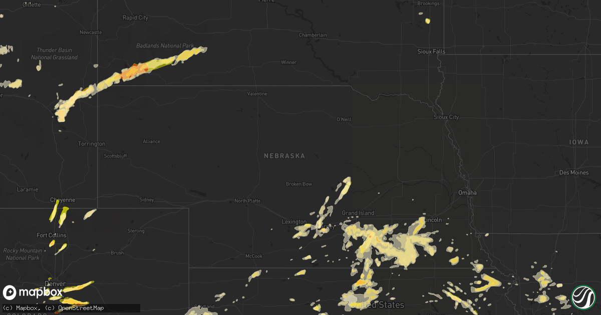
Hail Map in Nebraska on June 3, 2015
Get this storm
June 3 map
$229
one time, instant access
Download today. No call, no setup
Keep the $229
Bought the map and want the full workflow? Apply the entire $229 to a subscription within 7 days. None of it is wasted.
Every map, not just this one
This buys you this map. Subscription and you get every map we run, in the markets you choose from a few cities to whole states to nationwide. Plus real-time alerts the moment a storm fires.
Contact data
Name, contact info, occupancy, even credit band for addresses in the footprint. You go from where it hit to who to call.
Become the source they trust
Unlimited branding weather history reports on demand. You already have the documented answer ready for the property owner, and you are the one who showed up with it.
Property data and RoofTrace estimates
Pull up any address you have got, its value and the exact code rules for that jurisdiction, straight from One Click Code. Then RoofTrace estimates the squares, pitch, and roof value, priced the way you price.
Storm reports in Nebraska
Nebraska
| Date | Description |
|---|---|
| 06/03/20155:52 AM CDT | Gusts estimated greater than 60 mph. Tree branches were blown down. |
| 06/03/20155:29 AM CDT | County dispatch reports nickel to quarter size hail |
| 06/03/20154:39 AM CDT | Quarter size hail and also estimated gusts to 60 mph |
| 06/03/20153:41 AM CDT | A few stones up to quarter size...along showboat road on east side of town |
| 06/03/20152:45 AM CDT | Quarter to half dollar size hail...relayed by broadcast media. |
| 06/03/20151:42 AM CDT | A local report indicates 1.00 inch wind near 3 S KEARNEY |
| 06/03/20151:00 AM CDT | Dime to quarter size at dove hill avenue and highway 30. Facebook report. |
| 06/02/201511:36 PM CDT | Law enforcement reported heavy hail with approximately 30 percent the size of golf balls near church street. |
| 06/02/201511:35 PM CDT | A local report indicates 1.00 inch wind near CLAY CENTER |
| 06/02/201511:27 PM CDT | A local report indicates 1.00 inch wind near FAIRFIELD |
All States Impacted by Hail Map on June 3, 2015
Cities Impacted by Hail Map on June 3, 2015
- Lumber City, GA
- Uvalda, GA
- Hazlehurst, GA
- Hiawatha, KS
- Troy, KS
- Everest, KS
- Robinson, KS
- Denton, KS
- Aurora, CO
- Watkins, CO
- Bennett, CO
- Byers, CO
- Strasburg, CO
- Downs, KS
- Osborne, KS
- Dry Branch, GA
- Macon, GA
- Scotia, NE
- Wolbach, NE
- Rockville, NE
- Greeley, NE
- Ashton, NE
- Farwell, NE
- Boelus, NE
- Elba, NE
- Lexington, GA
- Carlton, GA
- Midwest, WY
- Waldo, KS
- Luray, KS
- West Union, SC
- Walhalla, SC
- Pawnee City, NE
- Steinauer, NE
- Burchard, NE
- Hamilton, MO
- Jeffrey City, WY
- Hortense, GA
- Screven, GA
- Jesup, GA
- Lusk, WY
- Manville, WY
- Lawrence, NE
- Tifton, GA
- Jetmore, KS
- Ness City, KS
- Larned, KS
- Spearville, KS
- Burdett, KS
- Hanston, KS
- Nelson, NE
- Hardy, NE
- Ruskin, NE
- Superior, NE
- Mankato, KS
- Edgar, NE
- Sundance, WY
- Decker, MT
- Lodge Grass, MT
- Milford, NE
- Bristol, GA
- Odum, GA
- McCormick, SC
- Clarkesville, GA
- Sautee Nacoochee, GA
- Oelrichs, SD
- Hot Springs, SD
- Smithwick, SD
- Edgemont, SD
- Glenrock, WY
- Tellico Plains, TN
- Seneca, SC
- Salem, SC
- Augusta, GA
- Grovetown, GA
- Kaycee, WY
- Edson, KS
- Goodland, KS
- Barnesville, GA
- Grand Island, NE
- Gillette, WY
- Riverdale, NE
- Pleasanton, NE
- Burlington, CO
- Weskan, KS
- Kanorado, KS
- Plattsburg, MO
- Glen Elder, KS
- Tipton, KS
- Kiowa, CO
- Elizabeth, CO
- Franktown, CO
- Castle Rock, CO
- Parker, CO
- Long Island, KS
- Prairie View, KS
- Almena, KS
- Oberlin, KS
- Canon, GA
- Royston, GA
- Bowersville, GA
- Grafton, NE
- Sutton, NE
- Fairmont, NE
- Lincoln, NE
- Crete, NE
- Denton, NE
- Dorchester, NE
- Pleasant Dale, NE
- Morrison, CO
- Littleton, CO
- De Witt, NE
- Clatonia, NE
- Wilber, NE
- Western, NE
- Cortland, NE
- Plainville, KS
- Stockton, KS
- Jamestown, KS
- Jewell, KS
- Onaga, KS
- Wellington, CO
- Casper, WY
- Kearney, NE
- Axtell, NE
- Montrose, GA
- Danville, GA
- Havensville, KS
- Westmoreland, KS
- Frankfort, KS
- Moreland, GA
- Newnan, GA
- Plum Branch, SC
- Stephens, GA
- Palmetto, GA
- Clay Center, NE
- Bertrand, NE
- Porcupine, SD
- Wanblee, SD
- Kyle, SD
- Arlington, GA
- Hiawassee, GA
- Hayesville, NC
- Vermillion, KS
- Evergreen, CO
- Golden, CO
- Trenton, UT
- Clarkston, UT
- Cornish, UT
- Plymouth, UT
- Hallam, NE
- Glendo, WY
- Powhattan, KS
- Fairview, KS
- Larkspur, CO
- Colman, SD
- Flandreau, SD
- Jeffersonville, GA
- Fairbury, NE
- Daykin, NE
- Alexandria, NE
- Carleton, NE
- Jansen, NE
- Hebron, NE
- Belvidere, NE
- Hubbell, NE
- Davenport, NE
- Gilead, NE
- Reynolds, NE
- Bruning, NE
- Tobias, NE
- Plymouth, NE
- Esbon, KS
- Burr Oak, KS
- Valdosta, GA
- Green, KS
- Randolph, KS
- Rebecca, GA
- Westminster, SC
- Cheyenne, WY
- Lathrop, MO
- Greensboro, GA
- Eatonton, GA
- Buckhead, GA
- Keysville, GA
- Karval, CO
- Sugar City, CO
- Minden, NE
- Enigma, GA
- Alapaha, GA
- Grover, CO
- Hastings, NE
- Big Timber, MT
- Corinne, UT
- Snowville, UT
- Kidder, MO
- Cameron, MO
- Harrison, NE
- Roseland, NE
- Bladen, NE
- Loomis, NE
- Holt, MO
- Kearney, MO
- Lawson, MO
- Table Rock, NE
- Doniphan, NE
- Arapahoe, CO
- Sharon Springs, KS
- Lexington, NE
- Smithfield, NE
- Elwood, NE
- Overton, NE
- Elm Creek, NE
- Holton, KS
- Townville, SC
- Anderson, SC
- Odessa, NE
- Wood River, NE
- Dubois, WY
- Centralia, KS
- Moorcroft, WY
- Bogue, KS
- Hill City, KS
- Hugo, CO
- Shickley, NE
- Inland, NE
- Saronville, NE
- Milligan, NE
- Ong, NE
- Deweese, NE
- Harvard, NE
- Fairfield, NE
- Jackson, GA
- Portis, KS
- Carr, CO
- Nunn, CO
- Horton, KS
- Winston, MO
- Maysville, MO
- Weatherby, MO
- Osborn, MO
- Smithville, GA
- Turney, MO
- Trimble, MO
- Hephzibah, GA
- Blythe, GA
- Register, GA
- Statesboro, GA
- Amherst, NE
- Ault, CO
- Randall, KS
- Arvada, CO
- Wheat Ridge, CO
- Mayetta, KS
- Hoyt, KS
- Delia, KS
- Beatrice, NE
- Lenox, GA
- Six Mile, SC
- Central, SC
- Louviers, CO
- Sedalia, CO
- Lone Tree, CO
- Camden, MO
- Richmond, MO
- Beloit, KS
- Americus, GA
- Plains, GA
- Matthews, GA
- Wrens, GA
- Nashville, GA
- Munden, KS
- Olney Springs, CO
- Shawnee, WY
- Lance Creek, WY
- Aurora, KS
- Braymer, MO
- Norborne, MO
- Cowgill, MO
- Polo, MO
- Buffalo, WY
- Locust Grove, GA
- Milner, GA
- Jenkinsburg, GA
- Cleveland, GA
- Netawaka, KS
- Whiting, KS
- Oxford, NE
- Northboro, IA
- Riverton, NE
- Olsburg, KS
- Hodges, SC
- Guide Rock, NE
- Grantsville, UT
- White Cloud, KS
- Murphy, NC
- Colby, KS
- Loveland, CO
- Cawker City, KS
- Providence, UT
- Logan, UT
- Alma, NE
- Orleans, NE
- Agate, CO
- Iva, SC
- Calhoun Falls, SC
- Abbeville, SC
- Falls City, NE
- Morrill, KS
- Salem, NE
- Milliken, CO
- Greeley, CO
- Saint Joseph, MO
- Tremonton, UT
- Ordway, CO
- Forsyth, GA
- Sterling, NE
- Evans, CO
- Platteville, CO
- Johnstown, CO
- Mead, CO
- Lakeland, GA
- Pine Ridge, SD
- Franklin, NC
- Edgerton, MO
- Juniata, NE
- Blue Hill, NE
- Glenvil, NE
- Strang, NE
- Trumbull, NE
- Kenesaw, NE
- Ohiowa, NE
- Lost Springs, WY
- Geneva, NE
- Swanton, NE
- McCool Junction, NE
- Friend, NE
- Ayr, NE
- Henderson, NE
- Douglas, WY
- Oral, SD
- Stewartsville, MO
- Amity, MO
- Pavillion, WY
- Bendena, KS
- Atchison, KS
- Chula, GA
- Savannah, GA
- Richmond Hill, GA
- Wilcox, NE
- Dublin, GA
- Palmyra, NE
- Busby, MT
- Whitesburg, GA
- Swainsboro, GA
- Clarks, NE
- Levant, KS
- Timnath, CO
- Fort Collins, CO
- Waynesville, GA
- Waverly, GA
- White Oak, GA
- Rabun Gap, GA
- Otto, NC
- Boone, CO
- Fowler, CO
- Sabetha, KS
- Deshler, NE
- Soldier, KS
- Goff, KS
- Edgefield, SC
- Modoc, SC
- Clarks Hill, SC
- Troy, SC
- Bradley, SC
- Ninety Six, SC
- Litchfield, NE
- Formoso, KS
- Webber, KS
- Bloomington, NE
- Mauk, GA
- Rupert, GA
- Hardin, MO
- Holstein, NE
- Lincolnton, GA
- Worland, WY
- Thermopolis, WY
- Preston, ID
- Natoma, KS
- Starr, SC
- East Dublin, GA
- Wyola, MT
- Leonardville, KS
- Coolidge, GA
- Lucas, KS
- Seneca, KS
- Manderson, SD
- Sheridan, WY
- Clayton, GA
- Pattonsburg, MO
- Copperhill, TN
- Brooklet, GA
- Schuyler, NE
- Thomaston, GA
- Knoxville, GA
- Fort Valley, GA
- Lizella, GA
- Adrian, GA
- Helen, GA
- Breckenridge, MO
- Buena Vista, GA
- Crowheart, WY
- Bonaire, GA
- Belleville, KS
- Concordia, KS
- Funk, NE
- Hazard, NE
- Ravenna, NE
- Holdrege, NE
- Loup City, NE
- Reed Point, MT
- Surrency, GA
- Statenville, GA
- Fargo, GA
- Two Dot, MT
- Red Cloud, NE
- Chester, NE
- Filley, NE
- Exeter, NE
- Giltner, NE
- Oak, NE
- Aurora, NE
- Endicott, NE
- Pickrell, NE
- Clarinda, IA
- Lewiston, UT
- Shelton, NE
- Adams, NE
- Senoia, GA
- Sharpsburg, GA
- Rayville, MO
- King City, MO
- Omega, GA
- Alcova, WY
- Bozeman, MT
- Phillipsburg, KS
- Humboldt, NE
- Dawson, NE
- Gibbon, NE
- Excelsior Springs, MO
- Hanna, WY
- Blue Ridge, GA
- Epworth, GA
- Conifer, CO
- Buffalo Creek, CO
- Fort Stewart, GA
- Dover, MO
- Waverly, MO
- Folkston, GA
- Nahunta, GA
- Greenwood, SC
- Wetmore, KS
- Kinsley, KS
- Corning, KS
- Du Pont, GA
- Malcolm, NE
- Ellaville, GA
- Damascus, GA
- Colquitt, GA
- Lake Park, GA
- Demorest, GA
- Tecumseh, NE
- Crab Orchard, NE
- Hartville, WY
- Farnam, NE
- Leesburg, GA
- Courtland, KS
- Seward, NE
- Norway, KS
- Scandia, KS
- Hickman, NE
- Firth, NE
- Martell, NE
- Mahaska, KS
- Elmwood, NE
- New London, MN
- Westboro, MO
- Rock Port, MO
- Odessa, MO
- Luthersville, GA
- Elk Creek, NE
- Republican City, NE
- Stockton, GA
- Naylor, GA
- Beaver City, NE
- Tyrone, GA
- McRae Helena, GA
- Lavonia, GA
- Jennings, FL
- Pansey, AL
- Cordele, GA
- Garryowen, MT
- Gordon, GA
- Irwinton, GA
- Ocilla, GA
- Bethany, MO
- Wiggins, CO
- Bethune, CO
- Verdon, NE
- Reliance, TN
- Narka, KS
- Elberton, GA
- Ten Sleep, WY
- Princeton, KS
- Talmage, NE
- Nebraska City, NE
- Sauk Rapids, MN
- Sweetwater, TN
- Ely, NV
- Montevideo, MN
- Topeka, KS
- Emmett, KS
- Wamego, KS
- Ashburn, GA
- Beaver Crossing, NE
- Donalds, SC
- Coin, IA
- Douglasville, GA
- Atwood, KS
- Denver, CO
- Meigs, GA
- Sale City, GA
- Hartsfield, GA
- Guernsey, WY
- Wellington, MO
- David City, NE
- Alda, NE
- Wathena, KS
- Amazonia, MO
- Berthoud, CO
- Norton, KS
- Blue Rapids, KS
- Waterville, KS
- Cornelia, GA
- Union Point, GA
- Pine, CO
- Orrick, MO
- Marble, NC
- Franklin, NE
- Harrison, MT
- Moultrie, GA
- Nunda, SD
- Rutland, SD
- Ludowici, GA
- Kit Carson, CO
- Cochran, GA
- Gower, MO
- Easton, MO
- Clarksdale, MO
- Cosby, MO
- Valley Falls, KS
- Miller, NE
- Englewood, CO
- Ramah, CO
- Shoshoni, WY


