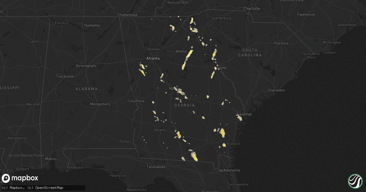
Hail Map in Georgia on June 3, 2015
Get this storm
June 3 map
$229
one time, instant access
Download today. No call, no setup
Keep the $229
Bought the map and want the full workflow? Apply the entire $229 to a subscription within 7 days. None of it is wasted.
Every map, not just this one
This buys you this map. Subscription and you get every map we run, in the markets you choose from a few cities to whole states to nationwide. Plus real-time alerts the moment a storm fires.
Contact data
Name, contact info, occupancy, even credit band for addresses in the footprint. You go from where it hit to who to call.
Become the source they trust
Unlimited branding weather history reports on demand. You already have the documented answer ready for the property owner, and you are the one who showed up with it.
Property data and RoofTrace estimates
Pull up any address you have got, its value and the exact code rules for that jurisdiction, straight from One Click Code. Then RoofTrace estimates the squares, pitch, and roof value, priced the way you price.
Storm reports in Georgia
Georgia
| Date | Description |
|---|---|
| 06/03/20156:55 PM CDT | Camden county 911 dispatch reports a tree downed by strong wind gusts across new post road just north of tarboro. |
| 06/03/20156:42 PM CDT | Large tree down on highway 129. |
| 06/03/20156:39 PM CDT | Tree down near the intersection of mt pleasant road and lancaster road |
| 06/03/20156:35 PM CDT | Tree down on cook road |
| 06/03/20156:15 PM CDT | Tree down near the intersection of radio station road and mark watson road |
| 06/03/20156:15 PM CDT | Tree down on highway 76 |
| 06/03/20156:15 PM CDT | Tree down on rogers ave in nashville |
| 06/03/20155:52 PM CDT | Trees down in the sandy cross region. Also had reports of small hail covering the ground making it look as if it snowed. |
| 06/03/20155:32 PM CDT | Numerous trees down. Reports of at least 6 to 8 with reports still coming in to ema. |
| 06/03/20155:10 PM CDT | Social media picture of hail estimated at around hen egg size or 2 inches in diameter from brookfield |
| 06/03/20155:10 PM CDT | Quarter sized hail reported east of tifton |
| 06/03/20155:07 PM CDT | Trees down in the vanceville area |
| 06/03/20155:07 PM CDT | Roof and siding damage due to large hail in the vanceville area |
| 06/03/20155:01 PM CDT | Large and small tree limbs down in various places around jesup |
| 06/03/20155:00 PM CDT | Trees snapped or uprooted and large trees down on power line near country club |
| 06/03/20154:55 PM CDT | A couple of trees down around paulk road and highway 319 |
| 06/03/20154:30 PM CDT | Dime to quarter sized hail fell for about 15 minutes at this location on majestic way near clarkesville. Strong wind but no damage was obvious at the time of the call. |
| 06/03/20154:30 PM CDT | Golf ball sized hail reported near the white county border. |
| 06/03/20154:26 PM CDT | Dime to up to quarter sized hail fell briefly in sautee. Report from a hotel clerk in sautee |
| 06/03/20154:25 PM CDT | Trees and powerlines reported down in the jesup city limits. Update...dispatch reported around 40 trees downed near wayne county country club in the jesup city limits a |
| 06/03/20154:09 PM CDT | Lots of trees down. Several on i-20 at mile marker 125. Traffic still backed up as of 6pm. |
| 06/03/20154:02 PM CDT | Web report of quarter sized hail |
| 06/03/20153:56 PM CDT | Dime to golf ball sized hail falling at i85 exit in newnan. Time estimated from radar |
| 06/03/20153:54 PM CDT | A local report indicates 1.00 inch wind near NEWNAN |
| 06/03/20153:38 PM CDT | Several trees blown down in the area off tommy lee cook road and cainbridge park drive |
| 06/03/20153:25 PM CDT | A local report indicates 1.00 inch wind near 2 W PALMETTO |
| 06/03/20152:26 PM CDT | Public reported quarter size hail and gusty winds along cypress lake rd. |
| 06/03/20152:21 PM CDT | Spotter reported quarter size hail and 4 inch branches down along langston chapel rd. |
| 06/03/20151:55 PM CDT | Dime to quarter size hail fell between 255pm and 310pm. Reported by public and twiggs 911 |
| 06/03/20151:55 PM CDT | Numerous trees down blocking roads near jeffersonville. Very near kjgx radar as well as durham mill rd and us 80. |
| 06/03/20151:41 PM CDT | Trees down on salt creek rd near highway 17. |
| 06/03/20151:10 PM CDT | Numerous trees and power lines down near uvalda hwy |
| 06/02/20158:00 PM CDT | Numerous large trees down across the area. |
| 06/02/20157:45 PM CDT | Numerous trees down across the area. |
All States Impacted by Hail Map on June 3, 2015
Cities Impacted by Hail Map on June 3, 2015
- Lumber City, GA
- Uvalda, GA
- Hazlehurst, GA
- Hiawatha, KS
- Troy, KS
- Everest, KS
- Robinson, KS
- Denton, KS
- Aurora, CO
- Watkins, CO
- Bennett, CO
- Byers, CO
- Strasburg, CO
- Downs, KS
- Osborne, KS
- Dry Branch, GA
- Macon, GA
- Scotia, NE
- Wolbach, NE
- Rockville, NE
- Greeley, NE
- Ashton, NE
- Farwell, NE
- Boelus, NE
- Elba, NE
- Lexington, GA
- Carlton, GA
- Midwest, WY
- Waldo, KS
- Luray, KS
- West Union, SC
- Walhalla, SC
- Pawnee City, NE
- Steinauer, NE
- Burchard, NE
- Hamilton, MO
- Jeffrey City, WY
- Hortense, GA
- Screven, GA
- Jesup, GA
- Lusk, WY
- Manville, WY
- Lawrence, NE
- Tifton, GA
- Jetmore, KS
- Ness City, KS
- Larned, KS
- Spearville, KS
- Burdett, KS
- Hanston, KS
- Nelson, NE
- Hardy, NE
- Ruskin, NE
- Superior, NE
- Mankato, KS
- Edgar, NE
- Sundance, WY
- Decker, MT
- Lodge Grass, MT
- Milford, NE
- Bristol, GA
- Odum, GA
- McCormick, SC
- Clarkesville, GA
- Sautee Nacoochee, GA
- Oelrichs, SD
- Hot Springs, SD
- Smithwick, SD
- Edgemont, SD
- Glenrock, WY
- Tellico Plains, TN
- Seneca, SC
- Salem, SC
- Augusta, GA
- Grovetown, GA
- Kaycee, WY
- Edson, KS
- Goodland, KS
- Barnesville, GA
- Grand Island, NE
- Gillette, WY
- Riverdale, NE
- Pleasanton, NE
- Burlington, CO
- Weskan, KS
- Kanorado, KS
- Plattsburg, MO
- Glen Elder, KS
- Tipton, KS
- Kiowa, CO
- Elizabeth, CO
- Franktown, CO
- Castle Rock, CO
- Parker, CO
- Long Island, KS
- Prairie View, KS
- Almena, KS
- Oberlin, KS
- Canon, GA
- Royston, GA
- Bowersville, GA
- Grafton, NE
- Sutton, NE
- Fairmont, NE
- Lincoln, NE
- Crete, NE
- Denton, NE
- Dorchester, NE
- Pleasant Dale, NE
- Morrison, CO
- Littleton, CO
- De Witt, NE
- Clatonia, NE
- Wilber, NE
- Western, NE
- Cortland, NE
- Plainville, KS
- Stockton, KS
- Jamestown, KS
- Jewell, KS
- Onaga, KS
- Wellington, CO
- Casper, WY
- Kearney, NE
- Axtell, NE
- Montrose, GA
- Danville, GA
- Havensville, KS
- Westmoreland, KS
- Frankfort, KS
- Moreland, GA
- Newnan, GA
- Plum Branch, SC
- Stephens, GA
- Palmetto, GA
- Clay Center, NE
- Bertrand, NE
- Porcupine, SD
- Wanblee, SD
- Kyle, SD
- Arlington, GA
- Hiawassee, GA
- Hayesville, NC
- Vermillion, KS
- Evergreen, CO
- Golden, CO
- Trenton, UT
- Clarkston, UT
- Cornish, UT
- Plymouth, UT
- Hallam, NE
- Glendo, WY
- Powhattan, KS
- Fairview, KS
- Larkspur, CO
- Colman, SD
- Flandreau, SD
- Jeffersonville, GA
- Fairbury, NE
- Daykin, NE
- Alexandria, NE
- Carleton, NE
- Jansen, NE
- Hebron, NE
- Belvidere, NE
- Hubbell, NE
- Davenport, NE
- Gilead, NE
- Reynolds, NE
- Bruning, NE
- Tobias, NE
- Plymouth, NE
- Esbon, KS
- Burr Oak, KS
- Valdosta, GA
- Green, KS
- Randolph, KS
- Rebecca, GA
- Westminster, SC
- Cheyenne, WY
- Lathrop, MO
- Greensboro, GA
- Eatonton, GA
- Buckhead, GA
- Keysville, GA
- Karval, CO
- Sugar City, CO
- Minden, NE
- Enigma, GA
- Alapaha, GA
- Grover, CO
- Hastings, NE
- Big Timber, MT
- Corinne, UT
- Snowville, UT
- Kidder, MO
- Cameron, MO
- Harrison, NE
- Roseland, NE
- Bladen, NE
- Loomis, NE
- Holt, MO
- Kearney, MO
- Lawson, MO
- Table Rock, NE
- Doniphan, NE
- Arapahoe, CO
- Sharon Springs, KS
- Lexington, NE
- Smithfield, NE
- Elwood, NE
- Overton, NE
- Elm Creek, NE
- Holton, KS
- Townville, SC
- Anderson, SC
- Odessa, NE
- Wood River, NE
- Dubois, WY
- Centralia, KS
- Moorcroft, WY
- Bogue, KS
- Hill City, KS
- Hugo, CO
- Shickley, NE
- Inland, NE
- Saronville, NE
- Milligan, NE
- Ong, NE
- Deweese, NE
- Harvard, NE
- Fairfield, NE
- Jackson, GA
- Portis, KS
- Carr, CO
- Nunn, CO
- Horton, KS
- Winston, MO
- Maysville, MO
- Weatherby, MO
- Osborn, MO
- Smithville, GA
- Turney, MO
- Trimble, MO
- Hephzibah, GA
- Blythe, GA
- Register, GA
- Statesboro, GA
- Amherst, NE
- Ault, CO
- Randall, KS
- Arvada, CO
- Wheat Ridge, CO
- Mayetta, KS
- Hoyt, KS
- Delia, KS
- Beatrice, NE
- Lenox, GA
- Six Mile, SC
- Central, SC
- Louviers, CO
- Sedalia, CO
- Lone Tree, CO
- Camden, MO
- Richmond, MO
- Beloit, KS
- Americus, GA
- Plains, GA
- Matthews, GA
- Wrens, GA
- Nashville, GA
- Munden, KS
- Olney Springs, CO
- Shawnee, WY
- Lance Creek, WY
- Aurora, KS
- Braymer, MO
- Norborne, MO
- Cowgill, MO
- Polo, MO
- Buffalo, WY
- Locust Grove, GA
- Milner, GA
- Jenkinsburg, GA
- Cleveland, GA
- Netawaka, KS
- Whiting, KS
- Oxford, NE
- Northboro, IA
- Riverton, NE
- Olsburg, KS
- Hodges, SC
- Guide Rock, NE
- Grantsville, UT
- White Cloud, KS
- Murphy, NC
- Colby, KS
- Loveland, CO
- Cawker City, KS
- Providence, UT
- Logan, UT
- Alma, NE
- Orleans, NE
- Agate, CO
- Iva, SC
- Calhoun Falls, SC
- Abbeville, SC
- Falls City, NE
- Morrill, KS
- Salem, NE
- Milliken, CO
- Greeley, CO
- Saint Joseph, MO
- Tremonton, UT
- Ordway, CO
- Forsyth, GA
- Sterling, NE
- Evans, CO
- Platteville, CO
- Johnstown, CO
- Mead, CO
- Lakeland, GA
- Pine Ridge, SD
- Franklin, NC
- Edgerton, MO
- Juniata, NE
- Blue Hill, NE
- Glenvil, NE
- Strang, NE
- Trumbull, NE
- Kenesaw, NE
- Ohiowa, NE
- Lost Springs, WY
- Geneva, NE
- Swanton, NE
- McCool Junction, NE
- Friend, NE
- Ayr, NE
- Henderson, NE
- Douglas, WY
- Oral, SD
- Stewartsville, MO
- Amity, MO
- Pavillion, WY
- Bendena, KS
- Atchison, KS
- Chula, GA
- Savannah, GA
- Richmond Hill, GA
- Wilcox, NE
- Dublin, GA
- Palmyra, NE
- Busby, MT
- Whitesburg, GA
- Swainsboro, GA
- Clarks, NE
- Levant, KS
- Timnath, CO
- Fort Collins, CO
- Waynesville, GA
- Waverly, GA
- White Oak, GA
- Rabun Gap, GA
- Otto, NC
- Boone, CO
- Fowler, CO
- Sabetha, KS
- Deshler, NE
- Soldier, KS
- Goff, KS
- Edgefield, SC
- Modoc, SC
- Clarks Hill, SC
- Troy, SC
- Bradley, SC
- Ninety Six, SC
- Litchfield, NE
- Formoso, KS
- Webber, KS
- Bloomington, NE
- Mauk, GA
- Rupert, GA
- Hardin, MO
- Holstein, NE
- Lincolnton, GA
- Worland, WY
- Thermopolis, WY
- Preston, ID
- Natoma, KS
- Starr, SC
- East Dublin, GA
- Wyola, MT
- Leonardville, KS
- Coolidge, GA
- Lucas, KS
- Seneca, KS
- Manderson, SD
- Sheridan, WY
- Clayton, GA
- Pattonsburg, MO
- Copperhill, TN
- Brooklet, GA
- Schuyler, NE
- Thomaston, GA
- Knoxville, GA
- Fort Valley, GA
- Lizella, GA
- Adrian, GA
- Helen, GA
- Breckenridge, MO
- Buena Vista, GA
- Crowheart, WY
- Bonaire, GA
- Belleville, KS
- Concordia, KS
- Funk, NE
- Hazard, NE
- Ravenna, NE
- Holdrege, NE
- Loup City, NE
- Reed Point, MT
- Surrency, GA
- Statenville, GA
- Fargo, GA
- Two Dot, MT
- Red Cloud, NE
- Chester, NE
- Filley, NE
- Exeter, NE
- Giltner, NE
- Oak, NE
- Aurora, NE
- Endicott, NE
- Pickrell, NE
- Clarinda, IA
- Lewiston, UT
- Shelton, NE
- Adams, NE
- Senoia, GA
- Sharpsburg, GA
- Rayville, MO
- King City, MO
- Omega, GA
- Alcova, WY
- Bozeman, MT
- Phillipsburg, KS
- Humboldt, NE
- Dawson, NE
- Gibbon, NE
- Excelsior Springs, MO
- Hanna, WY
- Blue Ridge, GA
- Epworth, GA
- Conifer, CO
- Buffalo Creek, CO
- Fort Stewart, GA
- Dover, MO
- Waverly, MO
- Folkston, GA
- Nahunta, GA
- Greenwood, SC
- Wetmore, KS
- Kinsley, KS
- Corning, KS
- Du Pont, GA
- Malcolm, NE
- Ellaville, GA
- Damascus, GA
- Colquitt, GA
- Lake Park, GA
- Demorest, GA
- Tecumseh, NE
- Crab Orchard, NE
- Hartville, WY
- Farnam, NE
- Leesburg, GA
- Courtland, KS
- Seward, NE
- Norway, KS
- Scandia, KS
- Hickman, NE
- Firth, NE
- Martell, NE
- Mahaska, KS
- Elmwood, NE
- New London, MN
- Westboro, MO
- Rock Port, MO
- Odessa, MO
- Luthersville, GA
- Elk Creek, NE
- Republican City, NE
- Stockton, GA
- Naylor, GA
- Beaver City, NE
- Tyrone, GA
- McRae Helena, GA
- Lavonia, GA
- Jennings, FL
- Pansey, AL
- Cordele, GA
- Garryowen, MT
- Gordon, GA
- Irwinton, GA
- Ocilla, GA
- Bethany, MO
- Wiggins, CO
- Bethune, CO
- Verdon, NE
- Reliance, TN
- Narka, KS
- Elberton, GA
- Ten Sleep, WY
- Princeton, KS
- Talmage, NE
- Nebraska City, NE
- Sauk Rapids, MN
- Sweetwater, TN
- Ely, NV
- Montevideo, MN
- Topeka, KS
- Emmett, KS
- Wamego, KS
- Ashburn, GA
- Beaver Crossing, NE
- Donalds, SC
- Coin, IA
- Douglasville, GA
- Atwood, KS
- Denver, CO
- Meigs, GA
- Sale City, GA
- Hartsfield, GA
- Guernsey, WY
- Wellington, MO
- David City, NE
- Alda, NE
- Wathena, KS
- Amazonia, MO
- Berthoud, CO
- Norton, KS
- Blue Rapids, KS
- Waterville, KS
- Cornelia, GA
- Union Point, GA
- Pine, CO
- Orrick, MO
- Marble, NC
- Franklin, NE
- Harrison, MT
- Moultrie, GA
- Nunda, SD
- Rutland, SD
- Ludowici, GA
- Kit Carson, CO
- Cochran, GA
- Gower, MO
- Easton, MO
- Clarksdale, MO
- Cosby, MO
- Valley Falls, KS
- Miller, NE
- Englewood, CO
- Ramah, CO
- Shoshoni, WY


