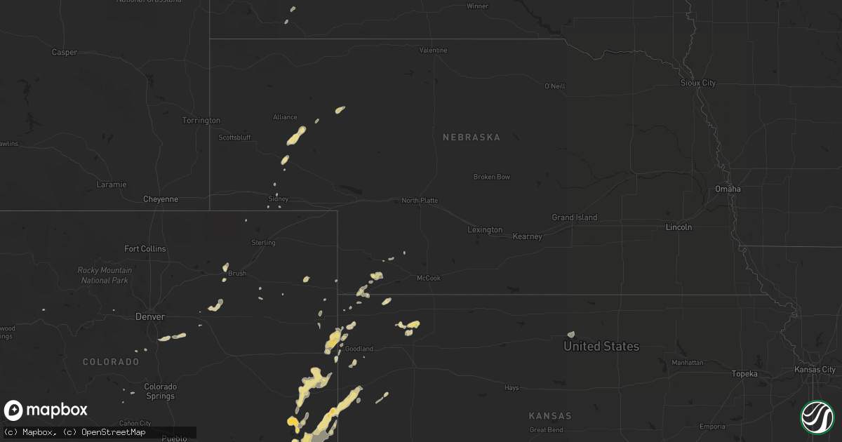
Hail Map in Colorado on June 2, 2012
Get this storm
June 2 map
$229
one time, instant access
Download today. No call, no setup
Keep the $229
Bought the map and want the full workflow? Apply the entire $229 to a subscription within 7 days. None of it is wasted.
Every map, not just this one
This buys you this map. Subscription and you get every map we run, in the markets you choose from a few cities to whole states to nationwide. Plus real-time alerts the moment a storm fires.
Contact data
Name, contact info, occupancy, even credit band for addresses in the footprint. You go from where it hit to who to call.
Become the source they trust
Unlimited branding weather history reports on demand. You already have the documented answer ready for the property owner, and you are the one who showed up with it.
Property data and RoofTrace estimates
Pull up any address you have got, its value and the exact code rules for that jurisdiction, straight from One Click Code. Then RoofTrace estimates the squares, pitch, and roof value, priced the way you price.
Storm reports in Colorado
Colorado
| Date | Description |
|---|---|
| 06/02/20126:38 PM CDT | Power pole snapped hwy 96 mile marker 182 |
| 06/02/20126:28 PM CDT | A local report indicates a tornado near 4 SW FIRSTVIEW |
| 06/02/20126:12 PM CDT | Zero visibility due to blowing dust in thunderstorm outflow winds |
| 06/02/20126:10 PM CDT | A local report indicates 1.25 inch wind near 4 E SHERIDAN LAKE |
| 06/02/20126:10 PM CDT | A local report indicates 1.50 inch wind near 10 NE SHERIDAN LAKE |
| 06/02/20126:08 PM CDT | Relayed by em from deputies in field |
| 06/02/20126:05 PM CDT | A local report indicates 1.75 inch wind near 3 SE EADS |
| 06/02/20126:05 PM CDT | A local report indicates 1.00 inch wind near EADS |
| 06/02/20126:00 PM CDT | A local report indicates 66 MPH wind near 4 W LAMAR |
| 06/02/20125:55 PM CDT | Collapsed awning at phillips 66 at main and lee streets |
| 06/02/20125:52 PM CDT | Correction for spotter location. |
| 06/02/20125:52 PM CDT | A local report indicates 1.00 inch wind near SHERIDAN LAKE |
| 06/02/20125:50 PM CDT | A local report indicates 58 MPH wind near STERLING |
| 06/02/20125:48 PM CDT | A 60 foot tall 24 inch diameter pine tree toppled. Tree estimated at 80 years old. A large 12 inch diameter tree branch was blown into home. Large cottonwood tree blown |
| 06/02/20125:30 PM CDT | A local report indicates 1.50 inch wind near WILEY |
| 06/02/20125:22 PM CDT | A local report indicates 1.00 inch wind near BRISTOL |
| 06/02/20125:15 PM CDT | A local report indicates 60 MPH wind near 4 N ADENA |
| 06/02/20125:04 PM CDT | A local report indicates 65 MPH wind near 2 W BRUSH |
| 06/02/20125:00 PM CDT | A local report indicates 59 MPH wind near LAST CHANCE |
| 06/02/20124:57 PM CDT | 5 inch diameter tree snapped. Numerous branches of 3-5 inches snapped. |
| 06/02/20124:53 PM CDT | Tree branches of 5 inch diameter snapped |
| 06/02/20124:52 PM CDT | A local report indicates 59 MPH wind near WOODROW |
| 06/02/20124:40 PM CDT | A local report indicates 1.00 inch wind near 7 NW LAST CHANCE |
| 06/02/20124:40 PM CDT | A local report indicates 60 MPH wind near 1 S CEDAR POINT |
| 06/02/20124:18 PM CDT | A local report indicates 60 MPH wind near 12 NE DEER TRAIL |
| 06/02/20124:15 PM CDT | Considerable roof damage to home. |
| 06/02/20124:02 PM CDT | A local report indicates 82 MPH wind near 1 N STRASBURG |
| 06/02/20123:51 PM CDT | Front range airport |
| 06/02/20123:43 PM CDT | A local report indicates 67 MPH wind near DENVER INTL AIRPORT |
| 06/02/20123:35 PM CDT | A local report indicates 61 MPH wind near BUCKLEY AFB |
| 06/02/20123:33 PM CDT | A local report indicates 1.00 inch wind near 9 SW KIM |
| 06/02/20123:29 PM CDT | Tree branches 2-4 inch diameter snapped |
| 06/02/20123:27 PM CDT | A local report indicates 1.00 inch wind near 3 E PARKER |
| 06/02/20122:38 PM CDT | Mesonet site c5171 |
| 06/01/20127:10 PM CDT | 8 power poles blown down near co rd 39 and kk. |
All States Impacted by Hail Map on June 2, 2012
Cities Impacted by Hail Map on June 2, 2012
- Brusett, MT
- Perryton, TX
- Cheney, KS
- Garden Plain, KS
- Colcord, OK
- Decatur, AR
- Jay, OK
- Gentry, AR
- Maysville, AR
- Gravette, AR
- Laverne, OK
- Gate, OK
- Rosston, OK
- Buffalo, OK
- Kanorado, KS
- Saint Francis, KS
- Burlington, CO
- Idalia, CO
- Roy, MT
- Chester, OK
- Clinton, OK
- Corn, OK
- Foss, OK
- Goodwell, OK
- Texhoma, OK
- Spearman, TX
- Gruver, TX
- Gould, OK
- Eldorado, OK
- Duke, OK
- Big Sandy, MT
- Wichita, KS
- Anadarko, OK
- Freedom, OK
- Chickasha, OK
- Verden, OK
- El Dorado, KS
- Rosalia, KS
- Eads, CO
- Seiling, OK
- Walters, OK
- Lawton, OK
- Cache, OK
- Faxon, OK
- Parsons, KS
- Galesburg, KS
- Erie, KS
- Alva, OK
- Walsh, CO
- Butler, OK
- Sedalia, CO
- Claremore, OK
- Pampa, TX
- Atwood, KS
- Broadwater, NE
- Fowler, CO
- Boone, CO
- Leedey, OK
- Custer City, OK
- Taloga, OK
- Wheeler, TX
- Parks, NE
- Benkelman, NE
- South West City, MO
- Noel, MO
- Anderson, MO
- Lanagan, MO
- Chelsea, OK
- Wiley, CO
- Canyon, TX
- Ringwood, OK
- Lamar, MO
- Wray, CO
- Cheyenne Wells, CO
- Kit Carson, CO
- Bethune, CO
- Anthony, KS
- Canadian, TX
- Effingham, IL
- Teutopolis, IL
- Stilwell, OK
- Bunch, OK
- Aline, OK
- Arapahoe, CO
- Muleshoe, TX
- Las Animas, CO
- Proctor, OK
- Westville, OK
- Richfield, KS
- Rolla, KS
- Hugoton, KS
- Augusta, KS
- Douglass, KS
- Byers, CO
- Sharon Springs, KS
- Tribune, KS
- Weskan, KS
- Sheridan Lake, CO
- Lamar, CO
- Holly, CO
- Waynoka, OK
- Carmen, OK
- Helena, OK
- Dacoma, OK
- Cherokee, OK
- Sayre, OK
- Carter, OK
- Oshkosh, NE
- Bridgeport, NE
- Argonia, KS
- Mangum, OK
- Medicine Lodge, KS
- Stratford, TX
- Isabella, OK
- Fairview, OK
- Cheyenne, OK
- Hammon, OK
- McCune, KS
- Fritch, TX
- Borger, TX
- Stinnett, TX
- Shattuck, OK
- Winona, KS
- Fall River, KS
- Weatherford, OK
- Fort Morgan, CO
- Caldwell, KS
- Tahlequah, OK
- Guthrie, OK
- Erick, OK
- Thomas, OK
- Kansas, OK
- Folsom, NM
- Oologah, OK
- Walsenburg, CO
- McDonald, KS
- Collinsville, OK
- Big Cabin, OK
- Vinita, OK
- Adair, OK
- Sudan, TX
- Kingfisher, OK
- Okarche, OK
- Cordell, OK
- Mountain View, OK
- Clarendon, TX
- Elizabeth, CO
- Parker, CO
- Bennett, CO
- Kiowa, CO
- Pawhuska, OK
- Barnsdall, OK
- Wynona, OK
- Amherst, TX
- Dillon, MT
- Boncarbo, CO
- Trinidad, CO
- Benton, KS
- Goodland, KS
- Dill City, OK
- Sentinel, OK
- Fredonia, KS
- Booker, TX
- Welling, OK
- Hitchcock, OK
- Watonga, OK
- Geraldine, MT
- Harper, KS
- Stewardson, IL
- Sigel, IL
- Shumway, IL
- Dieterich, IL
- Prairie Grove, AR
- Canehill, AR
- Coldwater, KS
- Bartlesville, OK
- Shamrock, TX
- Cripple Creek, CO
- Florissant, CO
- Nara Visa, NM
- Logan, NM
- Eckley, CO
- Yuma, CO
- Delaware, OK
- Nowata, OK
- Willow, OK
- Coffee Creek, MT
- Central City, CO
- Minco, OK
- Geary, OK
- Arapaho, OK
- Siloam Springs, AR
- Snyder, OK
- Circle, MT
- Salina, OK
- Miami, TX
- Castle Rock, CO
- Melrose, NM
- Mcalister, NM
- House, NM
- Severy, KS
- Presho, SD
- Kim, CO
- Clayton, NM
- Colby, KS
- Talala, OK
- Guymon, OK
- Pine Ridge, SD
- Longton, KS
- Stanford, MT
- Calumet, OK
- Sunray, TX
- Arnett, OK
- Benedict, KS
- Ashby, NE
- Ellsworth, NE
- Dardanelle, AR
- Akron, CO
- Colony, OK
- Sharon, OK
- Woodward, OK
- Chanute, KS
- Carnegie, OK
- Lewistown, MT
- Grenola, KS
- Watts, OK
- Bond, CO
- Roosevelt, UT
- Sidney, NE
- Kingman, KS
- Murdock, KS
- Fort Supply, OK
- Palisade, NE
- Mcconnell Afb, KS
- Derby, KS
- Okeene, OK
- Rose Hill, KS
- Enid, OK
- Taiban, NM
- Cherokee, KS
- Hasty, CO
- Greenwich, KS
- Kechi, KS
- Valley Center, KS
- Mclean, TX
- Goddard, KS
- Hereford, TX
- Andale, KS
- Weston, CO
- Cherryvale, KS
- Nazareth, TX
- Dimmitt, TX
- Colwich, KS
- Fallon, MT
- Frederick, OK
- Pryor, OK
- Altoona, KS
- Wellington, TX
- Wallace, KS
- Granada, CO
- Canute, OK
- Briscoe, TX
- Oswego, KS
- Haven, KS
- Mount Hope, KS
- Pringle, SD
- Edgemont, SD
- Custer, SD
- Hot Springs, SD
- Gurley, NE
- Hinton, OK
- Dalhart, TX
- Sweetwater, OK
- Dumas, TX
- Channing, TX
- Humboldt, KS
- Lindsay, MT
- Brockway, MT
- Parthenon, AR
- Grass Range, MT
- Lakeview, TX
- Ramona, OK
- Russellville, AR
- Apache, OK
- Binger, OK
- Hennessey, OK
- Roosevelt, OK
- Happy, TX
- Fairburn, SD
- Saint Paul, KS
- Cunningham, KS
- Cleo Springs, OK
- Max, NE
- Hollis, OK
- Fletcher, OK
- Elgin, OK
- Floyd, NM
- Nash, OK
- Goltry, OK
- Pocasset, OK
- Towanda, KS
- Southard, OK
- Omega, OK
- Cactus, TX
- Pueblo, CO
- Olustee, OK
- Altus, OK
- Thayer, KS
- Buffalo, KS
- McClave, CO
- Bird City, KS
- Sharon, KS
- Durham, OK
- Vici, OK
- Beulah, CO
- Fay, OK
- Texola, OK
- Blair, OK
- Hayes Center, NE
- Hammond, MT
- Leoti, KS
- Andover, KS
- Rose, OK
- Pittsburg, KS
- Girard, KS
- Ashland, KS
- Mooreland, OK
- Lakeside, NE
- Isabel, KS
- Fayetteville, AR
- South Greenfield, MO
- Lockwood, MO
- Ames, OK
- Fort Cobb, OK
- Canon City, CO
- West Fork, AR
- Davidson, OK
- Cawker City, KS
- Padroni, CO
- Zenda, KS
- Beaver, OK
- Freeport, KS
- Crawford, OK
- Farmington, AR
- Balko, OK
- Cohagen, MT
- Tipton, OK
- Lookeba, OK
- Conifer, CO
- Aguilar, CO
- Leon, KS
- Glen Elder, KS
- Meno, OK


