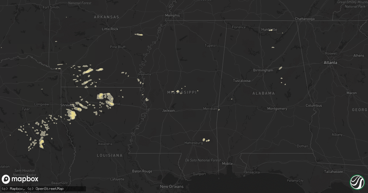
Hail Map in Mississippi on June 1, 2013
Get this storm
June 1 map
$229
one time, instant access
Download today. No call, no setup
Keep the $229
Bought the map and want the full workflow? Apply the entire $229 to a subscription within 7 days. None of it is wasted.
Every map, not just this one
This buys you this map. Subscription and you get every map we run, in the markets you choose from a few cities to whole states to nationwide. Plus real-time alerts the moment a storm fires.
Contact data
Name, contact info, occupancy, even credit band for addresses in the footprint. You go from where it hit to who to call.
Become the source they trust
Unlimited branding weather history reports on demand. You already have the documented answer ready for the property owner, and you are the one who showed up with it.
Property data and RoofTrace estimates
Pull up any address you have got, its value and the exact code rules for that jurisdiction, straight from One Click Code. Then RoofTrace estimates the squares, pitch, and roof value, priced the way you price.
Storm reports in Mississippi
Mississippi
| Date | Description |
|---|---|
| 06/01/20131:20 PM CDT | Tree down across a house at s18th street and ross avenue...est 50mph wind. |
| 06/01/20131:38 AM CDT | Trees down in the north bend area northeast of philadelphia |
| 06/01/201312:40 AM CDT | Several trees down across the county...including scotts crossing rd...ebenezer rd and highway 487 east and west. Power outages occurred in tuscola as well. |
| 06/01/201312:05 AM CDT | Couple trees down on highway 14 |
| 05/31/201311:58 PM CDT | Trees down near flora on hwy 22 and cane creek road. Another tree was down near canton at hart and rankin roads. |
| 05/31/201311:54 PM CDT | Several trees and power lines down around durant |
| 05/31/201311:35 PM CDT | Report of a tree down at 15700 oak ridge road. |
| 05/31/201311:20 PM CDT | Reports of several trees down in and around the vicksburg area. |
All States Impacted by Hail Map on June 1, 2013
Cities Impacted by Hail Map on June 1, 2013
- Fountain Run, KY
- Scottsville, KY
- El Dorado, AR
- Rosston, AR
- Emmet, AR
- Prescott, AR
- Dryden, TX
- Marathon, TX
- Farmerville, LA
- Bernice, LA
- Downsville, LA
- Stephens, AR
- McKean, PA
- Waterford, PA
- Douglass, TX
- Nacogdoches, TX
- Dubach, LA
- Ashdown, AR
- Rocksprings, TX
- Junction, TX
- Junction City, AR
- Mount Hermon, KY
- Tompkinsville, KY
- Camden, AR
- McNeil, AR
- Spring Branch, TX
- Lufkin, TX
- Walnut Springs, TX
- Emerson, AR
- Haynesville, LA
- Gibsland, LA
- Sparta, TN
- Cookeville, TN
- Jonesboro, TX
- Holly Grove, AR
- Brownsboro, AL
- Roe, AR
- Clarendon, AR
- Choudrant, LA
- Homer, LA
- Carthage, TX
- Ringgold, LA
- Mason, TX
- London, TX
- Hampton, AR
- Lewisville, AR
- Stamps, AR
- Kennard, TX
- Ripley, OH
- Maysville, KY
- Aberdeen, OH
- Richton, MS
- Palestine, TX
- Mansfield, LA
- Ozona, TX
- Chireno, TX
- Elm Grove, LA
- Pell City, AL
- Riverside, AL
- Lincoln, AL
- Talladega, AL
- Oakwood, TX
- Portland, AR
- Lake Village, AR
- Eudora, AR
- Groveton, TX
- Mullin, TX
- Mena, AR
- Camden, MS
- Cushing, TX
- Kopperl, TX
- Cranfills Gap, TX
- Fulton, AR
- Iraan, TX
- Sheffield, TX
- Elkhart, TX
- Hamilton, TX
- Simsboro, LA
- Arcadia, LA
- Caney, OK
- Reklaw, TX
- Laneville, TX
- Dripping Springs, TX
- Early, TX
- Eros, LA
- Tenaha, TX
- Seymour, WI
- Pulaski, WI
- Goodwater, AL
- Mount Enterprise, TX
- Henderson, TX
- Shreveport, LA
- Grand Cane, LA
- Frierson, LA
- Brooksville, FL
- Calhoun, LA
- West Monroe, LA
- Georgetown, KY
- Booneville, AR
- Monticello, AR
- Fountain Hill, AR
- Boerne, TX
- Helotes, TX
- San Antonio, TX
- Taylor, AR
- Bandera, TX
- Medina, TX
- Tarpley, TX
- Pennington, TX
- Ruston, LA
- Fort Stockton, TX
- Leakey, TX
- Logansport, LA
- Scottsboro, AL
- Stamping Ground, KY
- Philadelphia, MS
- Santa Anna, TX
- Keatchie, LA
- Goldthwaite, TX
- Harrodsburg, KY
- Bossier City, LA
- Driftwood, TX
- Pulaski, TN
- Gatesville, TX
- Garrison, TX
- Magnolia, AR
- Gustine, TX
- Black Creek, WI
- Caddo, OK
- Buckner, AR
- Bastrop, LA
- Collinston, LA
- Hope, AR
- Comanche, TX
- Grapeland, TX
- Priddy, TX
- Minden, LA
- Iredell, TX
- Midkiff, TX
- Diboll, TX
- Jacksonville, TX
- Chatham, MS
- Montrose, AR
- Boligee, AL
- Doyline, LA
- Sibley, LA
- Heflin, LA
- Shiocton, WI
- Nichols, WI
- Bonduel, WI
- Texarkana, TX
- Jonesboro, LA
- Bienville, LA
- Pickens, MS
- Waldo, AR
- Cuba, AL
- Huntsville, AL
- Gary, TX
- Chidester, AR
- Mayersville, MS
- Rusk, TX
- Alto, TX
- Daingerfield, TX
- Lone Star, TX
- Goodman, MS
- Sallis, MS
- Quitman, LA
- Kosciusko, MS
- D Hanis, TX
- Long Branch, TX
- Pollok, TX
- Coleman, TX
- Trinity, TX
- Timpson, TX
- Johnson City, TX
- Haughton, LA
- Jamestown, LA
- Dubberly, LA
- Mayslick, KY
- Apple Springs, TX
- Blanket, TX
- Stuttgart, AR
- Valley Park, MS
- Hye, TX
- Horton, AL
- Blountsville, AL
- Blanco, TX
- Kendalia, TX
- Rolling Fork, MS
- Gloster, LA
- Keithville, LA
- Stonewall, LA
- Marion, LA
- Hooks, TX


