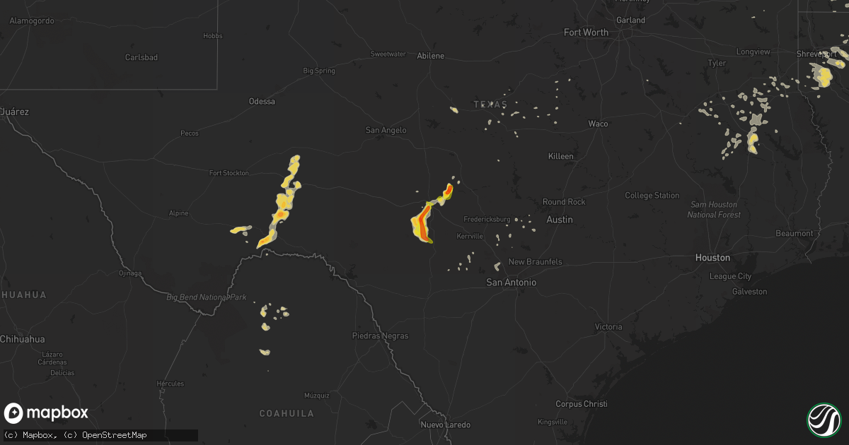
Hail Map on June 1, 2013
Get this storm
June 1 map
$229
one time, instant access
Download today. No call, no setup
Keep the $229
Bought the map and want the full workflow? Apply the entire $229 to a subscription within 7 days. None of it is wasted.
Every map, not just this one
This buys you this map. Subscription and you get every map we run, in the markets you choose from a few cities to whole states to nationwide. Plus real-time alerts the moment a storm fires.
Contact data
Name, contact info, occupancy, even credit band for addresses in the footprint. You go from where it hit to who to call.
Become the source they trust
Unlimited branding weather history reports on demand. You already have the documented answer ready for the property owner, and you are the one who showed up with it.
Property data and RoofTrace estimates
Pull up any address you have got, its value and the exact code rules for that jurisdiction, straight from One Click Code. Then RoofTrace estimates the squares, pitch, and roof value, priced the way you price.
States Impacted by Hail Map on June 1, 2013
Storm reports
Alabama
| Date | Description |
|---|---|
| 06/01/20136:17 PM CDT | Tree down across wimbledon road. Time estimated from radar. |
| 06/01/20134:42 PM CDT | A few trees were blown down in sporadic locations in eastern and northern clay county. Winds estimated around 50 mph. |
| 05/31/20137:00 PM CDT | Tree down across the road near the intersection of al hwy 79 and cox gap rd. |
Kentucky
| Date | Description |
|---|---|
| 06/01/20135:52 PM CDT | Large tree limb on a car at liberty road and fortune drive |
| 06/01/20135:35 PM CDT | Trees and power lines down |
| 06/01/20135:10 PM CDT | A local report indicates 1.00 inch wind near OXFORD |
Arkansas
| Date | Description |
|---|---|
| 06/01/20136:24 PM CDT | Powerlines were downed between holly grove and clarendon near east lake. People were trapped in a house but are out now. |
| 06/01/20139:30 AM CDT | Severe winds resulted in damage within the jonesboro city limits. Windows on a church van were damaged along north main street. A restaurant along e. Word street report |
| 06/01/20139:00 AM CDT | Large trees were blown down near oak grove and sunshine road. |
| 05/31/20137:50 PM CDT | Two trees bent down... And large limbs down... Power lines down... Flooding in low lying areas... Ponding on roads |
| 05/31/20137:40 PM CDT | Tree down on hwy 15 |
| 05/31/20137:24 PM CDT | Powerlines were downed between holly grove and clarendon near east lake. People were trapped in a house but are out now. |
Maine
| Date | Description |
|---|---|
| 06/01/20132:35 PM CDT | Trees down with some trees snapped off half up. |
| 06/01/20131:55 PM CDT | Wires and trees down in greenville. Several power poles knocked down and many homes without power. |
Texas
| Date | Description |
|---|---|
| 06/01/20134:50 AM CDT | Pin oak tree with a ten inch dia. Trunk broken off at about six inches from the ground. Several branches from nearby trees also broken. |
| 05/31/201311:25 PM CDT | High winds coming from several directions. |
| 05/31/201311:00 PM CDT | Nickel to golf ball size hail. |
| 05/31/201310:30 PM CDT | Golf ball size hail reported just north of the kimble and edwards county line on the 700 springs ranch |
| 05/31/20139:52 PM CDT | Quarter size hail reported at llano state park. |
| 05/31/20139:50 PM CDT | A local report indicates 1.00 inch wind near JUNCTION |
| 05/31/20139:47 PM CDT | A local report indicates 1.00 inch wind near 1 W JUNCTION |
| 05/31/20139:30 PM CDT | Dime size to quarter size hail reported at the days inn at mile marker 457. |
| 05/31/20138:48 PM CDT | Quarter size hail reported at blue mountain peak ranch |
| 05/31/20138:24 PM CDT | A local report indicates 1.75 inch wind near 5 SSE ERNA |
| 05/31/20137:42 PM CDT | The hail continued until 742 pm before ending. The largest hailstones were the size of quarters. |
| 05/31/20137:35 PM CDT | Mainly half inch hail with a few hailstones to the size of quarters. |
Ohio
| Date | Description |
|---|---|
| 06/01/201312:05 AM CDT | One tree down in the twin lakes area |
Vermont
| Date | Description |
|---|---|
| 05/31/20138:43 PM CDT | Tree down on buck hollow road |
New York
| Date | Description |
|---|---|
| 06/01/20136:30 PM CDT | Couple trees down |
| 06/01/20136:23 PM CDT | Trees down. |
| 06/01/20136:20 PM CDT | Trees and wires down. |
| 06/01/20136:03 PM CDT | Trees down on besha rd. |
| 06/01/20135:54 PM CDT | Trees down on resha rd. |
| 06/01/20135:25 PM CDT | Downed tree brought down power lines. |
| 06/01/20135:25 PM CDT | Trees down. |
| 06/01/20135:06 PM CDT | Multiple trees down. |
| 06/01/20135:06 PM CDT | Trees down in belleville... Near ellisburg ny. |
| 05/31/201310:57 PM CDT | Tree down across road. |
| 05/31/20138:25 PM CDT | Tree down on south shore road. |
| 05/31/20138:03 PM CDT | Tree down |
| 05/31/20137:44 PM CDT | 2 trees down |
| 05/31/20137:12 PM CDT | Trees down on besha rd. |
| 05/31/20137:12 PM CDT | Trees down on resha rd. |
| 05/31/20137:10 PM CDT | Trees down. |
| 05/31/20137:00 PM CDT | Tree down on power lines |
Louisiana
| Date | Description |
|---|---|
| 05/31/201310:30 PM CDT | Large tree down in west monroe. |
| 05/31/201310:15 PM CDT | Tree down on goodhope road |
| 05/31/201310:12 PM CDT | Quarter size hail reported in the vicinity of the ouachita parish fire training center on new natchitoches road near bawcomville. |
| 05/31/20139:50 PM CDT | Multiple trees down along hwy 138. |
| 05/31/20139:03 PM CDT | Trees reported down across the parish |
| 05/31/20139:00 PM CDT | Multiple trees down in wide area of southeastern portion of parish |
| 05/31/20138:50 PM CDT | Trees snapped and uprooted |
| 05/31/20138:45 PM CDT | Tree down 2 miles se of town |
| 05/31/20138:42 PM CDT | Tree down 1w of town |
| 05/31/20137:40 PM CDT | Tree down on alternate hwy 2 |
Tennessee
| Date | Description |
|---|---|
| 06/01/20136:21 PM CDT | Downed trees reported in the dodson branch area north of cookeville |
| 06/01/20136:04 PM CDT | Several trees were snapped in beechgrove. |
| 06/01/20134:20 PM CDT | Tree down at 206 elm street in nashville |
| 06/01/20134:15 PM CDT | Tree down on powerline |
| 06/01/20134:15 PM CDT | Tree down on lickton pike in madison |
| 06/01/20134:00 PM CDT | Tree down on powerline |
Mississippi
| Date | Description |
|---|---|
| 06/01/20131:20 PM CDT | Tree down across a house at s18th street and ross avenue...est 50mph wind. |
| 06/01/20131:38 AM CDT | Trees down in the north bend area northeast of philadelphia |
| 06/01/201312:40 AM CDT | Several trees down across the county...including scotts crossing rd...ebenezer rd and highway 487 east and west. Power outages occurred in tuscola as well. |
| 06/01/201312:05 AM CDT | Couple trees down on highway 14 |
| 05/31/201311:58 PM CDT | Trees down near flora on hwy 22 and cane creek road. Another tree was down near canton at hart and rankin roads. |
| 05/31/201311:54 PM CDT | Several trees and power lines down around durant |
| 05/31/201311:35 PM CDT | Report of a tree down at 15700 oak ridge road. |
| 05/31/201311:20 PM CDT | Reports of several trees down in and around the vicksburg area. |
Cities Impacted by Hail Map on June 1, 2013
- Fountain Run, KY
- Scottsville, KY
- El Dorado, AR
- Rosston, AR
- Emmet, AR
- Prescott, AR
- Dryden, TX
- Marathon, TX
- Farmerville, LA
- Bernice, LA
- Downsville, LA
- Stephens, AR
- McKean, PA
- Waterford, PA
- Douglass, TX
- Nacogdoches, TX
- Dubach, LA
- Ashdown, AR
- Rocksprings, TX
- Junction, TX
- Junction City, AR
- Mount Hermon, KY
- Tompkinsville, KY
- Camden, AR
- McNeil, AR
- Spring Branch, TX
- Lufkin, TX
- Walnut Springs, TX
- Emerson, AR
- Haynesville, LA
- Gibsland, LA
- Sparta, TN
- Cookeville, TN
- Jonesboro, TX
- Holly Grove, AR
- Brownsboro, AL
- Roe, AR
- Clarendon, AR
- Choudrant, LA
- Homer, LA
- Carthage, TX
- Ringgold, LA
- Mason, TX
- London, TX
- Hampton, AR
- Lewisville, AR
- Stamps, AR
- Kennard, TX
- Ripley, OH
- Maysville, KY
- Aberdeen, OH
- Richton, MS
- Palestine, TX
- Mansfield, LA
- Ozona, TX
- Chireno, TX
- Elm Grove, LA
- Pell City, AL
- Riverside, AL
- Lincoln, AL
- Talladega, AL
- Oakwood, TX
- Portland, AR
- Lake Village, AR
- Eudora, AR
- Groveton, TX
- Mullin, TX
- Mena, AR
- Camden, MS
- Cushing, TX
- Kopperl, TX
- Cranfills Gap, TX
- Fulton, AR
- Iraan, TX
- Sheffield, TX
- Elkhart, TX
- Hamilton, TX
- Simsboro, LA
- Arcadia, LA
- Caney, OK
- Reklaw, TX
- Laneville, TX
- Dripping Springs, TX
- Early, TX
- Eros, LA
- Tenaha, TX
- Seymour, WI
- Pulaski, WI
- Goodwater, AL
- Mount Enterprise, TX
- Henderson, TX
- Shreveport, LA
- Grand Cane, LA
- Frierson, LA
- Brooksville, FL
- Calhoun, LA
- West Monroe, LA
- Georgetown, KY
- Booneville, AR
- Monticello, AR
- Fountain Hill, AR
- Boerne, TX
- Helotes, TX
- San Antonio, TX
- Taylor, AR
- Bandera, TX
- Medina, TX
- Tarpley, TX
- Pennington, TX
- Ruston, LA
- Fort Stockton, TX
- Leakey, TX
- Logansport, LA
- Scottsboro, AL
- Stamping Ground, KY
- Philadelphia, MS
- Santa Anna, TX
- Keatchie, LA
- Goldthwaite, TX
- Harrodsburg, KY
- Bossier City, LA
- Driftwood, TX
- Pulaski, TN
- Gatesville, TX
- Garrison, TX
- Magnolia, AR
- Gustine, TX
- Black Creek, WI
- Caddo, OK
- Buckner, AR
- Bastrop, LA
- Collinston, LA
- Hope, AR
- Comanche, TX
- Grapeland, TX
- Priddy, TX
- Minden, LA
- Iredell, TX
- Midkiff, TX
- Diboll, TX
- Jacksonville, TX
- Chatham, MS
- Montrose, AR
- Boligee, AL
- Doyline, LA
- Sibley, LA
- Heflin, LA
- Shiocton, WI
- Nichols, WI
- Bonduel, WI
- Texarkana, TX
- Jonesboro, LA
- Bienville, LA
- Pickens, MS
- Waldo, AR
- Cuba, AL
- Huntsville, AL
- Gary, TX
- Chidester, AR
- Mayersville, MS
- Rusk, TX
- Alto, TX
- Daingerfield, TX
- Lone Star, TX
- Goodman, MS
- Sallis, MS
- Quitman, LA
- Kosciusko, MS
- D Hanis, TX
- Long Branch, TX
- Pollok, TX
- Coleman, TX
- Trinity, TX
- Timpson, TX
- Johnson City, TX
- Haughton, LA
- Jamestown, LA
- Dubberly, LA
- Mayslick, KY
- Apple Springs, TX
- Blanket, TX
- Stuttgart, AR
- Valley Park, MS
- Hye, TX
- Horton, AL
- Blountsville, AL
- Blanco, TX
- Kendalia, TX
- Rolling Fork, MS
- Gloster, LA
- Keithville, LA
- Stonewall, LA
- Marion, LA
- Hooks, TX