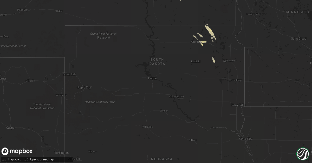
Hail Map in South Dakota on June 1, 2012
Get this storm
June 1 map
$229
one time, instant access
Download today. No call, no setup
Keep the $229
Bought the map and want the full workflow? Apply the entire $229 to a subscription within 7 days. None of it is wasted.
Every map, not just this one
This buys you this map. Subscription and you get every map we run, in the markets you choose from a few cities to whole states to nationwide. Plus real-time alerts the moment a storm fires.
Contact data
Name, contact info, occupancy, even credit band for addresses in the footprint. You go from where it hit to who to call.
Become the source they trust
Unlimited branding weather history reports on demand. You already have the documented answer ready for the property owner, and you are the one who showed up with it.
Property data and RoofTrace estimates
Pull up any address you have got, its value and the exact code rules for that jurisdiction, straight from One Click Code. Then RoofTrace estimates the squares, pitch, and roof value, priced the way you price.
Storm reports in South Dakota
South Dakota
| Date | Description |
|---|---|
| 06/01/20126:30 PM CDT | A local report indicates 1.00 inch wind near 6 W BRITTON |
| 06/01/20126:25 PM CDT | Hail was accompanied by estimated 30-40 mph winds |
| 06/01/20126:15 PM CDT | A local report indicates 1.00 inch wind near 6 NE STRATFORD |
| 06/01/20125:50 PM CDT | A local report indicates 1.00 inch wind near BATH |
| 06/01/20125:27 PM CDT | Brief touchdown |
| 06/01/20125:00 PM CDT | A local report indicates 1.00 inch wind near 3 SW WESTPORT |
| 05/31/20129:14 PM CDT | A local report indicates a tornado near 3 S WILLOW LAKE |
| 05/31/20128:48 PM CDT | A local report indicates a tornado near 5 N WILLOW LAKE |
| 05/31/20128:02 PM CDT | A local report indicates 1.00 inch wind near CLARK |
| 05/31/20127:59 PM CDT | A local report indicates a tornado near 3 E RAYMOND |
| 05/31/20127:05 PM CDT | A local report indicates 1.00 inch wind near 6 E LANGFORD |
All States Impacted by Hail Map on June 1, 2012
Cities Impacted by Hail Map on June 1, 2012
- Roanoke Rapids, NC
- Efland, NC
- Mebane, NC
- Cedar Grove, NC
- Como, NC
- Newsoms, VA
- Franklin, VA
- Britton, SD
- Amherst, SD
- Claremont, SD
- Hecla, SD
- Langford, SD
- Tulia, TX
- Wayside, TX
- Happy, TX
- Rosston, OK
- Orange, VA
- Pleasant Hill, NC
- Gaston, NC
- Garysburg, NC
- Weldon, NC
- Canyon, TX
- Panhandle, TX
- Kress, TX
- Claude, TX
- Amarillo, TX
- Groom, TX
- Booker, TX
- Follett, TX
- Kismet, KS
- Turpin, OK
- Forgan, OK
- Plains, KS
- Hugoton, KS
- Liberal, KS
- Greensboro, NC
- Courtland, VA
- Pendleton, NC
- Carrsville, VA
- Windsor, VA
- Zuni, VA
- Suffolk, VA
- Fargo, OK
- Sharon, OK
- Woodward, OK
- Glen Arm, MD
- Lutherville Timonium, MD
- Towson, MD
- Baltimore, MD
- Parkville, MD
- Wellington, TX
- Hollis, OK
- Dalhart, TX
- Dillwyn, VA
- Cumberland, VA
- Portsmouth, VA
- Chesapeake, VA
- Walterboro, SC
- Monroe, VA
- Rolette, ND
- Mosquero, NM
- Saint John, ND
- Belcourt, ND
- Jackson, NC
- Enfield, NC
- Rich Square, NC
- Halifax, NC
- Scotland Neck, NC
- Hartley, TX
- Laverne, OK
- Gate, OK
- Meade, KS
- Haw River, NC
- Wheeler, TX
- Shamrock, TX
- Littleton, NC
- Hereford, TX
- Friona, TX
- Arrington, VA
- Roseland, VA
- Amherst, VA
- Adrian, TX
- Beaver, OK
- Nashville, NC
- Battleboro, NC
- Whitakers, NC
- Rocky Mount, NC
- Spring Hope, NC
- Bailey, NC
- Shattuck, OK
- Vega, TX
- Warfordsburg, PA
- Hancock, MD
- Artemas, PA
- Flintstone, MD
- Little Orleans, MD
- Great Cacapon, WV
- Ruidoso Downs, NM
- Jessup, MD
- Savage, MD
- Fulton, MD
- Fort George G Meade, MD
- Burtonsville, MD
- Ellicott City, MD
- Hanover, MD
- Columbia, MD
- Clarksville, MD
- Elkridge, MD
- Annapolis Junction, MD
- Laurel, MD
- Gould, OK
- Cleveland, ND
- Gackle, ND
- Silver Spring, MD
- Westport, SD
- Round O, SC
- Dodson, TX
- Edenton, NC
- Sweetwater, OK
- Mineral, VA
- Alturas, CA
- San Jon, NM
- Roslyn, SD
- Pampa, TX
- Palmyra, VA
- Scottsville, VA
- Raton, NM
- Graham, NC
- Rugby, ND
- Lovingston, VA
- Covesville, VA
- Piney River, VA
- Shipman, VA
- Faber, VA
- North Garden, VA
- Clarendon, NC
- Tabor City, NC
- Chadbourn, NC
- Whiteville, NC
- Loris, SC
- Green Sea, SC
- Guymon, OK
- Skippers, VA
- Farnham, VA
- Heathsville, VA
- Hillsborough, NC
- Timberlake, NC
- Rougemont, NC
- Roxboro, NC
- Hurdle Mills, NC
- Clarkton, NC
- Elizabethtown, NC
- Bladenboro, NC
- Four Oaks, NC
- Pierpont, SD
- Dunn, NC
- Newton Grove, NC
- Benson, NC
- Smithfield, NC
- Columbia, SD
- Mclean, TX
- Texhoma, OK
- Bard, NM
- Clayton, NC
- Selma, NC
- Lexington, VA
- Buena Vista, VA
- Mobeetie, TX
- Canadian, TX
- Eldorado, OK
- Quanah, TX
- Briscoe, TX
- Quail, TX
- Nesmith, SC
- Dunseith, ND
- Thomasville, NC
- Trinity, NC
- High Point, NC
- Elizabeth City, NC
- Camden, NC
- Logan, NM
- Nara Visa, NM
- Clark, SD
- Childress, TX
- New Canton, VA
- Whitsett, NC
- Warrenton, NC
- Boydton, VA
- Norlina, NC
- Manson, NC
- Appomattox, VA
- Phenix, VA
- Red House, VA
- Brookneal, VA
- Keyes, OK
- Oakes, ND
- Gordonsville, VA
- Barboursville, VA
- Goochland, VA
- Buckingham, VA
- Columbia, VA
- Arvonia, VA
- Takoma Park, MD
- Hyattsville, MD
- College Park, MD
- Lanham, MD
- Groton, SD
- Bath, SD
- Catonsville, MD
- Bowie, MD
- Halethorpe, MD
- Severn, MD
- Gwynn Oak, MD
- Glenn Dale, MD
- Beltsville, MD
- Oxford, NC
- Brandy Station, VA
- Culpeper, VA
- Capitan, NM
- Gladstone, VA
- Fredericksburg, VA
- Merry Hill, NC
- Early Branch, SC
- Yemassee, SC
- Charlottesville, VA
- Ruffin, SC
- Guthrie, OK
- Geary, OK
- Reydon, OK
- Baskerville, VA
- Nazareth, TX
- Hertford, NC
- Macon, NC
- La Crosse, VA
- South Hill, VA
- Roy, NM
- Henderson, NC
- White Oak, NC
- Brodnax, VA
- Englewood, KS
- Bassett, NE
- Pamplin, VA
- Madison Heights, VA
- Randleman, NC
- Pleasant Garden, NC
- Climax, NC
- Garland, NC
- Fayetteville, NC
- Dickerson, MD
- Barnesville, MD
- Beallsville, MD
- Princeton, NC
- Jamestown, NC
- McLeansville, NC
- Needmore, PA
- Big Cove Tannery, PA
- Concord, VA
- Hedley, TX
- King And Queen Court House, VA
- Burlington, NC
- Lancaster, PA
- Ruidoso, NM
- Nokesville, VA
- Spotsylvania, VA
- Aulander, NC
- Sayre, OK
- Evergreen, NC
- Gum Spring, VA
- Sandy Hook, VA
- Stem, NC
- Webster, SD
- Bracey, VA
- Calumet, OK
- Radiant, VA
- Plymouth, NC
- Windsor, NC
- Hollister, NC
- Castalia, NC
- Seiling, OK
- Woodland, NC
- Boykins, VA
- Conway, NC
- Roxobel, NC
- Smithfield, VA
- Margarettsville, NC
- Murfreesboro, NC
- Ahoskie, NC
- Clarksburg, MD
- Ijamsville, MD
- Aberdeen, SD
- Cheyenne, OK
- Erick, OK
- Springer, NM
- Somerset, VA
- Rapidan, VA
- Glencoe, NM
- Sophia, NC
- Emporia, VA
- Jarratt, VA


