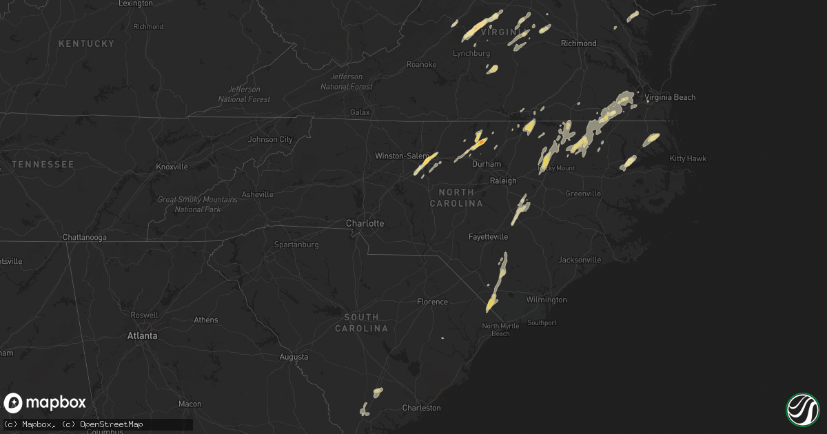
Hail Map in North Carolina on June 1, 2012
Get this storm
June 1 map
$229
one time, instant access
Download today. No call, no setup
Keep the $229
Bought the map and want the full workflow? Apply the entire $229 to a subscription within 7 days. None of it is wasted.
Every map, not just this one
This buys you this map. Subscription and you get every map we run, in the markets you choose from a few cities to whole states to nationwide. Plus real-time alerts the moment a storm fires.
Contact data
Name, contact info, occupancy, even credit band for addresses in the footprint. You go from where it hit to who to call.
Become the source they trust
Unlimited branding weather history reports on demand. You already have the documented answer ready for the property owner, and you are the one who showed up with it.
Property data and RoofTrace estimates
Pull up any address you have got, its value and the exact code rules for that jurisdiction, straight from One Click Code. Then RoofTrace estimates the squares, pitch, and roof value, priced the way you price.
Storm reports in North Carolina
North Carolina
| Date | Description |
|---|---|
| 06/01/20125:08 PM CDT | 4 trees down near us highway 401 just north of warrenton |
| 06/01/20124:42 PM CDT | Several trees down in the white oak neighborhood |
| 06/01/20124:30 PM CDT | County 911 center reports numerous trees down across the northern part of the county. |
| 06/01/20124:30 PM CDT | Trees down along pritchard street |
| 06/01/20124:20 PM CDT | Tree on a house at 507 boddie street. Time estimated from radar. |
| 06/01/20124:18 PM CDT | Officer reported tornado on the ground just north of highway 17. Tornado lifted after several minutes but rotation was still evident. |
| 06/01/20124:08 PM CDT | Trees down in multiple locations all over southern nash county |
| 06/01/20123:44 PM CDT | Tree fell onto a mobile home |
| 06/01/20123:35 PM CDT | Power pole blown down onto a car at a car dealership. |
| 06/01/20123:24 PM CDT | Quarter size hail reported at hwy 701 and stricklands crossroads road |
| 06/01/20123:05 PM CDT | Golf ball size hail |
| 06/01/20122:44 PM CDT | Several small trees and larger limbs down at 4544 beaver dam church road |
| 06/01/20122:35 PM CDT | Trees down on germanton road. One tree on a house. Approx. 1500 power outages. |
| 06/01/20122:30 PM CDT | Trees down on shattelon drive. |
| 06/01/20122:25 PM CDT | Quarter size hail... Trees down |
| 06/01/20122:21 PM CDT | A local report indicates 1.00 inch wind near ELIZABETHTOWN |
| 06/01/20122:15 PM CDT | Trees down in hester park |
| 06/01/20122:15 PM CDT | Multiple trees down and windows broken in the vicinity of peck elementary school... Time estimated |
| 06/01/20122:10 PM CDT | Numerous trees down in greensboro. Elm street... Summit ave... And sunset drive hardest hit. |
| 06/01/20121:52 PM CDT | Tree down at 1309 old lumberton road. |
| 06/01/20121:50 PM CDT | Quarter size hail at the four seasons town centre |
| 06/01/20121:48 PM CDT | Tree down on hwy 74. |
| 06/01/20121:48 PM CDT | Golf ball size hail at unc greensboro |
| 06/01/20121:45 PM CDT | A combination of wind and hail sent large limbs down on a vehicle. A flag pole was bent over. There was minor damage to a building. |
| 06/01/20121:45 PM CDT | Several trees down in the city of high point |
| 06/01/20121:38 PM CDT | Two trees reported down with one tree causing damage to a house. |
| 06/01/20121:27 PM CDT | A local report indicates 1.00 inch wind near 2 SSE BOONES CROSSROADS |
| 06/01/20121:05 PM CDT | Quarter size hail that lasted 5 to 10 minutes |
| 06/01/201212:50 PM CDT | Roof blown off shed. Trees snapped off. |
| 06/01/201212:45 PM CDT | Lots of debris on hwy 48...leaves...small branches and small pine tree on powerline |
| 06/01/201212:45 PM CDT | Large tree down on hwy-98. Tree fell across power lines creating large swath of power outages in northern wake county. |
| 06/01/201212:40 PM CDT | Tree down and blocking the road at piney grove church road and hwy 903 |
| 06/01/201212:40 PM CDT | Tree down blocking country club road... Time estimated by radar |
| 06/01/201212:32 PM CDT | Tree down blocking both lanes of road at tanner road and justice branch road... Time estimated by radar |
| 06/01/201212:28 PM CDT | A large pine tree...50-60 ft tall and 12 inches in diameter...fell at old watkins and forestville roads. |
| 06/01/201211:50 AM CDT | Large limbs blown down at coolspring and tower roads... Time estimated |
All States Impacted by Hail Map on June 1, 2012
Cities Impacted by Hail Map on June 1, 2012
- Roanoke Rapids, NC
- Efland, NC
- Mebane, NC
- Cedar Grove, NC
- Como, NC
- Newsoms, VA
- Franklin, VA
- Britton, SD
- Amherst, SD
- Claremont, SD
- Hecla, SD
- Langford, SD
- Tulia, TX
- Wayside, TX
- Happy, TX
- Rosston, OK
- Orange, VA
- Pleasant Hill, NC
- Gaston, NC
- Garysburg, NC
- Weldon, NC
- Canyon, TX
- Panhandle, TX
- Kress, TX
- Claude, TX
- Amarillo, TX
- Groom, TX
- Booker, TX
- Follett, TX
- Kismet, KS
- Turpin, OK
- Forgan, OK
- Plains, KS
- Hugoton, KS
- Liberal, KS
- Greensboro, NC
- Courtland, VA
- Pendleton, NC
- Carrsville, VA
- Windsor, VA
- Zuni, VA
- Suffolk, VA
- Fargo, OK
- Sharon, OK
- Woodward, OK
- Glen Arm, MD
- Lutherville Timonium, MD
- Towson, MD
- Baltimore, MD
- Parkville, MD
- Wellington, TX
- Hollis, OK
- Dalhart, TX
- Dillwyn, VA
- Cumberland, VA
- Portsmouth, VA
- Chesapeake, VA
- Walterboro, SC
- Monroe, VA
- Rolette, ND
- Mosquero, NM
- Saint John, ND
- Belcourt, ND
- Jackson, NC
- Enfield, NC
- Rich Square, NC
- Halifax, NC
- Scotland Neck, NC
- Hartley, TX
- Laverne, OK
- Gate, OK
- Meade, KS
- Haw River, NC
- Wheeler, TX
- Shamrock, TX
- Littleton, NC
- Hereford, TX
- Friona, TX
- Arrington, VA
- Roseland, VA
- Amherst, VA
- Adrian, TX
- Beaver, OK
- Nashville, NC
- Battleboro, NC
- Whitakers, NC
- Rocky Mount, NC
- Spring Hope, NC
- Bailey, NC
- Shattuck, OK
- Vega, TX
- Warfordsburg, PA
- Hancock, MD
- Artemas, PA
- Flintstone, MD
- Little Orleans, MD
- Great Cacapon, WV
- Ruidoso Downs, NM
- Jessup, MD
- Savage, MD
- Fulton, MD
- Fort George G Meade, MD
- Burtonsville, MD
- Ellicott City, MD
- Hanover, MD
- Columbia, MD
- Clarksville, MD
- Elkridge, MD
- Annapolis Junction, MD
- Laurel, MD
- Gould, OK
- Cleveland, ND
- Gackle, ND
- Silver Spring, MD
- Westport, SD
- Round O, SC
- Dodson, TX
- Edenton, NC
- Sweetwater, OK
- Mineral, VA
- Alturas, CA
- San Jon, NM
- Roslyn, SD
- Pampa, TX
- Palmyra, VA
- Scottsville, VA
- Raton, NM
- Graham, NC
- Rugby, ND
- Lovingston, VA
- Covesville, VA
- Piney River, VA
- Shipman, VA
- Faber, VA
- North Garden, VA
- Clarendon, NC
- Tabor City, NC
- Chadbourn, NC
- Whiteville, NC
- Loris, SC
- Green Sea, SC
- Guymon, OK
- Skippers, VA
- Farnham, VA
- Heathsville, VA
- Hillsborough, NC
- Timberlake, NC
- Rougemont, NC
- Roxboro, NC
- Hurdle Mills, NC
- Clarkton, NC
- Elizabethtown, NC
- Bladenboro, NC
- Four Oaks, NC
- Pierpont, SD
- Dunn, NC
- Newton Grove, NC
- Benson, NC
- Smithfield, NC
- Columbia, SD
- Mclean, TX
- Texhoma, OK
- Bard, NM
- Clayton, NC
- Selma, NC
- Lexington, VA
- Buena Vista, VA
- Mobeetie, TX
- Canadian, TX
- Eldorado, OK
- Quanah, TX
- Briscoe, TX
- Quail, TX
- Nesmith, SC
- Dunseith, ND
- Thomasville, NC
- Trinity, NC
- High Point, NC
- Elizabeth City, NC
- Camden, NC
- Logan, NM
- Nara Visa, NM
- Clark, SD
- Childress, TX
- New Canton, VA
- Whitsett, NC
- Warrenton, NC
- Boydton, VA
- Norlina, NC
- Manson, NC
- Appomattox, VA
- Phenix, VA
- Red House, VA
- Brookneal, VA
- Keyes, OK
- Oakes, ND
- Gordonsville, VA
- Barboursville, VA
- Goochland, VA
- Buckingham, VA
- Columbia, VA
- Arvonia, VA
- Takoma Park, MD
- Hyattsville, MD
- College Park, MD
- Lanham, MD
- Groton, SD
- Bath, SD
- Catonsville, MD
- Bowie, MD
- Halethorpe, MD
- Severn, MD
- Gwynn Oak, MD
- Glenn Dale, MD
- Beltsville, MD
- Oxford, NC
- Brandy Station, VA
- Culpeper, VA
- Capitan, NM
- Gladstone, VA
- Fredericksburg, VA
- Merry Hill, NC
- Early Branch, SC
- Yemassee, SC
- Charlottesville, VA
- Ruffin, SC
- Guthrie, OK
- Geary, OK
- Reydon, OK
- Baskerville, VA
- Nazareth, TX
- Hertford, NC
- Macon, NC
- La Crosse, VA
- South Hill, VA
- Roy, NM
- Henderson, NC
- White Oak, NC
- Brodnax, VA
- Englewood, KS
- Bassett, NE
- Pamplin, VA
- Madison Heights, VA
- Randleman, NC
- Pleasant Garden, NC
- Climax, NC
- Garland, NC
- Fayetteville, NC
- Dickerson, MD
- Barnesville, MD
- Beallsville, MD
- Princeton, NC
- Jamestown, NC
- McLeansville, NC
- Needmore, PA
- Big Cove Tannery, PA
- Concord, VA
- Hedley, TX
- King And Queen Court House, VA
- Burlington, NC
- Lancaster, PA
- Ruidoso, NM
- Nokesville, VA
- Spotsylvania, VA
- Aulander, NC
- Sayre, OK
- Evergreen, NC
- Gum Spring, VA
- Sandy Hook, VA
- Stem, NC
- Webster, SD
- Bracey, VA
- Calumet, OK
- Radiant, VA
- Plymouth, NC
- Windsor, NC
- Hollister, NC
- Castalia, NC
- Seiling, OK
- Woodland, NC
- Boykins, VA
- Conway, NC
- Roxobel, NC
- Smithfield, VA
- Margarettsville, NC
- Murfreesboro, NC
- Ahoskie, NC
- Clarksburg, MD
- Ijamsville, MD
- Aberdeen, SD
- Cheyenne, OK
- Erick, OK
- Springer, NM
- Somerset, VA
- Rapidan, VA
- Glencoe, NM
- Sophia, NC
- Emporia, VA
- Jarratt, VA


