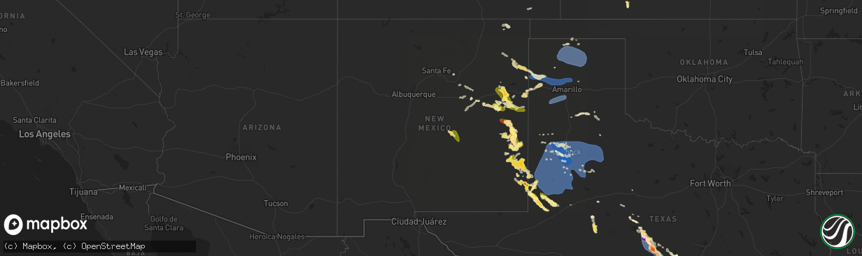
Hail Map in New Mexico on May 31, 2024
The weather event in New Mexico on May 31, 2024 includes Wind and Hail maps. 9 states and 301 cities were impacted and suffered possible damage. The total estimated number of properties impacted is 28,084.
Want more than just the map?
Turn this storm into a full workflow.
- Owner + property data so you know who to knock
- OnDemand branded weather history reports to win the "did we even have hail?" argument
- RoofTrace estimate so reps stop guessing numbers at the door
Bought this map? Upgrade within 7 days and we'll credit the $230. (10-15 min setup call)
Wind
Hail
28,084
Estimated number of impacted properties by a 1.00" hail or larger10,864
Estimated number of impacted properties by a 1.75" hail or larger5,144
Estimated number of impacted properties by a 2.50" hail or largerStorm reports in New Mexico
New Mexico
| Date | Description |
|---|---|
| 05/31/20246:50 PM CDT | Spotter reported lots of penny to quarter size hail. |
| 05/30/202411:08 PM CDT | Hail up to the size of tennis balls was called in by retired spotter/emergency manager david hooten for the city of hobbs near taos... Copper... And grimes streets. |
| 05/30/202410:49 PM CDT | 1.75 inch diameter hail reported at 9:49 pm mdt north of hobbs. |
| 05/30/202410:45 PM CDT | Report of golf ball size hail off princess jeanne heading south. |
| 05/30/202410:42 PM CDT | Report of golf ball size hail at bender boulevard and e michigan drive near sanger elementary school. |
| 05/30/202410:37 PM CDT | Hail up to 1 in. In diameter reported at corner of taos and grimes streets. |
| 05/30/20249:52 PM CDT | A local report indicates 1.75 inch wind near 1 NNE Hobbs |
| 05/30/20249:51 PM CDT | A local report indicates 1.50 inch wind near 5 N Hobbs |
| 05/30/20249:47 PM CDT | Pea size hail increasing to quarter size hail observed at time of call. |
| 05/30/20249:43 PM CDT | A local report indicates 59 MPH wind near 2 SW Tatum |
| 05/30/20249:39 PM CDT | Lea county em reported downed powerlines and broken skylights from severe winds and hail in tatum. Time is estimated from radar. |
| 05/30/20249:27 PM CDT | Media relayed a photo of a wind turbine north of tatum on fire. This is likely the result of severe wind gusts. Time is estimated from radar. |
| 05/30/20248:05 PM CDT | Roosevelt county emergency manager reported down utility poles at s cr 33 and s cr p. |
| 05/30/20247:12 PM CDT | Elida fire department reported golf ball size hail. |
All States Impacted by Hail Map on May 31, 2024
Cities Impacted by Hail Map on May 31, 2024
- Louise, TX
- El Campo, TX
- Harper, TX
- Kerrville, TX
- Ingram, TX
- Mountain Home, TX
- Tuscola, TX
- Ganado, TX
- Fredericksburg, TX
- Midfield, TX
- Millersview, TX
- Voss, TX
- Doole, TX
- Bay City, TX
- Markham, TX
- Blessing, TX
- Wingate, TX
- Comfort, TX
- Rosharon, TX
- Manvel, TX
- Palacios, TX
- Dickinson, TX
- Liverpool, TX
- Santa Fe, TX
- Alvin, TX
- Crosby, TX
- Baytown, TX
- Ovalo, TX
- Dayton, TX
- Hitchcock, TX
- Boerne, TX
- New Braunfels, TX
- Center Point, TX
- Seguin, TX
- Kingsbury, TX
- Port O'Connor, TX
- Lolita, TX
- Matagorda, TX
- Elmaton, TX
- Kendalia, TX
- Spring Branch, TX
- Bergheim, TX
- Abilene, TX
- Bishop, TX
- Kingsville, TX
- League City, TX
- Kemah, TX
- Las Vegas, NM
- Bacliff, TX
- Houston, TX
- Webster, TX
- Friendswood, TX
- La Marque, TX
- Texas City, TX
- Seabrook, TX
- Pearland, TX
- Woodville, MS
- Boca Grande, FL
- Coleman, TX
- Gouldbusk, TX
- Lohn, TX
- Talpa, TX
- Rockwood, TX
- Corona, NM
- Folsom, NM
- Ballinger, TX
- Marco Island, FL
- San Saba, TX
- Melrose, NM
- Minneola, KS
- Brady, TX
- Rochelle, TX
- Anton Chico, NM
- Des Moines, NM
- Madison, MS
- Santa Rosa, NM
- Vaughn, NM
- Richland Springs, TX
- Beloit, KS
- Cherokee, TX
- Pritchett, CO
- Barnard, KS
- Strasburg, CO
- Bennett, CO
- Duke, OK
- Seymour, TX
- Crowell, TX
- Shattuck, OK
- Sayre, OK
- Rosston, OK
- Voca, TX
- Floyd, NM
- Fredonia, TX
- Byers, CO
- Mason, TX
- Pontotoc, TX
- Melvin, TX
- Portales, NM
- Deer Trail, CO
- Llano, TX
- Tow, TX
- Conchas Dam, NM
- Sylvan Grove, KS
- Dodge City, KS
- Agate, CO
- Cuervo, NM
- Sterling City, TX
- Bluffton, TX
- Tucumcari, NM
- Valley Spring, TX
- Art, TX
- Buchanan Dam, TX
- Castell, TX
- House, NM
- Burnet, TX
- Elida, NM
- Limon, CO
- Matheson, CO
- Loraine, TX
- Fort Sumner, NM
- Clayton, NM
- Roy, NM
- Kingsland, TX
- Mcalister, NM
- Hunter, KS
- Salina, KS
- Lindsborg, KS
- Marble Falls, TX
- Elbert, CO
- Calhan, CO
- Assaria, KS
- Marquette, KS
- Falun, KS
- Mosquero, NM
- Pep, NM
- Grady, NM
- Hugo, CO
- Colorado Springs, CO
- Bard, NM
- San Jon, NM
- Ramah, CO
- Larkspur, CO
- Gypsum, KS
- Galva, KS
- Simla, CO
- Castle Rock, CO
- Clovis, NM
- Mcpherson, KS
- Nara Visa, NM
- Amistad, NM
- Adrian, TX
- Causey, NM
- Franktown, CO
- Fountain, CO
- Milnesand, NM
- Vona, CO
- Round Mountain, TX
- Johnson City, TX
- Newton, KS
- Moundridge, KS
- Horseshoe Bay, TX
- Inman, KS
- Tatum, NM
- Mertzon, TX
- Crossroads, NM
- Peyton, CO
- Channing, TX
- Hesston, KS
- Halstead, KS
- Sudan, TX
- Vega, TX
- Logan, NM
- Amherst, TX
- Dripping Springs, TX
- Stratton, CO
- Buhler, KS
- Karval, CO
- Stratford, TX
- Rogers, NM
- North Newton, KS
- Littlefield, TX
- Boone, CO
- Hutchinson, KS
- Burrton, KS
- Gruver, TX
- Sedgwick, KS
- Pep, TX
- Dumas, TX
- Cactus, TX
- Sunray, TX
- Morse, TX
- Spearman, TX
- Amarillo, TX
- Goodwell, OK
- Stinnett, TX
- Borger, TX
- Levelland, TX
- Anton, TX
- Shallowater, TX
- Lubbock, TX
- Haven, KS
- Lovington, NM
- Abernathy, TX
- Smyer, TX
- Wolfforth, TX
- Ropesville, TX
- Sundown, TX
- Meadow, TX
- New Deal, TX
- Hereford, TX
- Canyon, TX
- Idalou, TX
- Lorenzo, TX
- Tahoka, TX
- Brownfield, TX
- Olney Springs, CO
- Kit Carson, CO
- Wilson, TX
- Slaton, TX
- Ordway, CO
- Crowley, CO
- Manzanola, CO
- Ransom Canyon, TX
- Plains, TX
- Tokio, TX
- Post, TX
- Ralls, TX
- Mcdonald, NM
- Hobbs, NM
- Petersburg, TX
- Crosbyton, TX
- Denver City, TX
- Tulia, TX
- Andrews, TX
- Panhandle, TX
- Seminole, TX
- Silverton, TX
- Masterson, TX
- Odonnell, TX
- Seagraves, TX
- Loop, TX
- Clarendon, TX
- Lamesa, TX
- Welch, TX
- Ackerly, TX
- Gail, TX
- Fluvanna, TX
- Justiceburg, TX
- Spur, TX
- Dickens, TX
- Mcadoo, TX
- Snyder, TX
- Paducah, TX
- Girard, TX
- Turkey, TX
- Afton, TX
- Floydada, TX
- Leoti, KS
- Matador, TX
- Marienthal, KS
- Tarzan, TX
- Lenorah, TX
- Scott City, KS
- Capitan, NM
- Stanton, TX
- Goldsmith, TX
- Colorado City, TX
- Healy, KS
- Dighton, KS
- Hemingford, NE
- Waynesboro, MS
- Gardendale, TX
- Utica, KS
- Beeler, KS
- Alliance, NE
- Ellsworth, NE
- Oshkosh, NE
- Chadron, NE
- Ransom, KS
- Ness City, KS
- Lakeside, NE
- Bazine, KS
- Ashby, NE
- Harrison, NE
- Fairhope, AL
- Daphne, AL
- Silverhill, AL
- Loxley, AL
- Lewellen, NE
- Bingham, NE
- Bridgeport, NE
- Alexander, KS
- Canton, MS
- Arthur, NE
- Hay Springs, NE
- Broadview, NM
- Sutherland, NE
- Rushville, NE
- Hershey, NE
- Carthage, MS
- North Platte, NE


