Hail Map on May 31, 2024
The weather event on May 31, 2024 includes Wind and Hail maps. 9 states and 301 cities were impacted and suffered possible damage. The total estimated number of properties impacted is 71,689.
Want more than just the map?
Turn this storm into a full workflow.
- Owner + property data so you know who to knock
- OnDemand branded weather history reports to win the "did we even have hail?" argument
- RoofTrace estimate so reps stop guessing numbers at the door
Bought this map? Upgrade within 7 days and we'll credit the $230. (10-15 min setup call)
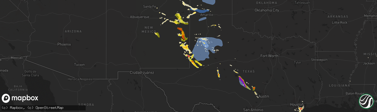
Wind
Hail
71,689
Estimated number of impacted properties by a 1.00" hail or larger20,298
Estimated number of impacted properties by a 1.75" hail or larger10,164
Estimated number of impacted properties by a 2.50" hail or largerStates Impacted by Hail Map on May 31, 2024
Storm reports
New Mexico
| Date | Description |
|---|---|
| 05/31/20246:50 PM CDT | Spotter reported lots of penny to quarter size hail. |
| 05/30/202411:08 PM CDT | Hail up to the size of tennis balls was called in by retired spotter/emergency manager david hooten for the city of hobbs near taos... Copper... And grimes streets. |
| 05/30/202410:49 PM CDT | 1.75 inch diameter hail reported at 9:49 pm mdt north of hobbs. |
| 05/30/202410:45 PM CDT | Report of golf ball size hail off princess jeanne heading south. |
| 05/30/202410:42 PM CDT | Report of golf ball size hail at bender boulevard and e michigan drive near sanger elementary school. |
| 05/30/202410:37 PM CDT | Hail up to 1 in. In diameter reported at corner of taos and grimes streets. |
| 05/30/20249:52 PM CDT | A local report indicates 1.75 inch wind near 1 NNE Hobbs |
| 05/30/20249:51 PM CDT | A local report indicates 1.50 inch wind near 5 N Hobbs |
| 05/30/20249:47 PM CDT | Pea size hail increasing to quarter size hail observed at time of call. |
| 05/30/20249:43 PM CDT | A local report indicates 59 MPH wind near 2 SW Tatum |
| 05/30/20249:39 PM CDT | Lea county em reported downed powerlines and broken skylights from severe winds and hail in tatum. Time is estimated from radar. |
| 05/30/20249:27 PM CDT | Media relayed a photo of a wind turbine north of tatum on fire. This is likely the result of severe wind gusts. Time is estimated from radar. |
| 05/30/20248:05 PM CDT | Roosevelt county emergency manager reported down utility poles at s cr 33 and s cr p. |
| 05/30/20247:12 PM CDT | Elida fire department reported golf ball size hail. |
Florida
| Date | Description |
|---|---|
| 05/31/20246:30 PM CDT | Local broadcast media reported marco island residents received damage from strong winds. Report and pictures of flag poles snapped and laying on the ground in two yards |
| 05/31/20244:50 PM CDT | Corrects previous tstm wnd gst report from 1 se marco island. Lamplighter ct weatherflow station reported a 59 mph wind gust on marco island at 550 pm related to a seve |
| 05/31/20244:25 PM CDT | Rockport ct weatherflow station reported a 67 mph wind gust on marco island at 525 pm related to a severe thunderstorm in the area. |
| 05/31/202412:55 AM CDT | Measured by awos station kegi duke field eglin afb. |
Alabama
| Date | Description |
|---|---|
| 05/31/20243:24 AM CDT | Measured by a personal weather station in downtown fairhope. |
Mississippi
| Date | Description |
|---|---|
| 05/31/20246:10 AM CDT | The center of a medium sized maple tree was snapped... And other small to medium sized branches were blown down in the area. |
Kansas
| Date | Description |
|---|---|
| 05/31/202412:21 AM CDT | Awos station k3k3 syracuse. |
| 05/30/20248:30 PM CDT | Nickle and quarter size hail. Wind gusts of 40 to 50 mph. |
| 05/30/20247:22 PM CDT | A local report indicates 1.00 inch wind near 5 NNW Bloom |
Colorado
| Date | Description |
|---|---|
| 05/31/20246:45 PM CDT | A local report indicates 1.00 inch wind near Byers |
| 05/30/202410:35 PM CDT | A local report indicates 1.00 inch wind near 3 NW Karval |
| 05/30/20248:13 PM CDT | A local report indicates 1.25 inch wind near 1 SSE Security |
| 05/30/20248:10 PM CDT | Report from mping: quarter |
| 05/30/20248:04 PM CDT | A local report indicates 1.25 inch wind near 7 SW Limon |
| 05/30/20248:01 PM CDT | A local report indicates 2.25 inch wind near 9 S Limon |
| 05/30/20247:54 PM CDT | Corrects previous hail report from 9 s limon. |
| 05/30/20247:50 PM CDT | Report from mping: half dollar |
| 05/30/20247:23 PM CDT | A local report indicates 1.75 inch wind near 4 SE Cedar Point |
| 05/30/20247:21 PM CDT | A local report indicates 1.50 inch wind near 6 WSW Limon |
| 05/30/20247:18 PM CDT | A local report indicates 2.00 inch wind near 2 SW Limon |
Iowa
| Date | Description |
|---|---|
| 05/31/20244:16 PM CDT | Multiple rvs flipped and roof ripped off a machine shed. |
| 05/31/20244:16 PM CDT | Corrects previous tstm wnd dmg report from 1 ene sheldon. Multiple rvs flipped and roof ripped off a machine shed. Upon further investigation... Damage was caused by a |
| 05/31/202412:50 PM CDT | [landspout] multiple reports... Including pictures... Of a landspout near the fonda and varina areas. |
Oklahoma
| Date | Description |
|---|---|
| 05/31/20246:55 PM CDT | A local report indicates 59 MPH wind near 1 S Black Mesa Park |
Texas
| Date | Description |
|---|---|
| 05/31/20246:24 PM CDT | A local report indicates 63 MPH wind near 1 NNE Brady |
| 05/31/20246:05 PM CDT | Report from mping: 1-inch tree limbs broken; shingles blown off. |
| 05/31/20245:58 PM CDT | Numerous windows broken by strong winds and hail. |
| 05/31/20245:57 PM CDT | Baseball size hail in vocal. |
| 05/31/20245:50 PM CDT | Report from mping: quarter |
| 05/31/20245:50 PM CDT | Baseball size hail... Power lines broken... And large oak trees down reported in southeast of voca... Tx. |
| 05/31/20245:48 PM CDT | Trained spotter reported in 65 to 70 mph wind gusts that were fairly steady on cr216 just south of cr218. |
| 05/31/20245:48 PM CDT | Trained spotter reported in 65 to 70 mph wind gusts that wer |
| 05/31/20245:44 PM CDT | Report from mping: ping pong ball |
| 05/31/20245:42 PM CDT | Trained spotter reported in golf ball size hail that was getting larger... Possibly up to tennis ball... Started breaking windows on house. |
| 05/31/20245:42 PM CDT | Trained spotter reported in 60 to 70 mph wind gusts southeast of voca... Tx. With golf ball to tennis ball size hail that started breaking her windows while on the phon |
| 05/31/20245:35 PM CDT | A local report indicates 63 MPH wind near 3 NNE Brady |
| 05/31/20245:32 PM CDT | Report from mping: 1-inch tree limbs broken; shingles blown off. |
| 05/31/20245:30 PM CDT | Report from mping: 1-inch tree limbs broken; shingles blown off. |
| 05/31/20245:15 PM CDT | Placid fd official reported in a tornado on ground 4 miles n of fm1121 between hwy 283 and cr 300. |
| 05/31/20245:15 PM CDT | Brief tornado touched down at the cross section of hwy 283 & cr312 at 5:15pm... Reported in by trained storm spotter. |
| 05/31/20245:12 PM CDT | Lohn isd school roof got blown off by wind and is in the middle of the street just east of fm2635. |
| 05/31/20248:50 AM CDT | Small amount of quarter size hail; time estimated via radar. |
| 05/31/20247:55 AM CDT | Palacios asos station measured a 72 mph wind gust. |
| 05/31/20247:53 AM CDT | Palacios asos station measured a 66 mph wind gust. |
| 05/31/20247:30 AM CDT | Corrects previous tstm wnd dmg report time in blessing from 7am to 730am. Local law enforcement reports many trees... Branches... And power lines have fallen in the ble |
| 05/31/20247:30 AM CDT | Time correct from 7am to 730am local law enforcement report numerous trees and powerlines down around elmaton as well as damage to a former school building. |
| 05/31/20247:30 AM CDT | Corrects the reported time from 7am to 730am. Multiple reports of golf ball size hail and possible hail related damage in the blessing area. The golf ball size estimate |
| 05/31/20247:15 AM CDT | Local law enforcement report numerous trees and powerlines down around elmaton as well as damage to a former school building. |
| 05/31/20247:10 AM CDT | Nws forecasters collected numerous hailstones around the forecast office. The largest piece of hail was measured at 2.75 inches. |
| 05/31/20247:00 AM CDT | Local law enforcement reports many trees... Branches... And power lines have fallen in the blessing area. |
| 05/31/20247:00 AM CDT | Doolan drive weatherflow site measured a 59 mph wind gust. |
| 05/31/20247:00 AM CDT | Multiple reports of golf ball size hail and possible hail related damage in the blessing area. The golf ball size estimate came from pictures submitted by the public. |
| 05/31/20242:07 AM CDT | West texas mesonet. |
| 05/31/202412:42 AM CDT | Mesonet station 84 2wnw tarzan tarzan/martin county. |
| 05/31/202412:18 AM CDT | Mesonet station 26 gail 2se. |
| 05/31/202412:02 AM CDT | A local report indicates 59 MPH wind near 6 NW White River Lake |
| 05/30/202411:50 PM CDT | A local report indicates 61 MPH wind near 5 SSW Graham |
| 05/30/202411:45 PM CDT | Mesonet station 96 welch dawson county. |
| 05/30/202411:41 PM CDT | Photo shows carport destroyed. Time is estimated from radar. |
| 05/30/202411:39 PM CDT | A local report indicates 70 MPH wind near 1 N O'Donnell |
| 05/30/202411:37 PM CDT | Seminole fd reports business signs blown down north of seminole along highway 385. Time is estimated from radar. |
| 05/30/202411:11 PM CDT | A local report indicates 64 MPH wind near 2 S Brownfield |
| 05/30/202411:05 PM CDT | Structural damage to home... Garage and trees. Time estimated. |
| 05/30/202411:04 PM CDT | A local report indicates 59 MPH wind near 2 S Brownfield |
| 05/30/202411:02 PM CDT | A local report indicates 66 MPH wind near 3 NNE Tahoka |
| 05/30/202410:55 PM CDT | A local report indicates 60 MPH wind near 1 WNW Denver City |
| 05/30/202410:51 PM CDT | Carport blown into the road. |
| 05/30/202410:47 PM CDT | A local report indicates 64 MPH wind near 4 SE Lubbock |
| 05/30/202410:45 PM CDT | A local report indicates 62 MPH wind near 4 E Lubbock |
| 05/30/202410:36 PM CDT | Report from mping: 1-inch tree limbs broken; shingles blown off. |
| 05/30/202410:30 PM CDT | Photo via social media. |
| 05/30/202410:28 PM CDT | A local report indicates 63 MPH wind near 6 E New Deal |
| 05/30/202410:27 PM CDT | Mesonet station 29 sundown 8sw. |
| 05/30/202410:26 PM CDT | Updated max wind gust from the lubbock asos. |
| 05/30/202410:20 PM CDT | 8 inch diameter tree snapped at the base. |
| 05/30/202410:19 PM CDT | Mesonet station 47 wolfforth 6 mi sw. |
| 05/30/202410:10 PM CDT | Asos station klbb lubbock. |
| 05/30/202410:08 PM CDT | West texas mesonet. Continuous severe gusts observed from 10:05 pm to 10:09 pm. |
| 05/30/202410:02 PM CDT | West texas mesonet. |
| 05/30/202410:01 PM CDT | West texas mesonet. Continuous severe gusts observed from 9:53 pm to 10:03 pm. |
| 05/30/20249:52 PM CDT | West texas mesonet. |
| 05/30/20249:42 PM CDT | A local report indicates 63 MPH wind near 3 NNE Umbarger |
| 05/30/20249:39 PM CDT | West texas mesonet. |
| 05/30/20249:35 PM CDT | Sustained wind of 70 mph also recorded. Measured by the west texas mesonet. |
| 05/30/20249:28 PM CDT | Measured gust of 76 mph on vehicle-mounted weather station. |
| 05/30/20249:05 PM CDT | A local report indicates 62 MPH wind near 9 NNE Sunray |
| 05/30/20248:36 PM CDT | A local report indicates 61 MPH wind near 11 S Romero |
Nebraska
| Date | Description |
|---|---|
| 05/31/20243:50 AM CDT | Golf ball hail. Time from radar. |
| 05/31/20243:40 AM CDT | Hail to ping pong ball size. Time from radar. |
Cities Impacted by Hail Map on May 31, 2024
- Louise, TX
- El Campo, TX
- Harper, TX
- Kerrville, TX
- Ingram, TX
- Mountain Home, TX
- Tuscola, TX
- Ganado, TX
- Fredericksburg, TX
- Midfield, TX
- Millersview, TX
- Voss, TX
- Doole, TX
- Bay City, TX
- Markham, TX
- Blessing, TX
- Wingate, TX
- Comfort, TX
- Rosharon, TX
- Manvel, TX
- Palacios, TX
- Dickinson, TX
- Liverpool, TX
- Santa Fe, TX
- Alvin, TX
- Crosby, TX
- Baytown, TX
- Ovalo, TX
- Dayton, TX
- Hitchcock, TX
- Boerne, TX
- New Braunfels, TX
- Center Point, TX
- Seguin, TX
- Kingsbury, TX
- Port O'Connor, TX
- Lolita, TX
- Matagorda, TX
- Elmaton, TX
- Kendalia, TX
- Spring Branch, TX
- Bergheim, TX
- Abilene, TX
- Bishop, TX
- Kingsville, TX
- League City, TX
- Kemah, TX
- Las Vegas, NM
- Bacliff, TX
- Houston, TX
- Webster, TX
- Friendswood, TX
- La Marque, TX
- Texas City, TX
- Seabrook, TX
- Pearland, TX
- Woodville, MS
- Boca Grande, FL
- Coleman, TX
- Gouldbusk, TX
- Lohn, TX
- Talpa, TX
- Rockwood, TX
- Corona, NM
- Folsom, NM
- Ballinger, TX
- Marco Island, FL
- San Saba, TX
- Melrose, NM
- Minneola, KS
- Brady, TX
- Rochelle, TX
- Anton Chico, NM
- Des Moines, NM
- Madison, MS
- Santa Rosa, NM
- Vaughn, NM
- Richland Springs, TX
- Beloit, KS
- Cherokee, TX
- Pritchett, CO
- Barnard, KS
- Strasburg, CO
- Bennett, CO
- Duke, OK
- Seymour, TX
- Crowell, TX
- Shattuck, OK
- Sayre, OK
- Rosston, OK
- Voca, TX
- Floyd, NM
- Fredonia, TX
- Byers, CO
- Mason, TX
- Pontotoc, TX
- Melvin, TX
- Portales, NM
- Deer Trail, CO
- Llano, TX
- Tow, TX
- Conchas Dam, NM
- Sylvan Grove, KS
- Dodge City, KS
- Agate, CO
- Cuervo, NM
- Sterling City, TX
- Bluffton, TX
- Tucumcari, NM
- Valley Spring, TX
- Art, TX
- Buchanan Dam, TX
- Castell, TX
- House, NM
- Burnet, TX
- Elida, NM
- Limon, CO
- Matheson, CO
- Loraine, TX
- Fort Sumner, NM
- Clayton, NM
- Roy, NM
- Kingsland, TX
- Mcalister, NM
- Hunter, KS
- Salina, KS
- Lindsborg, KS
- Marble Falls, TX
- Elbert, CO
- Calhan, CO
- Assaria, KS
- Marquette, KS
- Falun, KS
- Mosquero, NM
- Pep, NM
- Grady, NM
- Hugo, CO
- Colorado Springs, CO
- Bard, NM
- San Jon, NM
- Ramah, CO
- Larkspur, CO
- Gypsum, KS
- Galva, KS
- Simla, CO
- Castle Rock, CO
- Clovis, NM
- Mcpherson, KS
- Nara Visa, NM
- Amistad, NM
- Adrian, TX
- Causey, NM
- Franktown, CO
- Fountain, CO
- Milnesand, NM
- Vona, CO
- Round Mountain, TX
- Johnson City, TX
- Newton, KS
- Moundridge, KS
- Horseshoe Bay, TX
- Inman, KS
- Tatum, NM
- Mertzon, TX
- Crossroads, NM
- Peyton, CO
- Channing, TX
- Hesston, KS
- Halstead, KS
- Sudan, TX
- Vega, TX
- Logan, NM
- Amherst, TX
- Dripping Springs, TX
- Stratton, CO
- Buhler, KS
- Karval, CO
- Stratford, TX
- Rogers, NM
- North Newton, KS
- Littlefield, TX
- Boone, CO
- Hutchinson, KS
- Burrton, KS
- Gruver, TX
- Sedgwick, KS
- Pep, TX
- Dumas, TX
- Cactus, TX
- Sunray, TX
- Morse, TX
- Spearman, TX
- Amarillo, TX
- Goodwell, OK
- Stinnett, TX
- Borger, TX
- Levelland, TX
- Anton, TX
- Shallowater, TX
- Lubbock, TX
- Haven, KS
- Lovington, NM
- Abernathy, TX
- Smyer, TX
- Wolfforth, TX
- Ropesville, TX
- Sundown, TX
- Meadow, TX
- New Deal, TX
- Hereford, TX
- Canyon, TX
- Idalou, TX
- Lorenzo, TX
- Tahoka, TX
- Brownfield, TX
- Olney Springs, CO
- Kit Carson, CO
- Wilson, TX
- Slaton, TX
- Ordway, CO
- Crowley, CO
- Manzanola, CO
- Ransom Canyon, TX
- Plains, TX
- Tokio, TX
- Post, TX
- Ralls, TX
- Mcdonald, NM
- Hobbs, NM
- Petersburg, TX
- Crosbyton, TX
- Denver City, TX
- Tulia, TX
- Andrews, TX
- Panhandle, TX
- Seminole, TX
- Silverton, TX
- Masterson, TX
- Odonnell, TX
- Seagraves, TX
- Loop, TX
- Clarendon, TX
- Lamesa, TX
- Welch, TX
- Ackerly, TX
- Gail, TX
- Fluvanna, TX
- Justiceburg, TX
- Spur, TX
- Dickens, TX
- Mcadoo, TX
- Snyder, TX
- Paducah, TX
- Girard, TX
- Turkey, TX
- Afton, TX
- Floydada, TX
- Leoti, KS
- Matador, TX
- Marienthal, KS
- Tarzan, TX
- Lenorah, TX
- Scott City, KS
- Capitan, NM
- Stanton, TX
- Goldsmith, TX
- Colorado City, TX
- Healy, KS
- Dighton, KS
- Hemingford, NE
- Waynesboro, MS
- Gardendale, TX
- Utica, KS
- Beeler, KS
- Alliance, NE
- Ellsworth, NE
- Oshkosh, NE
- Chadron, NE
- Ransom, KS
- Ness City, KS
- Lakeside, NE
- Bazine, KS
- Ashby, NE
- Harrison, NE
- Fairhope, AL
- Daphne, AL
- Silverhill, AL
- Loxley, AL
- Lewellen, NE
- Bingham, NE
- Bridgeport, NE
- Alexander, KS
- Canton, MS
- Arthur, NE
- Hay Springs, NE
- Broadview, NM
- Sutherland, NE
- Rushville, NE
- Hershey, NE
- Carthage, MS
- North Platte, NE