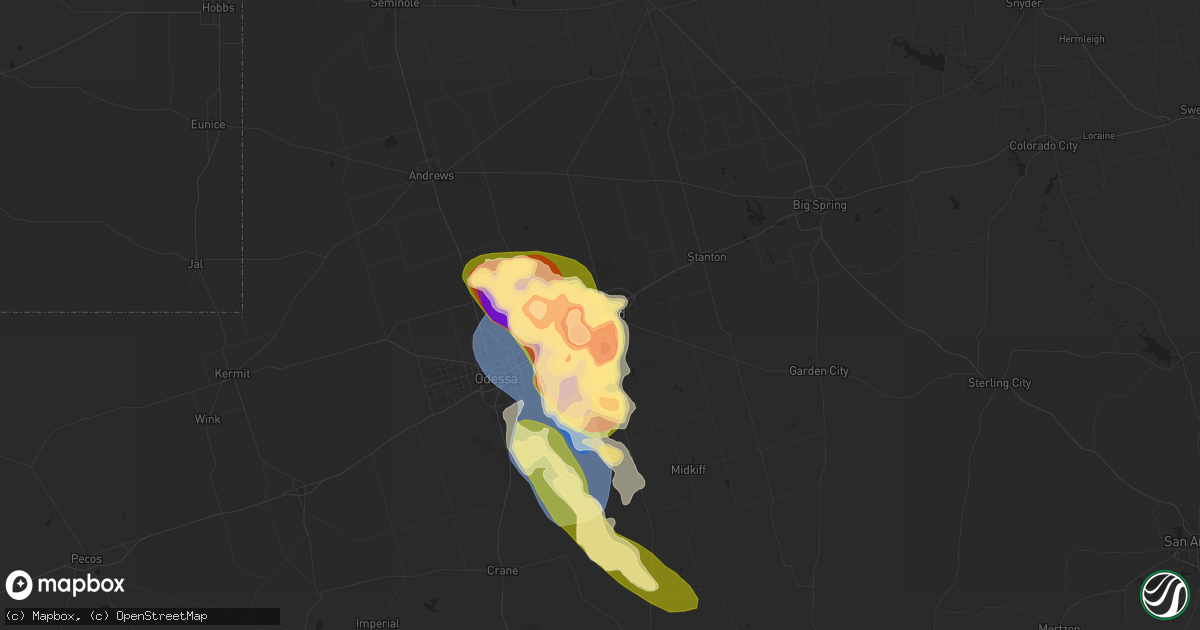
Hail Map in Midland, TX on May 30, 2024
Get this storm
May 30 map
$229
one time, instant access
Download today. No call, no setup
Keep the $229
Bought the map and want the full workflow? Apply the entire $229 to a subscription within 7 days. None of it is wasted.
Every map, not just this one
This buys you this map. Subscription and you get every map we run, in the markets you choose from a few cities to whole states to nationwide. Plus real-time alerts the moment a storm fires.
Contact data
Name, contact info, occupancy, even credit band for addresses in the footprint. You go from where it hit to who to call.
Become the source they trust
Unlimited branding weather history reports on demand. You already have the documented answer ready for the property owner, and you are the one who showed up with it.
Property data and RoofTrace estimates
Pull up any address you have got, its value and the exact code rules for that jurisdiction, straight from One Click Code. Then RoofTrace estimates the squares, pitch, and roof value, priced the way you price.
Storm reports in Midland, TX
Midland, TX
| Date | Description |
|---|---|
| 05/30/20246:15 PM CDT | A local report indicates 1.75 inch wind near 13 NW Midkiff |
| 05/30/20246:04 PM CDT | Report from mping: 3-inch tree limbs broken; power poles broken. |
| 05/30/20246:03 PM CDT | Mesonet station mndt2 midland. |
| 05/30/20245:41 PM CDT | Multiple reports and photos showing baseball to softball size hail south of midland. Time is estiamted from radar. |
| 05/30/20245:21 PM CDT | Nws employee reports golf ball size hail and possible roof damage. Time estimated from radar. |
| 05/30/20245:17 PM CDT | Report from mping: tea cup |
| 05/30/20245:17 PM CDT | View from nws midland of tornado south of the airport on i-20. |
| 05/30/20245:16 PM CDT | Over 20 power poles snapped along fm 1788 west of midland international airport. Time estimated from radar. |
| 05/30/20245:16 PM CDT | Hail caused damage to vehicle... Breaking window. Estimated a few baseball size hailstones. Time estimated from radar. |
| 05/30/20245:16 PM CDT | Report of damage to dk gas station canopy at midland dr and andrews highway. Time is estimated from radar. |
| 05/30/20245:15 PM CDT | Large hail began at approximately 515 pm cdt at nws midland and lasted between 45 minutes and an hour. Hail reached upwards of tennis ball to baseball size. This hail b |
| 05/30/20245:10 PM CDT | 2 inch diameter hail at midland park mall on north loop 250. |
| 05/30/20245:10 PM CDT | 2 inch diameter hail at midland |
| 05/30/20244:45 PM CDT | A local report indicates 1.00 inch wind near 6 E Gardendale |
All States Impacted by Hail Map on May 30, 2024
All Cities Impacted by Hail Map on May 30, 2024
- Melrose, NM
- Clovis, NM
- Weinert, TX
- Olney, TX
- Haskell, TX
- Holliday, TX
- Pampa, TX
- Clarendon, TX
- Lelia Lake, TX
- Hedley, TX
- Wichita Falls, TX
- Silverton, TX
- Paducah, TX
- Henrietta, TX
- Throckmorton, TX
- Seymour, TX
- Bogue Chitto, MS
- Saint Paul, NE
- Dannebrog, NE
- Munday, TX
- Mclean, TX
- Childress, TX
- Memphis, TX
- Jacksboro, TX
- Bowie, TX
- Bellevue, TX
- Matador, TX
- Tell, TX
- Quanah, TX
- Cee Vee, TX
- Magnolia, MS
- Crowell, TX
- Mccomb, MS
- Tylertown, MS
- Gainesville, TX
- Muenster, TX
- Lindsay, TX
- Valley View, TX
- Loving, TX
- Windthorst, TX
- Medford, OK
- Caldwell, KS
- Westwego, LA
- Sandy Hook, MS
- Angie, LA
- South Haven, KS
- Franklinton, LA
- Kentwood, LA
- Amite, LA
- Archer City, TX
- Dallas, TX
- Carrollton, TX
- Lewisville, TX
- Deer Creek, OK
- Braman, OK
- Nardin, OK
- Carriere, MS
- Ponchatoula, LA
- Atoka, OK
- Covington, LA
- Picayune, MS
- Folsom, LA
- Madisonville, LA
- Mandeville, LA
- Slidell, LA
- Duncanville, TX
- Breckenridge, TX
- Blackwell, TX
- Miami, FL
- Era, TX
- Eastland, TX
- Granbury, TX
- Ranger, TX
- Cedar Hill, TX
- The Colony, TX
- Grenville, NM
- Kenton, OK
- Saltillo, TX
- Mount Vernon, TX
- Clinton, LA
- Nolan, TX
- Rattan, OK
- Desdemona, TX
- Cross Plains, TX
- Cisco, TX
- Lancaster, TX
- Hutchins, TX
- Valliant, OK
- Dublin, TX
- Stephenville, TX
- Rising Star, TX
- Talco, TX
- Midlothian, TX
- Tolar, TX
- Glen Rose, TX
- Bogata, TX
- Pleasant Dale, NE
- Clayton, NM
- Rainbow, TX
- Nemo, TX
- Waxahachie, TX
- Italy, TX
- Milford, TX
- Kopperl, TX
- Cleburne, TX
- Red Oak, TX
- Meridian, TX
- Rio Vista, TX
- Hico, TX
- Blum, TX
- Bluff Dale, TX
- Covington, TX
- Foreman, AR
- Venus, TX
- Maypearl, TX
- Hallsville, TX
- Colorado Springs, CO
- Walnut Springs, TX
- Morgan, TX
- Haworth, OK
- Iredell, TX
- Grand Prairie, TX
- Clifton, TX
- Grandview, TX
- Hillsboro, TX
- Boise City, OK
- Marshall, TX
- Valley Mills, TX
- Ennis, TX
- Itasca, TX
- Whitney, TX
- Umpire, AR
- Brewster, NE
- Ferris, TX
- Dalhart, TX
- Bynum, TX
- Liberty, MS
- Larkspur, CO
- Mertens, TX
- Jonesboro, TX
- Cranfills Gap, TX
- Abbott, TX
- Hawkins, TX
- Lindale, TX
- Gatesville, TX
- Fort Stockton, TX
- Malone, TX
- Penelope, TX
- Centreville, MS
- West, TX
- Hubbard, TX
- Frost, TX
- Fountain, CO
- Pueblo, CO
- Elm Mott, TX
- Waco, TX
- Blooming Grove, TX
- Milnesand, NM
- Groesbeck, TX
- Kemp, TX
- Morton, TX
- Bassett, NE
- Crawford, TX
- Oglesby, TX
- Dawson, TX
- Andrews, TX
- Prairie Hill, TX
- Tyler, TX
- Ochopee, FL
- Athens, TX
- Woodway, TX
- Coolidge, TX
- Mart, TX
- Gladewater, TX
- Gardendale, TX
- Purdon, TX
- Mexia, TX
- Wortham, TX
- Gloster, MS
- Crosby, MS
- Chilton, TX
- Lorena, TX
- Immokalee, FL
- Brownsboro, TX
- Chandler, TX
- Ben Wheeler, TX
- Big Sandy, TX
- McGregor, TX
- Hewitt, TX
- Midland, TX
- Odessa, TX
- Waskom, TX
- Troup, TX
- North Fort Myers, FL
- Cape Coral, FL
- Kilgore, TX
- Fairfield, TX
- Overton, TX
- Melvin, TX
- Riesel, TX
- Marlin, TX
- Georgetown, TX
- Plains, TX
- Karnack, TX
- Marquez, TX
- Denver City, TX
- Lott, TX
- Rosebud, TX
- Reagan, TX
- Garden City, TX
- Longview, TX
- Henderson, TX
- Clewiston, FL
- Belton, TX
- Temple, TX
- Dryden, TX
- Stanton, TX
- Mitchell, SD
- Pflugerville, TX
- Thornton, TX
- Elkhart, TX
- Tennessee Colony, TX
- Cameron, TX
- Bremond, TX
- Kosse, TX
- Stratford, TX
- Gruver, TX
- Spearman, TX
- Sunray, TX
- Stinnett, TX
- Cactus, TX
- Channing, TX
- Dumas, TX
- Morse, TX
- Hartley, TX
- Tatum, TX
- Hutto, TX
- Taylor, NE
- Mosquero, NM
- Calvert, TX
- Fort Myers, FL
- Manor, TX
- Taylor, TX
- Coupland, TX
- Milano, TX
- Caldwell, TX
- Franklin, TX
- Madisonville, TX
- Boone, CO
- Gause, TX
- Olney Springs, CO
- Navasota, TX
- Anderson, TX
- Granger, TX
- Causey, NM
- Anselmo, NE
- Grapeland, TX
- Fowler, CO
- Normangee, TX
- Beckville, TX
- Troy, TX
- Seagraves, TX
- Seminole, TX
- Whiteface, TX
- Masterson, TX
- Borger, TX
- Amarillo, TX
- Fritch, TX
- Nara Visa, NM
- Amistad, NM
- Vega, TX
- Leona, TX
- Midway, TX
- Pep, NM
- Tyrone, OK
- Huntington, TX
- Ordway, CO
- Kennard, TX
- Hearne, TX
- Goodwell, OK
- Guymon, OK
- Texhoma, TX
- Texhoma, OK
- Hardesty, OK
- Moody, TX
- Bryan, TX
- Manzanola, CO
- Centerville, TX
- Crockett, TX
- Broken Bow, NE
- Diboll, TX
- Hugoton, KS
- Lufkin, TX
- Pollok, TX
- Montgomery, TX
- San Augustine, TX
- Bronson, TX
- North Zulch, TX
- Richards, TX
- Karval, CO
- Sugar City, CO
- Lovelady, TX
- Breaux Bridge, LA
- Lafitte, LA
- Church Point, LA
- Kinder, LA
- Braithwaite, LA
- Napoleonville, LA
- Plaquemine, LA
- Thibodaux, LA
- Bokeelia, FL
- Basile, LA
- Des Allemands, LA
- Carencro, LA
- Boca Grande, FL
- Barataria, LA
- Plattenville, LA
- Sunset, LA
- Belle Rose, LA
- Eunice, LA
- Liberal, KS
- Groveton, TX
- Pennington, TX
- Apple Springs, TX
- Rocky Ford, CO
- Chireno, TX
- Tatum, NM
- Bedias, TX
- Carthage, TX
- Arlington, CO
- Logan, NM
- Loop, TX
- McCamey, TX
- Crane, TX
- Midkiff, TX
- San Jon, NM
- Perryton, TX
- Balko, OK
- Miami, TX
- Canyon, TX
- Panhandle, TX
- Skellytown, TX
- White Deer, TX
- Merna, NE
- Clinton, MN
- Kismet, KS
- Turpin, OK
- Elgin, TX
- Iola, TX
- Corrigan, TX
- Nacogdoches, TX
- Somerville, TX
- Broaddus, TX
- Wilmot, SD
- Ortonville, MN
- Beardsley, MN
- Seibert, CO
- Forgan, OK
- Huntsville, TX
- College Station, TX
- Ethan, SD
- Parkston, SD
- Emery, SD
- Rye, CO
- Center, TX
- Walsenburg, CO
- De Berry, TX
- Thorndale, TX
- Alexandria, SD
- La Junta, CO
- Vona, CO
- Stratton, CO
- Scotland, SD
- Joaquin, TX
- Shelbyville, TX
- Thrall, TX
- Oakhurst, TX
- Zavalla, TX
- Hereford, TX
- Wiergate, TX
- Lexington, TX
- McDade, TX
- Muleshoe, TX
- Freeman, SD
- Bridgewater, SD
- Plantersville, TX
- Logansport, LA
- Mansfield, LA
- Grand Cane, LA
- Bethune, CO
- Las Animas, CO
- Tuscola, TX
- Wingate, TX
- Coldspring, TX
- Ansley, NE
- Junction, TX
- Merkel, TX
- Abilene, TX
- Groom, TX
- Claude, TX
- Canadian, TX
- Burlington, CO
- McClave, CO
- Hasty, CO
- Tabor, SD
- Lesterville, SD
- Winters, TX
- Ovalo, TX
- Hemphill, TX
- Buffalo Gap, TX
- Bloomfield, NE
- Magnolia, TX
- Iraan, TX
- Brownfield, TX
- Goldsboro, TX
- Novice, TX
- Lawn, TX
- Wayside, TX
- Utica, SD
- Talpa, TX
- Yankton, SD
- Clyde, TX
- Coleman, TX
- Marion, SD
- Kirk, CO
- Burkeville, TX
- Leesville, LA
- Evans, LA
- Anacoco, LA
- Clearwater, NE
- Oconto, NE
- Conroe, TX
- Milam, TX
- Pineland, TX
- Zwolle, LA
- Many, LA
- Florien, LA
- Fisher, LA
- Hornbeck, LA
- Provencal, LA
- New Llano, LA
- Robeline, LA
- Quail, TX
- Tahoka, TX
- Lamesa, TX
- Plainview, NE
- Eads, CO
- Cozad, NE
- Lexington, NE
- Pinehurst, TX
- Justiceburg, TX
- Baird, TX
- Briscoe, TX
- Pitkin, LA
- Fort Polk, LA
- Slagle, LA
- Burkett, TX
- Elgin, NE
- Wellington, TX
- Shamrock, TX
- Post, TX
- Frierson, LA
- Reydon, OK
- Sweetwater, OK
- Longville, LA
- Welch, TX
- Mora, LA
- Cloutierville, LA
- Natchez, LA
- Simpson, LA
- Natchitoches, LA
- Melrose, LA
- Flatwoods, LA
- Lena, LA
- Hineston, LA
- Idalia, CO
- Holly, CO
- Cheyenne, OK
- Mission Hill, SD
- Volin, SD
- Deridder, LA
- Sumner, NE
- Miller, NE
- Santa Anna, TX
- Carbon, TX
- Gorman, TX
- Sidney, TX
- Brownwood, TX
- Bangs, TX
- May, TX
- Comanche, TX
- De Leon, TX
- Early, TX
- Sieper, LA
- Montgomery, LA
- Boyce, LA
- New Waverly, TX
- Elmer, LA
- Oakdale, LA
- Otis, LA
- Glenmora, LA
- Colfax, LA
- Elizabeth, LA
- Willis, TX
- Cleveland, TX
- Dayton, TX
- Liberty, TX
- Splendora, TX
- Baytown, TX
- Waller, TX
- Snook, TX
- Huffman, TX
- Hockley, TX
- Crosby, TX
- Washington, TX
- New Caney, TX
- Tomball, TX
- Brenham, TX
- Spring, TX
- Kingwood, TX
- Porter, TX
- Houston, TX
- Highlands, TX
- Channelview, TX
- Humble, TX
- Hempstead, TX
- Odonnell, TX
- Gail, TX
- Tribune, KS
- Sheridan Lake, CO
- Longmont, CO
- Boulder, CO
- Sayre, OK
- Erick, OK
- Saint Francis, KS
- Ewing, NE
- Devers, TX
- Hull, TX
- Wallisville, TX
- Anahuac, TX
- Hankamer, TX
- Atlanta, LA
- Dry Prong, LA
- Pineville, LA
- Alexandria, LA
- Woodworth, LA
- Bentley, LA
- Forest Hill, LA
- Georgetown, LA
- Ville Platte, LA
- Pollock, LA
- Lecompte, LA
- Cheneyville, LA
- Saint Landry, LA
- Bunkie, LA
- Ball, LA
- Hessmer, LA
- Marksville, LA
- Deville, LA
- Blanket, TX
- Gustine, TX
- Zephyr, TX
- Wray, CO
- Osmond, NE
- Fort Lupton, CO
- Hudson, CO
- Santo, TX
- Lipan, TX
- Syracuse, KS
- Niwot, CO
- Lafayette, CO
- Erie, CO
- O'Brien, TX
- Rochester, TX
- Wiggins, CO
- Roggen, CO
- Mingus, TX
- Brighton, CO
- Rule, TX
- Dacono, CO
- Big Spring, TX
- Knott, TX
- Eldorado, OK
- Gould, OK
- Leoti, KS
- Keenesburg, CO
- Carlton, TX
- Priddy, TX
- Hamilton, TX
- Mullin, TX
- Pottsville, TX
- Coahoma, TX
- Alvarado, TX
- Mansfield, TX
- Burleson, TX
- Lillian, TX
- Broomfield, CO
- Opelousas, LA
- Duke, OK
- Commerce City, CO
- Denver, CO
- Thornton, CO
- Westminster, CO
- Winona, KS
- Sweetwater, TX
- Chillicothe, TX
- Arlington, TX
- Moorefield, NE
- Sharon Springs, KS
- Palmer, TX
- Roscoe, TX
- Fort Worth, TX
- Henderson, CO
- Dupont, CO
- Mansura, LA
- Cottonport, LA
- Effie, LA
- Center Point, LA
- Jena, LA
- Evergreen, LA
- Trout, LA
- Evant, TX
- Loraine, TX
- Colorado City, TX
- Westbrook, TX
- Haigler, NE
- Parks, NE
- Olustee, OK
- Odell, TX
- Wallace, KS
- Arnaudville, LA
- Goree, TX
- Goldthwaite, TX
- Bennett, CO
- Trent, TX
- Crowley, TX
- Kennedale, TX
- Aurora, CO
- Stockville, NE
- Watkins, CO
- Benkelman, NE
- Joshua, TX
- Vernon, TX
- Monument, KS
- Edson, KS
- Byers, CO
- Aledo, TX
- Maryneal, TX
- Bird City, KS
- Sterling City, TX
- Perrin, TX
- Bronte, TX
- Irving, TX
- Woodrow, CO
- Aquilla, TX
- China Spring, TX
- Goodland, KS
- Robert Lee, TX
- Newcastle, TX
- Mason City, NE
- Jeanerette, LA
- Electra, TX
- Graham, TX
- Paradise, TX
- Franklin, LA
- Tye, TX
- Deer Trail, CO
- Harrold, TX
- Purmela, TX
- Grinnell, KS
- Baldwin, LA
- Norton, TX
- Brewster, KS
- Iowa Park, TX
- Scotland, TX
- Oakley, KS
- Genoa, CO
- Burkburnett, TX
- Ballinger, TX
- Rowena, TX
- Akron, CO
- Lindon, CO
- Colby, KS
- Bartley, NE
- Indianola, NE
- Callaway, NE
- Wauneta, NE
- Limon, CO
- Sheppard Afb, TX
- Bartlett, NE
- Miles, TX
- Arriba, CO
- Stratton, NE
- Bruceville, TX
- Hayes Center, NE
- Byers, TX
- Eddy, TX
- Petrolia, TX
- Palisade, NE
- Sunset, TX
- Gouldbusk, TX
- Valera, TX
- Paint Rock, TX
- Nocona, TX
- Roosevelt, OK
- Mountain View, OK
- Creighton, NE
- Merino, CO
- Millersview, TX
- San Angelo, TX
- Wall, TX
- Vancourt, TX
- Eola, TX
- Montague, TX
- Saint Jo, TX
- Farnam, NE
- Brunswick, NE
- Pierce, NE
- Neligh, NE
- Oakdale, NE
- Rockwood, TX
- Atwood, CO
- Doole, TX
- Eden, TX
- Brookesmith, TX
- Atwood, KS
- Lohn, TX
- Rochelle, TX
- Christoval, TX
- Flagler, CO
- Grover, CO
- Pine Bluffs, WY
- Bushnell, NE
- Carpenter, WY
- Oberlin, KS
- Brady, TX
- Menard, TX
- Star, TX
- Lometa, TX
- Lampasas, TX
- Copperas Cove, TX
- Axtell, TX
- Norton, KS
- Castell, TX
- Mason, TX
- Art, TX
- Llano, TX
- Stockton, KS
- Woodston, KS
- Pontotoc, TX
- Fredonia, TX
- Round Rock, TX
- Marble Falls, TX
- Salado, TX
- Nolanville, TX
- Fort Hood, TX
- Harker Heights, TX
- Killeen, TX
- Florence, TX
- Jarrell, TX
- Holland, TX
- Bartlett, TX
- Paige, TX
- Maxwell, TX
- Dale, TX
- Briggs, TX
- San Marcos, TX
- Leander, TX
- Kyle, TX
- Liberty Hill, TX
- Buda, TX
- Cedar Park, TX
- Bastrop, TX
- Cedar Creek, TX
- Austin, TX
- Bertram, TX
- Kempner, TX
- Del Valle, TX
- Lockhart, TX
- Manchaca, TX
- Burnet, TX
- Spicewood, TX
- Red Rock, TX
- Waelder, TX
- Smithville, TX
- Muldoon, TX
- Rosanky, TX
- Flatonia, TX
- Voss, TX
- Harper, TX
- Mountain Home, TX
- Santa Fe, TX
- Texas City, TX
- Hitchcock, TX
- Dickinson, TX
- La Marque, TX
- Alvin, TX
- League City, TX
- El Campo, TX
- Louise, TX
- Bacliff, TX
- Kemah, TX
- Richmond, TX
- Rosenberg, TX
- Hemingford, NE
- Alliance, NE


