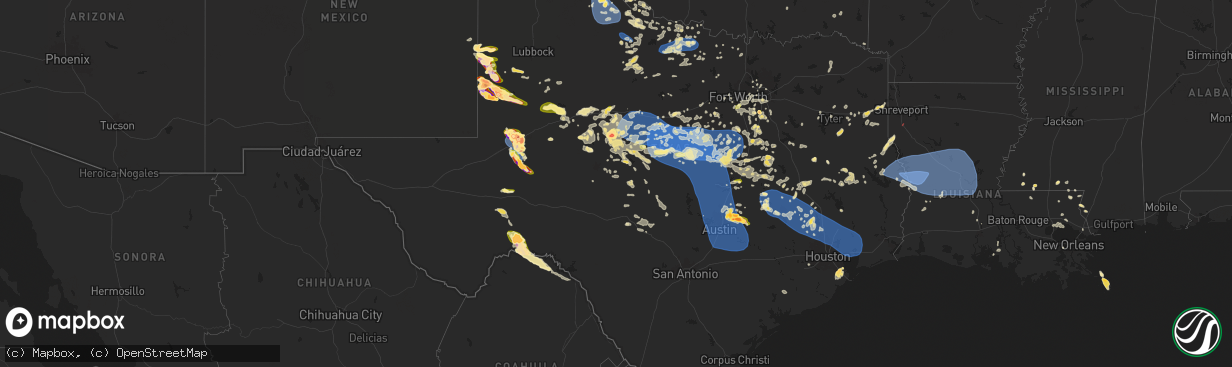
Hail Map in Texas on May 30, 2024
The weather event in Texas on May 30, 2024 includes Wind, Hail, and Tornado maps. 13 states and 806 cities were impacted and suffered possible damage. The total estimated number of properties impacted is 101,512.
Want more than just the map?
Turn this storm into a full workflow.
- Owner + property data so you know who to knock
- OnDemand branded weather history reports to win the "did we even have hail?" argument
- RoofTrace estimate so reps stop guessing numbers at the door
Bought this map? Upgrade within 7 days and we'll credit the $230. (10-15 min setup call)
Wind
Hail
Tornado
101,512
Estimated number of impacted properties by a 1.00" hail or larger54,593
Estimated number of impacted properties by a 1.75" hail or larger50,469
Estimated number of impacted properties by a 2.50" hail or largerStorm reports in Texas
Texas
| Date | Description |
|---|---|
| 05/30/20246:59 PM CDT | An nws storm survey was conducted south/southeast of de berry tx... Finding sporadic wind damage. A few snapped trees and large tree branches were found downed along fm |
| 05/30/20246:57 PM CDT | 3 inch diameter hail on us62. |
| 05/30/20246:49 PM CDT | Report of trees down and limbs broken in huntsville due to strong thunderstorm winds. |
| 05/30/20246:49 PM CDT | Reports of 0.5 inch to 1 inch hail near cr448/fm619. |
| 05/30/20246:48 PM CDT | Measured picture of 2.5 inch hail next to ruler shared on social media. Time estimated by radar. |
| 05/30/20246:48 PM CDT | Picture of large hail stone on social media estimated between 3 and 3.5 inches. Time estimated from radar. |
| 05/30/20246:48 PM CDT | A local report indicates 59 MPH wind near 2 E Pampa |
| 05/30/20246:47 PM CDT | Report from mping: 1-inch tree limbs broken; shingles blown off. |
| 05/30/20246:46 PM CDT | 2 inch diameter hail on us62. |
| 05/30/20246:45 PM CDT | Txdot reported trees down in houston county on multiple roads. Fm2110... Fm1733... Sh 7w... Fm227 w... And fm2544. |
| 05/30/20246:44 PM CDT | Large tornado formed on the upton/midland county line. |
| 05/30/20246:34 PM CDT | Madison county dispatch reports of trees down due to strong thunderstorm winds. |
| 05/30/20246:29 PM CDT | Corrects previous tstm wnd gst report from 7 e borger. |
| 05/30/20246:29 PM CDT | A local report indicates 64 MPH wind near 7 E Borger |
| 05/30/20246:28 PM CDT | Time estimated from radar. |
| 05/30/20246:23 PM CDT | Sporadic coverage along highway 214. |
| 05/30/20246:20 PM CDT | A local report indicates 1.50 inch wind near 8 W Seagraves |
| 05/30/20246:18 PM CDT | Trees down reported by sheriffs office. |
| 05/30/20246:15 PM CDT | A local report indicates 1.75 inch wind near 13 NW Midkiff |
| 05/30/20246:10 PM CDT | A local report indicates 64 MPH wind near 1 NNW Stinnett |
| 05/30/20246:10 PM CDT | Shared via social media. |
| 05/30/20246:07 PM CDT | Report from mping: 3-inch tree limbs broken; power poles broken. |
| 05/30/20246:04 PM CDT | Photo via social media. |
| 05/30/20246:04 PM CDT | Report from mping: 3-inch tree limbs broken; power poles broken. |
| 05/30/20246:03 PM CDT | Mesonet station mndt2 midland. |
| 05/30/20246:01 PM CDT | Photo via social media. |
| 05/30/20245:56 PM CDT | On highway 214. |
| 05/30/20245:55 PM CDT | Measured at klhb. |
| 05/30/20245:53 PM CDT | Asos station kodo odessa. |
| 05/30/20245:49 PM CDT | Falling on highway 214. |
| 05/30/20245:48 PM CDT | Picture of what looks to be golfball sized hail on the east side of hutto shared on social media. Time estimated by radar. |
| 05/30/20245:48 PM CDT | Picture of near hen egg sized hail shared on social media. |
| 05/30/20245:45 PM CDT | Mesonet station fw9685 odessa. |
| 05/30/20245:45 PM CDT | Texas water development board mesonet site at lake striker reported a wind gust of 58 mph. |
| 05/30/20245:41 PM CDT | Multiple reports and photos showing baseball to softball size hail south of midland. Time is estiamted from radar. |
| 05/30/20245:38 PM CDT | Sheriffs office reported trees down. |
| 05/30/20245:36 PM CDT | Social media photo se of troy... Tx with half dollar size hail. |
| 05/30/20245:31 PM CDT | *** 2 inj *** odessa fd/pd responded to a report of an overturned double wide trailer home along cr 172. This was likely the result of intense rfd winds on the backside |
| 05/30/20245:29 PM CDT | Trees down throughout rusk county. Time estimated from radar. |
| 05/30/20245:25 PM CDT | Fire dept shared photos of damaged outbuilding near fm 1788 and cr 127. Damage is likely from rfd winds. |
| 05/30/20245:24 PM CDT | A local report indicates 64 MPH wind near 3 SE Dumas |
| 05/30/20245:21 PM CDT | Nws employee reports golf ball size hail and possible roof damage. Time estimated from radar. |
| 05/30/20245:21 PM CDT | Power lines down along w hwy 80/business 20 at cr1296. Time estimated from radar. |
| 05/30/20245:20 PM CDT | Sheriff office reported trees down in troup. Time estimated from radar. |
| 05/30/20245:17 PM CDT | View from nws midland of tornado south of the airport on i-20. |
| 05/30/20245:17 PM CDT | Report from mping: tea cup |
| 05/30/20245:16 PM CDT | Over 20 power poles snapped along fm 1788 west of midland international airport. Time estimated from radar. |
| 05/30/20245:16 PM CDT | Report of damage to dk gas station canopy at midland dr and andrews highway. Time is estimated from radar. |
| 05/30/20245:16 PM CDT | Hail caused damage to vehicle... Breaking window. Estimated a few baseball size hailstones. Time estimated from radar. |
| 05/30/20245:15 PM CDT | Large hail began at approximately 515 pm cdt at nws midland and lasted between 45 minutes and an hour. Hail reached upwards of tennis ball to baseball size. This hail b |
| 05/30/20245:14 PM CDT | Peak sunray mesonet gust. |
| 05/30/20245:10 PM CDT | 2 inch diameter hail at midland |
| 05/30/20245:10 PM CDT | 2 inch diameter hail at midland park mall on north loop 250. |
| 05/30/20245:04 PM CDT | A local report indicates 58 MPH wind near 9 NNE Sunray |
| 05/30/20245:02 PM CDT | Trees and power lines reported down in the whitehouse area. |
| 05/30/20244:54 PM CDT | Hail ranged from golf ball to baseball sized. |
| 05/30/20244:45 PM CDT | A local report indicates 1.00 inch wind near 6 E Gardendale |
| 05/30/20244:41 PM CDT | Report of quarter size hail in the union grove community. |
| 05/30/20244:32 PM CDT | Report from mping: golf ball |
| 05/30/20244:31 PM CDT | Report from mping: ping pong ball |
| 05/30/20244:20 PM CDT | A local report indicates 1.00 inch wind near 2 W Bledsoe |
| 05/30/20244:20 PM CDT | Large tree limbs down in coolidge. |
| 05/30/20244:14 PM CDT | Quarter to ping pong size. |
| 05/30/20243:27 PM CDT | Strong winds blew down a brick side wall of a car wash. |
| 05/30/20243:24 PM CDT | Sheriffs office reported trees down in the hawkins area. Time estimated from radar. |
| 05/30/20243:10 PM CDT | Quarter to ping pong size hail in waxahachie. |
| 05/30/20243:00 PM CDT | 2 in hail waxahachie us77 & dart way. |
| 05/30/20243:00 PM CDT | Report from mping: half dollar |
| 05/30/20242:57 PM CDT | Report from mping: quarter |
| 05/30/20242:31 PM CDT | Report from mping: quarter |
| 05/30/20249:52 AM CDT | Report relayed by knox county 911. |
| 05/30/20248:51 AM CDT | Report from mping: half dollar |
| 05/30/20248:45 AM CDT | Childress asos. |
| 05/30/20248:45 AM CDT | Motel lost part of roof. |
| 05/30/20248:45 AM CDT | Minor damage to greenhouse roof. Time estimated. |
| 05/30/20248:44 AM CDT | Also gusted from 61 mph to 79 mph from 841 am until 846 am. Measured by the west texas mesonet. |
| 05/30/20246:58 AM CDT | Trained storm spotter reported hail ranging from 1.25 to 2 inches. |
| 05/30/20246:55 AM CDT | A local report indicates 1.75 inch wind near 2 NE League City |
| 05/30/20246:51 AM CDT | Spaceflight meteorologist reported quarter size hail at the intersection of fm 646 and fm 517. |
| 05/30/20245:05 AM CDT | Asos station kaus austin-bergstrom intl arpt. |
| 05/30/20243:57 AM CDT | Delayed report. Photo of the roof at the world finance building in marlin... Tx collapsed. |
| 05/30/20243:45 AM CDT | 3-inch tree limbs and power poles broken. |
| 05/30/20243:45 AM CDT | Trees snapped near franklin and 7th in downtown waco. |
| 05/30/20243:32 AM CDT | 64 mph wind gust measured in woodway. |
| 05/30/20243:29 AM CDT | Delayed report. Several reports of trees down and uprooted. |
| 05/30/20243:27 AM CDT | Delayed report. Social media video of roof damage at the waco first assembly of god. |
| 05/30/20243:25 AM CDT | 61 mph wind gust measured by the mcgregor awos. |
| 05/30/20242:42 AM CDT | A local report indicates 62 MPH wind near 2 N Evant |
| 05/30/202412:02 AM CDT | Heavy rain and 1 inch hail reported by the wingate fire chief... Along with 50 to 60+ mph gusts... Damage to skylights... Trees... And livestock. |
| 05/30/202412:02 AM CDT | Wingate fire chief reported wind gusts from 50 to 60+ mph overnight... With several small buildings blown over or blown down. |
| 05/29/202411:40 PM CDT | Tennis ball sized hail was reported. |
| 05/29/202411:31 PM CDT | Quarter to ping pong ball size hail in wingate. |
| 05/29/202410:55 PM CDT | Quarter size hail reported in burleson. |
| 05/29/202410:32 PM CDT | Quarter to half dollar sized hail in south brownwood. |
| 05/29/202410:25 PM CDT | A local report indicates 1.00 inch wind near 1 ESE Brownwood |
| 05/29/202410:21 PM CDT | Report from mping: quarter |
| 05/29/20249:23 PM CDT | Report from mping: 1-inch tree limbs broken; shingles blown off. |
| 05/29/20249:19 PM CDT | Report from mping: 1-inch tree limbs broken; shingles blown off. |
| 05/29/20249:10 PM CDT | Weatherflow station near lakeside terrace dr reported wind gust to 60mph. |
| 05/29/20249:04 PM CDT | Reported by coleman pd. |
| 05/29/20248:53 PM CDT | A local report indicates 1.75 inch wind near 2 NNW Lutie |
| 05/29/20248:34 PM CDT | Asos station kabi abilene. |
| 05/29/20248:14 PM CDT | Site reported sustained winds 77 mph gust to 84 mph near toledo bend dam. |
| 05/29/20248:05 PM CDT | Report from mping: quarter |
| 05/29/20248:04 PM CDT | Broadcast media mesonet site reporte |
| 05/29/20248:04 PM CDT | Broadcast media mesonet site reported gust to 77 mph at toledo bend dam. |
| 05/29/20248:04 PM CDT | Report from mping: tea cup |
| 05/29/20248:04 PM CDT | Report from mping: 1-inch tree limbs broken; shingles blown off. |
| 05/29/20248:04 PM CDT | Baseball sized hail on fm1757 and cr208. |
| 05/29/20248:02 PM CDT | Tyler county sheriff office reports trees and power lines down in the spurger and hillister are |
| 05/29/20248:02 PM CDT | Tyler county sheriff office reports trees and power lines down in the spurger and hillister area. |
| 05/29/20248:00 PM CDT | Report from mping: golf ball |
| 05/29/20247:54 PM CDT | Power pole blown over. Time estimated by radar. |
| 05/29/20247:50 PM CDT | Quarter sized hail reported in the city of montgomery. |
| 05/29/20247:42 PM CDT | Report from mping: golf ball |
| 05/29/20247:36 PM CDT | Polk county dispatch reports of tree down on multiple roads near livingston. Fm350... Sh 146... And c m hardy rd. |
| 05/29/20247:35 PM CDT | Report from mping: hen egg |
| 05/29/20247:35 PM CDT | Report of trees down in the colmesneil area. Power outages in association. Time from radar. |
| 05/29/20247:34 PM CDT | A local report indicates 1.75 inch wind near Denver City |
| 05/29/20247:30 PM CDT | Hail measured at 3.3 inches. |
| 05/29/20247:30 PM CDT | Several power lines and trees down across hwy 21 between melrose and chireno... East of nacogdoches. |
| 05/29/20247:29 PM CDT | Grimes county dispatch reports of trees down along multiple roads. Cr109... Fm149... Fm390... And hwy 30. |
| 05/29/20247:25 PM CDT | Ping pong to golf ball size from 725 pm to 735 pm. Minor street flooding. |
| 05/29/20247:19 PM CDT | Report from mping: quarter |
| 05/29/20247:18 PM CDT | Report from mping: hen egg |
| 05/29/20247:12 PM CDT | Picture of several hailstone to between the size of quarters and baseballs with a golf ball shown as a reference. Time estimated by radar. |
| 05/29/20247:10 PM CDT | A local report indicates 1.50 inch wind near 15 NE Crane |
| 05/29/20247:06 PM CDT | Polk county dispatch reports of tree down on fm 1987. |
| 05/29/20247:05 PM CDT | Em shared report from social media of a 4 inch hailstone next to a ruler. Occurred off of cr 460... Time estimated from radar. |
| 05/29/20247:01 PM CDT | Sheriffs office reported trees down on fm 2517 near the deadwood community. |
| 05/29/20247:00 PM CDT | Sheriffs office reported trees down on fm123 south of de berry. Time estimated from radar. |
All States Impacted by Hail Map on May 30, 2024
Cities Impacted by Hail Map on May 30, 2024
- Melrose, NM
- Clovis, NM
- Weinert, TX
- Olney, TX
- Haskell, TX
- Holliday, TX
- Pampa, TX
- Clarendon, TX
- Lelia Lake, TX
- Hedley, TX
- Wichita Falls, TX
- Silverton, TX
- Paducah, TX
- Henrietta, TX
- Throckmorton, TX
- Seymour, TX
- Bogue Chitto, MS
- Saint Paul, NE
- Dannebrog, NE
- Munday, TX
- Mclean, TX
- Childress, TX
- Memphis, TX
- Jacksboro, TX
- Bowie, TX
- Bellevue, TX
- Matador, TX
- Tell, TX
- Quanah, TX
- Cee Vee, TX
- Magnolia, MS
- Crowell, TX
- Mccomb, MS
- Tylertown, MS
- Gainesville, TX
- Muenster, TX
- Lindsay, TX
- Valley View, TX
- Loving, TX
- Windthorst, TX
- Medford, OK
- Caldwell, KS
- Westwego, LA
- Sandy Hook, MS
- Angie, LA
- South Haven, KS
- Franklinton, LA
- Kentwood, LA
- Amite, LA
- Archer City, TX
- Dallas, TX
- Carrollton, TX
- Lewisville, TX
- Deer Creek, OK
- Braman, OK
- Nardin, OK
- Carriere, MS
- Ponchatoula, LA
- Atoka, OK
- Covington, LA
- Picayune, MS
- Folsom, LA
- Madisonville, LA
- Mandeville, LA
- Slidell, LA
- Duncanville, TX
- Breckenridge, TX
- Blackwell, TX
- Miami, FL
- Era, TX
- Eastland, TX
- Granbury, TX
- Ranger, TX
- Cedar Hill, TX
- The Colony, TX
- Grenville, NM
- Kenton, OK
- Saltillo, TX
- Mount Vernon, TX
- Clinton, LA
- Nolan, TX
- Rattan, OK
- Desdemona, TX
- Cross Plains, TX
- Cisco, TX
- Lancaster, TX
- Hutchins, TX
- Valliant, OK
- Dublin, TX
- Stephenville, TX
- Rising Star, TX
- Talco, TX
- Midlothian, TX
- Tolar, TX
- Glen Rose, TX
- Bogata, TX
- Pleasant Dale, NE
- Clayton, NM
- Rainbow, TX
- Nemo, TX
- Waxahachie, TX
- Italy, TX
- Milford, TX
- Kopperl, TX
- Cleburne, TX
- Red Oak, TX
- Meridian, TX
- Rio Vista, TX
- Hico, TX
- Blum, TX
- Bluff Dale, TX
- Covington, TX
- Foreman, AR
- Venus, TX
- Maypearl, TX
- Hallsville, TX
- Colorado Springs, CO
- Walnut Springs, TX
- Morgan, TX
- Haworth, OK
- Iredell, TX
- Grand Prairie, TX
- Clifton, TX
- Grandview, TX
- Hillsboro, TX
- Boise City, OK
- Marshall, TX
- Valley Mills, TX
- Ennis, TX
- Itasca, TX
- Whitney, TX
- Umpire, AR
- Brewster, NE
- Ferris, TX
- Dalhart, TX
- Bynum, TX
- Liberty, MS
- Larkspur, CO
- Mertens, TX
- Jonesboro, TX
- Cranfills Gap, TX
- Abbott, TX
- Hawkins, TX
- Lindale, TX
- Gatesville, TX
- Fort Stockton, TX
- Malone, TX
- Penelope, TX
- Centreville, MS
- West, TX
- Hubbard, TX
- Frost, TX
- Fountain, CO
- Pueblo, CO
- Elm Mott, TX
- Waco, TX
- Blooming Grove, TX
- Milnesand, NM
- Groesbeck, TX
- Kemp, TX
- Morton, TX
- Bassett, NE
- Crawford, TX
- Oglesby, TX
- Dawson, TX
- Andrews, TX
- Prairie Hill, TX
- Tyler, TX
- Ochopee, FL
- Athens, TX
- Woodway, TX
- Coolidge, TX
- Mart, TX
- Gladewater, TX
- Gardendale, TX
- Purdon, TX
- Mexia, TX
- Wortham, TX
- Gloster, MS
- Crosby, MS
- Chilton, TX
- Lorena, TX
- Immokalee, FL
- Brownsboro, TX
- Chandler, TX
- Ben Wheeler, TX
- Big Sandy, TX
- McGregor, TX
- Hewitt, TX
- Midland, TX
- Odessa, TX
- Waskom, TX
- Troup, TX
- North Fort Myers, FL
- Cape Coral, FL
- Kilgore, TX
- Fairfield, TX
- Overton, TX
- Melvin, TX
- Riesel, TX
- Marlin, TX
- Georgetown, TX
- Plains, TX
- Karnack, TX
- Marquez, TX
- Denver City, TX
- Lott, TX
- Rosebud, TX
- Reagan, TX
- Garden City, TX
- Longview, TX
- Henderson, TX
- Clewiston, FL
- Belton, TX
- Temple, TX
- Dryden, TX
- Stanton, TX
- Mitchell, SD
- Pflugerville, TX
- Thornton, TX
- Elkhart, TX
- Tennessee Colony, TX
- Cameron, TX
- Bremond, TX
- Kosse, TX
- Stratford, TX
- Gruver, TX
- Spearman, TX
- Sunray, TX
- Stinnett, TX
- Cactus, TX
- Channing, TX
- Dumas, TX
- Morse, TX
- Hartley, TX
- Tatum, TX
- Hutto, TX
- Taylor, NE
- Mosquero, NM
- Calvert, TX
- Fort Myers, FL
- Manor, TX
- Taylor, TX
- Coupland, TX
- Milano, TX
- Caldwell, TX
- Franklin, TX
- Madisonville, TX
- Boone, CO
- Gause, TX
- Olney Springs, CO
- Navasota, TX
- Anderson, TX
- Granger, TX
- Causey, NM
- Anselmo, NE
- Grapeland, TX
- Fowler, CO
- Normangee, TX
- Beckville, TX
- Troy, TX
- Seagraves, TX
- Seminole, TX
- Whiteface, TX
- Masterson, TX
- Borger, TX
- Amarillo, TX
- Fritch, TX
- Nara Visa, NM
- Amistad, NM
- Vega, TX
- Leona, TX
- Midway, TX
- Pep, NM
- Tyrone, OK
- Huntington, TX
- Ordway, CO
- Kennard, TX
- Hearne, TX
- Goodwell, OK
- Guymon, OK
- Texhoma, TX
- Texhoma, OK
- Hardesty, OK
- Moody, TX
- Bryan, TX
- Manzanola, CO
- Centerville, TX
- Crockett, TX
- Broken Bow, NE
- Diboll, TX
- Hugoton, KS
- Lufkin, TX
- Pollok, TX
- Montgomery, TX
- San Augustine, TX
- Bronson, TX
- North Zulch, TX
- Richards, TX
- Karval, CO
- Sugar City, CO
- Lovelady, TX
- Breaux Bridge, LA
- Lafitte, LA
- Church Point, LA
- Kinder, LA
- Braithwaite, LA
- Napoleonville, LA
- Plaquemine, LA
- Thibodaux, LA
- Bokeelia, FL
- Basile, LA
- Des Allemands, LA
- Carencro, LA
- Boca Grande, FL
- Barataria, LA
- Plattenville, LA
- Sunset, LA
- Belle Rose, LA
- Eunice, LA
- Liberal, KS
- Groveton, TX
- Pennington, TX
- Apple Springs, TX
- Rocky Ford, CO
- Chireno, TX
- Tatum, NM
- Bedias, TX
- Carthage, TX
- Arlington, CO
- Logan, NM
- Loop, TX
- McCamey, TX
- Crane, TX
- Midkiff, TX
- San Jon, NM
- Perryton, TX
- Balko, OK
- Miami, TX
- Canyon, TX
- Panhandle, TX
- Skellytown, TX
- White Deer, TX
- Merna, NE
- Clinton, MN
- Kismet, KS
- Turpin, OK
- Elgin, TX
- Iola, TX
- Corrigan, TX
- Nacogdoches, TX
- Somerville, TX
- Broaddus, TX
- Wilmot, SD
- Ortonville, MN
- Beardsley, MN
- Seibert, CO
- Forgan, OK
- Huntsville, TX
- College Station, TX
- Ethan, SD
- Parkston, SD
- Emery, SD
- Rye, CO
- Center, TX
- Walsenburg, CO
- De Berry, TX
- Thorndale, TX
- Alexandria, SD
- La Junta, CO
- Vona, CO
- Stratton, CO
- Scotland, SD
- Joaquin, TX
- Shelbyville, TX
- Thrall, TX
- Oakhurst, TX
- Zavalla, TX
- Hereford, TX
- Wiergate, TX
- Lexington, TX
- McDade, TX
- Muleshoe, TX
- Freeman, SD
- Bridgewater, SD
- Plantersville, TX
- Logansport, LA
- Mansfield, LA
- Grand Cane, LA
- Bethune, CO
- Las Animas, CO
- Tuscola, TX
- Wingate, TX
- Coldspring, TX
- Ansley, NE
- Junction, TX
- Merkel, TX
- Abilene, TX
- Groom, TX
- Claude, TX
- Canadian, TX
- Burlington, CO
- McClave, CO
- Hasty, CO
- Tabor, SD
- Lesterville, SD
- Winters, TX
- Ovalo, TX
- Hemphill, TX
- Buffalo Gap, TX
- Bloomfield, NE
- Magnolia, TX
- Iraan, TX
- Brownfield, TX
- Goldsboro, TX
- Novice, TX
- Lawn, TX
- Wayside, TX
- Utica, SD
- Talpa, TX
- Yankton, SD
- Clyde, TX
- Coleman, TX
- Marion, SD
- Kirk, CO
- Burkeville, TX
- Leesville, LA
- Evans, LA
- Anacoco, LA
- Clearwater, NE
- Oconto, NE
- Conroe, TX
- Milam, TX
- Pineland, TX
- Zwolle, LA
- Many, LA
- Florien, LA
- Fisher, LA
- Hornbeck, LA
- Provencal, LA
- New Llano, LA
- Robeline, LA
- Quail, TX
- Tahoka, TX
- Lamesa, TX
- Plainview, NE
- Eads, CO
- Cozad, NE
- Lexington, NE
- Pinehurst, TX
- Justiceburg, TX
- Baird, TX
- Briscoe, TX
- Pitkin, LA
- Fort Polk, LA
- Slagle, LA
- Burkett, TX
- Elgin, NE
- Wellington, TX
- Shamrock, TX
- Post, TX
- Frierson, LA
- Reydon, OK
- Sweetwater, OK
- Longville, LA
- Welch, TX
- Mora, LA
- Cloutierville, LA
- Natchez, LA
- Simpson, LA
- Natchitoches, LA
- Melrose, LA
- Flatwoods, LA
- Lena, LA
- Hineston, LA
- Idalia, CO
- Holly, CO
- Cheyenne, OK
- Mission Hill, SD
- Volin, SD
- Deridder, LA
- Sumner, NE
- Miller, NE
- Santa Anna, TX
- Carbon, TX
- Gorman, TX
- Sidney, TX
- Brownwood, TX
- Bangs, TX
- May, TX
- Comanche, TX
- De Leon, TX
- Early, TX
- Sieper, LA
- Montgomery, LA
- Boyce, LA
- New Waverly, TX
- Elmer, LA
- Oakdale, LA
- Otis, LA
- Glenmora, LA
- Colfax, LA
- Elizabeth, LA
- Willis, TX
- Cleveland, TX
- Dayton, TX
- Liberty, TX
- Splendora, TX
- Baytown, TX
- Waller, TX
- Snook, TX
- Huffman, TX
- Hockley, TX
- Crosby, TX
- Washington, TX
- New Caney, TX
- Tomball, TX
- Brenham, TX
- Spring, TX
- Kingwood, TX
- Porter, TX
- Houston, TX
- Highlands, TX
- Channelview, TX
- Humble, TX
- Hempstead, TX
- Odonnell, TX
- Gail, TX
- Tribune, KS
- Sheridan Lake, CO
- Longmont, CO
- Boulder, CO
- Sayre, OK
- Erick, OK
- Saint Francis, KS
- Ewing, NE
- Devers, TX
- Hull, TX
- Wallisville, TX
- Anahuac, TX
- Hankamer, TX
- Atlanta, LA
- Dry Prong, LA
- Pineville, LA
- Alexandria, LA
- Woodworth, LA
- Bentley, LA
- Forest Hill, LA
- Georgetown, LA
- Ville Platte, LA
- Pollock, LA
- Lecompte, LA
- Cheneyville, LA
- Saint Landry, LA
- Bunkie, LA
- Ball, LA
- Hessmer, LA
- Marksville, LA
- Deville, LA
- Blanket, TX
- Gustine, TX
- Zephyr, TX
- Wray, CO
- Osmond, NE
- Fort Lupton, CO
- Hudson, CO
- Santo, TX
- Lipan, TX
- Syracuse, KS
- Niwot, CO
- Lafayette, CO
- Erie, CO
- O'Brien, TX
- Rochester, TX
- Wiggins, CO
- Roggen, CO
- Mingus, TX
- Brighton, CO
- Rule, TX
- Dacono, CO
- Big Spring, TX
- Knott, TX
- Eldorado, OK
- Gould, OK
- Leoti, KS
- Keenesburg, CO
- Carlton, TX
- Priddy, TX
- Hamilton, TX
- Mullin, TX
- Pottsville, TX
- Coahoma, TX
- Alvarado, TX
- Mansfield, TX
- Burleson, TX
- Lillian, TX
- Broomfield, CO
- Opelousas, LA
- Duke, OK
- Commerce City, CO
- Denver, CO
- Thornton, CO
- Westminster, CO
- Winona, KS
- Sweetwater, TX
- Chillicothe, TX
- Arlington, TX
- Moorefield, NE
- Sharon Springs, KS
- Palmer, TX
- Roscoe, TX
- Fort Worth, TX
- Henderson, CO
- Dupont, CO
- Mansura, LA
- Cottonport, LA
- Effie, LA
- Center Point, LA
- Jena, LA
- Evergreen, LA
- Trout, LA
- Evant, TX
- Loraine, TX
- Colorado City, TX
- Westbrook, TX
- Haigler, NE
- Parks, NE
- Olustee, OK
- Odell, TX
- Wallace, KS
- Arnaudville, LA
- Goree, TX
- Goldthwaite, TX
- Bennett, CO
- Trent, TX
- Crowley, TX
- Kennedale, TX
- Aurora, CO
- Stockville, NE
- Watkins, CO
- Benkelman, NE
- Joshua, TX
- Vernon, TX
- Monument, KS
- Edson, KS
- Byers, CO
- Aledo, TX
- Maryneal, TX
- Bird City, KS
- Sterling City, TX
- Perrin, TX
- Bronte, TX
- Irving, TX
- Woodrow, CO
- Aquilla, TX
- China Spring, TX
- Goodland, KS
- Robert Lee, TX
- Newcastle, TX
- Mason City, NE
- Jeanerette, LA
- Electra, TX
- Graham, TX
- Paradise, TX
- Franklin, LA
- Tye, TX
- Deer Trail, CO
- Harrold, TX
- Purmela, TX
- Grinnell, KS
- Baldwin, LA
- Norton, TX
- Brewster, KS
- Iowa Park, TX
- Scotland, TX
- Oakley, KS
- Genoa, CO
- Burkburnett, TX
- Ballinger, TX
- Rowena, TX
- Akron, CO
- Lindon, CO
- Colby, KS
- Bartley, NE
- Indianola, NE
- Callaway, NE
- Wauneta, NE
- Limon, CO
- Sheppard Afb, TX
- Bartlett, NE
- Miles, TX
- Arriba, CO
- Stratton, NE
- Bruceville, TX
- Hayes Center, NE
- Byers, TX
- Eddy, TX
- Petrolia, TX
- Palisade, NE
- Sunset, TX
- Gouldbusk, TX
- Valera, TX
- Paint Rock, TX
- Nocona, TX
- Roosevelt, OK
- Mountain View, OK
- Creighton, NE
- Merino, CO
- Millersview, TX
- San Angelo, TX
- Wall, TX
- Vancourt, TX
- Eola, TX
- Montague, TX
- Saint Jo, TX
- Farnam, NE
- Brunswick, NE
- Pierce, NE
- Neligh, NE
- Oakdale, NE
- Rockwood, TX
- Atwood, CO
- Doole, TX
- Eden, TX
- Brookesmith, TX
- Atwood, KS
- Lohn, TX
- Rochelle, TX
- Christoval, TX
- Flagler, CO
- Grover, CO
- Pine Bluffs, WY
- Bushnell, NE
- Carpenter, WY
- Oberlin, KS
- Brady, TX
- Menard, TX
- Star, TX
- Lometa, TX
- Lampasas, TX
- Copperas Cove, TX
- Axtell, TX
- Norton, KS
- Castell, TX
- Mason, TX
- Art, TX
- Llano, TX
- Stockton, KS
- Woodston, KS
- Pontotoc, TX
- Fredonia, TX
- Round Rock, TX
- Marble Falls, TX
- Salado, TX
- Nolanville, TX
- Fort Hood, TX
- Harker Heights, TX
- Killeen, TX
- Florence, TX
- Jarrell, TX
- Holland, TX
- Bartlett, TX
- Paige, TX
- Maxwell, TX
- Dale, TX
- Briggs, TX
- San Marcos, TX
- Leander, TX
- Kyle, TX
- Liberty Hill, TX
- Buda, TX
- Cedar Park, TX
- Bastrop, TX
- Cedar Creek, TX
- Austin, TX
- Bertram, TX
- Kempner, TX
- Del Valle, TX
- Lockhart, TX
- Manchaca, TX
- Burnet, TX
- Spicewood, TX
- Red Rock, TX
- Waelder, TX
- Smithville, TX
- Muldoon, TX
- Rosanky, TX
- Flatonia, TX
- Voss, TX
- Harper, TX
- Mountain Home, TX
- Santa Fe, TX
- Texas City, TX
- Hitchcock, TX
- Dickinson, TX
- La Marque, TX
- Alvin, TX
- League City, TX
- El Campo, TX
- Louise, TX
- Bacliff, TX
- Kemah, TX
- Richmond, TX
- Rosenberg, TX
- Hemingford, NE
- Alliance, NE


