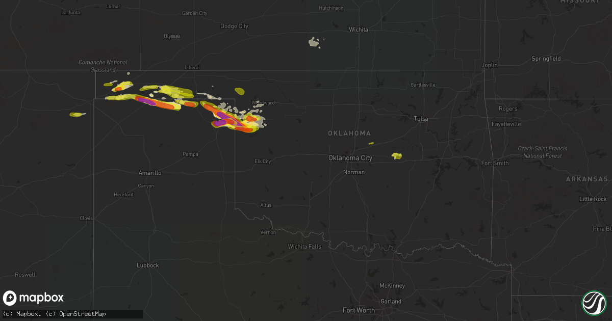
Hail Map in Oklahoma on May 30, 2018
Get this storm
May 30 map
$229
one time, instant access
Download today. No call, no setup
Keep the $229
Bought the map and want the full workflow? Apply the entire $229 to a subscription within 7 days. None of it is wasted.
Every map, not just this one
This buys you this map. Subscription and you get every map we run, in the markets you choose from a few cities to whole states to nationwide. Plus real-time alerts the moment a storm fires.
Contact data
Name, contact info, occupancy, even credit band for addresses in the footprint. You go from where it hit to who to call.
Become the source they trust
Unlimited branding weather history reports on demand. You already have the documented answer ready for the property owner, and you are the one who showed up with it.
Property data and RoofTrace estimates
Pull up any address you have got, its value and the exact code rules for that jurisdiction, straight from One Click Code. Then RoofTrace estimates the squares, pitch, and roof value, priced the way you price.
Storm reports in Oklahoma
Oklahoma
| Date | Description |
|---|---|
| 05/30/20186:47 PM CDT | Quarter sized hail reported just west of boise city. |
| 05/30/20187:34 AM CDT | At 1234 AM CDT, severe thunderstorms were located along a line extending from 2 miles east of Mannford to 5 miles north of Slick, moving east at 30 mph. HAZARD...60 mph wind gusts and quarter size hail. SOURCE...Radar indicated. IMPACT...Hail damage to vehicles is expected. Expect wind damage to roofs, siding, and trees. Locations in or near the path include... Tulsa... Broken Arrow... Sand Springs... Bixby... Sapulpa... Jenks... Glenpool... Catoosa... Mannford... Kiefer... Mounds... Kellyville... Keystone State Park... Jenks Riverside Airport... Tulsa International Airport... Liberty... Gray... Leonard...This includes Interstate 44 between mile markers 198 and 232. |
| 05/30/20187:33 AM CDT | At 1232 AM CDT, severe thunderstorms were located along a line extending from 8 miles south of Lindsay to 4 miles northwest of Velma, moving east at 60 mph. HAZARD...70 mph wind gusts and quarter size hail. SOURCE...Radar indicated. IMPACT...Hail damage to vehicles is expected. Expect considerable tree damage. Wind damage is also likely to mobile homes, roofs, and outbuildings. Locations impacted include... Pauls Valley, Sulphur, Davis, Wynnewood, Comanche, Stratford, Bray, Springer, Elmore City, Velma, Katie, Dougherty, Foster, Gene Autry, Tatums, Loco, Ratliff City, Hickory, Graham and Turner Falls. |
| 05/30/20187:09 AM CDT | At 1208 AM CDT, severe thunderstorms were located along a line extending from 5 miles north of Lake Mcmurtry to near Mulhall to 7 miles northeast of Crescent, moving east at 55 mph. Another severe storm was located 3 miles northeast of Cushing moving east at 50 mph. HAZARD...60 mph wind gusts and quarter size hail. SOURCE...Radar indicated. IMPACT...Hail damage to vehicles is expected. Expect wind damage to roofs, siding, and trees. Locations impacted include... Stillwater, Cushing, Perkins, Stroud, Langston, Yale, Morrison, Glencoe, Tryon, Ripley, Agra, Coyle, Mulhall, Orlando, Kendrick, Lake Carl Blackwell, Lake Mcmurtry, Quay, Avery and Ingalls.This includes the following highways... Interstate 35 between mile markers 163 and 180. Interstate 44 between mile markers 174 and 182. |
| 05/30/20187:06 AM CDT | At 1205 AM CDT, a severe thunderstorm was located 4 miles north of Cushing, moving east at 40 mph. HAZARD...60 mph wind gusts and quarter size hail. SOURCE...Radar indicated. IMPACT...Hail damage to vehicles is expected. Expect wind damage to roofs, siding, and trees. Locations in or near the path include... Mannford... Drumright... Oilton... Shamrock... Silver City... This includes Interstate 44 between mile markers 195 and 198. |
| 05/30/20186:28 AM CDT | At 1127 PM CDT, a severe thunderstorm was located 9 miles southwest of Bryans Corner, or 15 miles northwest of Perryton, moving east at 45 mph. HAZARD...Two inch hail and 70 mph wind gusts. SOURCE...Radar indicated. IMPACT...Expect some tree damage. Damage is likely to mobile homes, roofs, and outbuildings. People and animals outdoors will be injured. Expect hail damage to roofs, siding, windows, and vehicles. Locations impacted include... Beaver, Booker, Darrouzett, Elmwood, Bryans Corner, Adams, Boyd and Balko. |
| 05/30/20186:22 AM CDT | At 1121 PM CDT, severe thunderstorms were located along a line extending from near Waynoka to 4 miles north of Chester to 4 miles northwest of Moorewood, moving east at 45 mph. These are very dangerous storms. HAZARD...90 mph wind gusts and tennis ball size hail. SOURCE...Radar indicated. IMPACT...You are in a life-threatening situation. Flying debris may be deadly to those caught without shelter. Mobile homes will be heavily damaged or destroyed. Homes and businesses will have substantial roof and window damage. Expect extensive tree damage and power outages. Locations impacted include... Fairview, Shattuck, Arnett, Taloga, Helena, Okeene, Thomas, Waynoka, Seiling, Vici, Canton, Ringwood, Gage, Leedey, Custer City, Carmen, Cleo Springs, Longdale, Goltry and Ames. |
| 05/30/20185:40 AM CDT | At 1039 PM CDT, severe thunderstorms were located along a line extending from 7 miles south of Buffalo to 6 miles north of Fargo to 8 miles southeast of Higgins, moving southeast at 45 mph. These are very dangerous storms. HAZARD...80 mph wind gusts and tennis ball size hail. Strongest wind approaching Fort Supply and Woodward. Largest hail approaching Arnett and Harmon. SOURCE...Radar indicated. IMPACT...Flying debris will be dangerous to those caught without shelter. Mobile homes will be heavily damaged. Expect considerable damage to roofs, windows, and vehicles. Extensive tree damage and power outages are likely. Locations impacted include... Woodward, Arnett, Mooreland, Seiling, Vici, Gage, Leedey, Fargo, Fort Supply, Camargo, Sharon, Mutual, Alabaster Caverns State Park, Quinlan, Angora, Chester, Moorewood, Harmon, Cestos and Tangier. |
| 05/30/20185:40 AM CDT | At 1039 PM CDT, a severe thunderstorm was located 7 miles north of Glazier, or 8 miles south of Lipscomb, moving northeast at 50 mph. HAZARD...60 mph wind gusts and quarter size hail. SOURCE...Radar indicated. IMPACT...Minor damage to roofs, siding, and trees is possible. Hail damage to vehicles is expected. Locations impacted include... Lipscomb, Canadian, Follett, Higgins, Glazier and Lake Marvin. |
| 05/30/20185:10 AM CDT | Weleetka police dept reports power lines down 1 mile south of town. Numerous small tree limbs down in town. Time estimated by radar. |
| 05/30/20184:25 AM CDT | Numerous 6 to 7 inch tree limbs downed just west of paden on us-62. Time estimated by radar. |
| 05/30/20183:17 AM CDT | Large tree down |
| 05/30/20183:08 AM CDT | At 807 PM CDT, a severe thunderstorm was located over Goodwell, or 10 miles southwest of Guymon, moving east at 40 mph. HAZARD...Ping pong ball size hail and 60 mph wind gusts. SOURCE...Radar indicated. IMPACT...Minor damage to roofs, siding, and trees is possible. People and animals outdoors will be injured. Expect hail damage to roofs, siding, windows, and vehicles. Locations impacted include... Guymon, Hooker, Goodwell, Optima, Hardesty, Baker, Adams and Turpin. |
| 05/30/20183:05 AM CDT | At 804 PM CDT, a severe thunderstorm was located 8 miles south of Texhoma, or 16 miles east of Stratford, moving southeast at 40 mph. HAZARD...Two inch hail and 70 mph wind gusts. SOURCE...An NWS Employee and Storm Chasers reporting 65 MPH winds and flipped semi-trucks 7 miles southwest of Texhoma. IMPACT...Expect some tree damage. Damage is likely to mobile homes, roofs, and outbuildings. People and animals outdoors will be injured. Expect hail damage to roofs, siding, windows, and vehicles. Locations impacted include... Spearman, Gruver and Texhoma. |
| 05/30/20182:50 AM CDT | Large tree down in town. Time estimated by radar. |
| 05/30/20182:25 AM CDT | Several large trees blocking road west of town. Time estimated by radar. |
| 05/30/20182:05 AM CDT | 2-3 inch tree limbs down. Time estimated by radar. |
| 05/30/20181:55 AM CDT | Numerous tree limbs down in town. |
| 05/30/20181:55 AM CDT | At 654 PM CDT, a severe thunderstorm was located 11 miles north of Keyes, or 16 miles west of Elkhart, moving northeast at 30 mph. HAZARD...60 mph wind gusts and quarter size hail. SOURCE...Radar indicated. IMPACT...Hail damage to vehicles is expected. Expect wind damage to roofs, siding, and trees. Locations impacted include... Elkhart, Rolla, Richfield and Wilburton. |
| 05/30/20181:55 AM CDT | A local report indicates 58 MPH wind near 2 NNW PERKINS |
| 05/30/20181:40 AM CDT | Four inch diameter tree limb blown off live maple tree. |
| 05/30/20181:40 AM CDT | A local report indicates 63 MPH wind near 8 E NEWKIRK |
| 05/30/20181:40 AM CDT | Late report. Tree damage near simmons and coltrane. Time estimated by radar. |
| 05/30/20181:30 AM CDT | At 630 AM CDT, a severe thunderstorm was located near Nida, moving southeast at 20 mph. HAZARD...60 mph wind gusts and quarter size hail. SOURCE...Radar indicated. IMPACT...Hail damage to vehicles is expected. Expect wind damage to roofs, siding, and trees. Locations impacted include... Durant, Bokchito, Achille, Silo, Kemp, Mead, Armstrong, Blue, Utica, Nida and Calera. |
| 05/30/20181:30 AM CDT | A local report indicates 63 MPH wind near GUTHRIE |
| 05/30/20181:30 AM CDT | Tree damage... One outbuilding overturned... A few barns with some tin blown off roof. |
| 05/30/20181:30 AM CDT | A local report indicates 58 MPH wind near 3 WNW GUTHRIE |
| 05/30/20181:18 AM CDT | At 618 PM CDT, a severe thunderstorm was located 7 miles northwest of Boise City, moving east at 50 mph. HAZARD...60 mph wind gusts and quarter size hail. SOURCE...Radar indicated. IMPACT...Minor damage to roofs, siding, and trees is possible. Hail damage to vehicles is expected. Locations impacted include... Boise City, Keyes, Eva, Griggs and Sturgis. |
| 05/30/20181:15 AM CDT | A local report indicates 59 MPH wind near 4 SSE MARSHALL |
| 05/30/201812:45 AM CDT | A local report indicates 68 MPH wind near 3 SE BRECKENRIDGE |
| 05/30/201812:40 AM CDT | A local report indicates 67 MPH wind near 3 SE BRECKENRIDGE |
| 05/30/201812:30 AM CDT | A local report indicates 63 MPH wind near GUTHRIE |
| 05/30/201812:22 AM CDT | Along hwy 283 |
| 05/30/201812:15 AM CDT | A local report indicates 60 MPH wind near 4 SSE MARSHALL |
| 05/30/201812:15 AM CDT | A local report indicates 61 MPH wind near 5 SW BLACKWELL |
| 05/29/201811:45 PM CDT | A local report indicates 58 MPH wind near 7 SSW ALVA |
| 05/29/201811:35 PM CDT | At the camargo mesonet. |
| 05/29/201811:30 PM CDT | Wind direction west-northwest |
| 05/29/201811:25 PM CDT | Late report. An outbuilding was destroyed and damage occurred to street signs... A fence... Siding... And a tin roof in and near vici. Time estimated by radar. |
| 05/29/201811:19 PM CDT | Wind direction from the northwest. |
| 05/29/201811:14 PM CDT | A local report indicates 70 MPH wind near VICI |
| 05/29/201811:07 PM CDT | Tree... Power pole... And several tree limbs blown down. |
| 05/29/201811:00 PM CDT | Late report. Some damage to buildings in mooreland... Including roof damage to mooreland elementary school. Time estimated by radar. |
| 05/29/201810:56 PM CDT | A local report indicates 59 MPH wind near WOODWARD |
| 05/29/201810:55 PM CDT | Picture via social media showed quarter sized hail. |
| 05/29/201810:55 PM CDT | Power lines and pole down in sharon. Powerlines down in ft. Supply as well |
| 05/29/201810:55 PM CDT | A local report indicates 66 MPH wind near 6 W WOODWARD |
| 05/29/201810:55 PM CDT | Carport and two sheds destroyed. Roof blown off mobile home on the west side of town. Timed based on radar. |
| 05/29/201810:50 PM CDT | One inch diameter hail fell near guymon. |
| 05/29/201810:47 PM CDT | Received via spotter network. Time estimated by radar. |
| 05/29/201810:35 PM CDT | On hwy 60 |
| 05/29/201810:25 PM CDT | Hwy 60 on east side of arnett |
| 05/29/201810:05 PM CDT | Ping pong ball sized hail southeast of boise city. |
| 05/29/20189:40 PM CDT | 59 mph wind gust reported at beaver mesonet. |
| 05/29/20189:22 PM CDT | Quarter sized hail in boise city. |
| 05/29/20189:15 PM CDT | A local report indicates 1.00 inch wind near BOISE CITY |
| 05/29/20188:21 PM CDT | At 121 AM CDT, severe thunderstorms were located along a line extending from 2 miles south of Oneta to 3 miles northwest of Boynton, moving east at 45 mph. HAZARD...60 mph wind gusts and quarter size hail. SOURCE...Radar indicated. IMPACT...Hail damage to vehicles is expected. Expect wind damage to roofs, siding, and trees. Locations in or near the path include... Broken Arrow... Muskogee... Wagoner... Coweta... Fort Gibson... Haskell... Okay... Hulbert... Porter... Braggs... Taft... Boynton... Tullahassee... Greenleaf State Park... Pumpkin Center... Sequoyah State Park... Keefeton... Oneta... Wainwright... Summit... |
| 05/29/20188:15 PM CDT | Spotter measured estimated 60 mph wind gust. |
| 05/29/20188:07 PM CDT | At 107 AM CDT, severe thunderstorms were located along a line extending from 3 miles northeast of Elmore City to 4 miles northeast of Milo to 5 miles northwest of Ringling, moving east at 20 mph. HAZARD...70 mph wind gusts and quarter size hail. SOURCE...Radar indicated. IMPACT...Hail damage to vehicles is expected. Expect considerable tree damage. Wind damage is also likely to mobile homes, roofs, and outbuildings. Locations impacted include... Ardmore, Sulphur, Davis, Lone Grove, Healdton, Wynnewood, Wilson, Ringling, Springer, Elmore City, Katie, Dougherty, Foster, Gene Autry, Tatums, Ratliff City, Graham, Pooleville, Lake Of The Arbuckles and Turner Falls.This includes Interstate 35 between mile markers 31 and 67. |
| 05/29/20187:40 PM CDT | Eva mesonet reported 60 mph wind gust. |
| 05/29/20187:21 PM CDT | Trained spotter measured 1.2 inch maximum hail size. |
All States Impacted by Hail Map on May 30, 2018
Cities Impacted by Hail Map on May 30, 2018
- Keyes, OK
- Larkspur, CO
- Franktown, CO
- Monument, CO
- Colorado Springs, CO
- Meridian, MS
- Toomsuba, MS
- Follett, TX
- Lisman, AL
- Boise, ID
- Garden City, ID
- Gruver, TX
- Arnett, OK
- Peyton, CO
- Elbert, CO
- Arapahoe, CO
- Boise City, OK
- Canadian, TX
- Higgins, TX
- Crawford, OK
- Perryton, TX
- Booker, TX
- Lipscomb, TX
- Matheson, CO
- Limon, CO
- Schlater, MS
- Minter City, MS
- Doddsville, MS
- Ruleville, MS
- Elizabeth, CO
- Alamo, ND
- Grenora, ND
- Zahl, ND
- Spivey, KS
- Nashville, KS
- Zenda, KS
- Texhoma, OK
- Felt, OK
- Texhoma, TX
- Stratford, TX
- Dalhart, TX
- Spearman, TX
- Boulder, CO
- Jamestown, CO
- Hardesty, OK
- Clayton, NM
- Rush, CO
- Yoder, CO
- Aneta, ND
- Durant, OK
- Woodward, OK
- Kiowa, CO
- Goodwell, OK
- Calhan, CO
- Nampa, ID
- Caldwell, ID
- Murphy, ID
- Melba, ID
- Pueblo, CO
- Camargo, OK
- Massena, IA
- Broadus, MT
- Collinsville, MS
- Fargo, OK
- Cope, CO
- Fort Morgan, CO
- Balko, OK
- Kirk, CO
- Attica, KS
- Beaver, OK
- Shattuck, OK
- Joes, CO
- Yuma, CO
- De Kalb, MS
- Bailey, MS
- Vici, OK
- Leedey, OK
- Sharon, OK
- Weskan, KS
- Cartwright, ND
- Guymon, OK
- Karlstad, MN
- Hazelton, ID
- Murtaugh, ID
- Boley, OK
- Bokchito, OK
- Hendrix, OK
- Tremonton, UT
- Vona, CO
- Gage, OK
- Paden, OK
- Okemah, OK
- Hansen, ID
- Malta, ID
- Senatobia, MS
- Marion, MS
- Quitman, MS
- Cascade, MT
- Kenton, OK
- Keenesburg, CO
- Hudson, CO
- Sand Springs, MT
- Alexander, ND
- Kingman, KS
- Daleville, MS
- Kuna, ID
- Prague, OK
- Boligee, AL
- Laverne, OK
- Tonkawa, OK
- Cunningham, KS
- Anton, CO
- Akron, CO
- Durham, OK
- Wellston, OK
- Mosby, MT
- Winnett, MT
- Brusett, MT
- Jordan, MT
- Circle, MT
- Little Rock, MS


