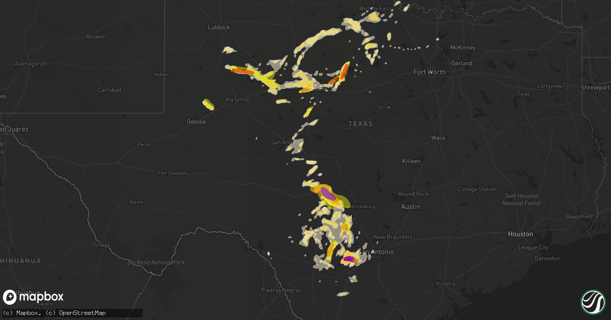
Hail Map in Texas on May 28, 2016
Get this storm
May 28 map
$229
one time, instant access
Download today. No call, no setup
Keep the $229
Bought the map and want the full workflow? Apply the entire $229 to a subscription within 7 days. None of it is wasted.
Every map, not just this one
This buys you this map. Subscription and you get every map we run, in the markets you choose from a few cities to whole states to nationwide. Plus real-time alerts the moment a storm fires.
Contact data
Name, contact info, occupancy, even credit band for addresses in the footprint. You go from where it hit to who to call.
Become the source they trust
Unlimited branding weather history reports on demand. You already have the documented answer ready for the property owner, and you are the one who showed up with it.
Property data and RoofTrace estimates
Pull up any address you have got, its value and the exact code rules for that jurisdiction, straight from One Click Code. Then RoofTrace estimates the squares, pitch, and roof value, priced the way you price.
Storm reports in Texas
Texas
| Date | Description |
|---|---|
| 05/28/20166:56 PM CDT | A local report indicates 1.75 inch wind near 3 S LONDON |
| 05/28/20166:55 PM CDT | Quarter size hail and flooding of low lying areas reported on fm 644 north of hermleigh |
| 05/28/20166:30 PM CDT | Near highway 173 south of hondo |
| 05/28/20166:12 PM CDT | A local report indicates 1.75 inch wind near 5 SSE HONDO |
| 05/28/20165:45 PM CDT | Ping pong ball to golf ball size hail found on the ground along highway 83. |
| 05/28/20165:30 PM CDT | Quarter to half dollar size hail approximately 1 mile northwest of winters. |
| 05/28/20164:04 AM CDT | Penny to quarter sized hail and wind gusts to 55 mph estimated by spotter. Several large outdoor objects displaced. |
| 05/28/20163:50 AM CDT | Thunderstorm wind gusts damaged a church roof and tall road sign at the corner of big mesa drive and buffalo pass drive |
| 05/28/20163:45 AM CDT | Wind gusts blew down a section of new wooden fencing in the rolling oaks estates subdivision |
| 05/28/20163:11 AM CDT | Public reported shingles off a house...tree down...and trampoline down the street. Damage reported in lake shore estates. |
| 05/28/20162:45 AM CDT | West side of runaway bay |
| 05/28/20161:00 AM CDT | Large tree branches down. |
| 05/28/201612:45 AM CDT | Damaging thunderstorm winds knocked over a swing set. Wind were estimated to be around 70 mph. |
| 05/27/201610:35 PM CDT | Winston field awos measured thunderstorm wind gust of 53 knots |
| 05/27/201610:05 PM CDT | Thunderstorm wind gust reported at the quiet valley ranch on highway 16 |
| 05/27/201610:05 PM CDT | A local report indicates 1.25 inch wind near 3 NNW HAMLIN |
| 05/27/20169:55 PM CDT | A local report indicates 1.75 inch wind near 10 SSE UTOPIA |
| 05/27/20169:54 PM CDT | A local report indicates 1.00 inch wind near 10 N SABINAL |
| 05/27/20169:50 PM CDT | Quarter sized hail was reported about a half mile nne of sabinal. |
| 05/27/20169:30 PM CDT | Hail sizes ranged from one half inch to one and one quarter inch |
| 05/27/20169:05 PM CDT | Reported via social media |
| 05/27/20169:05 PM CDT | Reported via social media |
| 05/27/20169:05 PM CDT | A few quarter size hailstones mixed in with mostly nickel size hail |
| 05/27/20168:50 PM CDT | Report from borden county sheriffs office |
| 05/27/20168:50 PM CDT | Hail reported near the intersection of highway 290 and reeh road |
| 05/27/20168:46 PM CDT | Dime to half dollar size hail southwest of tye |
| 05/27/20168:35 PM CDT | A local report indicates 1.75 inch wind near 3 W HARPER |
| 05/27/20168:23 PM CDT | Quarter to billiard ball size hail stones found along fm 1235 southeast of merkel. |
| 05/27/20168:20 PM CDT | A local report indicates 1.75 inch wind near 7 E ALBANY |
| 05/27/20168:17 PM CDT | Quarter size hail reported along interstate 10. |
| 05/27/20168:13 PM CDT | A local report indicates 2.00 inch wind near 19 E SEGOVIA |
| 05/27/20168:07 PM CDT | Hail was ongoing |
| 05/27/20167:50 PM CDT | A local report indicates 1.75 inch wind near 1 NNW CAMP VERDE |
| 05/27/20167:50 PM CDT | A local report indicates 1.75 inch wind near 7 S ALBANY |
| 05/27/20167:40 PM CDT | Storm chasers recorded video of a cone tornado approximately 15 miles east of junction. Tornado was on the ground for approximately 10 minutes. |
| 05/27/20167:22 PM CDT | A local report indicates 1.25 inch wind near 6 SW LONDON |
| 05/27/20167:22 PM CDT | Hail was ongoing |
| 05/27/20167:05 PM CDT | Picture shows hailstones approximately the size of an actual softball |
All States Impacted by Hail Map on May 28, 2016
Cities Impacted by Hail Map on May 28, 2016
- Mereta, TX
- Eola, TX
- San Angelo, TX
- Paint Rock, TX
- Ryan, OK
- McCaulley, TX
- Sylvester, TX
- Ballinger, TX
- Talpa, TX
- Albany, TX
- Breckenridge, TX
- Tahoka, TX
- Stanton, TX
- Dyess Afb, TX
- Hawley, TX
- Merkel, TX
- Abilene, TX
- Anson, TX
- Sweetwater, TX
- Trent, TX
- Tye, TX
- Uvalde, TX
- Bandera, TX
- Rio Medina, TX
- Moore, TX
- Castroville, TX
- Hondo, TX
- San Antonio, TX
- Devine, TX
- D Hanis, TX
- La Coste, TX
- Yancey, TX
- Menard, TX
- Eden, TX
- Hunt, TX
- Tarpley, TX
- Leakey, TX
- Medina, TX
- Vanderpool, TX
- Utopia, TX
- Kerrville, TX
- Arena, WI
- Black Earth, WI
- Mazomanie, WI
- Blue Mounds, WI
- Barneveld, WI
- Holliday, TX
- Seymour, TX
- Moran, TX
- Baird, TX
- Clinton, IA
- Gail, TX
- Junction, TX
- Mountain Home, TX
- Graham, TX
- Atlanta, IL
- Maryneal, TX
- Brinktown, MO
- Dixon, MO
- Rotan, TX
- Snyder, TX
- Sullivan, MO
- Richwoods, MO
- Bourbon, MO
- Cuba, MO
- Lonedell, MO
- Blackwell, TX
- Colorado City, TX
- Hermleigh, TX
- Loraine, TX
- Roscoe, TX
- Fluvanna, TX
- Rushville, IL
- Sabinal, TX
- Knippa, TX
- Vienna, MO
- Camp Point, IL
- Coatsburg, IL
- Golden, IL
- Clayton, IL
- Huntsville, IL
- La Prairie, IL
- Camden, IL
- Mason City, IL
- San Jose, IL
- Easton, IL
- Delavan, IL
- Green Valley, IL
- Christoval, TX
- Walnut, IL
- Del Rio, TX
- Laughlin Afb, TX
- Shabbona, IL
- Earlville, IL
- Waterman, IL
- Mcalester, OK
- Mechanicsville, IA
- Anamosa, IA
- Olin, IA
- Morley, IA
- Sanger, TX
- Harper, TX
- Munday, TX
- O'Brien, TX
- Knox City, TX
- Rule, TX
- Rochester, TX
- Goree, TX
- Clyde, TX
- Bryson, TX
- Armington, IL
- Old Glory, TX
- Aspermont, TX
- Winters, TX
- Beardstown, IL
- Rio Frio, TX
- Concan, TX
- Meta, MO
- Galesburg, IL
- Henrietta, TX
- Barksdale, TX
- Camp Wood, TX
- Vancourt, TX
- Scotland, TX
- Wichita Falls, TX
- Olney, TX
- Ingram, TX
- Edgemont, SD
- Fulton, IL
- Dublin, TX
- Ava, MO
- Drury, MO
- Norwood, MO
- Mason, TX
- Rocksprings, TX
- London, TX
- Fredericksburg, TX
- De Soto, MO
- Fletcher, MO
- Dittmer, MO
- Midland, TX
- Licking, MO
- Success, MO
- Buffalo Gap, TX
- Cotulla, TX
- Woodson, TX
- Houlka, MS
- Jacksboro, TX
- Chetek, WI
- New Auburn, WI
- Ira, TX
- Stoutland, MO
- Richland, MO
- Hillsboro, IA
- Rolla, MO
- Potosi, MO
- Deridder, LA
- Newcastle, TX
- Roby, MO
- Bucyrus, MO
- Graford, TX
- Hamlin, TX
- Miles, TX
- Graff, MO
- Huggins, MO
- Mountain Grove, MO
- Mansfield, MO
- Squires, MO
- McLean, IL
- Comfort, TX
- Center Point, TX
- Lincoln, IL
- Hartsburg, IL
- Pearsall, TX
- Belle, MO
- Celina, OH
- Vardaman, MS
- Helotes, TX
- Loving, TX
- Browning, IL
- Bath, IL
- Havana, IL
- Topeka, IL
- Astoria, IL
- Liverpool, IL
- Lewistown, IL
- Manito, IL
- Newburg, MO
- Batesville, TX
- Stuart, OK
- Houma, LA
- Gray, LA
- Wall, TX
- Lawn, TX
- Ovalo, TX
- Randolph, MS
- Weinert, TX
- Lamesa, TX
- Nocona, TX
- Crocker, MO
- Singer, LA
- Bowie, TX
- Pewaukee, WI
- Sussex, WI
- Waukesha, WI
- Dilley, TX
- Forest City, IL
- Saint James, MO
- Bland, MO
- Vichy, MO
- Iberia, MO
- Hubertus, WI
- Germantown, WI
- Richfield, WI
- Ardmore, OK
- Lisco, NE
- Mill Creek, OK
- Berger, MO
- Stephenville, TX
- Bellevue, IA
- Boerne, TX
- Brady, TX
- Lewellen, NE
- Rock Island, IL
- Norton, TX
- Leland, IL
- Quincy, IL
- Fowler, IL
- Cameron, IL
- Otis, CO
- Juneau, WI
- Beaver Dam, WI
- Dodgeville, WI
- Mineral Point, WI
- Vanzant, MO
- Griggsville, IL
- Atascosa, TX
- Natalia, TX
- Pipe Creek, TX
- Brackettville, TX
- Lytle, TX
- Mico, TX
- Vermont, IL
- Industry, IL
- Ridgeway, WI
- Spring Green, WI
- Post, TX
- Emden, IL
- Bellevue, TX
- Geneseo, IL
- Eureka, IL
- Plato, MO
- Edgar Springs, MO
- Lueders, TX
- Atkinson, IL
- Gothenburg, NE
- Callaway, NE
- Bridgeport, TX
- Paradise, TX
- Jbsa Lackland, TX
- Von Ormy, TX
- Mount Sterling, IL
- Lodi, WI
- Sterling City, TX
- Owensville, MO
- Rosebud, MO
- Gerald, MO
- Leesville, LA
- Chandlerville, IL
- Minier, IL
- Hopedale, IL
- Stanford, IL
- Potosi, WI
- Ponder, TX
- Tuscola, TX
- Dubuque, IA
- Myrtle, MS
- Hickory Flat, MS
- Fort Leonard Wood, MO
- Brandon, WI
- Markesan, WI
- Dekalb, IL
- Ranger, TX
- Pontotoc, MS
- Sheffield, IL
- Decatur, TX
- Thomson, IL
- Sharon, TN
- Deer Grove, IL
- Lone Grove, OK
- Ipava, IL
- Cambridge, IL
- Fort Worth, TX
- Roby, TX
- Wilson, OK
- McNabb, IL
- Magnolia, IL
- Lostant, IL
- Alliance, NE
- Doss, TX


