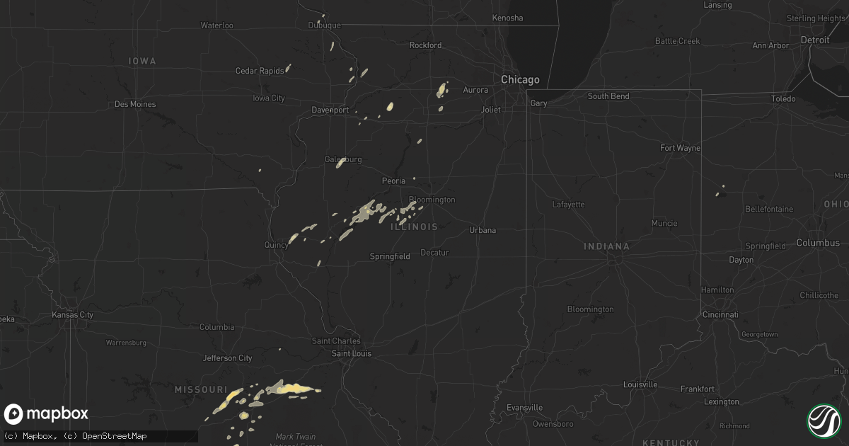
Hail Map in Illinois on May 28, 2016
Get this storm
May 28 map
$229
one time, instant access
Download today. No call, no setup
Keep the $229
Bought the map and want the full workflow? Apply the entire $229 to a subscription within 7 days. None of it is wasted.
Every map, not just this one
This buys you this map. Subscription and you get every map we run, in the markets you choose from a few cities to whole states to nationwide. Plus real-time alerts the moment a storm fires.
Contact data
Name, contact info, occupancy, even credit band for addresses in the footprint. You go from where it hit to who to call.
Become the source they trust
Unlimited branding weather history reports on demand. You already have the documented answer ready for the property owner, and you are the one who showed up with it.
Property data and RoofTrace estimates
Pull up any address you have got, its value and the exact code rules for that jurisdiction, straight from One Click Code. Then RoofTrace estimates the squares, pitch, and roof value, priced the way you price.
Storm reports in Illinois
Illinois
| Date | Description |
|---|---|
| 05/28/20166:00 PM CDT | 3 to 6 inch diameter tree limbs down. Time estimated from radar. Recieved via social media. |
| 05/28/20165:10 PM CDT | Power pole snapped and numerous trees blown down on the west side of town. Same report received from public via facebook. |
| 05/27/20168:30 PM CDT | Relayed via twitter. |
| 05/27/20168:27 PM CDT | Measured on a personal weather station 1 mile south of interstate 88. |
| 05/27/20168:15 PM CDT | Four trees blown down |
| 05/27/20167:18 PM CDT | Several trees and a powerpole blown down at the lee county fair grounds. |
| 05/27/20167:15 PM CDT | Structural damage to a building in town...a number of trees down...2700 people without power in the county. |
All States Impacted by Hail Map on May 28, 2016
Cities Impacted by Hail Map on May 28, 2016
- Mereta, TX
- Eola, TX
- San Angelo, TX
- Paint Rock, TX
- Ryan, OK
- McCaulley, TX
- Sylvester, TX
- Ballinger, TX
- Talpa, TX
- Albany, TX
- Breckenridge, TX
- Tahoka, TX
- Stanton, TX
- Dyess Afb, TX
- Hawley, TX
- Merkel, TX
- Abilene, TX
- Anson, TX
- Sweetwater, TX
- Trent, TX
- Tye, TX
- Uvalde, TX
- Bandera, TX
- Rio Medina, TX
- Moore, TX
- Castroville, TX
- Hondo, TX
- San Antonio, TX
- Devine, TX
- D Hanis, TX
- La Coste, TX
- Yancey, TX
- Menard, TX
- Eden, TX
- Hunt, TX
- Tarpley, TX
- Leakey, TX
- Medina, TX
- Vanderpool, TX
- Utopia, TX
- Kerrville, TX
- Arena, WI
- Black Earth, WI
- Mazomanie, WI
- Blue Mounds, WI
- Barneveld, WI
- Holliday, TX
- Seymour, TX
- Moran, TX
- Baird, TX
- Clinton, IA
- Gail, TX
- Junction, TX
- Mountain Home, TX
- Graham, TX
- Atlanta, IL
- Maryneal, TX
- Brinktown, MO
- Dixon, MO
- Rotan, TX
- Snyder, TX
- Sullivan, MO
- Richwoods, MO
- Bourbon, MO
- Cuba, MO
- Lonedell, MO
- Blackwell, TX
- Colorado City, TX
- Hermleigh, TX
- Loraine, TX
- Roscoe, TX
- Fluvanna, TX
- Rushville, IL
- Sabinal, TX
- Knippa, TX
- Vienna, MO
- Camp Point, IL
- Coatsburg, IL
- Golden, IL
- Clayton, IL
- Huntsville, IL
- La Prairie, IL
- Camden, IL
- Mason City, IL
- San Jose, IL
- Easton, IL
- Delavan, IL
- Green Valley, IL
- Christoval, TX
- Walnut, IL
- Del Rio, TX
- Laughlin Afb, TX
- Shabbona, IL
- Earlville, IL
- Waterman, IL
- Mcalester, OK
- Mechanicsville, IA
- Anamosa, IA
- Olin, IA
- Morley, IA
- Sanger, TX
- Harper, TX
- Munday, TX
- O'Brien, TX
- Knox City, TX
- Rule, TX
- Rochester, TX
- Goree, TX
- Clyde, TX
- Bryson, TX
- Armington, IL
- Old Glory, TX
- Aspermont, TX
- Winters, TX
- Beardstown, IL
- Rio Frio, TX
- Concan, TX
- Meta, MO
- Galesburg, IL
- Henrietta, TX
- Barksdale, TX
- Camp Wood, TX
- Vancourt, TX
- Scotland, TX
- Wichita Falls, TX
- Olney, TX
- Ingram, TX
- Edgemont, SD
- Fulton, IL
- Dublin, TX
- Ava, MO
- Drury, MO
- Norwood, MO
- Mason, TX
- Rocksprings, TX
- London, TX
- Fredericksburg, TX
- De Soto, MO
- Fletcher, MO
- Dittmer, MO
- Midland, TX
- Licking, MO
- Success, MO
- Buffalo Gap, TX
- Cotulla, TX
- Woodson, TX
- Houlka, MS
- Jacksboro, TX
- Chetek, WI
- New Auburn, WI
- Ira, TX
- Stoutland, MO
- Richland, MO
- Hillsboro, IA
- Rolla, MO
- Potosi, MO
- Deridder, LA
- Newcastle, TX
- Roby, MO
- Bucyrus, MO
- Graford, TX
- Hamlin, TX
- Miles, TX
- Graff, MO
- Huggins, MO
- Mountain Grove, MO
- Mansfield, MO
- Squires, MO
- McLean, IL
- Comfort, TX
- Center Point, TX
- Lincoln, IL
- Hartsburg, IL
- Pearsall, TX
- Belle, MO
- Celina, OH
- Vardaman, MS
- Helotes, TX
- Loving, TX
- Browning, IL
- Bath, IL
- Havana, IL
- Topeka, IL
- Astoria, IL
- Liverpool, IL
- Lewistown, IL
- Manito, IL
- Newburg, MO
- Batesville, TX
- Stuart, OK
- Houma, LA
- Gray, LA
- Wall, TX
- Lawn, TX
- Ovalo, TX
- Randolph, MS
- Weinert, TX
- Lamesa, TX
- Nocona, TX
- Crocker, MO
- Singer, LA
- Bowie, TX
- Pewaukee, WI
- Sussex, WI
- Waukesha, WI
- Dilley, TX
- Forest City, IL
- Saint James, MO
- Bland, MO
- Vichy, MO
- Iberia, MO
- Hubertus, WI
- Germantown, WI
- Richfield, WI
- Ardmore, OK
- Lisco, NE
- Mill Creek, OK
- Berger, MO
- Stephenville, TX
- Bellevue, IA
- Boerne, TX
- Brady, TX
- Lewellen, NE
- Rock Island, IL
- Norton, TX
- Leland, IL
- Quincy, IL
- Fowler, IL
- Cameron, IL
- Otis, CO
- Juneau, WI
- Beaver Dam, WI
- Dodgeville, WI
- Mineral Point, WI
- Vanzant, MO
- Griggsville, IL
- Atascosa, TX
- Natalia, TX
- Pipe Creek, TX
- Brackettville, TX
- Lytle, TX
- Mico, TX
- Vermont, IL
- Industry, IL
- Ridgeway, WI
- Spring Green, WI
- Post, TX
- Emden, IL
- Bellevue, TX
- Geneseo, IL
- Eureka, IL
- Plato, MO
- Edgar Springs, MO
- Lueders, TX
- Atkinson, IL
- Gothenburg, NE
- Callaway, NE
- Bridgeport, TX
- Paradise, TX
- Jbsa Lackland, TX
- Von Ormy, TX
- Mount Sterling, IL
- Lodi, WI
- Sterling City, TX
- Owensville, MO
- Rosebud, MO
- Gerald, MO
- Leesville, LA
- Chandlerville, IL
- Minier, IL
- Hopedale, IL
- Stanford, IL
- Potosi, WI
- Ponder, TX
- Tuscola, TX
- Dubuque, IA
- Myrtle, MS
- Hickory Flat, MS
- Fort Leonard Wood, MO
- Brandon, WI
- Markesan, WI
- Dekalb, IL
- Ranger, TX
- Pontotoc, MS
- Sheffield, IL
- Decatur, TX
- Thomson, IL
- Sharon, TN
- Deer Grove, IL
- Lone Grove, OK
- Ipava, IL
- Cambridge, IL
- Fort Worth, TX
- Roby, TX
- Wilson, OK
- McNabb, IL
- Magnolia, IL
- Lostant, IL
- Alliance, NE
- Doss, TX


