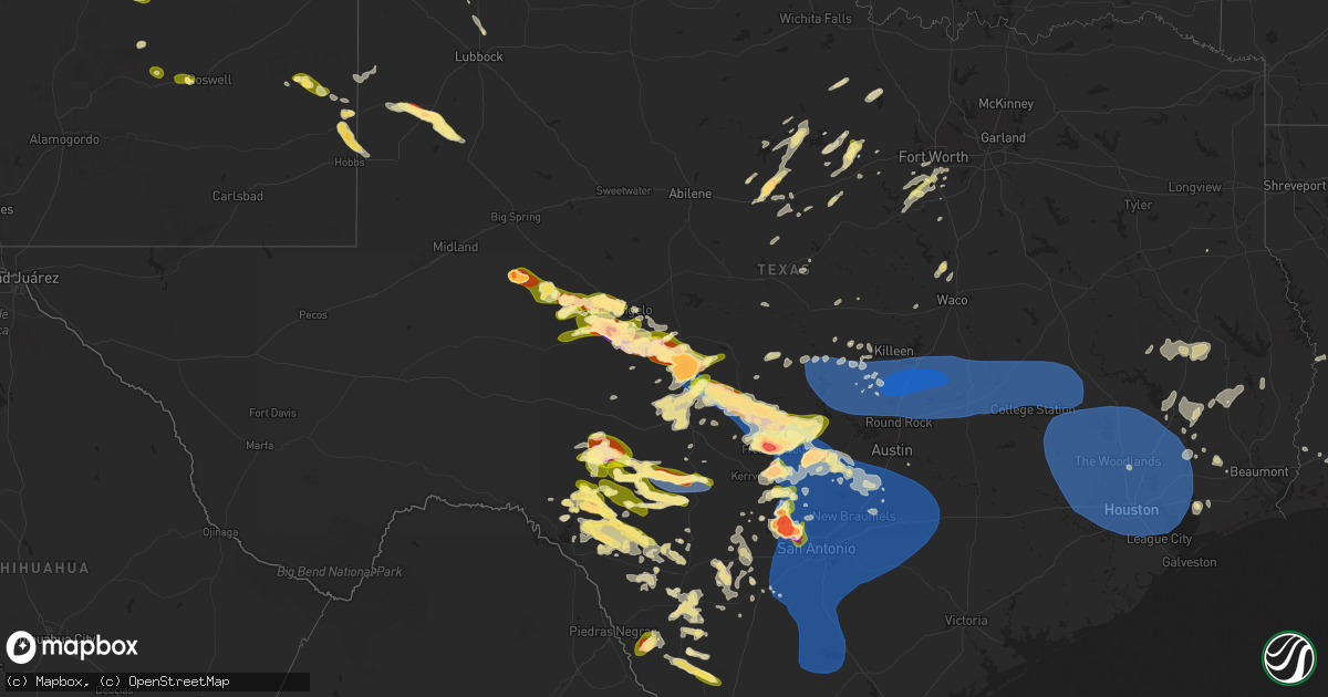
Hail Map in Texas on May 26, 2025
Get this storm
May 26 map
$229
one time, instant access
Download today. No call, no setup
Keep the $229
Bought the map and want the full workflow? Apply the entire $229 to a subscription within 7 days. None of it is wasted.
Every map, not just this one
This buys you this map. Subscription and you get every map we run, in the markets you choose from a few cities to whole states to nationwide. Plus real-time alerts the moment a storm fires.
Contact data
Name, contact info, occupancy, even credit band for addresses in the footprint. You go from where it hit to who to call.
Become the source they trust
Unlimited branding weather history reports on demand. You already have the documented answer ready for the property owner, and you are the one who showed up with it.
Property data and RoofTrace estimates
Pull up any address you have got, its value and the exact code rules for that jurisdiction, straight from One Click Code. Then RoofTrace estimates the squares, pitch, and roof value, priced the way you price.
Storm reports in Texas
Texas
| Date | Description |
|---|---|
| 05/26/20256:50 PM CDT | A local report indicates 2.50 inch wind near Groom |
| 05/26/20256:50 PM CDT | Corrects a previous report of location and hail in groom. 2 to 2.5 inch hail fell at this location. |
| 05/26/20256:40 PM CDT | Hail up to quarter sized occurred along county road x. |
| 05/26/20256:29 PM CDT | A local report indicates 2.00 inch wind near 3 NW Loyal Valley |
| 05/26/20256:25 PM CDT | The public reported multiple snapped power poles along with 3.25 inch hail. |
| 05/26/20256:13 PM CDT | A trained spotter reported 3 to 3.5 inch hail. |
| 05/26/20256:08 PM CDT | The public reported ping pong to baseball size hail. |
| 05/26/20256:03 PM CDT | Report from mping: golf ball |
| 05/26/20256:03 PM CDT | A local report indicates 2.75 inch wind near 1 N Christoval |
| 05/26/20256:00 PM CDT | Report from mping: quarter |
| 05/26/20256:00 PM CDT | A spotter measured 3.75 inch hail. |
| 05/26/20255:57 PM CDT | Report from mping: baseball++ |
| 05/26/20255:53 PM CDT | Report from mping. |
| 05/26/20255:47 PM CDT | Report from mping: quarter |
| 05/26/20255:46 PM CDT | Report from mping. |
| 05/26/20255:46 PM CDT | Report from mping: quarter |
| 05/26/20255:43 PM CDT | A local report indicates 1.00 inch wind near 2 E Tankersley |
| 05/26/20255:38 PM CDT | A local report indicates 1.25 inch wind near 3 W Tankersley |
| 05/26/20255:37 PM CDT | A local report indicates 1.00 inch wind near 2 NNE San Angelo |
| 05/26/20255:33 PM CDT | Report from mping: ping pong ball |
| 05/26/20255:28 PM CDT | Report from mping: quarter |
| 05/26/20255:22 PM CDT | Report from mping: quarter |
| 05/26/20255:21 PM CDT | A local report indicates 1.00 inch wind near Godley |
| 05/26/20255:20 PM CDT | A local report indicates 1.75 inch wind near 5 S Grape Creek |
| 05/26/20254:23 PM CDT | A storm chaser posted pictures on social media and indicated that they measured hail stones between 5.51 to 5.90 inches. |
| 05/26/20254:23 PM CDT | Corrects previous hail report from 1 wnw menard. Icechip. A storm chaser posted pictures on social media and indicated that they measured hail stones between 5.51 to 5. |
| 05/26/20254:22 PM CDT | Report from mping: half dollar |
| 05/26/20254:20 PM CDT | A local report indicates 1.50 inch wind near 1 S Tankersley |
| 05/26/20254:15 PM CDT | Report from mping: baseball+ |
| 05/26/20254:13 PM CDT | A trained |
| 05/26/20254:13 PM CDT | A trained spotter reported a tornado just southwest of menard. |
| 05/26/20254:12 PM CDT | A local report indicates 73 MPH wind near 2 WNW Menard |
| 05/26/20254:03 PM CDT | Report from mping: quarter |
| 05/26/20253:50 PM CDT | The report was received through social media. |
| 05/26/20253:42 PM CDT | Golf ball sized hail reported a few miles southeast of garden city. Occasionally larger hail stones observed... But infrequent. |
| 05/26/20253:27 PM CDT | Report from mping: golf ball |
| 05/26/20253:24 PM CDT | Report of hen egg sized hail near rm 33... South of garden city. |
| 05/26/20252:17 PM CDT | A local report indicates 1.50 inch wind near 8 NNE Christoval |
| 05/26/20251:53 PM CDT | Report from mping. |
| 05/26/20251:14 PM CDT | Report from mping. |
| 05/26/20251:10 PM CDT | Report from mping. |
| 05/26/20258:25 AM CDT | Reports of several water rescues under railroad bridges at green st and nelson st...green st. And cotton st....and high st. And cotton st. In longview. Also... Several |
| 05/26/20253:56 AM CDT | Awos station kngp c. Christi nas. |
| 05/26/20253:51 AM CDT | Tree down across hickory hill dr. |
| 05/26/20253:30 AM CDT | Reports of multiple trees down across burkeville... Tx. |
| 05/26/20253:17 AM CDT | Reports of multiple trees down across newton... Tx. |
| 05/26/20252:30 AM CDT | Corrects previous tstm wnd dmg report from burkeville. Reports of multiple trees down across burkeville... Tx. |
| 05/26/20251:37 AM CDT | Trees down across old silsbee road. |
| 05/26/20251:36 AM CDT | Tree blown down. |
| 05/26/202512:52 AM CDT | Multiple trees down across fm 1014 near rockland... Tx. |
| 05/26/202512:48 AM CDT | Mesonet station lhft2 lake houston at fm 1960. |
| 05/26/202512:30 AM CDT | Trees blown down. |
| 05/26/202512:26 AM CDT | Asos station kiah houston intnl. |
| 05/26/202512:24 AM CDT | Tree blown down onto a home. |
| 05/26/202512:15 AM CDT | Large tree down. |
| 05/26/202512:15 AM CDT | A trained storm spotter shared photos on social media of snapped tree branches near college park... South of conroe. Wind speeds were estimated at 75 mph using softwood |
| 05/26/202512:09 AM CDT | A trained storm spotter estimated wind gusts up to 60 mph in spring. |
| 05/26/202512:06 AM CDT | Trees and branches down. |
| 05/26/202512:05 AM CDT | Broadcast media reported damage to a restaurant in conroe after a line of thunderstorms pushed through the area. Photos shared by the restaurant on social media show pa |
| 05/26/202512:00 AM CDT | Trees and powerlines down. |
| 05/25/202510:25 PM CDT | A local report indicates 1.25 inch wind near 7 SE Brownfield |
| 05/25/202510:15 PM CDT | A local report indicates 1.75 inch wind near 6 SW Brownfield |
| 05/25/20259:59 PM CDT | Report from mping. |
| 05/25/20259:59 PM CDT | Report from mping. (ew |
| 05/25/20259:57 PM CDT | Report from mping. |
| 05/25/20259:56 PM CDT | Report from mping. |
| 05/25/20259:49 PM CDT | Report from mping. |
| 05/25/20259:45 PM CDT | Corrects previous hail report size from 1 ese san geronimo. Picture received from media of grapefruit sized hail near bandera road and tx-211. |
| 05/25/20259:45 PM CDT | A local report indicates 2.50 inch wind near 1 ESE San Geronimo |
| 05/25/20259:44 PM CDT | A local report indicates 1.00 inch wind near Helotes |
| 05/25/20259:43 PM CDT | Golf ball hail reported by trained spotter near circle s drive. |
| 05/25/20259:43 PM CDT | Golf ball hail reported by trained spotter near circle s |
| 05/25/20259:30 PM CDT | Yoakum so reports power outages in plains due to thunderstorm winds. |
| 05/25/20259:22 PM CDT | Hail of at least quarter size fell near circle c trail and claude highway. Window and gutter damage occurred as well as some vehicle damage. Report came via social medi |
| 05/25/20259:20 PM CDT | A local report indicates 1.25 inch wind near 4 N Lake Tanglewood |
| 05/25/20259:17 PM CDT | 3 in hailstone measured from culebra and talley rd. Time estimated via radar. |
| 05/25/20259:15 PM CDT | A local report indicates 1.25 inch wind near 3 NNW Timbercreek Canyo |
| 05/25/20259:15 PM CDT | A local report indicates 60 MPH wind near Rogers |
| 05/25/20259:12 PM CDT | Quarter sized hail reported. |
| 05/25/20259:05 PM CDT | Delayed report. Texas mesonet station measured a 66 mph gust just south of stillhouse hollow lake. |
| 05/25/20259:05 PM CDT | Mesonet station tw101 camp eagle. |
| 05/25/20259:03 PM CDT | Trees down and parts of a deck ripped off. |
| 05/25/20258:58 PM CDT | Estimated 80 mph wind gust. |
| 05/25/20258:55 PM CDT | Memphis pd reports hail slightly larger than quarters in town. |
| 05/25/20258:55 PM CDT | Memphis pd reports |
| 05/25/20258:54 PM CDT | Winds gusting between 59 and 68 mph between 2054cdt and 2059cdt. |
| 05/25/20258:53 PM CDT | Tree damage reported. |
| 05/25/20258:52 PM CDT | A local report indicates 1.00 inch wind near 7 S Clarendon |
| 05/25/20258:45 PM CDT | Widespread downed trees and power outages reported in san marcos. |
| 05/25/20258:43 PM CDT | A local report indicates 66 MPH wind near 4 E Vega |
| 05/25/20258:43 PM CDT | ( |
| 05/25/20258:40 PM CDT | Fencing and traffic signage blown down. Time estimated via radar. |
| 05/25/20258:34 PM CDT | 60 mph gust measured by handheld anemometer at 834pm. |
| 05/25/20258:28 PM CDT | Report from mping: quarter |
| 05/25/20258:14 PM CDT | Time estimated from radar. |
| 05/25/20258:11 PM CDT | Quarter to golfball sized hail fell on the north side of howardwick. |
| 05/25/20257:54 PM CDT | Quarter size hail reported at i10 at big joshua creek. |
| 05/25/20257:53 PM CDT | 50kt gust reported at kbmq at 0053z. |
| 05/25/20257:53 PM CDT | 50kt gust reported at kbmq at 0053z. |
| 05/25/20257:43 PM CDT | Hail also broke windows. |
| 05/25/20257:31 PM CDT | Report from mping. |
| 05/25/20257:30 PM CDT | Report from mping. |
| 05/25/20257:29 PM CDT | Report from mping. |
| 05/25/20257:25 PM CDT | A local report indicates 2.50 inch wind near 8 NNW Comfort |
| 05/25/20257:25 PM CDT | Report from mping. |
| 05/25/20257:22 PM CDT | A local report indicates 2.75 inch wind near 1 S Hye |
| 05/25/20257:18 PM CDT | Report from mping. |
| 05/25/20257:16 PM CDT | Report from mping. |
| 05/25/20257:12 PM CDT | Golf ball sized hail reported in downtown fredericksburg. |
| 05/25/20257:11 PM CDT | Report from mping: hen egg+ |
| 05/25/20257:06 PM CDT | Cocorahs report says lots of damage from baseball size hail. Time estimated from radar. |
| 05/25/20257:06 PM CDT | Measured golf-ball sized hail on the nw side of fredericksburg. |
| 05/25/20257:05 PM CDT | Report from mping: ping pong ball |
| 05/25/20257:05 PM CDT | Picture from cocorahs of ping pong ball to golf ball size hail. |
| 05/25/20257:04 PM CDT | Report from mping: half dollar |
| 05/25/20257:04 PM CDT | Report from mping: |
| 05/25/20257:04 PM CDT | Report from mping: quarter |
| 05/25/20257:00 PM CDT | Corrects time from previous hail report from 3 wnw fredericksburg. Hail also broke windows. |
All States Impacted by Hail Map on May 26, 2025
Cities Impacted by Hail Map on May 26, 2025
- Lampasas, TX
- Minden, LA
- Gibsland, LA
- Homer, LA
- Doyline, LA
- Barksdale Afb, LA
- Bossier City, LA
- Waskom, TX
- Shreveport, LA
- Marshall, TX
- Greenwood, LA
- Benton, LA
- Haughton, LA
- Elm Grove, LA
- Karnack, TX
- Keithville, LA
- Haynesville, LA
- Cotton Valley, LA
- Elmer, LA
- Colfax, LA
- Boyce, LA
- Pineville, LA
- Dry Prong, LA
- Woodworth, LA
- Deridder, LA
- Trout, LA
- Jena, LA
- Palo Pinto, TX
- Graford, TX
- Lecompte, LA
- Marksville, LA
- Jonesville, LA
- Mansura, LA
- Moreauville, LA
- Woodville, MS
- May, TX
- Monterey, LA
- Carbon, TX
- McGregor, TX
- Rising Star, TX
- Comanche, TX
- Gordon, TX
- Angola, LA
- Cisco, TX
- Stephenville, TX
- Eastland, TX
- Gorman, TX
- Fayette, MS
- Natchez, MS
- Ranger, TX
- De Leon, TX
- Desdemona, TX
- Breckenridge, TX
- Santo, TX
- Crawford, TX
- Mineral Wells, TX
- Moran, TX
- Saint Francisville, LA
- Centreville, MS
- Meadville, MS
- Bude, MS
- Caddo, TX
- Lumpkin, GA
- Smithdale, MS
- Liberty, MS
- Weatherford, TX
- Richland, GA
- San Angelo, TX
- Mendenhall, MS
- Summit, MS
- Bogue Chitto, MS
- Pampa, TX
- Morton, MS
- Brandon, MS
- Osyka, MS
- Westcliffe, CO
- Graham, TX
- Pine, CO
- Weston, CO
- Christoval, TX
- Millsap, TX
- Mobeetie, TX
- Bailey, CO
- Pinola, MS
- Newhebron, MS
- Harrisville, MS
- Florence, MS
- Braxton, MS
- Los Alamos, NM
- Jemez Springs, NM
- Vancourt, TX
- Pulaski, MS
- Raleigh, MS
- Forest, MS
- Magee, MS
- Santa Fe, NM
- Garden City, TX
- Eden, TX
- Lipan, TX
- Chauncey, GA
- Dawson, GA
- Louin, MS
- Menard, TX
- Thomasville, AL
- Eastman, GA
- Las Vegas, NM
- Montezuma, NM
- Junction, TX
- Eldorado, TX
- Sterling City, TX
- Trinidad, CO
- Sweet Water, AL
- Laurel, MS
- Stringer, MS
- Moriarty, NM
- Heidelberg, MS
- Mertzon, TX
- Big Lake, TX
- Loxahatchee, FL
- Raton, NM
- Reydon, OK
- South Bend, TX
- Walsenburg, CO
- Rye, CO
- Pecos, NM
- Hext, TX
- Melvin, TX
- Brady, TX
- Strasburg, CO
- Corona, NM
- Port Wentworth, GA
- Albany, GA
- Sylvester, GA
- Cheyenne, OK
- Trinchera, CO
- Colorado City, CO
- Clewiston, FL
- Linden, AL
- Dixons Mills, AL
- Joshua, TX
- Meridian, MS
- Pine Hill, AL
- Toomsuba, MS
- Bay Springs, MS
- Grove Hill, AL
- Oakfield, GA
- Mason, TX
- Carlsbad, TX
- Ludowici, GA
- Jacksboro, TX
- South Bay, FL
- London, TX
- Stratford, TX
- Arlington, AL
- Gruver, TX
- Trementina, NM
- Cleburne, TX
- Palm Bay, FL
- Hayneville, AL
- Lowndesboro, AL
- Hardeeville, SC
- Sonora, TX
- Commerce City, CO
- Watkins, CO
- Godley, TX
- Bowie, TX
- Jackson, AL
- Ormond Beach, FL
- Crowley, TX
- Burleson, TX
- Tucumcari, NM
- Nunn, CO
- Prattville, AL
- Skellytown, TX
- New Smyrna Beach, FL
- Rocksprings, TX
- Deland, FL
- Orlando, FL
- Melbourne, FL
- Geneva, FL
- Montgomery, AL
- Granbury, TX
- Eola, TX
- Fort Worth, TX
- Pierce, CO
- Goodfellow Afb, TX
- Seale, AL
- Miami, TX
- Doss, TX
- Mansfield, TX
- Canadian, TX
- San Saba, TX
- Wall, TX
- Minter, AL
- Arlington, TX
- Kennedale, TX
- Sardis, AL
- Conchas Dam, NM
- Perryton, TX
- Booker, TX
- White Deer, TX
- Borger, TX
- Mcalister, NM
- Llano, TX
- Fredericksburg, TX
- Harper, TX
- Hinesville, GA
- Midway, AL
- Union Springs, AL
- Paint Rock, TX
- Phenix City, AL
- Fort Mitchell, AL
- Pontotoc, TX
- Allenhurst, GA
- Tyler, AL
- Capitan, NM
- Centreville, AL
- Higgins, TX
- Evant, TX
- Osteen, FL
- Cherokee, TX
- China Spring, TX
- Castell, TX
- Willow City, TX
- Groom, TX
- Grady, NM
- Aquilla, TX
- Montevallo, AL
- Brierfield, AL
- Jesup, GA
- Waco, TX
- Bridgeport, TX
- Brownwood, TX
- Brookesmith, TX
- Fort McKavett, TX
- Del Rio, TX
- Broadview, NM
- Chico, TX
- Picacho, NM
- Waynesboro, MS
- West, TX
- Columbus, GA
- Fortson, GA
- Honoraville, AL
- Lipscomb, TX
- Follett, TX
- Horseshoe Bay, TX
- Round Mountain, TX
- Johnson City, TX
- Clarendon, TX
- Stonewall, TX
- Blanco, TX
- Hye, TX
- Boerne, TX
- Abbott, TX
- Comfort, TX
- Amistad, NM
- Roswell, NM
- Shamrock, TX
- San Jon, NM
- Kerrville, TX
- Kempner, TX
- Covington, TX
- Grandview, TX
- Arnett, OK
- Shattuck, OK
- Platteville, CO
- Clovis, NM
- Logan, NM
- Adrian, TX
- Bard, NM
- Hamilton, TX
- Durham, OK
- Center Point, TX
- Alvarado, TX
- Crawford, OK
- Wheeler, TX
- Sweetwater, OK
- Leedey, OK
- Pine Apple, AL
- Pipe Creek, TX
- Rutledge, AL
- Briggs, TX
- Hereford, TX
- Spicewood, TX
- Kendalia, TX
- Marble Falls, TX
- Dripping Springs, TX
- Leander, TX
- Austin, TX
- Wimberley, TX
- Bulverde, TX
- Bergheim, TX
- Spring Branch, TX
- Fischer, TX
- Bluffton, TX
- Tow, TX
- Kingsland, TX
- Buchanan Dam, TX
- Burnet, TX
- Bertram, TX
- Killeen, TX
- Liberty Hill, TX
- Florence, TX
- Vega, TX
- Tatum, NM
- Hedley, TX
- Copperas Cove, TX
- Lelia Lake, TX
- Lometa, TX
- Sharon, OK
- Helotes, TX
- Mico, TX
- Taloga, OK
- Wildorado, TX
- Fort Washakie, WY
- Lakeview, TX
- Morton, TX
- Bandera, TX
- Amarillo, TX
- Canyon, TX
- Memphis, TX
- Hammon, OK
- San Antonio, TX
- Mutual, OK
- Selma, AL
- San Marcos, TX
- Driftwood, TX
- Salado, TX
- Georgetown, TX
- Harker Heights, TX
- Belton, TX
- Jarrell, TX
- Temple, TX
- Thorndale, TX
- Bartlett, TX
- Round Rock, TX
- Hutto, TX
- Taylor, TX
- Holland, TX
- Little River Academy, TX
- Thrall, TX
- Granger, TX
- Canyon Lake, TX
- Buda, TX
- Manchaca, TX
- Del Valle, TX
- Kyle, TX
- New Braunfels, TX
- Dale, TX
- Martindale, TX
- Cedar Creek, TX
- Maxwell, TX
- Red Rock, TX
- Lockhart, TX
- Rio Medina, TX
- Hondo, TX
- D Hanis, TX
- Leakey, TX
- Summerfield, TX
- Dimmitt, TX
- Friona, TX
- Masterson, TX
- Happy, TX
- Butler, OK
- Briscoe, TX
- Lovington, NM
- Vici, OK
- Camargo, OK
- Eagle Pass, TX
- Putnam, OK
- Childress, TX
- Barksdale, TX
- Plains, TX
- Hunt, TX
- Mountain Home, TX
- Carrizo Springs, TX
- Camp Wood, TX
- Seguin, TX
- Kingsbury, TX
- Tokio, TX
- Olton, TX
- Plainview, TX
- Hart, TX
- Custer City, OK
- Clinton, OK
- Hobbs, NM
- Medina, TX
- Brownfield, TX
- Uvalde, TX
- Hale Center, TX
- Fay, OK
- Oakwood, OK
- Thomas, OK
- Panhandle, TX
- Claude, TX
- Seagraves, TX
- Seminole, TX
- Sayre, OK
- Concan, TX
- Rincon, GA
- Sabinal, TX
- Brackettville, TX
- Elk City, OK
- La Pryor, TX
- Crystal City, TX
- Welch, TX
- Watonga, OK
- Buckholts, TX
- Cameron, TX
- Rosebud, TX
- Burlington, TX
- Rockdale, TX
- Davilla, TX
- Rogers, TX
- Milano, TX
- Caldwell, TX
- Calvert, TX
- Gause, TX
- Rosanky, TX
- Luling, TX
- Waelder, TX
- Cibolo, TX
- Harwood, TX
- Schertz, TX
- Marion, TX
- Flatonia, TX
- McQueeney, TX
- Gonzales, TX
- Jbsa Randolph, TX
- Universal City, TX
- La Vernia, TX
- Wrightsboro, TX
- Jbsa Ft Sam Houston, TX
- Converse, TX
- Cost, TX
- Nixon, TX
- Leesville, TX
- Saint Hedwig, TX
- Stockdale, TX
- Adkins, TX
- Sutherland Springs, TX
- Smiley, TX
- Floresville, TX
- Jbsa Lackland, TX
- Falls City, TX
- Elmendorf, TX
- Natalia, TX
- Poteet, TX
- Moore, TX
- Bigfoot, TX
- Atascosa, TX
- Von Ormy, TX
- Somerset, TX
- Lytle, TX
- Pleasanton, TX
- La Coste, TX
- Devine, TX
- Castroville, TX
- Batesville, TX
- Mount Enterprise, TX
- Long Branch, TX
- Abernathy, TX
- Foss, OK
- Corn, OK
- Canute, OK
- Geary, OK
- Bessie, OK
- Yancey, TX
- Greenfield, OK
- Lubbock, TX
- Cordell, OK
- Jourdanton, TX
- Charlotte, TX
- Hearne, TX
- Franklin, TX
- Bryan, TX
- Madisonville, TX
- Normangee, TX
- Iola, TX
- Bedias, TX
- North Zulch, TX
- College Station, TX
- Anderson, TX
- Calumet, OK
- Colony, OK
- Groveton, TX
- Pearsall, TX
- Okarche, OK
- El Reno, OK
- Hydro, OK
- Carnegie, OK
- Oglesby, TX
- Cresson, TX
- Pennington, TX
- Apple Springs, TX
- Hillsboro, TX
- Perrin, TX
- Mclean, TX
- Three Rivers, TX
- Christine, TX
- Calliham, TX
- Campbellton, TX
- Whitsett, TX
- Tilden, TX
- Porter, TX
- Corrigan, TX
- Diboll, TX
- Coldspring, TX
- Shepherd, TX
- Livingston, TX
- Brenham, TX
- Navasota, TX
- Washington, TX
- Somerville, TX
- Richards, TX
- Huntsville, TX
- Montgomery, TX
- Hockley, TX
- Plantersville, TX
- Prairie View, TX
- Hempstead, TX
- Waller, TX
- Bellville, TX
- Chappell Hill, TX
- Cat Spring, TX
- Magnolia, TX
- Sealy, TX
- New Waverly, TX
- Bleiblerville, TX
- Brookshire, TX
- Katy, TX
- Conroe, TX
- Pinehurst, TX
- Willis, TX
- Spring, TX
- Cypress, TX
- Cleveland, TX
- Tomball, TX
- Houston, TX
- New Caney, TX
- Splendora, TX
- Dayton, TX
- Humble, TX
- Sugar Land, TX
- Kingwood, TX
- Fulshear, TX
- Rosenberg, TX
- Richmond, TX
- Stafford, TX
- Wallis, TX
- Fort Cobb, OK
- Dill City, OK
- Mountain View, OK
- Sentinel, OK
- Gotebo, OK
- Gracemont, OK
- Anadarko, OK
- Apache, OK
- Goodrich, TX
- Lufkin, TX
- Quemado, TX
- Huntington, TX
- Cyril, OK
- Huffman, TX
- Bellaire, TX
- Crosby, TX
- Liberty, TX
- Channelview, TX
- Pasadena, TX
- Highlands, TX
- Missouri City, TX
- Galena Park, TX
- Baytown, TX
- Fresno, TX
- La Porte, TX
- Deer Park, TX
- South Houston, TX
- Webster, TX
- Pearland, TX
- Kemah, TX
- Friendswood, TX
- League City, TX
- Rosharon, TX
- Seabrook, TX
- Manvel, TX
- Alvin, TX
- Cement, OK
- Weatherford, OK
- Warren, TX
- Woodville, TX
- Big Wells, TX
- Hull, TX
- Batson, TX
- Sour Lake, TX
- Hillister, TX
- Anahuac, TX
- Asherton, TX
- Jasper, TX
- Beaumont, TX
- Catarina, TX
- Vinton, LA
- Starks, LA
- Burkeville, TX
- Sulphur, LA
- Leesville, LA
- Evans, LA
- Lake Charles, LA
- Lake Arthur, LA
- Bell City, LA
- Alexandria, LA
- Mize, MS
- Taylorsville, MS
- Welsh, LA
- Crowley, LA
- Duson, LA
- Youngsville, LA
- Erath, LA
- Grand Chenier, LA
- Gueydan, LA
- Lacassine, LA
- Morse, LA
- Maurice, LA
- Iowa, LA
- Creole, LA
- Cameron, LA
- Jennings, LA
- Estherwood, LA
- Rayne, LA
- Abbeville, LA
- Kaplan, LA


