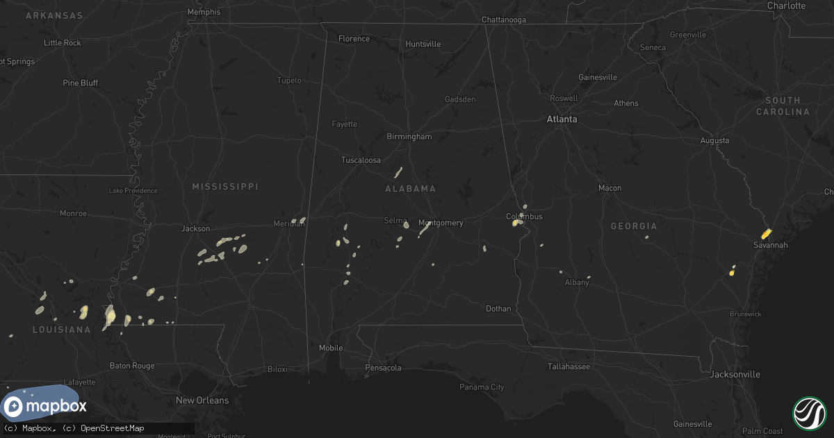
Hail Map in Alabama on May 26, 2025
Get this storm
May 26 map
$229
one time, instant access
Download today. No call, no setup
Keep the $229
Bought the map and want the full workflow? Apply the entire $229 to a subscription within 7 days. None of it is wasted.
Every map, not just this one
This buys you this map. Subscription and you get every map we run, in the markets you choose from a few cities to whole states to nationwide. Plus real-time alerts the moment a storm fires.
Contact data
Name, contact info, occupancy, even credit band for addresses in the footprint. You go from where it hit to who to call.
Become the source they trust
Unlimited branding weather history reports on demand. You already have the documented answer ready for the property owner, and you are the one who showed up with it.
Property data and RoofTrace estimates
Pull up any address you have got, its value and the exact code rules for that jurisdiction, straight from One Click Code. Then RoofTrace estimates the squares, pitch, and roof value, priced the way you price.
Storm reports in Alabama
Alabama
| Date | Description |
|---|---|
| 05/26/20256:50 PM CDT | A tree fell across western dr in montevallo. |
| 05/26/20256:32 PM CDT | Trees were downed on cr 33 near calhoun school and on highway 80. |
| 05/26/20255:55 PM CDT | A few trees were downed around dallas county... Including highway 66 at cr 1... Cr 4 at cr 85... Cr 222... Along highway 22... And along highway 41. |
| 05/26/20255:20 PM CDT | Numerous trees were reported down across marengo county. One tree fell on power lines in demopolis. |
| 05/26/20254:52 PM CDT | Several trees fell around southwestern sumter county. One tree fell on power lines at cr 10 and siloam rd. |
| 05/25/20257:12 PM CDT | Trees were downed along highway 17 at butler rd in maylene... Dunwar st in calera... And goodwin st and industrial pkwy in columbiana. |
All States Impacted by Hail Map on May 26, 2025
Cities Impacted by Hail Map on May 26, 2025
- Lampasas, TX
- Minden, LA
- Gibsland, LA
- Homer, LA
- Doyline, LA
- Barksdale Afb, LA
- Bossier City, LA
- Waskom, TX
- Shreveport, LA
- Marshall, TX
- Greenwood, LA
- Benton, LA
- Haughton, LA
- Elm Grove, LA
- Karnack, TX
- Keithville, LA
- Haynesville, LA
- Cotton Valley, LA
- Elmer, LA
- Colfax, LA
- Boyce, LA
- Pineville, LA
- Dry Prong, LA
- Woodworth, LA
- Deridder, LA
- Trout, LA
- Jena, LA
- Palo Pinto, TX
- Graford, TX
- Lecompte, LA
- Marksville, LA
- Jonesville, LA
- Mansura, LA
- Moreauville, LA
- Woodville, MS
- May, TX
- Monterey, LA
- Carbon, TX
- McGregor, TX
- Rising Star, TX
- Comanche, TX
- Gordon, TX
- Angola, LA
- Cisco, TX
- Stephenville, TX
- Eastland, TX
- Gorman, TX
- Fayette, MS
- Natchez, MS
- Ranger, TX
- De Leon, TX
- Desdemona, TX
- Breckenridge, TX
- Santo, TX
- Crawford, TX
- Mineral Wells, TX
- Moran, TX
- Saint Francisville, LA
- Centreville, MS
- Meadville, MS
- Bude, MS
- Caddo, TX
- Lumpkin, GA
- Smithdale, MS
- Liberty, MS
- Weatherford, TX
- Richland, GA
- San Angelo, TX
- Mendenhall, MS
- Summit, MS
- Bogue Chitto, MS
- Pampa, TX
- Morton, MS
- Brandon, MS
- Osyka, MS
- Westcliffe, CO
- Graham, TX
- Pine, CO
- Weston, CO
- Christoval, TX
- Millsap, TX
- Mobeetie, TX
- Bailey, CO
- Pinola, MS
- Newhebron, MS
- Harrisville, MS
- Florence, MS
- Braxton, MS
- Los Alamos, NM
- Jemez Springs, NM
- Vancourt, TX
- Pulaski, MS
- Raleigh, MS
- Forest, MS
- Magee, MS
- Santa Fe, NM
- Garden City, TX
- Eden, TX
- Lipan, TX
- Chauncey, GA
- Dawson, GA
- Louin, MS
- Menard, TX
- Thomasville, AL
- Eastman, GA
- Las Vegas, NM
- Montezuma, NM
- Junction, TX
- Eldorado, TX
- Sterling City, TX
- Trinidad, CO
- Sweet Water, AL
- Laurel, MS
- Stringer, MS
- Moriarty, NM
- Heidelberg, MS
- Mertzon, TX
- Big Lake, TX
- Loxahatchee, FL
- Raton, NM
- Reydon, OK
- South Bend, TX
- Walsenburg, CO
- Rye, CO
- Pecos, NM
- Hext, TX
- Melvin, TX
- Brady, TX
- Strasburg, CO
- Corona, NM
- Port Wentworth, GA
- Albany, GA
- Sylvester, GA
- Cheyenne, OK
- Trinchera, CO
- Colorado City, CO
- Clewiston, FL
- Linden, AL
- Dixons Mills, AL
- Joshua, TX
- Meridian, MS
- Pine Hill, AL
- Toomsuba, MS
- Bay Springs, MS
- Grove Hill, AL
- Oakfield, GA
- Mason, TX
- Carlsbad, TX
- Ludowici, GA
- Jacksboro, TX
- South Bay, FL
- London, TX
- Stratford, TX
- Arlington, AL
- Gruver, TX
- Trementina, NM
- Cleburne, TX
- Palm Bay, FL
- Hayneville, AL
- Lowndesboro, AL
- Hardeeville, SC
- Sonora, TX
- Commerce City, CO
- Watkins, CO
- Godley, TX
- Bowie, TX
- Jackson, AL
- Ormond Beach, FL
- Crowley, TX
- Burleson, TX
- Tucumcari, NM
- Nunn, CO
- Prattville, AL
- Skellytown, TX
- New Smyrna Beach, FL
- Rocksprings, TX
- Deland, FL
- Orlando, FL
- Melbourne, FL
- Geneva, FL
- Montgomery, AL
- Granbury, TX
- Eola, TX
- Fort Worth, TX
- Pierce, CO
- Goodfellow Afb, TX
- Seale, AL
- Miami, TX
- Doss, TX
- Mansfield, TX
- Canadian, TX
- San Saba, TX
- Wall, TX
- Minter, AL
- Arlington, TX
- Kennedale, TX
- Sardis, AL
- Conchas Dam, NM
- Perryton, TX
- Booker, TX
- White Deer, TX
- Borger, TX
- Mcalister, NM
- Llano, TX
- Fredericksburg, TX
- Harper, TX
- Hinesville, GA
- Midway, AL
- Union Springs, AL
- Paint Rock, TX
- Phenix City, AL
- Fort Mitchell, AL
- Pontotoc, TX
- Allenhurst, GA
- Tyler, AL
- Capitan, NM
- Centreville, AL
- Higgins, TX
- Evant, TX
- Osteen, FL
- Cherokee, TX
- China Spring, TX
- Castell, TX
- Willow City, TX
- Groom, TX
- Grady, NM
- Aquilla, TX
- Montevallo, AL
- Brierfield, AL
- Jesup, GA
- Waco, TX
- Bridgeport, TX
- Brownwood, TX
- Brookesmith, TX
- Fort McKavett, TX
- Del Rio, TX
- Broadview, NM
- Chico, TX
- Picacho, NM
- Waynesboro, MS
- West, TX
- Columbus, GA
- Fortson, GA
- Honoraville, AL
- Lipscomb, TX
- Follett, TX
- Horseshoe Bay, TX
- Round Mountain, TX
- Johnson City, TX
- Clarendon, TX
- Stonewall, TX
- Blanco, TX
- Hye, TX
- Boerne, TX
- Abbott, TX
- Comfort, TX
- Amistad, NM
- Roswell, NM
- Shamrock, TX
- San Jon, NM
- Kerrville, TX
- Kempner, TX
- Covington, TX
- Grandview, TX
- Arnett, OK
- Shattuck, OK
- Platteville, CO
- Clovis, NM
- Logan, NM
- Adrian, TX
- Bard, NM
- Hamilton, TX
- Durham, OK
- Center Point, TX
- Alvarado, TX
- Crawford, OK
- Wheeler, TX
- Sweetwater, OK
- Leedey, OK
- Pine Apple, AL
- Pipe Creek, TX
- Rutledge, AL
- Briggs, TX
- Hereford, TX
- Spicewood, TX
- Kendalia, TX
- Marble Falls, TX
- Dripping Springs, TX
- Leander, TX
- Austin, TX
- Wimberley, TX
- Bulverde, TX
- Bergheim, TX
- Spring Branch, TX
- Fischer, TX
- Bluffton, TX
- Tow, TX
- Kingsland, TX
- Buchanan Dam, TX
- Burnet, TX
- Bertram, TX
- Killeen, TX
- Liberty Hill, TX
- Florence, TX
- Vega, TX
- Tatum, NM
- Hedley, TX
- Copperas Cove, TX
- Lelia Lake, TX
- Lometa, TX
- Sharon, OK
- Helotes, TX
- Mico, TX
- Taloga, OK
- Wildorado, TX
- Fort Washakie, WY
- Lakeview, TX
- Morton, TX
- Bandera, TX
- Amarillo, TX
- Canyon, TX
- Memphis, TX
- Hammon, OK
- San Antonio, TX
- Mutual, OK
- Selma, AL
- San Marcos, TX
- Driftwood, TX
- Salado, TX
- Georgetown, TX
- Harker Heights, TX
- Belton, TX
- Jarrell, TX
- Temple, TX
- Thorndale, TX
- Bartlett, TX
- Round Rock, TX
- Hutto, TX
- Taylor, TX
- Holland, TX
- Little River Academy, TX
- Thrall, TX
- Granger, TX
- Canyon Lake, TX
- Buda, TX
- Manchaca, TX
- Del Valle, TX
- Kyle, TX
- New Braunfels, TX
- Dale, TX
- Martindale, TX
- Cedar Creek, TX
- Maxwell, TX
- Red Rock, TX
- Lockhart, TX
- Rio Medina, TX
- Hondo, TX
- D Hanis, TX
- Leakey, TX
- Summerfield, TX
- Dimmitt, TX
- Friona, TX
- Masterson, TX
- Happy, TX
- Butler, OK
- Briscoe, TX
- Lovington, NM
- Vici, OK
- Camargo, OK
- Eagle Pass, TX
- Putnam, OK
- Childress, TX
- Barksdale, TX
- Plains, TX
- Hunt, TX
- Mountain Home, TX
- Carrizo Springs, TX
- Camp Wood, TX
- Seguin, TX
- Kingsbury, TX
- Tokio, TX
- Olton, TX
- Plainview, TX
- Hart, TX
- Custer City, OK
- Clinton, OK
- Hobbs, NM
- Medina, TX
- Brownfield, TX
- Uvalde, TX
- Hale Center, TX
- Fay, OK
- Oakwood, OK
- Thomas, OK
- Panhandle, TX
- Claude, TX
- Seagraves, TX
- Seminole, TX
- Sayre, OK
- Concan, TX
- Rincon, GA
- Sabinal, TX
- Brackettville, TX
- Elk City, OK
- La Pryor, TX
- Crystal City, TX
- Welch, TX
- Watonga, OK
- Buckholts, TX
- Cameron, TX
- Rosebud, TX
- Burlington, TX
- Rockdale, TX
- Davilla, TX
- Rogers, TX
- Milano, TX
- Caldwell, TX
- Calvert, TX
- Gause, TX
- Rosanky, TX
- Luling, TX
- Waelder, TX
- Cibolo, TX
- Harwood, TX
- Schertz, TX
- Marion, TX
- Flatonia, TX
- McQueeney, TX
- Gonzales, TX
- Jbsa Randolph, TX
- Universal City, TX
- La Vernia, TX
- Wrightsboro, TX
- Jbsa Ft Sam Houston, TX
- Converse, TX
- Cost, TX
- Nixon, TX
- Leesville, TX
- Saint Hedwig, TX
- Stockdale, TX
- Adkins, TX
- Sutherland Springs, TX
- Smiley, TX
- Floresville, TX
- Jbsa Lackland, TX
- Falls City, TX
- Elmendorf, TX
- Natalia, TX
- Poteet, TX
- Moore, TX
- Bigfoot, TX
- Atascosa, TX
- Von Ormy, TX
- Somerset, TX
- Lytle, TX
- Pleasanton, TX
- La Coste, TX
- Devine, TX
- Castroville, TX
- Batesville, TX
- Mount Enterprise, TX
- Long Branch, TX
- Abernathy, TX
- Foss, OK
- Corn, OK
- Canute, OK
- Geary, OK
- Bessie, OK
- Yancey, TX
- Greenfield, OK
- Lubbock, TX
- Cordell, OK
- Jourdanton, TX
- Charlotte, TX
- Hearne, TX
- Franklin, TX
- Bryan, TX
- Madisonville, TX
- Normangee, TX
- Iola, TX
- Bedias, TX
- North Zulch, TX
- College Station, TX
- Anderson, TX
- Calumet, OK
- Colony, OK
- Groveton, TX
- Pearsall, TX
- Okarche, OK
- El Reno, OK
- Hydro, OK
- Carnegie, OK
- Oglesby, TX
- Cresson, TX
- Pennington, TX
- Apple Springs, TX
- Hillsboro, TX
- Perrin, TX
- Mclean, TX
- Three Rivers, TX
- Christine, TX
- Calliham, TX
- Campbellton, TX
- Whitsett, TX
- Tilden, TX
- Porter, TX
- Corrigan, TX
- Diboll, TX
- Coldspring, TX
- Shepherd, TX
- Livingston, TX
- Brenham, TX
- Navasota, TX
- Washington, TX
- Somerville, TX
- Richards, TX
- Huntsville, TX
- Montgomery, TX
- Hockley, TX
- Plantersville, TX
- Prairie View, TX
- Hempstead, TX
- Waller, TX
- Bellville, TX
- Chappell Hill, TX
- Cat Spring, TX
- Magnolia, TX
- Sealy, TX
- New Waverly, TX
- Bleiblerville, TX
- Brookshire, TX
- Katy, TX
- Conroe, TX
- Pinehurst, TX
- Willis, TX
- Spring, TX
- Cypress, TX
- Cleveland, TX
- Tomball, TX
- Houston, TX
- New Caney, TX
- Splendora, TX
- Dayton, TX
- Humble, TX
- Sugar Land, TX
- Kingwood, TX
- Fulshear, TX
- Rosenberg, TX
- Richmond, TX
- Stafford, TX
- Wallis, TX
- Fort Cobb, OK
- Dill City, OK
- Mountain View, OK
- Sentinel, OK
- Gotebo, OK
- Gracemont, OK
- Anadarko, OK
- Apache, OK
- Goodrich, TX
- Lufkin, TX
- Quemado, TX
- Huntington, TX
- Cyril, OK
- Huffman, TX
- Bellaire, TX
- Crosby, TX
- Liberty, TX
- Channelview, TX
- Pasadena, TX
- Highlands, TX
- Missouri City, TX
- Galena Park, TX
- Baytown, TX
- Fresno, TX
- La Porte, TX
- Deer Park, TX
- South Houston, TX
- Webster, TX
- Pearland, TX
- Kemah, TX
- Friendswood, TX
- League City, TX
- Rosharon, TX
- Seabrook, TX
- Manvel, TX
- Alvin, TX
- Cement, OK
- Weatherford, OK
- Warren, TX
- Woodville, TX
- Big Wells, TX
- Hull, TX
- Batson, TX
- Sour Lake, TX
- Hillister, TX
- Anahuac, TX
- Asherton, TX
- Jasper, TX
- Beaumont, TX
- Catarina, TX
- Vinton, LA
- Starks, LA
- Burkeville, TX
- Sulphur, LA
- Leesville, LA
- Evans, LA
- Lake Charles, LA
- Lake Arthur, LA
- Bell City, LA
- Alexandria, LA
- Mize, MS
- Taylorsville, MS
- Welsh, LA
- Crowley, LA
- Duson, LA
- Youngsville, LA
- Erath, LA
- Grand Chenier, LA
- Gueydan, LA
- Lacassine, LA
- Morse, LA
- Maurice, LA
- Iowa, LA
- Creole, LA
- Cameron, LA
- Jennings, LA
- Estherwood, LA
- Rayne, LA
- Abbeville, LA
- Kaplan, LA


