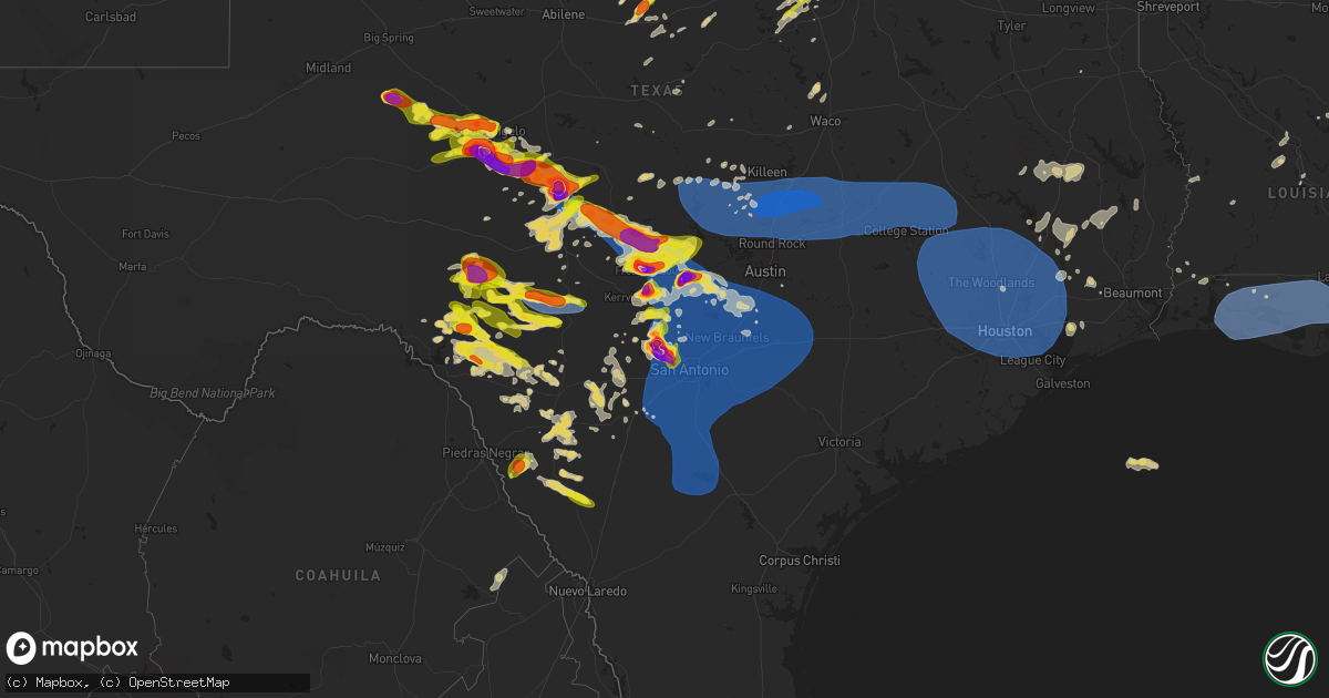
Hail Map on May 26, 2025
Get this storm
May 26 map
$229
one time, instant access
Download today. No call, no setup
Keep the $229
Bought the map and want the full workflow? Apply the entire $229 to a subscription within 7 days. None of it is wasted.
Every map, not just this one
This buys you this map. Subscription and you get every map we run, in the markets you choose from a few cities to whole states to nationwide. Plus real-time alerts the moment a storm fires.
Contact data
Name, contact info, occupancy, even credit band for addresses in the footprint. You go from where it hit to who to call.
Become the source they trust
Unlimited branding weather history reports on demand. You already have the documented answer ready for the property owner, and you are the one who showed up with it.
Property data and RoofTrace estimates
Pull up any address you have got, its value and the exact code rules for that jurisdiction, straight from One Click Code. Then RoofTrace estimates the squares, pitch, and roof value, priced the way you price.
States Impacted by Hail Map on May 26, 2025
Storm reports
Mississippi
| Date | Description |
|---|---|
| 05/26/20254:32 PM CDT | Trees and lines down... Damage path noted from ne parts of meridian to marion to near dalewood shore lake. |
| 05/26/20254:31 PM CDT | Tree downed along ms hwy 496 about four miles east of hwy 19... Report via social media. |
| 05/26/20254:31 PM CDT | Tree downed along ms hwy 496 about four miles east of hwy 19... Report via social med |
| 05/26/20254:26 PM CDT | Tree downed along 43rd st... Report via social media. |
| 05/26/20254:25 PM CDT | Tree downed partially blocking the road on country club dr near ashland ave... Report via social media. |
| 05/26/20254:23 PM CDT | Tree downed blocking causeyville rd near buckatunna creek... Report via social media. |
| 05/26/20254:21 PM CDT | Tree down partially blocking fisher rd... Report via social media. |
| 05/26/20254:16 PM CDT | Trees down on cr 470... Report via social media. |
| 05/26/20254:15 PM CDT | Tree down across the road on luther walker rd near walker bottom rd... Report via social media. |
| 05/26/20254:14 PM CDT | Large tree down at southern hills south. |
| 05/26/20254:11 PM CDT | Tre |
| 05/26/20254:11 PM CDT | Trees down on cr 350... Report via social media. |
| 05/26/20254:10 PM CDT | Numerous trees downed across northwestern clarke co from us 11 north of enterprise and including cr 3771... Cr 358... Cr 359... And cr 350 near clarkdale school. Possib |
| 05/26/20254:04 PM CDT | Several trees down on point wanita lake rd... Report via social media. |
| 05/26/20254:03 PM CDT | Multiple tree down along us 11 near cr 333 and cr 331. |
| 05/26/20254:00 PM CDT | Trees down on ms hwy 513 near rose hill... Report via social media. |
| 05/26/20253:58 PM CDT | Trees downed... Report via social media. |
| 05/26/20253:43 PM CDT | Tree down at ms hwy 590 and monroe rd... With a car crash into the tree. Multiple additional downed trees in jones county. |
| 05/26/20253:39 PM CDT | Tree downed on cr 21 near cr 10... Report via social media. |
| 05/26/20253:35 PM CDT | Tree downed on old hwy 24 at duval stuart rd. |
| 05/26/20253:30 PM CDT | Trees down along hwy 28. |
| 05/26/20253:26 PM CDT | Powerline downed at ms hwy 589 and front ave. |
| 05/26/20253:23 PM CDT | Tree down at rocky branch rd and mill creek loop. |
| 05/26/20253:14 PM CDT | Several trees down across roads. |
| 05/26/20253:12 PM CDT | Trees and a few power lines down in the sw/s part of the county. |
| 05/26/20253:12 PM CDT | Trees downed on powerlines on justin dr. |
| 05/26/20253:04 PM CDT | A couple trees downed on haynes chapel rd. Tds present on radar at the time. |
| 05/26/20253:02 PM CDT | Several trees down blocking roads. |
| 05/26/20253:01 PM CDT | This brief weak tornado started just west of haynes chapel road and ended just after crossing lake road. A tds was noted on radar and several trees were uprooted or sna |
| 05/26/20252:50 PM CDT | Tree downed along hebron hill rd. |
| 05/26/20252:45 PM CDT | Several trees and power lines down. 4 homes had trees down on them. |
| 05/26/20252:36 PM CDT | Tree downed on 1st st. |
| 05/26/20252:33 PM CDT | Several trees down and power lines down. |
| 05/26/20252:31 PM CDT | Tree downed on triple pine cir. |
| 05/26/20252:29 PM CDT | Tree downed on pin oak st. |
| 05/26/20252:15 PM CDT | Numerous trees and powerlines downed across the southern portions of the county. |
| 05/26/20252:15 PM CDT | Tree down on stubbs rd near green gable rd. |
| 05/26/20252:14 PM CDT | Tree downed on power lines around the intersection of midway rd and midway estates dr. |
| 05/26/20252:13 PM CDT | Power lines downed resulting in power outages in downtown brookhaven. |
| 05/26/20252:09 PM CDT | Tree downed on the road on lebanon pine grove rd near prentiss crump rd. |
| 05/26/20252:05 PM CDT | Tree downed across port gibson st. |
| 05/26/20252:04 PM CDT | Power lines downed on dry grove rd near cedar ridge rd. |
| 05/26/20252:03 PM CDT | Tree down across dry grove rd near ms hwy 18. |
| 05/26/20252:00 PM CDT | Tree downed on the road at carolyn dr and pauline dr. |
| 05/26/20251:53 PM CDT | Trees and lines down across the se part of the county. |
| 05/26/20251:50 PM CDT | Trees down and one on a home. |
| 05/26/20251:15 PM CDT | Several trees down across the s part of the county. |
| 05/26/202512:56 PM CDT | Multiple trees downed along spokane rd... Blocking the road. |
| 05/26/202512:55 PM CDT | Trees downed on rice rd and artman rd. |
| 05/26/202512:54 PM CDT | Tree fell on a vehicle along pinemount. |
| 05/26/202512:52 PM CDT | Sporadic downed trees around adams county. |
| 05/26/20258:20 AM CDT | Tree downed on residence as well as multiple trees downed around the area. |
| 05/26/20256:50 AM CDT | A few trees down. |
| 05/26/20256:50 AM CDT | Mul |
| 05/26/20256:50 AM CDT | Multiple trees down and down across roads... S part of county. |
| 05/26/20256:50 AM CDT | A few trees down. |
| 05/26/20256:50 AM CDT | Mu |
| 05/26/20256:32 AM CDT | A few trees down acro |
| 05/26/20256:32 AM CDT | A few t |
| 05/26/20256:32 AM CDT | A few trees down across the e side of the county. |
| 05/26/20256:20 AM CDT | Scattered trees down around natchez. One tree down on a home... Another tree down on 3 vehicles... Another tree down on a comms trailer. |
Alabama
| Date | Description |
|---|---|
| 05/26/20256:50 PM CDT | A tree fell across western dr in montevallo. |
| 05/26/20256:32 PM CDT | Trees were downed on cr 33 near calhoun school and on highway 80. |
| 05/26/20255:55 PM CDT | A few trees were downed around dallas county... Including highway 66 at cr 1... Cr 4 at cr 85... Cr 222... Along highway 22... And along highway 41. |
| 05/26/20255:20 PM CDT | Numerous trees were reported down across marengo county. One tree fell on power lines in demopolis. |
| 05/26/20254:52 PM CDT | Several trees fell around southwestern sumter county. One tree fell on power lines at cr 10 and siloam rd. |
| 05/25/20257:12 PM CDT | Trees were downed along highway 17 at butler rd in maylene... Dunwar st in calera... And goodwin st and industrial pkwy in columbiana. |
Colorado
| Date | Description |
|---|---|
| 05/26/20252:53 PM CDT | Asos station kdro durango la plata cnty airport. |
Georgia
| Date | Description |
|---|---|
| 05/26/20255:01 PM CDT | Social media report indicated at least golfball sized hail on the se side of ludowici... Ga. Time estimated using radar data. |
| 05/26/20254:45 PM CDT | Public reported ping pong ball size hail near highway 21 at old augusta road. |
| 05/26/20254:28 PM CDT | A picture was received on x showing a portion of the roof of a church off augusta road peeled off. Time estimated based on radar. |
| 05/26/20254:28 PM CDT | Images of several trees belown down along augusta road were received via social media. Time estimated based on radar. |
| 05/26/20254:25 PM CDT | Social media video showed large hail along with strong winds in the port wentworth area. In the video... A blown trampoline is resting against a house. Time estimated u |
| 05/26/20254:25 PM CDT | Social media pictures show damage to a gas station awning. Traffic signals were down in the intersection of augusta road and old richmond road. Trees reported down in t |
| 05/26/20254:25 PM CDT | Social media picture showed a tree down across a tractor trailer on highway 21 near highway 30. |
| 05/26/20254:22 PM CDT | A tree fell down on two houses on treadway street. Time estimated by radar. |
| 05/26/20254:22 PM CDT | Tree down on a house on treadway street. Time estimated by radar. |
Texas
| Date | Description |
|---|---|
| 05/26/20256:50 PM CDT | Corrects a previous report of location and hail in groom. 2 to 2.5 inch hail fell at this location. |
| 05/26/20256:50 PM CDT | A local report indicates 2.50 inch wind near Groom |
| 05/26/20256:40 PM CDT | Hail up to quarter sized occurred along county road x. |
| 05/26/20256:29 PM CDT | A local report indicates 2.00 inch wind near 3 NW Loyal Valley |
| 05/26/20256:25 PM CDT | The public reported multiple snapped power poles along with 3.25 inch hail. |
| 05/26/20256:13 PM CDT | A trained spotter reported 3 to 3.5 inch hail. |
| 05/26/20256:08 PM CDT | The public reported ping pong to baseball size hail. |
| 05/26/20256:03 PM CDT | Report from mping: golf ball |
| 05/26/20256:03 PM CDT | A local report indicates 2.75 inch wind near 1 N Christoval |
| 05/26/20256:00 PM CDT | Report from mping: quarter |
| 05/26/20256:00 PM CDT | A spotter measured 3.75 inch hail. |
| 05/26/20255:57 PM CDT | Report from mping: baseball++ |
| 05/26/20255:53 PM CDT | Report from mping. |
| 05/26/20255:47 PM CDT | Report from mping: quarter |
| 05/26/20255:46 PM CDT | Report from mping: quarter |
| 05/26/20255:46 PM CDT | Report from mping. |
| 05/26/20255:43 PM CDT | A local report indicates 1.00 inch wind near 2 E Tankersley |
| 05/26/20255:38 PM CDT | A local report indicates 1.25 inch wind near 3 W Tankersley |
| 05/26/20255:37 PM CDT | A local report indicates 1.00 inch wind near 2 NNE San Angelo |
| 05/26/20255:33 PM CDT | Report from mping: ping pong ball |
| 05/26/20255:28 PM CDT | Report from mping: quarter |
| 05/26/20255:22 PM CDT | Report from mping: quarter |
| 05/26/20255:21 PM CDT | A local report indicates 1.00 inch wind near Godley |
| 05/26/20255:20 PM CDT | A local report indicates 1.75 inch wind near 5 S Grape Creek |
| 05/26/20254:23 PM CDT | A storm chaser posted pictures on social media and indicated that they measured hail stones between 5.51 to 5.90 inches. |
| 05/26/20254:23 PM CDT | Corrects previous hail report from 1 wnw menard. Icechip. A storm chaser posted pictures on social media and indicated that they measured hail stones between 5.51 to 5. |
| 05/26/20254:22 PM CDT | Report from mping: half dollar |
| 05/26/20254:20 PM CDT | A local report indicates 1.50 inch wind near 1 S Tankersley |
| 05/26/20254:15 PM CDT | Report from mping: baseball+ |
| 05/26/20254:13 PM CDT | A trained |
| 05/26/20254:13 PM CDT | A trained spotter reported a tornado just southwest of menard. |
| 05/26/20254:12 PM CDT | A local report indicates 73 MPH wind near 2 WNW Menard |
| 05/26/20254:03 PM CDT | Report from mping: quarter |
| 05/26/20253:50 PM CDT | The report was received through social media. |
| 05/26/20253:42 PM CDT | Golf ball sized hail reported a few miles southeast of garden city. Occasionally larger hail stones observed... But infrequent. |
| 05/26/20253:27 PM CDT | Report from mping: golf ball |
| 05/26/20253:24 PM CDT | Report of hen egg sized hail near rm 33... South of garden city. |
| 05/26/20252:17 PM CDT | A local report indicates 1.50 inch wind near 8 NNE Christoval |
| 05/26/20251:53 PM CDT | Report from mping. |
| 05/26/20251:14 PM CDT | Report from mping. |
| 05/26/20251:10 PM CDT | Report from mping. |
| 05/26/20258:25 AM CDT | Reports of several water rescues under railroad bridges at green st and nelson st...green st. And cotton st....and high st. And cotton st. In longview. Also... Several |
| 05/26/20253:56 AM CDT | Awos station kngp c. Christi nas. |
| 05/26/20253:51 AM CDT | Tree down across hickory hill dr. |
| 05/26/20253:30 AM CDT | Reports of multiple trees down across burkeville... Tx. |
| 05/26/20253:17 AM CDT | Reports of multiple trees down across newton... Tx. |
| 05/26/20252:30 AM CDT | Corrects previous tstm wnd dmg report from burkeville. Reports of multiple trees down across burkeville... Tx. |
| 05/26/20251:37 AM CDT | Trees down across old silsbee road. |
| 05/26/20251:36 AM CDT | Tree blown down. |
| 05/26/202512:52 AM CDT | Multiple trees down across fm 1014 near rockland... Tx. |
| 05/26/202512:48 AM CDT | Mesonet station lhft2 lake houston at fm 1960. |
| 05/26/202512:30 AM CDT | Trees blown down. |
| 05/26/202512:26 AM CDT | Asos station kiah houston intnl. |
| 05/26/202512:24 AM CDT | Tree blown down onto a home. |
| 05/26/202512:15 AM CDT | A trained storm spotter shared photos on social media of snapped tree branches near college park... South of conroe. Wind speeds were estimated at 75 mph using softwood |
| 05/26/202512:15 AM CDT | Large tree down. |
| 05/26/202512:09 AM CDT | A trained storm spotter estimated wind gusts up to 60 mph in spring. |
| 05/26/202512:06 AM CDT | Trees and branches down. |
| 05/26/202512:05 AM CDT | Broadcast media reported damage to a restaurant in conroe after a line of thunderstorms pushed through the area. Photos shared by the restaurant on social media show pa |
| 05/26/202512:00 AM CDT | Trees and powerlines down. |
| 05/25/202510:25 PM CDT | A local report indicates 1.25 inch wind near 7 SE Brownfield |
| 05/25/202510:15 PM CDT | A local report indicates 1.75 inch wind near 6 SW Brownfield |
| 05/25/20259:59 PM CDT | Report from mping. (ew |
| 05/25/20259:59 PM CDT | Report from mping. |
| 05/25/20259:57 PM CDT | Report from mping. |
| 05/25/20259:56 PM CDT | Report from mping. |
| 05/25/20259:49 PM CDT | Report from mping. |
| 05/25/20259:45 PM CDT | A local report indicates 2.50 inch wind near 1 ESE San Geronimo |
| 05/25/20259:45 PM CDT | Corrects previous hail report size from 1 ese san geronimo. Picture received from media of grapefruit sized hail near bandera road and tx-211. |
| 05/25/20259:44 PM CDT | A local report indicates 1.00 inch wind near Helotes |
| 05/25/20259:43 PM CDT | Golf ball hail reported by trained spotter near circle s drive. |
| 05/25/20259:43 PM CDT | Golf ball hail reported by trained spotter near circle s |
| 05/25/20259:30 PM CDT | Yoakum so reports power outages in plains due to thunderstorm winds. |
| 05/25/20259:22 PM CDT | Hail of at least quarter size fell near circle c trail and claude highway. Window and gutter damage occurred as well as some vehicle damage. Report came via social medi |
| 05/25/20259:20 PM CDT | A local report indicates 1.25 inch wind near 4 N Lake Tanglewood |
| 05/25/20259:17 PM CDT | 3 in hailstone measured from culebra and talley rd. Time estimated via radar. |
| 05/25/20259:15 PM CDT | A local report indicates 1.25 inch wind near 3 NNW Timbercreek Canyo |
| 05/25/20259:15 PM CDT | A local report indicates 60 MPH wind near Rogers |
| 05/25/20259:12 PM CDT | Quarter sized hail reported. |
| 05/25/20259:05 PM CDT | Mesonet station tw101 camp eagle. |
| 05/25/20259:05 PM CDT | Delayed report. Texas mesonet station measured a 66 mph gust just south of stillhouse hollow lake. |
| 05/25/20259:03 PM CDT | Trees down and parts of a deck ripped off. |
| 05/25/20258:58 PM CDT | Estimated 80 mph wind gust. |
| 05/25/20258:55 PM CDT | Memphis pd reports hail slightly larger than quarters in town. |
| 05/25/20258:55 PM CDT | Memphis pd reports |
| 05/25/20258:54 PM CDT | Winds gusting between 59 and 68 mph between 2054cdt and 2059cdt. |
| 05/25/20258:53 PM CDT | Tree damage reported. |
| 05/25/20258:52 PM CDT | A local report indicates 1.00 inch wind near 7 S Clarendon |
| 05/25/20258:45 PM CDT | Widespread downed trees and power outages reported in san marcos. |
| 05/25/20258:43 PM CDT | A local report indicates 66 MPH wind near 4 E Vega |
| 05/25/20258:43 PM CDT | ( |
| 05/25/20258:40 PM CDT | Fencing and traffic signage blown down. Time estimated via radar. |
| 05/25/20258:34 PM CDT | 60 mph gust measured by handheld anemometer at 834pm. |
| 05/25/20258:28 PM CDT | Report from mping: quarter |
| 05/25/20258:14 PM CDT | Time estimated from radar. |
| 05/25/20258:11 PM CDT | Quarter to golfball sized hail fell on the north side of howardwick. |
| 05/25/20257:54 PM CDT | Quarter size hail reported at i10 at big joshua creek. |
| 05/25/20257:53 PM CDT | 50kt gust reported at kbmq at 0053z. |
| 05/25/20257:53 PM CDT | 50kt gust reported at kbmq at 0053z. |
| 05/25/20257:43 PM CDT | Hail also broke windows. |
| 05/25/20257:31 PM CDT | Report from mping. |
| 05/25/20257:30 PM CDT | Report from mping. |
| 05/25/20257:29 PM CDT | Report from mping. |
| 05/25/20257:25 PM CDT | Report from mping. |
| 05/25/20257:25 PM CDT | A local report indicates 2.50 inch wind near 8 NNW Comfort |
| 05/25/20257:22 PM CDT | A local report indicates 2.75 inch wind near 1 S Hye |
| 05/25/20257:18 PM CDT | Report from mping. |
| 05/25/20257:16 PM CDT | Report from mping. |
| 05/25/20257:12 PM CDT | Golf ball sized hail reported in downtown fredericksburg. |
| 05/25/20257:11 PM CDT | Report from mping: hen egg+ |
| 05/25/20257:06 PM CDT | Measured golf-ball sized hail on the nw side of fredericksburg. |
| 05/25/20257:06 PM CDT | Cocorahs report says lots of damage from baseball size hail. Time estimated from radar. |
| 05/25/20257:05 PM CDT | Picture from cocorahs of ping pong ball to golf ball size hail. |
| 05/25/20257:05 PM CDT | Report from mping: ping pong ball |
| 05/25/20257:04 PM CDT | Report from mping: |
| 05/25/20257:04 PM CDT | Report from mping: half dollar |
| 05/25/20257:04 PM CDT | Report from mping: quarter |
| 05/25/20257:00 PM CDT | Corrects time from previous hail report from 3 wnw fredericksburg. Hail also broke windows. |
New Mexico
| Date | Description |
|---|---|
| 05/26/20255:55 PM CDT | A local report indicates 1.00 inch wind near 2 N Montoya |
| 05/26/20254:29 PM CDT | Dime to quarter size hail. |
| 05/26/20254:12 PM CDT | Report from mping: quarter |
| 05/26/20254:05 PM CDT | A local report indicates 1.00 inch wind near 2 SE Edgewood |
| 05/26/20254:05 PM CDT | Corrected location for 1 inch hail report 2 miles se edgewood. |
| 05/26/20253:32 PM CDT | Report from mping: quarter |
| 05/26/20253:26 PM CDT | Viewer near san geronimo looking to the northeast observed a tornado in the distance. Lsr location and time is determined based on rotational radar derived signature. |
| 05/25/20258:40 PM CDT | Mesonet station reported a thunderstorm gust of 57 mph 2miles sw of tatum nm. |
| 05/25/20257:25 PM CDT | A local report indicates 1.00 inch wind near 7 NNE Two Rivers Dam |
| 05/25/20257:20 PM CDT | A local report indicates 1.50 inch wind near 7 N Two Rivers Dam |
| 05/25/20257:15 PM CDT | Strong and damaging winds along with some funnels along the gust front ahead of a line of storms flipped and overturned a trailer nest forrest. |
| 05/25/20257:06 PM CDT | A local report indicates 1.75 inch wind near 1 W Grady |
| 05/25/20257:01 PM CDT | Asos station ktcc tucumcari muni airport. |
Louisiana
| Date | Description |
|---|---|
| 05/26/202512:55 PM CDT | Couple trees down and many large limbs from st. Joe to around lake bruin. |
| 05/26/202512:04 PM CDT | Tree down on la hwy 3037. |
| 05/26/202512:00 PM CDT | Tree down on la hwy 923. |
| 05/26/202511:56 AM CDT | Tree down on la hwy 126. |
| 05/26/202511:34 AM CDT | Multiple trees down across the road. |
| 05/26/202511:20 AM CDT | Fire department reported trees down on a residential home. |
| 05/26/202511:20 AM CDT | Fire department reported trees fallen on power lines. Time estimated from radar. |
| 05/26/202511:16 AM CDT | Tree fell on house with 1 person trapped inside. No injuries reported. |
| 05/26/202511:13 AM CDT | Trees down across road. |
| 05/26/202511:09 AM CDT | A thunderstorm containing damaging descending rear inflow jet winds up to 90 mph created a swath of damage across northern rapides parish on may 26th 2025. Damage exten |
| 05/26/202511:06 AM CDT | Tree across road at 465 irving long rd. |
| 05/26/202511:04 AM CDT | Two trees down. |
| 05/26/20255:55 AM CDT | A few trees and large limbs down in the s part of the parish... Some power out. (jan |
| 05/26/20255:55 AM CDT | A few trees and large limbs down in the s part of the parish... Some power out. |
| 05/26/20255:55 AM CDT | Report of a tree down in fordoche. |
| 05/26/20254:58 AM CDT | Tree down across nursing home road about 1 mile east of us-71. |
| 05/26/20254:58 AM CDT | Tree down across nursing home road about 1 mile east of us-71. ( |
| 05/26/20254:40 AM CDT | Reports of a tree down south of pine prairie. |
| 05/26/20254:37 AM CDT | Tree down across road near ruby... La. |
| 05/26/20254:16 AM CDT | Multiple trees down south of new llano near us 171. |
| 05/26/20253:59 AM CDT | Mesonet station lacl1 lacassine. |
| 05/26/20253:53 AM CDT | Asos station klch lake charles. |
| 05/26/20253:45 AM CDT | Tree fell across freeland rd. |
| 05/26/20253:20 AM CDT | Corrects previous non-tstm wnd dmg report from 3 e sulphur. Trees and power lines blown down in sulphur... La. |
| 05/26/20253:08 AM CDT | A gustnado damaged 4 rvs and destroyed 3 along with damage to utility poles. Estimated max wind speed is 80 mph. |
| 05/26/20253:07 AM CDT | Corrects previous tstm wnd gst report from 5 s lake charles. Asos station klch lake charles. |
Oklahoma
| Date | Description |
|---|---|
| 05/26/202512:10 AM CDT | A local report indicates 60 MPH wind near 3 S Alfalfa |
| 05/25/202511:40 PM CDT | Report from mping: golf ball |
| 05/25/202510:55 PM CDT | Awos station kelk elk city. |
| 05/25/202510:44 PM CDT | Corrects previous tstm wnd gst report from 2 ne elk city for time. Awos station kelk elk city. |
| 05/25/20259:41 PM CDT | A local report indicates 2.75 inch wind near 2 E Hammon |
| 05/25/20259:34 PM CDT | A local report indicates 1.75 inch wind near Hammon |
| 05/25/20259:33 PM CDT | Corrects previous hail report from hammon. Koco tv. Correct made. |
| 05/25/20259:32 PM CDT | A local report indicates 2.75 inch wind near 1 NE Hammon |
| 05/25/20259:29 PM CDT | A local report indicates 1.75 inch wind near 2 N Hammon |
| 05/25/20259:21 PM CDT | A local report indicates 1.75 inch wind near 4 NW Hammon |
| 05/25/20258:30 PM CDT | A local report indicates 2.50 inch wind near 2 E Crawford |
| 05/25/20258:25 PM CDT | A local report indicates 2.75 inch wind near Crawford |
South Carolina
| Date | Description |
|---|---|
| 05/26/20254:50 PM CDT | A storm chaser relayed a report of quarter size hail off exit 5 along i-95 in hardeeville. Time estimated based on radar. |
Idaho
| Date | Description |
|---|---|
| 05/25/20259:50 PM CDT | S-c portable #3 raws mesonet. |
Cities Impacted by Hail Map on May 26, 2025
- Lampasas, TX
- Minden, LA
- Gibsland, LA
- Homer, LA
- Doyline, LA
- Barksdale Afb, LA
- Bossier City, LA
- Waskom, TX
- Shreveport, LA
- Marshall, TX
- Greenwood, LA
- Benton, LA
- Haughton, LA
- Elm Grove, LA
- Karnack, TX
- Keithville, LA
- Haynesville, LA
- Cotton Valley, LA
- Elmer, LA
- Colfax, LA
- Boyce, LA
- Pineville, LA
- Dry Prong, LA
- Woodworth, LA
- Deridder, LA
- Trout, LA
- Jena, LA
- Palo Pinto, TX
- Graford, TX
- Lecompte, LA
- Marksville, LA
- Jonesville, LA
- Mansura, LA
- Moreauville, LA
- Woodville, MS
- May, TX
- Monterey, LA
- Carbon, TX
- McGregor, TX
- Rising Star, TX
- Comanche, TX
- Gordon, TX
- Angola, LA
- Cisco, TX
- Stephenville, TX
- Eastland, TX
- Gorman, TX
- Fayette, MS
- Natchez, MS
- Ranger, TX
- De Leon, TX
- Desdemona, TX
- Breckenridge, TX
- Santo, TX
- Crawford, TX
- Mineral Wells, TX
- Moran, TX
- Saint Francisville, LA
- Centreville, MS
- Meadville, MS
- Bude, MS
- Caddo, TX
- Lumpkin, GA
- Smithdale, MS
- Liberty, MS
- Weatherford, TX
- Richland, GA
- San Angelo, TX
- Mendenhall, MS
- Summit, MS
- Bogue Chitto, MS
- Pampa, TX
- Morton, MS
- Brandon, MS
- Osyka, MS
- Westcliffe, CO
- Graham, TX
- Pine, CO
- Weston, CO
- Christoval, TX
- Millsap, TX
- Mobeetie, TX
- Bailey, CO
- Pinola, MS
- Newhebron, MS
- Harrisville, MS
- Florence, MS
- Braxton, MS
- Los Alamos, NM
- Jemez Springs, NM
- Vancourt, TX
- Pulaski, MS
- Raleigh, MS
- Forest, MS
- Magee, MS
- Santa Fe, NM
- Garden City, TX
- Eden, TX
- Lipan, TX
- Chauncey, GA
- Dawson, GA
- Louin, MS
- Menard, TX
- Thomasville, AL
- Eastman, GA
- Las Vegas, NM
- Montezuma, NM
- Junction, TX
- Eldorado, TX
- Sterling City, TX
- Trinidad, CO
- Sweet Water, AL
- Laurel, MS
- Stringer, MS
- Moriarty, NM
- Heidelberg, MS
- Mertzon, TX
- Big Lake, TX
- Loxahatchee, FL
- Raton, NM
- Reydon, OK
- South Bend, TX
- Walsenburg, CO
- Rye, CO
- Pecos, NM
- Hext, TX
- Melvin, TX
- Brady, TX
- Strasburg, CO
- Corona, NM
- Port Wentworth, GA
- Albany, GA
- Sylvester, GA
- Cheyenne, OK
- Trinchera, CO
- Colorado City, CO
- Clewiston, FL
- Linden, AL
- Dixons Mills, AL
- Joshua, TX
- Meridian, MS
- Pine Hill, AL
- Toomsuba, MS
- Bay Springs, MS
- Grove Hill, AL
- Oakfield, GA
- Mason, TX
- Carlsbad, TX
- Ludowici, GA
- Jacksboro, TX
- South Bay, FL
- London, TX
- Stratford, TX
- Arlington, AL
- Gruver, TX
- Trementina, NM
- Cleburne, TX
- Palm Bay, FL
- Hayneville, AL
- Lowndesboro, AL
- Hardeeville, SC
- Sonora, TX
- Commerce City, CO
- Watkins, CO
- Godley, TX
- Bowie, TX
- Jackson, AL
- Ormond Beach, FL
- Crowley, TX
- Burleson, TX
- Tucumcari, NM
- Nunn, CO
- Prattville, AL
- Skellytown, TX
- New Smyrna Beach, FL
- Rocksprings, TX
- Deland, FL
- Orlando, FL
- Melbourne, FL
- Geneva, FL
- Montgomery, AL
- Granbury, TX
- Eola, TX
- Fort Worth, TX
- Pierce, CO
- Goodfellow Afb, TX
- Seale, AL
- Miami, TX
- Doss, TX
- Mansfield, TX
- Canadian, TX
- San Saba, TX
- Wall, TX
- Minter, AL
- Arlington, TX
- Kennedale, TX
- Sardis, AL
- Conchas Dam, NM
- Perryton, TX
- Booker, TX
- White Deer, TX
- Borger, TX
- Mcalister, NM
- Llano, TX
- Fredericksburg, TX
- Harper, TX
- Hinesville, GA
- Midway, AL
- Union Springs, AL
- Paint Rock, TX
- Phenix City, AL
- Fort Mitchell, AL
- Pontotoc, TX
- Allenhurst, GA
- Tyler, AL
- Capitan, NM
- Centreville, AL
- Higgins, TX
- Evant, TX
- Osteen, FL
- Cherokee, TX
- China Spring, TX
- Castell, TX
- Willow City, TX
- Groom, TX
- Grady, NM
- Aquilla, TX
- Montevallo, AL
- Brierfield, AL
- Jesup, GA
- Waco, TX
- Bridgeport, TX
- Brownwood, TX
- Brookesmith, TX
- Fort McKavett, TX
- Del Rio, TX
- Broadview, NM
- Chico, TX
- Picacho, NM
- Waynesboro, MS
- West, TX
- Columbus, GA
- Fortson, GA
- Honoraville, AL
- Lipscomb, TX
- Follett, TX
- Horseshoe Bay, TX
- Round Mountain, TX
- Johnson City, TX
- Clarendon, TX
- Stonewall, TX
- Blanco, TX
- Hye, TX
- Boerne, TX
- Abbott, TX
- Comfort, TX
- Amistad, NM
- Roswell, NM
- Shamrock, TX
- San Jon, NM
- Kerrville, TX
- Kempner, TX
- Covington, TX
- Grandview, TX
- Arnett, OK
- Shattuck, OK
- Platteville, CO
- Clovis, NM
- Logan, NM
- Adrian, TX
- Bard, NM
- Hamilton, TX
- Durham, OK
- Center Point, TX
- Alvarado, TX
- Crawford, OK
- Wheeler, TX
- Sweetwater, OK
- Leedey, OK
- Pine Apple, AL
- Pipe Creek, TX
- Rutledge, AL
- Briggs, TX
- Hereford, TX
- Spicewood, TX
- Kendalia, TX
- Marble Falls, TX
- Dripping Springs, TX
- Leander, TX
- Austin, TX
- Wimberley, TX
- Bulverde, TX
- Bergheim, TX
- Spring Branch, TX
- Fischer, TX
- Bluffton, TX
- Tow, TX
- Kingsland, TX
- Buchanan Dam, TX
- Burnet, TX
- Bertram, TX
- Killeen, TX
- Liberty Hill, TX
- Florence, TX
- Vega, TX
- Tatum, NM
- Hedley, TX
- Copperas Cove, TX
- Lelia Lake, TX
- Lometa, TX
- Sharon, OK
- Helotes, TX
- Mico, TX
- Taloga, OK
- Wildorado, TX
- Fort Washakie, WY
- Lakeview, TX
- Morton, TX
- Bandera, TX
- Amarillo, TX
- Canyon, TX
- Memphis, TX
- Hammon, OK
- San Antonio, TX
- Mutual, OK
- Selma, AL
- San Marcos, TX
- Driftwood, TX
- Salado, TX
- Georgetown, TX
- Harker Heights, TX
- Belton, TX
- Jarrell, TX
- Temple, TX
- Thorndale, TX
- Bartlett, TX
- Round Rock, TX
- Hutto, TX
- Taylor, TX
- Holland, TX
- Little River Academy, TX
- Thrall, TX
- Granger, TX
- Canyon Lake, TX
- Buda, TX
- Manchaca, TX
- Del Valle, TX
- Kyle, TX
- New Braunfels, TX
- Dale, TX
- Martindale, TX
- Cedar Creek, TX
- Maxwell, TX
- Red Rock, TX
- Lockhart, TX
- Rio Medina, TX
- Hondo, TX
- D Hanis, TX
- Leakey, TX
- Summerfield, TX
- Dimmitt, TX
- Friona, TX
- Masterson, TX
- Happy, TX
- Butler, OK
- Briscoe, TX
- Lovington, NM
- Vici, OK
- Camargo, OK
- Eagle Pass, TX
- Putnam, OK
- Childress, TX
- Barksdale, TX
- Plains, TX
- Hunt, TX
- Mountain Home, TX
- Carrizo Springs, TX
- Camp Wood, TX
- Seguin, TX
- Kingsbury, TX
- Tokio, TX
- Olton, TX
- Plainview, TX
- Hart, TX
- Custer City, OK
- Clinton, OK
- Hobbs, NM
- Medina, TX
- Brownfield, TX
- Uvalde, TX
- Hale Center, TX
- Fay, OK
- Oakwood, OK
- Thomas, OK
- Panhandle, TX
- Claude, TX
- Seagraves, TX
- Seminole, TX
- Sayre, OK
- Concan, TX
- Rincon, GA
- Sabinal, TX
- Brackettville, TX
- Elk City, OK
- La Pryor, TX
- Crystal City, TX
- Welch, TX
- Watonga, OK
- Buckholts, TX
- Cameron, TX
- Rosebud, TX
- Burlington, TX
- Rockdale, TX
- Davilla, TX
- Rogers, TX
- Milano, TX
- Caldwell, TX
- Calvert, TX
- Gause, TX
- Rosanky, TX
- Luling, TX
- Waelder, TX
- Cibolo, TX
- Harwood, TX
- Schertz, TX
- Marion, TX
- Flatonia, TX
- McQueeney, TX
- Gonzales, TX
- Jbsa Randolph, TX
- Universal City, TX
- La Vernia, TX
- Wrightsboro, TX
- Jbsa Ft Sam Houston, TX
- Converse, TX
- Cost, TX
- Nixon, TX
- Leesville, TX
- Saint Hedwig, TX
- Stockdale, TX
- Adkins, TX
- Sutherland Springs, TX
- Smiley, TX
- Floresville, TX
- Jbsa Lackland, TX
- Falls City, TX
- Elmendorf, TX
- Natalia, TX
- Poteet, TX
- Moore, TX
- Bigfoot, TX
- Atascosa, TX
- Von Ormy, TX
- Somerset, TX
- Lytle, TX
- Pleasanton, TX
- La Coste, TX
- Devine, TX
- Castroville, TX
- Batesville, TX
- Mount Enterprise, TX
- Long Branch, TX
- Abernathy, TX
- Foss, OK
- Corn, OK
- Canute, OK
- Geary, OK
- Bessie, OK
- Yancey, TX
- Greenfield, OK
- Lubbock, TX
- Cordell, OK
- Jourdanton, TX
- Charlotte, TX
- Hearne, TX
- Franklin, TX
- Bryan, TX
- Madisonville, TX
- Normangee, TX
- Iola, TX
- Bedias, TX
- North Zulch, TX
- College Station, TX
- Anderson, TX
- Calumet, OK
- Colony, OK
- Groveton, TX
- Pearsall, TX
- Okarche, OK
- El Reno, OK
- Hydro, OK
- Carnegie, OK
- Oglesby, TX
- Cresson, TX
- Pennington, TX
- Apple Springs, TX
- Hillsboro, TX
- Perrin, TX
- Mclean, TX
- Three Rivers, TX
- Christine, TX
- Calliham, TX
- Campbellton, TX
- Whitsett, TX
- Tilden, TX
- Porter, TX
- Corrigan, TX
- Diboll, TX
- Coldspring, TX
- Shepherd, TX
- Livingston, TX
- Brenham, TX
- Navasota, TX
- Washington, TX
- Somerville, TX
- Richards, TX
- Huntsville, TX
- Montgomery, TX
- Hockley, TX
- Plantersville, TX
- Prairie View, TX
- Hempstead, TX
- Waller, TX
- Bellville, TX
- Chappell Hill, TX
- Cat Spring, TX
- Magnolia, TX
- Sealy, TX
- New Waverly, TX
- Bleiblerville, TX
- Brookshire, TX
- Katy, TX
- Conroe, TX
- Pinehurst, TX
- Willis, TX
- Spring, TX
- Cypress, TX
- Cleveland, TX
- Tomball, TX
- Houston, TX
- New Caney, TX
- Splendora, TX
- Dayton, TX
- Humble, TX
- Sugar Land, TX
- Kingwood, TX
- Fulshear, TX
- Rosenberg, TX
- Richmond, TX
- Stafford, TX
- Wallis, TX
- Fort Cobb, OK
- Dill City, OK
- Mountain View, OK
- Sentinel, OK
- Gotebo, OK
- Gracemont, OK
- Anadarko, OK
- Apache, OK
- Goodrich, TX
- Lufkin, TX
- Quemado, TX
- Huntington, TX
- Cyril, OK
- Huffman, TX
- Bellaire, TX
- Crosby, TX
- Liberty, TX
- Channelview, TX
- Pasadena, TX
- Highlands, TX
- Missouri City, TX
- Galena Park, TX
- Baytown, TX
- Fresno, TX
- La Porte, TX
- Deer Park, TX
- South Houston, TX
- Webster, TX
- Pearland, TX
- Kemah, TX
- Friendswood, TX
- League City, TX
- Rosharon, TX
- Seabrook, TX
- Manvel, TX
- Alvin, TX
- Cement, OK
- Weatherford, OK
- Warren, TX
- Woodville, TX
- Big Wells, TX
- Hull, TX
- Batson, TX
- Sour Lake, TX
- Hillister, TX
- Anahuac, TX
- Asherton, TX
- Jasper, TX
- Beaumont, TX
- Catarina, TX
- Vinton, LA
- Starks, LA
- Burkeville, TX
- Sulphur, LA
- Leesville, LA
- Evans, LA
- Lake Charles, LA
- Lake Arthur, LA
- Bell City, LA
- Alexandria, LA
- Mize, MS
- Taylorsville, MS
- Welsh, LA
- Crowley, LA
- Duson, LA
- Youngsville, LA
- Erath, LA
- Grand Chenier, LA
- Gueydan, LA
- Lacassine, LA
- Morse, LA
- Maurice, LA
- Iowa, LA
- Creole, LA
- Cameron, LA
- Jennings, LA
- Estherwood, LA
- Rayne, LA
- Abbeville, LA
- Kaplan, LA