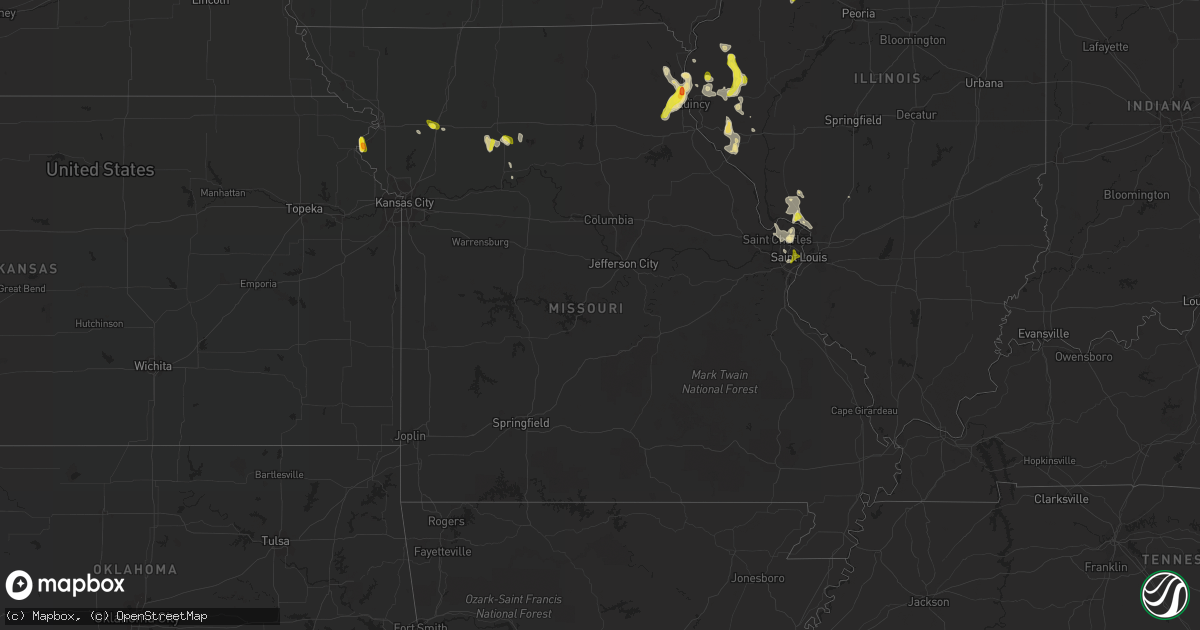
Hail Map in Missouri on May 26, 2018
Get this storm
May 26 map
$229
one time, instant access
Download today. No call, no setup
Keep the $229
Bought the map and want the full workflow? Apply the entire $229 to a subscription within 7 days. None of it is wasted.
Every map, not just this one
This buys you this map. Subscription and you get every map we run, in the markets you choose from a few cities to whole states to nationwide. Plus real-time alerts the moment a storm fires.
Contact data
Name, contact info, occupancy, even credit band for addresses in the footprint. You go from where it hit to who to call.
Become the source they trust
Unlimited branding weather history reports on demand. You already have the documented answer ready for the property owner, and you are the one who showed up with it.
Property data and RoofTrace estimates
Pull up any address you have got, its value and the exact code rules for that jurisdiction, straight from One Click Code. Then RoofTrace estimates the squares, pitch, and roof value, priced the way you price.
Storm reports in Missouri
Missouri
| Date | Description |
|---|---|
| 05/26/20186:56 PM CDT | Time estimated by radar. |
| 05/26/20186:40 PM CDT | A local report indicates 1.00 inch wind near 5 N MONTICELLO |
| 05/26/20185:05 PM CDT | A local report indicates 1.50 inch wind near RUSHVILLE |
| 05/26/20184:57 PM CDT | A local report indicates 1.25 inch wind near RUSHVILLE |
| 05/26/20184:44 PM CDT | A local report indicates 1.00 inch wind near RUSHVILLE |
| 05/26/20184:03 PM CDT | A local report indicates 1.25 inch wind near CAMERON |
| 05/26/20183:55 PM CDT | A local report indicates 1.00 inch wind near 1 SSE AVALON |
| 05/26/20186:59 AM CDT | At 1159 PM CDT, a severe thunderstorm was located over Godfrey, moving southeast at 10 mph. HAZARD...Quarter size hail. SOURCE...Radar indicated. IMPACT...Damage to vehicles is expected. Locations impacted include... Alton, Godfrey, Wood River, Bethalto, East Alton, Roxana, Hartford, Elsah, West Alton and Rosewood Heights.This also includes Confluence State Park. |
| 05/26/20182:24 AM CDT | Quarter size hill near bevo mill area. |
| 05/26/20182:17 AM CDT | Quarter size hail cracked a window pane. |
| 05/26/20182:16 AM CDT | Twitter report of quarter size hail. |
| 05/26/20182:07 AM CDT | Hampton village. |
| 05/26/20182:07 AM CDT | Ameren reports tree on power line near franz park. Time estimated from radar. |
| 05/26/20182:00 AM CDT | Tree down in clayton. |
| 05/26/20181:59 AM CDT | Report of a tree down near i-64 and i-170. |
| 05/26/20181:55 AM CDT | Large tree uprooted and fell onto house causing structural damage to home. Time estimated from radar. |
| 05/26/201812:45 AM CDT | At 544 PM CDT, a severe thunderstorm was located near Canton, moving southeast at 10 mph. HAZARD...60 mph wind gusts and quarter size hail. SOURCE...Radar indicated. IMPACT...Hail damage to vehicles is expected. Expect wind damage to roofs, siding, and trees. Locations impacted include... Canton, Mendon, La Grange, Ursa, Lima, Monticello and Meyer. This also includes Wakonda State Park. |
| 05/26/201812:10 AM CDT | At 509 PM CDT, a severe thunderstorm was located 8 miles south of Utica, or 12 miles south of Chillicothe, moving west at 10 mph. HAZARD...60 mph wind gusts and quarter size hail. SOURCE...Radar indicated. IMPACT...Hail damage to vehicles is expected. Expect wind damage to roofs, siding, and trees. Locations impacted include... Ludlow and Dawn. |
| 05/25/201811:43 PM CDT | At 442 PM CDT, a severe thunderstorm was located 8 miles south of Utica, or 11 miles south of Chillicothe, moving southeast at 5 mph. HAZARD...60 mph wind gusts and quarter size hail. SOURCE...Radar indicated. IMPACT...Hail damage to vehicles is expected. Expect wind damage to roofs, siding, and trees. Locations impacted include... Tina, Ludlow, Avalon and Dawn. |
| 05/25/201810:54 PM CDT | At 354 PM CDT, a severe thunderstorm was located over Hale, or 15 miles southeast of Chillicothe, moving southeast at 20 mph. HAZARD...60 mph wind gusts and quarter size hail. SOURCE...Radar indicated. IMPACT...Hail damage to vehicles is expected. Expect wind damage to roofs, siding, and trees. Locations impacted include... Hale, Mendon, Sumner, Triplett and Avalon. |
| 05/25/201810:51 PM CDT | At 351 PM CDT, a severe thunderstorm was located near Osborn, or near Cameron, moving southeast at 15 mph. HAZARD...60 mph wind gusts and quarter size hail. SOURCE...Radar indicated. IMPACT...Hail damage to vehicles is expected. Expect wind damage to roofs, siding, and trees. Locations impacted include... Cameron, Osborn and Turney. This includes Interstate 35 in Missouri between mile markers 42 and56. |
| 05/25/201810:23 PM CDT | At 322 PM CDT, a severe thunderstorm was located 8 miles northwest of Hale, or 9 miles southeast of Chillicothe, moving southeast at 10 mph. HAZARD...60 mph wind gusts and quarter size hail. SOURCE...Radar indicated. IMPACT...Hail damage to vehicles is expected. Expect wind damage to roofs, siding, and trees. Locations impacted include... Hale, Tina, Sumner and Avalon. |
| 05/25/20187:49 PM CDT | A local report indicates 1.00 inch wind near PHILADELPHIA |
| 05/25/20187:14 PM CDT | A local report indicates 1.00 inch wind near MAYWOOD |
All States Impacted by Hail Map on May 26, 2018
Cities Impacted by Hail Map on May 26, 2018
- Ishpeming, MI
- Negaunee, MI
- Eunice, LA
- Mcclusky, ND
- Wausaukee, WI
- Wallace, MI
- Lame Deer, MT
- Birney, MT
- Richey, MT
- Florissant, MO
- Hazelwood, MO
- Maywood, MO
- Taylor, MO
- La Grange, MO
- Wishek, ND
- Carthage, IL
- Tennessee, IL
- Clear Spring, MD
- Falling Waters, WV
- Lindsay, MT
- Terry, MT
- Bloomfield, MT
- Circle, MT
- Seymour, IN
- Canton, MO
- Warsaw, IL
- Quincy, IL
- Monticello, MO
- Philadelphia, MO
- Ursa, IL
- Palmyra, MO
- Durham, MO
- Geyser, MT
- San Augustine, TX
- Saint Francisville, LA
- Sturgeon Bay, WI
- Shoup, ID
- Jamestown, ND
- Jud, ND
- Ferriday, LA
- Hemlock, MI
- Saint Charles, MI
- Saginaw, MI
- Midland, MI
- Buna, TX
- Gwinn, MI
- Foster City, MI
- Wilton, ND
- Wallisville, TX
- Liberty, TX
- Lodge Grass, MT
- Oberlin, OH
- Kipton, OH
- Wakeman, OH
- Amherst, OH
- Berlin Heights, OH
- Beaumont, TX
- Winnie, TX
- Jerseyville, IL
- Dow, IL
- Godfrey, IL
- Brighton, IL
- Fort Peck, MT
- Nashua, MT
- Deville, LA
- Powers, MI
- Spalding, MI
- Decker, MT
- Sears, MI
- Lake, MI
- Barryton, MI
- Danbury, TX
- Rosharon, TX
- Glendive, MT
- Baileys Harbor, WI
- Fish Creek, WI
- Egg Harbor, WI
- Jasper, TX
- Zavalla, TX
- Woodville, TX
- Colmesneil, TX
- Warren, TX
- Chester, TX
- Livingston, TX
- Fredonia, ND
- Kulm, ND
- Collinston, LA
- Weidman, MI
- Remus, MI
- Kirbyville, TX
- Newton, TX
- Kountze, TX
- Bismarck, AR
- Bronson, TX
- Lambert, MT
- Winnsboro, LA
- Mercer, ND
- Turtle Lake, ND
- Columbia, LA
- New Sharon, IA
- Bark River, MI
- Vulcan, MI
- Stephenson, MI
- Daggett, MI
- Perronville, MI
- Carney, MI
- Hermansville, MI
- Wilson, MI
- Broaddus, TX
- Plymouth, IL
- Newellton, LA
- Saint Joseph, LA
- Regan, ND
- Baldwin, ND
- Marion, LA
- Dubach, LA
- Jordan, MT
- Hollandale, MS
- Chillicothe, MO
- Sumner, MO
- Hale, MO
- Iota, LA
- Evangeline, LA
- Basile, LA
- Jennings, LA
- Grand Marais, MN
- Fullerton, ND
- Oakes, ND
- Lamoure, ND
- North Fork, ID
- Goldonna, LA
- Winnfield, LA
- Berlin, ND
- Yazoo City, MS
- Anahuac, TX
- Rushville, MO
- Pearland, TX
- Houston, TX
- Galena Park, TX
- Manvel, TX
- Big Timber, MT
- Yorktown, AR
- Star City, AR
- Palmer, MI
- Medora, IL
- Fordoche, LA
- Silsbee, TX
- Republic, MI
- Champion, MI
- Tappen, ND
- Edgeley, ND
- Powell, WY
- Manton, MI
- Plattsburg, MO
- Stewartsville, MO
- Humble, TX
- Ingalls, MI
- Jonesville, LA
- Savage, MT
- Durand, MI
- Kingwood, TX
- Porter, TX
- Ryegate, MT
- Shawmut, MT
- McBain, MI
- Neponset, IL
- Sheffield, IL
- Fort Polk, LA
- Napoleon, ND
- Crow Agency, MT
- Saint Xavier, MT
- Colts Neck, NJ
- Holmdel, NJ
- Marlboro, NJ
- Lincroft, NJ
- Eatontown, NJ
- Old Bridge, NJ
- Morganville, NJ
- Jena, LA
- Trout, LA
- Vidor, TX
- Barry, IL
- Nadeau, MI
- Menominee, MI
- Martinsdale, MT
- Two Dot, MT
- Baylis, IL
- Liberty, IL
- Saint Louis, MO
- Clayton, LA
- Michigamme, MI
- Channing, MI
- Marquette, MI
- La Porte, TX
- Pasadena, TX
- Lake City, SD
- Britton, SD
- Owosso, MI
- Corunna, MI
- Lake Charles, LA
- Iowa, LA
- Chesaning, MI
- Lake City, MI
- Falmouth, MI
- Veblen, SD
- Goodrich, ND
- Denhoff, ND
- Gladwin, MI
- Harrison, MI
- Braddock, ND
- Driscoll, ND
- Moffit, ND
- Steele, ND
- Foxworth, MS
- Kokomo, MS
- Dayton, TX
- Deep River, IA
- Atchison, KS
- Cameron, LA
- Rupert, ID
- Fallon, MT
- Covington, MI
- Comins, MI
- Medina, ND
- Cleveland, ND
- Sisseton, SD
- Peever, SD
- Hillister, TX
- Bastrop, LA
- Sterlington, LA
- Monroe, LA
- Palmetto, LA
- Alton, IL
- Wolf Point, MT
- Butte, ND
- Houghton Lake, MI
- Saratoga, TX
- Carrollton, MO
- Tina, MO
- Dawn, MO
- Dawson, ND
- Washington, LA
- Lanse, MI
- Rose Hill, IA
- Pembine, WI
- Loretto, MI
- Norway, MI
- Crystal Falls, MI
- Grenville, SD
- Morton, MS
- Woodbury, NJ
- Paulsboro, NJ
- Thorofare, NJ
- Deridder, LA
- Ventress, LA
- Livonia, LA
- Oscar, LA
- New Roads, LA
- Jarreau, LA
- Freeland, MI
- Montrose, MI
- Merrill, MI
- Brant, MI
- Converse, LA
- Crosby, TX
- Highlands, TX
- West, MS
- Vaiden, MS
- Maringouin, LA
- Glasgow, MT
- Pitkin, LA
- Bowen, IL
- Golden, IL
- Clayton, IL
- La Prairie, IL
- Huntsville, IL
- Augusta, IL
- Timewell, IL
- Camp Point, IL
- Winchester, VA
- Star Tannery, VA
- Bogard, MO
- Ludlow, MO
- Westlake, LA
- Sewell, NJ
- Wenonah, NJ
- Gibbstown, NJ
- Mantua, NJ
- Woodbury Heights, NJ
- Kintyre, ND
- Dequincy, LA
- Sulphur, LA
- Glenmora, LA
- Hamshire, TX
- Hedrick, IA
- Fremont, IA
- Mendon, IL
- Loraine, IL
- Kidder, MO
- Cameron, MO
- Moultrie, GA
- Pierpont, SD
- Mangham, LA
- Rayville, LA
- Little Lake, MI
- Lachine, MI
- Montgomery, LA
- Atlanta, LA
- Missouri City, TX
- Fresno, TX
- Cogswell, ND
- Forman, ND
- Saline, LA
- Pittsfield, IL
- Pleasant Hill, IL
- Rockport, IL
- Gaylord, MI
- Alexander, ND
- Cartwright, ND
- Claire City, SD
- Bridgeton, MO
- Saint Charles, MO
- Huffman, TX
- Columbia, MS
- Crescent Valley, NV
- Griggsville, IL
- Monterey, LA
- Bon Wier, TX
- Clearmont, WY
- Brownstown, IN
- Gwinner, ND
- Oakdale, LA
- Lumberton, MS
- Wing, ND
- Wilsall, MT
- Tallulah, LA
- Columbus, IN
- Chambersburg, IL
- Ellison Bay, WI
- Clancy, MT
- Lake Providence, LA
- Dodson, LA
- Sikes, LA
- Starks, LA
- Tullos, LA
- Alvin, TX
- Webster, TX
- Friendswood, TX
- Cardwell, MT
- Harrison, MT
- Mount Royal, NJ
- Voltaire, ND
- Ruso, ND
- Louann, AR
- Wellington, OH
- Fowler, IL
- Paloma, IL
- Banner, WY
- Sheridan, WY
- High View, WV
- Strasburg, VA
- Natchitoches, LA
- Call, TX
- League City, TX
- Merritt, MI
- Sour Lake, TX
- Augusta, MT
- Natchez, LA
- Melrose, LA
- Brussels, WI
- Oconto, WI
- Rapidan, VA
- Mitchells, VA
- Culpeper, VA
- Merryville, LA
- Milam, TX
- Sterling, ND
- Smackover, AR
- Vida, MT
- Ypsilanti, ND
- Monticello, MS
- Oak Vale, MS
- New Canton, IL
- New Salem, IL
- Reed Point, MT
- Pettibone, ND
- Center, TX
- Shelbyville, TX
- Streeter, ND
- Port Arthur, TX
- Buffalo, WY
- Otway, OH
- McDermott, OH
- Otter, MT
- Brockway, MT
- Anguilla, MS
- Springer, OK
- Wibaux, MT
- Port Gibson, MS
- Frazer, MT
- Dickinson, TX
- Seabrook, TX
- Kemah, TX
- Deer Park, TX
- Channelview, TX
- Baytown, TX
- South Houston, TX
- Sidney, MT
- Orange, TX
- Benedict, ND
- Williamstown, MO
- Verona, ND
- Welsh, LA
- Philadelphia, PA
- Clarksboro, NJ
- Amberg, WI
- Gackle, ND
- Paul, ID
- Bunkie, LA
- Poplarville, MS
- Menoken, ND
- Leesville, LA
- Livingston, MT
- Stirum, ND
- Ville Platte, LA
- Heyburn, ID
- Burley, ID
- Goodman, WI
- Pineville, LA
- Saint Amant, LA
- Prudenville, MI
- Litchfield, IL
- Cloutierville, LA
- Bell City, LA
- Havana, ND
- Rutland, ND
- Tuttle, ND
- Stanford, MT
- Ephraim, WI
- Sister Bay, WI
- Jackson, LA
- Ethel, LA
- Roscommon, MI
- New Town, ND
- Keswick, IA
- Singer, LA
- Galesburg, IL
- Knoxville, IL
- East Galesburg, IL
- Sykeston, ND
- Cody, WY
- Opelousas, LA
- Wood River, IL
- East Alton, IL
- Webster, SD
- Poplar, MT
- Mesick, MI
- Cohagen, MT
- Sutter, IL
- Belzoni, MS
- Louise, MS
- Ketchum, ID
- Silver City, MS
- Sand Springs, MT
- Felch, MI
- Freehold, NJ
- Howell, NJ
- Devers, TX
- Hankamer, TX
- White Sulphur Springs, MT
- Saint Helen, MI
- Bradley, SD
- Conde, SD
- Egan, LA
- Lena, LA
- Braymer, MO
- Fairview, MT
- Belmar, NJ
- Coatsburg, IL
- Grace, ID
- Abingdon, IL
- Maquon, IL
- Gilson, IL
- De Kalb, MO
- Frederic, MI
- West Point, IL


