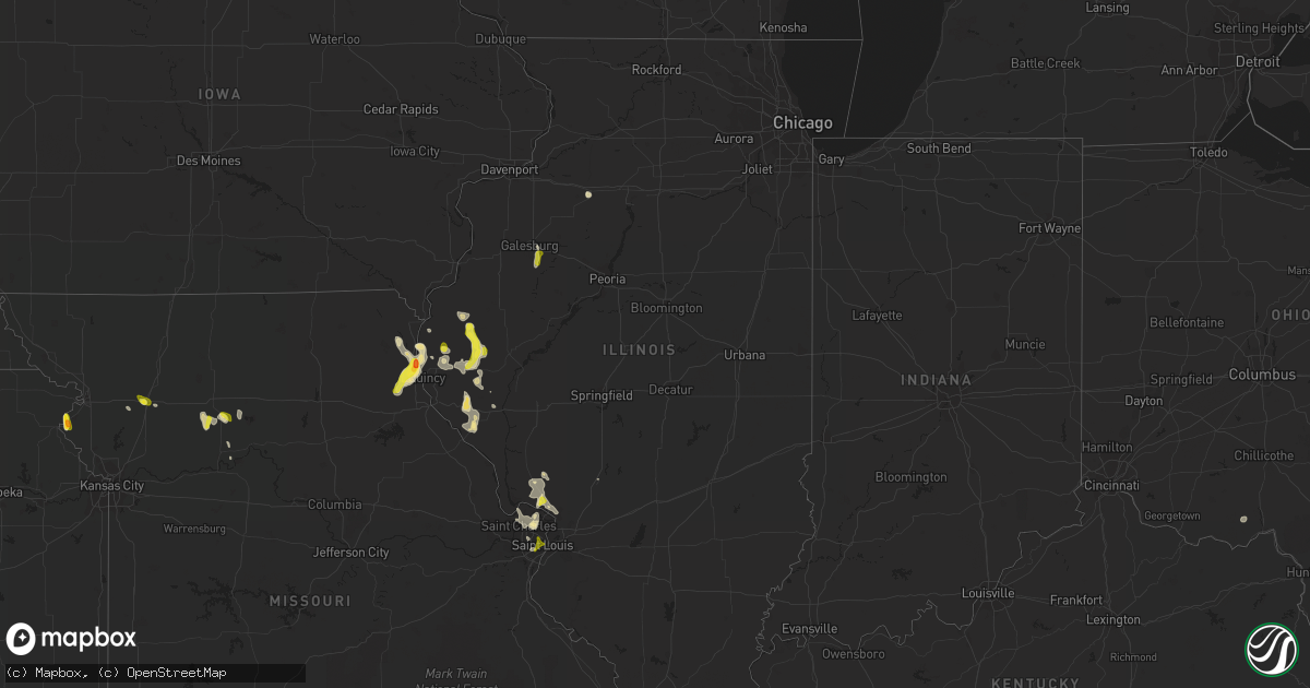
Hail Map in Illinois on May 26, 2018
Get this storm
May 26 map
$229
one time, instant access
Download today. No call, no setup
Keep the $229
Bought the map and want the full workflow? Apply the entire $229 to a subscription within 7 days. None of it is wasted.
Every map, not just this one
This buys you this map. Subscription and you get every map we run, in the markets you choose from a few cities to whole states to nationwide. Plus real-time alerts the moment a storm fires.
Contact data
Name, contact info, occupancy, even credit band for addresses in the footprint. You go from where it hit to who to call.
Become the source they trust
Unlimited branding weather history reports on demand. You already have the documented answer ready for the property owner, and you are the one who showed up with it.
Property data and RoofTrace estimates
Pull up any address you have got, its value and the exact code rules for that jurisdiction, straight from One Click Code. Then RoofTrace estimates the squares, pitch, and roof value, priced the way you price.
Storm reports in Illinois
Illinois
| Date | Description |
|---|---|
| 05/26/20185:40 PM CDT | Social media report |
| 05/26/20184:32 PM CDT | Penny to quarter sized hail covering the road. |
| 05/26/20184:25 PM CDT | Delayed report. |
| 05/26/20184:25 PM CDT | Quarter size hail 0.5 miles west of plymouth. |
| 05/26/20184:23 PM CDT | Pea to quarter size hail for 3 to 5 minutes. |
| 05/26/20181:50 AM CDT | At 650 PM CDT, a severe thunderstorm was located over La Grange, moving south at 15 mph. HAZARD...60 mph wind gusts and half dollar size hail. SOURCE...Radar indicated. IMPACT...Hail damage to vehicles is expected. Expect wind damage to roofs, siding, and trees. Locations impacted include... Quincy, Palmyra, Payson, La Grange, Maywood, Taylor and Marblehead.This includes Interstate 172 between exits 10 and 15. This also includes Wakonda State Park. |
| 05/26/20181:20 AM CDT | At 619 PM CDT, a severe thunderstorm was located near London Mills, or 13 miles south of Galesburg, moving south at 10 mph. HAZARD...60 mph wind gusts and quarter size hail. SOURCE...Radar indicated. IMPACT...Hail damage to vehicles is expected. Expect wind damage to roofs, siding, and trees. Locations impacted include... Avon, Fairview, London Mills, St. Augustine and Ellisville. |
| 05/26/201812:33 AM CDT | At 533 PM CDT, a severe thunderstorm was located over Gilson, or 10 miles southeast of Galesburg, moving southeast at 10 mph. HAZARD...60 mph wind gusts and quarter size hail. SOURCE...Radar indicated. IMPACT...Hail damage to vehicles is expected. Expect wind damage to roofs, siding, and trees. Locations impacted include... Knoxville, Yates City, Maquon, Gilson and Delong. This includes Interstate 74 between mile markers 51 and 61. |
| 05/26/201812:28 AM CDT | At 527 PM CDT, severe thunderstorms were located along a line extending from near Mendon to near Mount Sterling, moving southeast at 30 mph. HAZARD...60 mph wind gusts and quarter size hail. SOURCE...Radar indicated. IMPACT...Hail damage to vehicles is expected. Expect wind damage to roofs, siding, and trees. Locations impacted include... Quincy Regional Airport, Mount Sterling, Camp Point, Payson, Mendon, Clayton, Golden, Beverly, Buckhorn, Adams, Kingston, Burton, Liberty, Versailles, Richfield, Perry, Loraine, Plainville, Woodville and Chambersburg.This also includes Siloam Springs State Park. |
| 05/26/201812:19 AM CDT | At 518 PM CDT, a severe thunderstorm was located over Nauvoo, and is nearly stationary. HAZARD...60 mph wind gusts and quarter size hail. SOURCE...Radar indicated. IMPACT...Hail damage to vehicles is expected. Expect wind damage to roofs, siding, and trees. Locations impacted include... Fort Madison, Nauvoo, Montrose, Bluff Park, Galland, Nauvoo State Park and Sandusky. |
| 05/26/201812:14 AM CDT | At 514 PM CDT, a severe thunderstorm was located near Augusta, or 17 miles west of Rushville, moving south at 10 mph. HAZARD...60 mph wind gusts and quarter size hail. SOURCE...Trained weather spotters. IMPACT...Hail damage to vehicles is expected. Expect wind damage to roofs, siding, and trees. Locations impacted include... Huntsville and Camden. |
| 05/26/201812:02 AM CDT | Via twitter. |
| 05/25/201811:58 PM CDT | At 458 PM CDT, a severe thunderstorm was located over Augusta, moving south at 15 mph. HAZARD...60 mph wind gusts and quarter size hail. SOURCE...Radar indicated. IMPACT...Hail damage to vehicles is expected. Expect wind damage to roofs, siding, and trees. Locations impacted include... Clayton and La Prairie. |
| 05/25/201811:42 PM CDT | At 441 PM CDT, a severe thunderstorm was located near Colmar, or 12 miles southeast of Carthage, and is nearly stationary. HAZARD...60 mph wind gusts and quarter size hail. SOURCE...Trained weather spotters. IMPACT...Hail damage to vehicles is expected. Expect wind damage to roofs, siding, and trees. Locations impacted include... Carthage, Augusta, Ferris, Tennessee, Colmar, Plymouth, Fountain Green, Bentley, Webster and Hancock County Fairgrounds. |
| 05/25/201811:24 PM CDT | At 424 PM CDT, a severe thunderstorm was located 8 miles northeast of Clayton, moving southeast at 5 mph. HAZARD...60 mph wind gusts and quarter size hail. SOURCE...Radar indicated. IMPACT...Hail damage to vehicles is expected. Expect wind damage to roofs, siding, and trees. Locations impacted include... Mount Sterling and Mound Station. |
| 05/25/201811:22 PM CDT | At 421 PM CDT, a severe thunderstorm was located over Augusta, or 16 miles southeast of Carthage, moving southeast at 10 mph. HAZARD...60 mph wind gusts and quarter size hail. SOURCE...Radar indicated. IMPACT...Hail damage to vehicles is expected. Expect wind damage to roofs, siding, and trees. Locations impacted include... Huntsville, Camden and Weinberg King State Park. |
| 05/25/201810:59 PM CDT | At 358 PM CDT, a severe thunderstorm was located near Carthage, moving southeast at 10 mph. HAZARD...Quarter size hail. SOURCE...Radar indicated. IMPACT...Damage to vehicles is expected. Locations impacted include... Carthage, Augusta, Tennessee, Fandon, Colmar, Plymouth, Fountain Green, Webster and Hancock County Fairgrounds. |
All States Impacted by Hail Map on May 26, 2018
Cities Impacted by Hail Map on May 26, 2018
- Ishpeming, MI
- Negaunee, MI
- Eunice, LA
- Mcclusky, ND
- Wausaukee, WI
- Wallace, MI
- Lame Deer, MT
- Birney, MT
- Richey, MT
- Florissant, MO
- Hazelwood, MO
- Maywood, MO
- Taylor, MO
- La Grange, MO
- Wishek, ND
- Carthage, IL
- Tennessee, IL
- Clear Spring, MD
- Falling Waters, WV
- Lindsay, MT
- Terry, MT
- Bloomfield, MT
- Circle, MT
- Seymour, IN
- Canton, MO
- Warsaw, IL
- Quincy, IL
- Monticello, MO
- Philadelphia, MO
- Ursa, IL
- Palmyra, MO
- Durham, MO
- Geyser, MT
- San Augustine, TX
- Saint Francisville, LA
- Sturgeon Bay, WI
- Shoup, ID
- Jamestown, ND
- Jud, ND
- Ferriday, LA
- Hemlock, MI
- Saint Charles, MI
- Saginaw, MI
- Midland, MI
- Buna, TX
- Gwinn, MI
- Foster City, MI
- Wilton, ND
- Wallisville, TX
- Liberty, TX
- Lodge Grass, MT
- Oberlin, OH
- Kipton, OH
- Wakeman, OH
- Amherst, OH
- Berlin Heights, OH
- Beaumont, TX
- Winnie, TX
- Jerseyville, IL
- Dow, IL
- Godfrey, IL
- Brighton, IL
- Fort Peck, MT
- Nashua, MT
- Deville, LA
- Powers, MI
- Spalding, MI
- Decker, MT
- Sears, MI
- Lake, MI
- Barryton, MI
- Danbury, TX
- Rosharon, TX
- Glendive, MT
- Baileys Harbor, WI
- Fish Creek, WI
- Egg Harbor, WI
- Jasper, TX
- Zavalla, TX
- Woodville, TX
- Colmesneil, TX
- Warren, TX
- Chester, TX
- Livingston, TX
- Fredonia, ND
- Kulm, ND
- Collinston, LA
- Weidman, MI
- Remus, MI
- Kirbyville, TX
- Newton, TX
- Kountze, TX
- Bismarck, AR
- Bronson, TX
- Lambert, MT
- Winnsboro, LA
- Mercer, ND
- Turtle Lake, ND
- Columbia, LA
- New Sharon, IA
- Bark River, MI
- Vulcan, MI
- Stephenson, MI
- Daggett, MI
- Perronville, MI
- Carney, MI
- Hermansville, MI
- Wilson, MI
- Broaddus, TX
- Plymouth, IL
- Newellton, LA
- Saint Joseph, LA
- Regan, ND
- Baldwin, ND
- Marion, LA
- Dubach, LA
- Jordan, MT
- Hollandale, MS
- Chillicothe, MO
- Sumner, MO
- Hale, MO
- Iota, LA
- Evangeline, LA
- Basile, LA
- Jennings, LA
- Grand Marais, MN
- Fullerton, ND
- Oakes, ND
- Lamoure, ND
- North Fork, ID
- Goldonna, LA
- Winnfield, LA
- Berlin, ND
- Yazoo City, MS
- Anahuac, TX
- Rushville, MO
- Pearland, TX
- Houston, TX
- Galena Park, TX
- Manvel, TX
- Big Timber, MT
- Yorktown, AR
- Star City, AR
- Palmer, MI
- Medora, IL
- Fordoche, LA
- Silsbee, TX
- Republic, MI
- Champion, MI
- Tappen, ND
- Edgeley, ND
- Powell, WY
- Manton, MI
- Plattsburg, MO
- Stewartsville, MO
- Humble, TX
- Ingalls, MI
- Jonesville, LA
- Savage, MT
- Durand, MI
- Kingwood, TX
- Porter, TX
- Ryegate, MT
- Shawmut, MT
- McBain, MI
- Neponset, IL
- Sheffield, IL
- Fort Polk, LA
- Napoleon, ND
- Crow Agency, MT
- Saint Xavier, MT
- Colts Neck, NJ
- Holmdel, NJ
- Marlboro, NJ
- Lincroft, NJ
- Eatontown, NJ
- Old Bridge, NJ
- Morganville, NJ
- Jena, LA
- Trout, LA
- Vidor, TX
- Barry, IL
- Nadeau, MI
- Menominee, MI
- Martinsdale, MT
- Two Dot, MT
- Baylis, IL
- Liberty, IL
- Saint Louis, MO
- Clayton, LA
- Michigamme, MI
- Channing, MI
- Marquette, MI
- La Porte, TX
- Pasadena, TX
- Lake City, SD
- Britton, SD
- Owosso, MI
- Corunna, MI
- Lake Charles, LA
- Iowa, LA
- Chesaning, MI
- Lake City, MI
- Falmouth, MI
- Veblen, SD
- Goodrich, ND
- Denhoff, ND
- Gladwin, MI
- Harrison, MI
- Braddock, ND
- Driscoll, ND
- Moffit, ND
- Steele, ND
- Foxworth, MS
- Kokomo, MS
- Dayton, TX
- Deep River, IA
- Atchison, KS
- Cameron, LA
- Rupert, ID
- Fallon, MT
- Covington, MI
- Comins, MI
- Medina, ND
- Cleveland, ND
- Sisseton, SD
- Peever, SD
- Hillister, TX
- Bastrop, LA
- Sterlington, LA
- Monroe, LA
- Palmetto, LA
- Alton, IL
- Wolf Point, MT
- Butte, ND
- Houghton Lake, MI
- Saratoga, TX
- Carrollton, MO
- Tina, MO
- Dawn, MO
- Dawson, ND
- Washington, LA
- Lanse, MI
- Rose Hill, IA
- Pembine, WI
- Loretto, MI
- Norway, MI
- Crystal Falls, MI
- Grenville, SD
- Morton, MS
- Woodbury, NJ
- Paulsboro, NJ
- Thorofare, NJ
- Deridder, LA
- Ventress, LA
- Livonia, LA
- Oscar, LA
- New Roads, LA
- Jarreau, LA
- Freeland, MI
- Montrose, MI
- Merrill, MI
- Brant, MI
- Converse, LA
- Crosby, TX
- Highlands, TX
- West, MS
- Vaiden, MS
- Maringouin, LA
- Glasgow, MT
- Pitkin, LA
- Bowen, IL
- Golden, IL
- Clayton, IL
- La Prairie, IL
- Huntsville, IL
- Augusta, IL
- Timewell, IL
- Camp Point, IL
- Winchester, VA
- Star Tannery, VA
- Bogard, MO
- Ludlow, MO
- Westlake, LA
- Sewell, NJ
- Wenonah, NJ
- Gibbstown, NJ
- Mantua, NJ
- Woodbury Heights, NJ
- Kintyre, ND
- Dequincy, LA
- Sulphur, LA
- Glenmora, LA
- Hamshire, TX
- Hedrick, IA
- Fremont, IA
- Mendon, IL
- Loraine, IL
- Kidder, MO
- Cameron, MO
- Moultrie, GA
- Pierpont, SD
- Mangham, LA
- Rayville, LA
- Little Lake, MI
- Lachine, MI
- Montgomery, LA
- Atlanta, LA
- Missouri City, TX
- Fresno, TX
- Cogswell, ND
- Forman, ND
- Saline, LA
- Pittsfield, IL
- Pleasant Hill, IL
- Rockport, IL
- Gaylord, MI
- Alexander, ND
- Cartwright, ND
- Claire City, SD
- Bridgeton, MO
- Saint Charles, MO
- Huffman, TX
- Columbia, MS
- Crescent Valley, NV
- Griggsville, IL
- Monterey, LA
- Bon Wier, TX
- Clearmont, WY
- Brownstown, IN
- Gwinner, ND
- Oakdale, LA
- Lumberton, MS
- Wing, ND
- Wilsall, MT
- Tallulah, LA
- Columbus, IN
- Chambersburg, IL
- Ellison Bay, WI
- Clancy, MT
- Lake Providence, LA
- Dodson, LA
- Sikes, LA
- Starks, LA
- Tullos, LA
- Alvin, TX
- Webster, TX
- Friendswood, TX
- Cardwell, MT
- Harrison, MT
- Mount Royal, NJ
- Voltaire, ND
- Ruso, ND
- Louann, AR
- Wellington, OH
- Fowler, IL
- Paloma, IL
- Banner, WY
- Sheridan, WY
- High View, WV
- Strasburg, VA
- Natchitoches, LA
- Call, TX
- League City, TX
- Merritt, MI
- Sour Lake, TX
- Augusta, MT
- Natchez, LA
- Melrose, LA
- Brussels, WI
- Oconto, WI
- Rapidan, VA
- Mitchells, VA
- Culpeper, VA
- Merryville, LA
- Milam, TX
- Sterling, ND
- Smackover, AR
- Vida, MT
- Ypsilanti, ND
- Monticello, MS
- Oak Vale, MS
- New Canton, IL
- New Salem, IL
- Reed Point, MT
- Pettibone, ND
- Center, TX
- Shelbyville, TX
- Streeter, ND
- Port Arthur, TX
- Buffalo, WY
- Otway, OH
- McDermott, OH
- Otter, MT
- Brockway, MT
- Anguilla, MS
- Springer, OK
- Wibaux, MT
- Port Gibson, MS
- Frazer, MT
- Dickinson, TX
- Seabrook, TX
- Kemah, TX
- Deer Park, TX
- Channelview, TX
- Baytown, TX
- South Houston, TX
- Sidney, MT
- Orange, TX
- Benedict, ND
- Williamstown, MO
- Verona, ND
- Welsh, LA
- Philadelphia, PA
- Clarksboro, NJ
- Amberg, WI
- Gackle, ND
- Paul, ID
- Bunkie, LA
- Poplarville, MS
- Menoken, ND
- Leesville, LA
- Livingston, MT
- Stirum, ND
- Ville Platte, LA
- Heyburn, ID
- Burley, ID
- Goodman, WI
- Pineville, LA
- Saint Amant, LA
- Prudenville, MI
- Litchfield, IL
- Cloutierville, LA
- Bell City, LA
- Havana, ND
- Rutland, ND
- Tuttle, ND
- Stanford, MT
- Ephraim, WI
- Sister Bay, WI
- Jackson, LA
- Ethel, LA
- Roscommon, MI
- New Town, ND
- Keswick, IA
- Singer, LA
- Galesburg, IL
- Knoxville, IL
- East Galesburg, IL
- Sykeston, ND
- Cody, WY
- Opelousas, LA
- Wood River, IL
- East Alton, IL
- Webster, SD
- Poplar, MT
- Mesick, MI
- Cohagen, MT
- Sutter, IL
- Belzoni, MS
- Louise, MS
- Ketchum, ID
- Silver City, MS
- Sand Springs, MT
- Felch, MI
- Freehold, NJ
- Howell, NJ
- Devers, TX
- Hankamer, TX
- White Sulphur Springs, MT
- Saint Helen, MI
- Bradley, SD
- Conde, SD
- Egan, LA
- Lena, LA
- Braymer, MO
- Fairview, MT
- Belmar, NJ
- Coatsburg, IL
- Grace, ID
- Abingdon, IL
- Maquon, IL
- Gilson, IL
- De Kalb, MO
- Frederic, MI
- West Point, IL


