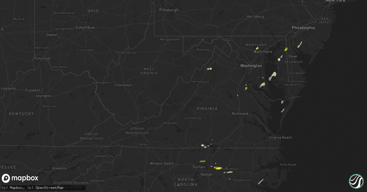
Hail Map in Virginia on May 25, 2017
Get this storm
May 25 map
$229
one time, instant access
Download today. No call, no setup
Keep the $229
Bought the map and want the full workflow? Apply the entire $229 to a subscription within 7 days. None of it is wasted.
Every map, not just this one
This buys you this map. Subscription and you get every map we run, in the markets you choose from a few cities to whole states to nationwide. Plus real-time alerts the moment a storm fires.
Contact data
Name, contact info, occupancy, even credit band for addresses in the footprint. You go from where it hit to who to call.
Become the source they trust
Unlimited branding weather history reports on demand. You already have the documented answer ready for the property owner, and you are the one who showed up with it.
Property data and RoofTrace estimates
Pull up any address you have got, its value and the exact code rules for that jurisdiction, straight from One Click Code. Then RoofTrace estimates the squares, pitch, and roof value, priced the way you price.
Storm reports in Virginia
Virginia
| Date | Description |
|---|---|
| 05/25/20174:27 PM CDT | Mesonet station xsnj... South norfolk jordan bridge. |
| 05/25/20174:12 PM CDT | Tree down near the intersection of graham park road and cabin road. |
| 05/25/20173:28 PM CDT | Dime to quarter size hail |
| 05/25/20171:03 PM CDT | Mesonet station at589... 2 wsw kenbridge. |
All States Impacted by Hail Map on May 25, 2017
Cities Impacted by Hail Map on May 25, 2017
- Emporia, KS
- Penokee, KS
- Hoxie, KS
- Morland, KS
- Bath, NC
- Pinetown, NC
- Belhaven, NC
- Pantego, NC
- Edson, KS
- Winona, KS
- Gove, KS
- Quinter, KS
- Saint Francis, KS
- Wray, CO
- Idalia, CO
- Dodge City, KS
- Jetmore, KS
- Little River, KS
- Louisburg, NC
- Hollywood, MD
- Avenue, MD
- Loveville, MD
- Broomes Island, MD
- Saint Leonard, MD
- Clements, MD
- Leonardtown, MD
- Mechanicsville, MD
- Woodstock, MD
- Owings Mills, MD
- Randallstown, MD
- La Cygne, KS
- Fontana, KS
- Edinburg, VA
- Fort Valley, VA
- Wheatland, MO
- Hermitage, MO
- Waverly, KS
- Lebo, KS
- Richmond, KS
- Melvern, KS
- Williamsburg, KS
- Princeton, KS
- Centreville, MD
- Church Hill, MD
- Pittsburg, MO
- Flemington, MO
- Collins, MO
- Weaubleau, MO
- Ellis, KS
- Hays, KS
- Lehigh, KS
- Marion, KS
- Hillsboro, KS
- Tampa, KS
- Pleasanton, KS
- Amoret, MO
- Appleton City, MO
- Butler, MO
- Montrose, MO
- Foster, MO
- Akron, CO
- Otis, CO
- Urbana, MO
- Humansville, MO
- Colby, KS
- Oakley, KS
- Roby, MO
- Lynchburg, MO
- Falcon, MO
- Lebanon, MO
- Grovespring, MO
- Mountain Grove, MO
- Plato, MO
- Preston, MO
- Macks Creek, MO
- Greeley, KS
- Rantoul, KS
- Lane, KS
- Waldo, KS
- Barnard, KS
- Lincoln, KS
- Lucas, KS
- Russell, KS
- Minneapolis, KS
- Bunker Hill, KS
- Luray, KS
- Sylvan Grove, KS
- Americus, KS
- Rexford, KS
- Wilson, KS
- Gorham, KS
- Victoria, KS
- Dorrance, KS
- Walker, KS
- Windyville, MO
- Buffalo, MO
- Long Lane, MO
- La Crosse, KS
- Bison, KS
- Lindon, CO
- Anton, CO
- Clinton, MO
- Tunas, MO
- Yuma, CO
- Virgilina, VA
- Buffalo Junction, VA
- Nelson, VA
- El Dorado Springs, MO
- Schell City, MO
- Royal Oak, MD
- Neosho Rapids, KS
- Damar, KS
- Bogue, KS
- Conway, MO
- Fleming, CO
- Grinnell, KS
- Ogallah, KS
- Wakeeney, KS
- Oxford, MD
- Blairstown, MO
- Urich, MO
- Chilhowee, MO
- Osceola, MO
- Collyer, KS
- Eckley, CO
- Youngsville, NC
- Wake Forest, NC
- Paradise, KS
- Garnett, KS
- Shiloh, NJ
- Bridgeton, NJ
- Greenwich, NJ
- Wright, KS
- Heathsville, VA
- Reedville, VA
- Elm City, NC
- Rocky Mount, NC
- Louisburg, KS
- Sunset Beach, NC
- Louisburg, MO
- Cambridge, MD
- Trappe, MD
- Monument, KS
- Levant, KS
- Goodland, KS
- Wallace, KS
- Champion, NE
- Brunswick, MO
- Osage City, KS
- Reading, KS
- Osawatomie, KS
- Elmer, NJ
- Parker, KS
- Painter, VA
- Hacksneck, VA
- Belle Haven, VA
- Bunn, NC
- Spring Hope, NC
- Zebulon, NC
- Satanta, KS
- Ulysses, KS
- Clarksville, VA
- Windsor, MO
- Strong City, KS
- Canton, KS
- Elmdale, KS
- Durham, KS
- Lincolnville, KS
- Holyoke, CO
- Ellicott City, MD
- Park, KS
- Grainfield, KS
- Pinetops, NC
- Montreal, MO
- Camdenton, MO
- Kanorado, KS
- Wilsey, KS
- Burlington, CO
- Windom, KS
- Eldridge, MO
- Natoma, KS
- Quincy, MO
- Kirk, CO
- Drexel, MO
- Huntingtown, MD
- Prince Frederick, MD
- Phillipsburg, MO
- Centerville, KS
- Nanjemoy, MD
- Woodford, VA
- Quenemo, KS
- Amsterdam, MO
- Adrian, MO
- Paola, KS
- Bird City, KS
- Vernon, CO
- Brewster, KS
- Burdick, KS
- Galva, KS
- Massey, MD
- Townsend, DE
- Galena, MD
- Hill City, KS
- Creighton, MO
- King George, VA
- Rockville, MO
- Harwood, MO
- Mount Jackson, VA
- Admire, KS
- Lowry City, MO
- Deepwater, MO
- Boydton, VA
- Cross Timbers, MO
- Council Grove, KS
- Mound City, KS
- Westphalia, KS
- Lost Springs, KS
- Roxbury, KS
- Nashville, NC
- Haxtun, CO
- Sterling, CO
- Easton, MD
- Chestertown, MD
- Sudlersville, MD
- Willow Springs, MO
- Deal Island, MD
- Princess Anne, MD
- Supply, NC
- Garden City, MO
- Archie, MO
- Wilson, NC
- Bailey, NC
- Roach, MO
- Walker, MO
- Robbins, NC
- Waldorf, MD
- Success, MO
- Chase City, VA
- Plainville, KS
- Chase, KS
- Pikesville, MD
- Warwick, MD
- Stockton, MO
- Salisbury, MO
- Keytesville, MO
- Utica, KS
- Pomona, KS
- Bahama, NC
- Butner, NC
- Creedmoor, NC
- Stem, NC


