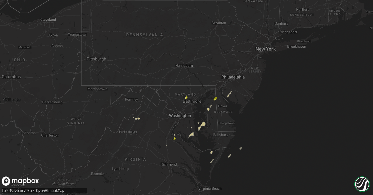
Hail Map on May 25, 2017
Get this storm
May 25 map
$229
one time, instant access
Download today. No call, no setup
Keep the $229
Bought the map and want the full workflow? Apply the entire $229 to a subscription within 7 days. None of it is wasted.
Every map, not just this one
This buys you this map. Subscription and you get every map we run, in the markets you choose from a few cities to whole states to nationwide. Plus real-time alerts the moment a storm fires.
Contact data
Name, contact info, occupancy, even credit band for addresses in the footprint. You go from where it hit to who to call.
Become the source they trust
Unlimited branding weather history reports on demand. You already have the documented answer ready for the property owner, and you are the one who showed up with it.
Property data and RoofTrace estimates
Pull up any address you have got, its value and the exact code rules for that jurisdiction, straight from One Click Code. Then RoofTrace estimates the squares, pitch, and roof value, priced the way you price.
States Impacted by Hail Map on May 25, 2017
Storm reports
New Jersey
| Date | Description |
|---|---|
| 05/25/20174:55 PM CDT | A local report indicates 1.00 inch wind near SHILOH |
Virginia
| Date | Description |
|---|---|
| 05/25/20174:27 PM CDT | Mesonet station xsnj... South norfolk jordan bridge. |
| 05/25/20174:12 PM CDT | Tree down near the intersection of graham park road and cabin road. |
| 05/25/20173:28 PM CDT | Dime to quarter size hail |
| 05/25/20171:03 PM CDT | Mesonet station at589... 2 wsw kenbridge. |
Missouri
| Date | Description |
|---|---|
| 05/25/20175:55 AM CDT | Delayed report. Hail larger than quarters in roby this morning. |
| 05/25/20175:19 AM CDT | 1 inch hail reported near bynumville. Time estimated from radar. |
| 05/25/20175:00 AM CDT | Delayed report... Social media picture of at least quarter size hail in urbana this morning. |
| 05/25/20174:55 AM CDT | A local report indicates 1.00 inch wind near NEMO |
| 05/25/20174:37 AM CDT | A local report indicates 1.00 inch wind near 3 W PITTSBURG |
| 05/25/20174:30 AM CDT | A local report indicates 1.50 inch wind near ELKTON |
| 05/25/20174:22 AM CDT | A local report indicates 1.75 inch wind near WEAUBLEAU |
| 05/25/20174:18 AM CDT | A local report indicates 1.00 inch wind near COLLINS |
North Carolina
| Date | Description |
|---|---|
| 05/25/20174:45 PM CDT | Quarter size hail was reported near i-85 and nc highway 56. |
| 05/25/20173:45 PM CDT | Quarter size hail was reported along us highway 301 near sharpe road. |
| 05/25/20173:25 PM CDT | Public reported dime to quarter sized hail in pantego. |
| 05/25/20172:55 PM CDT | Quarter sized hail at the campground at lake royale. Hail lasted for 14 minutes and is covering the ground. |
| 05/25/20172:40 PM CDT | Quarter to half dollar size hail was reported along hayes road near seven paths road between 340 - 355 pm. The duration of the hail event was 15 minutes. |
| 05/25/20172:36 PM CDT | Fort fisher blvd reported 51 knot |
| 05/25/201711:58 AM CDT | Orange county 911 received report of a tree down on powerlines in hilsborough off of hwy 70. |
Colorado
| Date | Description |
|---|---|
| 05/25/20174:35 PM CDT | Lasted roughly 5 minutes. |
| 05/25/20174:30 PM CDT | Locations east of this spot had 3-4 inches deep of nickel hail |
| 05/25/20174:27 PM CDT | Windsheild smashed. Isolated stones larger than baseballs. |
| 05/25/20174:15 PM CDT | A local report indicates 1.25 inch wind near 7 S YUMA |
| 05/25/20173:19 PM CDT | Spotter reported quarter sized hail north of eckley... Co. |
| 05/25/20172:58 PM CDT | A local report indicates 1.00 inch wind near SE PLATNER |
| 05/25/20172:44 PM CDT | A local report indicates 1.00 inch wind near 10 SSW FLEMING |
| 05/25/20172:05 PM CDT | Weak tornado. Brief touchdown in open field. No damage reported. |
| 05/24/201710:15 PM CDT | Trained weather spotter reported power outage in hermosa due to downed trees potentially associated with the dry microburst and line of thunderstorms that went through |
| 05/24/20179:32 PM CDT | Law enforcement reported trees and power lines down at the corner of junction and pleasant st... Durango... Co. |
| 05/24/20179:30 PM CDT | Trees and power lines down reported at aspen dr and aspen pl... Durango... Co. |
Maryland
| Date | Description |
|---|---|
| 05/25/20176:18 PM CDT | Tree down |
| 05/25/20176:15 PM CDT | Tree down on seminary avenue at mays chapel road |
| 05/25/20176:06 PM CDT | Quarter size hail |
| 05/25/20176:05 PM CDT | Tree down on 900 block of greenspring valley road |
| 05/25/20176:05 PM CDT | Tree down on dolfield blvd at lakeside blvd |
| 05/25/20176:05 PM CDT | Tree down on offutt road at samoset road |
| 05/25/20175:49 PM CDT | Several medium to large trees snapped or uprooted |
| 05/25/20174:11 PM CDT | Tree down in the 25500 block of loveville road. |
South Carolina
| Date | Description |
|---|---|
| 05/25/20171:29 PM CDT | Trees down near longs |
| 05/25/20171:20 PM CDT | Tree blown down near intersection of highway 905 and highway 19 |
| 05/25/201712:59 PM CDT | Tree blown down on roadway near intersection horry rd and enoch rd |
Kansas
| Date | Description |
|---|---|
| 05/25/20176:45 PM CDT | Public report via social media of wind damage. Flag pole snapped in half... Two wind chimes lost... And a couple of downed trees. |
| 05/25/20176:45 PM CDT | Koel site reported a wind gust of 68 mph. |
| 05/25/20176:22 PM CDT | Morton machinery building blown down on cr 430 between cr zest and cr apache acre. Estimated time of report from radar |
| 05/25/20176:20 PM CDT | A local report indicates 1.00 inch wind near 10 NNE HICKOK |
| 05/25/20176:17 PM CDT | Terrible straightline winds broke tree limbs. Reported 3/4 mile s of cr zest on cr 400. Estimated time of report from radar. |
| 05/25/20176:00 PM CDT | Wind damage reported via social media by public. Many trees blown down and shingles blown off of roof. |
| 05/25/20175:56 PM CDT | A local report indicates 1.75 inch wind near 8 NW WINONA |
| 05/25/20175:48 PM CDT | Occurred with 80 mph winds reported on cr 29 roughly .3 miles north of county line. |
| 05/25/20175:48 PM CDT | Occurred with baseball size hail. Reported on cr 29 .3 miles north of county line. |
| 05/25/20175:22 PM CDT | A local report indicates 1.50 inch wind near 10 S GOODLAND |
| 05/25/20175:18 PM CDT | A local report indicates 1.00 inch wind near 7 S RULETON |
| 05/25/20172:55 AM CDT | A local report indicates 1.75 inch wind near 4 SW PRINCETON |
| 05/25/20172:35 AM CDT | A local report indicates 1.00 inch wind near 3 S MELVERN |
| 05/25/20171:37 AM CDT | Report received via social media. |
| 05/24/201710:06 PM CDT | Trained spotter estimates 60 to 70 mph winds which was breaking off branches of unknown size. |
| 05/24/20179:42 PM CDT | Report of 2 and a quarter inch hail on the east side of town. |
| 05/24/20179:37 PM CDT | A local report indicates 66 MPH wind near RUSSELL AIRPORT |
| 05/24/20179:28 PM CDT | Report of hail falling along the interstate. Time is approximated from radar. |
| 05/24/20179:22 PM CDT | Time is based on radar. |
| 05/24/20178:56 PM CDT | This was at the hays airport. |
| 05/24/20178:52 PM CDT | A local report indicates 1.00 inch wind near 1 ENE YOCEMENTO |
| 05/24/20178:48 PM CDT | This report is from the ksu mesonet. |
| 05/24/20178:25 PM CDT | Grain bin was report blown over and in the middle of the road south of morland. Also... Reports of watrer crossing the road in the same area. |
| 05/24/20178:22 PM CDT | A local report indicates 70 MPH wind near 2 E BROWNELL |
| 05/24/20178:22 PM CDT | A local report indicates 58 MPH wind near 4 NNW MCCRACKEN |
| 05/24/20178:16 PM CDT | A local report indicates 60 MPH wind near 4 W BROWNELL |
| 05/24/20178:05 PM CDT | Report of power line blown down in quinter. |
| 05/24/20178:00 PM CDT | A local report indicates 59 MPH wind near TREGO CENTER |
| 05/24/20178:00 PM CDT | A local report indicates 65 MPH wind near 2 S TREGO CENTER |
| 05/24/20177:57 PM CDT | A local report indicates 65 MPH wind near 2 S TREGO CENTER |
| 05/24/20177:49 PM CDT | This is a correction from yesterdays hail report for this location. |
| 05/24/20177:10 PM CDT | Metal shed blown down. Broken power poll. Number of trees blown down including one that was 30 feet tall. |
| 05/24/20177:07 PM CDT | Measured wind gust of 71 mph from mesonet site in gove city. |
Cities Impacted by Hail Map on May 25, 2017
- Emporia, KS
- Penokee, KS
- Hoxie, KS
- Morland, KS
- Bath, NC
- Pinetown, NC
- Belhaven, NC
- Pantego, NC
- Edson, KS
- Winona, KS
- Gove, KS
- Quinter, KS
- Saint Francis, KS
- Wray, CO
- Idalia, CO
- Dodge City, KS
- Jetmore, KS
- Little River, KS
- Louisburg, NC
- Hollywood, MD
- Avenue, MD
- Loveville, MD
- Broomes Island, MD
- Saint Leonard, MD
- Clements, MD
- Leonardtown, MD
- Mechanicsville, MD
- Woodstock, MD
- Owings Mills, MD
- Randallstown, MD
- La Cygne, KS
- Fontana, KS
- Edinburg, VA
- Fort Valley, VA
- Wheatland, MO
- Hermitage, MO
- Waverly, KS
- Lebo, KS
- Richmond, KS
- Melvern, KS
- Williamsburg, KS
- Princeton, KS
- Centreville, MD
- Church Hill, MD
- Pittsburg, MO
- Flemington, MO
- Collins, MO
- Weaubleau, MO
- Ellis, KS
- Hays, KS
- Lehigh, KS
- Marion, KS
- Hillsboro, KS
- Tampa, KS
- Pleasanton, KS
- Amoret, MO
- Appleton City, MO
- Butler, MO
- Montrose, MO
- Foster, MO
- Akron, CO
- Otis, CO
- Urbana, MO
- Humansville, MO
- Colby, KS
- Oakley, KS
- Roby, MO
- Lynchburg, MO
- Falcon, MO
- Lebanon, MO
- Grovespring, MO
- Mountain Grove, MO
- Plato, MO
- Preston, MO
- Macks Creek, MO
- Greeley, KS
- Rantoul, KS
- Lane, KS
- Waldo, KS
- Barnard, KS
- Lincoln, KS
- Lucas, KS
- Russell, KS
- Minneapolis, KS
- Bunker Hill, KS
- Luray, KS
- Sylvan Grove, KS
- Americus, KS
- Rexford, KS
- Wilson, KS
- Gorham, KS
- Victoria, KS
- Dorrance, KS
- Walker, KS
- Windyville, MO
- Buffalo, MO
- Long Lane, MO
- La Crosse, KS
- Bison, KS
- Lindon, CO
- Anton, CO
- Clinton, MO
- Tunas, MO
- Yuma, CO
- Virgilina, VA
- Buffalo Junction, VA
- Nelson, VA
- El Dorado Springs, MO
- Schell City, MO
- Royal Oak, MD
- Neosho Rapids, KS
- Damar, KS
- Bogue, KS
- Conway, MO
- Fleming, CO
- Grinnell, KS
- Ogallah, KS
- Wakeeney, KS
- Oxford, MD
- Blairstown, MO
- Urich, MO
- Chilhowee, MO
- Osceola, MO
- Collyer, KS
- Eckley, CO
- Youngsville, NC
- Wake Forest, NC
- Paradise, KS
- Garnett, KS
- Shiloh, NJ
- Bridgeton, NJ
- Greenwich, NJ
- Wright, KS
- Heathsville, VA
- Reedville, VA
- Elm City, NC
- Rocky Mount, NC
- Louisburg, KS
- Sunset Beach, NC
- Louisburg, MO
- Cambridge, MD
- Trappe, MD
- Monument, KS
- Levant, KS
- Goodland, KS
- Wallace, KS
- Champion, NE
- Brunswick, MO
- Osage City, KS
- Reading, KS
- Osawatomie, KS
- Elmer, NJ
- Parker, KS
- Painter, VA
- Hacksneck, VA
- Belle Haven, VA
- Bunn, NC
- Spring Hope, NC
- Zebulon, NC
- Satanta, KS
- Ulysses, KS
- Clarksville, VA
- Windsor, MO
- Strong City, KS
- Canton, KS
- Elmdale, KS
- Durham, KS
- Lincolnville, KS
- Holyoke, CO
- Ellicott City, MD
- Park, KS
- Grainfield, KS
- Pinetops, NC
- Montreal, MO
- Camdenton, MO
- Kanorado, KS
- Wilsey, KS
- Burlington, CO
- Windom, KS
- Eldridge, MO
- Natoma, KS
- Quincy, MO
- Kirk, CO
- Drexel, MO
- Huntingtown, MD
- Prince Frederick, MD
- Phillipsburg, MO
- Centerville, KS
- Nanjemoy, MD
- Woodford, VA
- Quenemo, KS
- Amsterdam, MO
- Adrian, MO
- Paola, KS
- Bird City, KS
- Vernon, CO
- Brewster, KS
- Burdick, KS
- Galva, KS
- Massey, MD
- Townsend, DE
- Galena, MD
- Hill City, KS
- Creighton, MO
- King George, VA
- Rockville, MO
- Harwood, MO
- Mount Jackson, VA
- Admire, KS
- Lowry City, MO
- Deepwater, MO
- Boydton, VA
- Cross Timbers, MO
- Council Grove, KS
- Mound City, KS
- Westphalia, KS
- Lost Springs, KS
- Roxbury, KS
- Nashville, NC
- Haxtun, CO
- Sterling, CO
- Easton, MD
- Chestertown, MD
- Sudlersville, MD
- Willow Springs, MO
- Deal Island, MD
- Princess Anne, MD
- Supply, NC
- Garden City, MO
- Archie, MO
- Wilson, NC
- Bailey, NC
- Roach, MO
- Walker, MO
- Robbins, NC
- Waldorf, MD
- Success, MO
- Chase City, VA
- Plainville, KS
- Chase, KS
- Pikesville, MD
- Warwick, MD
- Stockton, MO
- Salisbury, MO
- Keytesville, MO
- Utica, KS
- Pomona, KS
- Bahama, NC
- Butner, NC
- Creedmoor, NC
- Stem, NC