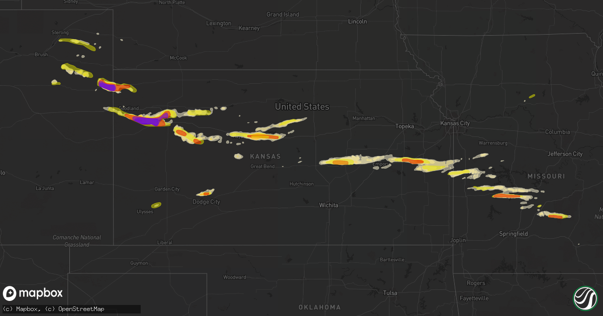
Hail Map in Kansas on May 25, 2017
Get this storm
May 25 map
$229
one time, instant access
Download today. No call, no setup
Keep the $229
Bought the map and want the full workflow? Apply the entire $229 to a subscription within 7 days. None of it is wasted.
Every map, not just this one
This buys you this map. Subscription and you get every map we run, in the markets you choose from a few cities to whole states to nationwide. Plus real-time alerts the moment a storm fires.
Contact data
Name, contact info, occupancy, even credit band for addresses in the footprint. You go from where it hit to who to call.
Become the source they trust
Unlimited branding weather history reports on demand. You already have the documented answer ready for the property owner, and you are the one who showed up with it.
Property data and RoofTrace estimates
Pull up any address you have got, its value and the exact code rules for that jurisdiction, straight from One Click Code. Then RoofTrace estimates the squares, pitch, and roof value, priced the way you price.
Storm reports in Kansas
Kansas
| Date | Description |
|---|---|
| 05/25/20176:45 PM CDT | Public report via social media of wind damage. Flag pole snapped in half... Two wind chimes lost... And a couple of downed trees. |
| 05/25/20176:45 PM CDT | Koel site reported a wind gust of 68 mph. |
| 05/25/20176:22 PM CDT | Morton machinery building blown down on cr 430 between cr zest and cr apache acre. Estimated time of report from radar |
| 05/25/20176:20 PM CDT | A local report indicates 1.00 inch wind near 10 NNE HICKOK |
| 05/25/20176:17 PM CDT | Terrible straightline winds broke tree limbs. Reported 3/4 mile s of cr zest on cr 400. Estimated time of report from radar. |
| 05/25/20176:00 PM CDT | Wind damage reported via social media by public. Many trees blown down and shingles blown off of roof. |
| 05/25/20175:56 PM CDT | A local report indicates 1.75 inch wind near 8 NW WINONA |
| 05/25/20175:48 PM CDT | Occurred with baseball size hail. Reported on cr 29 .3 miles north of county line. |
| 05/25/20175:48 PM CDT | Occurred with 80 mph winds reported on cr 29 roughly .3 miles north of county line. |
| 05/25/20175:22 PM CDT | A local report indicates 1.50 inch wind near 10 S GOODLAND |
| 05/25/20175:18 PM CDT | A local report indicates 1.00 inch wind near 7 S RULETON |
| 05/25/20172:55 AM CDT | A local report indicates 1.75 inch wind near 4 SW PRINCETON |
| 05/25/20172:35 AM CDT | A local report indicates 1.00 inch wind near 3 S MELVERN |
| 05/25/20171:37 AM CDT | Report received via social media. |
| 05/24/201710:06 PM CDT | Trained spotter estimates 60 to 70 mph winds which was breaking off branches of unknown size. |
| 05/24/20179:42 PM CDT | Report of 2 and a quarter inch hail on the east side of town. |
| 05/24/20179:37 PM CDT | A local report indicates 66 MPH wind near RUSSELL AIRPORT |
| 05/24/20179:28 PM CDT | Report of hail falling along the interstate. Time is approximated from radar. |
| 05/24/20179:22 PM CDT | Time is based on radar. |
| 05/24/20178:56 PM CDT | This was at the hays airport. |
| 05/24/20178:52 PM CDT | A local report indicates 1.00 inch wind near 1 ENE YOCEMENTO |
| 05/24/20178:48 PM CDT | This report is from the ksu mesonet. |
| 05/24/20178:25 PM CDT | Grain bin was report blown over and in the middle of the road south of morland. Also... Reports of watrer crossing the road in the same area. |
| 05/24/20178:22 PM CDT | A local report indicates 70 MPH wind near 2 E BROWNELL |
| 05/24/20178:22 PM CDT | A local report indicates 58 MPH wind near 4 NNW MCCRACKEN |
| 05/24/20178:16 PM CDT | A local report indicates 60 MPH wind near 4 W BROWNELL |
| 05/24/20178:05 PM CDT | Report of power line blown down in quinter. |
| 05/24/20178:00 PM CDT | A local report indicates 59 MPH wind near TREGO CENTER |
| 05/24/20178:00 PM CDT | A local report indicates 65 MPH wind near 2 S TREGO CENTER |
| 05/24/20177:57 PM CDT | A local report indicates 65 MPH wind near 2 S TREGO CENTER |
| 05/24/20177:49 PM CDT | This is a correction from yesterdays hail report for this location. |
| 05/24/20177:10 PM CDT | Metal shed blown down. Broken power poll. Number of trees blown down including one that was 30 feet tall. |
| 05/24/20177:07 PM CDT | Measured wind gust of 71 mph from mesonet site in gove city. |
All States Impacted by Hail Map on May 25, 2017
Cities Impacted by Hail Map on May 25, 2017
- Emporia, KS
- Penokee, KS
- Hoxie, KS
- Morland, KS
- Bath, NC
- Pinetown, NC
- Belhaven, NC
- Pantego, NC
- Edson, KS
- Winona, KS
- Gove, KS
- Quinter, KS
- Saint Francis, KS
- Wray, CO
- Idalia, CO
- Dodge City, KS
- Jetmore, KS
- Little River, KS
- Louisburg, NC
- Hollywood, MD
- Avenue, MD
- Loveville, MD
- Broomes Island, MD
- Saint Leonard, MD
- Clements, MD
- Leonardtown, MD
- Mechanicsville, MD
- Woodstock, MD
- Owings Mills, MD
- Randallstown, MD
- La Cygne, KS
- Fontana, KS
- Edinburg, VA
- Fort Valley, VA
- Wheatland, MO
- Hermitage, MO
- Waverly, KS
- Lebo, KS
- Richmond, KS
- Melvern, KS
- Williamsburg, KS
- Princeton, KS
- Centreville, MD
- Church Hill, MD
- Pittsburg, MO
- Flemington, MO
- Collins, MO
- Weaubleau, MO
- Ellis, KS
- Hays, KS
- Lehigh, KS
- Marion, KS
- Hillsboro, KS
- Tampa, KS
- Pleasanton, KS
- Amoret, MO
- Appleton City, MO
- Butler, MO
- Montrose, MO
- Foster, MO
- Akron, CO
- Otis, CO
- Urbana, MO
- Humansville, MO
- Colby, KS
- Oakley, KS
- Roby, MO
- Lynchburg, MO
- Falcon, MO
- Lebanon, MO
- Grovespring, MO
- Mountain Grove, MO
- Plato, MO
- Preston, MO
- Macks Creek, MO
- Greeley, KS
- Rantoul, KS
- Lane, KS
- Waldo, KS
- Barnard, KS
- Lincoln, KS
- Lucas, KS
- Russell, KS
- Minneapolis, KS
- Bunker Hill, KS
- Luray, KS
- Sylvan Grove, KS
- Americus, KS
- Rexford, KS
- Wilson, KS
- Gorham, KS
- Victoria, KS
- Dorrance, KS
- Walker, KS
- Windyville, MO
- Buffalo, MO
- Long Lane, MO
- La Crosse, KS
- Bison, KS
- Lindon, CO
- Anton, CO
- Clinton, MO
- Tunas, MO
- Yuma, CO
- Virgilina, VA
- Buffalo Junction, VA
- Nelson, VA
- El Dorado Springs, MO
- Schell City, MO
- Royal Oak, MD
- Neosho Rapids, KS
- Damar, KS
- Bogue, KS
- Conway, MO
- Fleming, CO
- Grinnell, KS
- Ogallah, KS
- Wakeeney, KS
- Oxford, MD
- Blairstown, MO
- Urich, MO
- Chilhowee, MO
- Osceola, MO
- Collyer, KS
- Eckley, CO
- Youngsville, NC
- Wake Forest, NC
- Paradise, KS
- Garnett, KS
- Shiloh, NJ
- Bridgeton, NJ
- Greenwich, NJ
- Wright, KS
- Heathsville, VA
- Reedville, VA
- Elm City, NC
- Rocky Mount, NC
- Louisburg, KS
- Sunset Beach, NC
- Louisburg, MO
- Cambridge, MD
- Trappe, MD
- Monument, KS
- Levant, KS
- Goodland, KS
- Wallace, KS
- Champion, NE
- Brunswick, MO
- Osage City, KS
- Reading, KS
- Osawatomie, KS
- Elmer, NJ
- Parker, KS
- Painter, VA
- Hacksneck, VA
- Belle Haven, VA
- Bunn, NC
- Spring Hope, NC
- Zebulon, NC
- Satanta, KS
- Ulysses, KS
- Clarksville, VA
- Windsor, MO
- Strong City, KS
- Canton, KS
- Elmdale, KS
- Durham, KS
- Lincolnville, KS
- Holyoke, CO
- Ellicott City, MD
- Park, KS
- Grainfield, KS
- Pinetops, NC
- Montreal, MO
- Camdenton, MO
- Kanorado, KS
- Wilsey, KS
- Burlington, CO
- Windom, KS
- Eldridge, MO
- Natoma, KS
- Quincy, MO
- Kirk, CO
- Drexel, MO
- Huntingtown, MD
- Prince Frederick, MD
- Phillipsburg, MO
- Centerville, KS
- Nanjemoy, MD
- Woodford, VA
- Quenemo, KS
- Amsterdam, MO
- Adrian, MO
- Paola, KS
- Bird City, KS
- Vernon, CO
- Brewster, KS
- Burdick, KS
- Galva, KS
- Massey, MD
- Townsend, DE
- Galena, MD
- Hill City, KS
- Creighton, MO
- King George, VA
- Rockville, MO
- Harwood, MO
- Mount Jackson, VA
- Admire, KS
- Lowry City, MO
- Deepwater, MO
- Boydton, VA
- Cross Timbers, MO
- Council Grove, KS
- Mound City, KS
- Westphalia, KS
- Lost Springs, KS
- Roxbury, KS
- Nashville, NC
- Haxtun, CO
- Sterling, CO
- Easton, MD
- Chestertown, MD
- Sudlersville, MD
- Willow Springs, MO
- Deal Island, MD
- Princess Anne, MD
- Supply, NC
- Garden City, MO
- Archie, MO
- Wilson, NC
- Bailey, NC
- Roach, MO
- Walker, MO
- Robbins, NC
- Waldorf, MD
- Success, MO
- Chase City, VA
- Plainville, KS
- Chase, KS
- Pikesville, MD
- Warwick, MD
- Stockton, MO
- Salisbury, MO
- Keytesville, MO
- Utica, KS
- Pomona, KS
- Bahama, NC
- Butner, NC
- Creedmoor, NC
- Stem, NC


