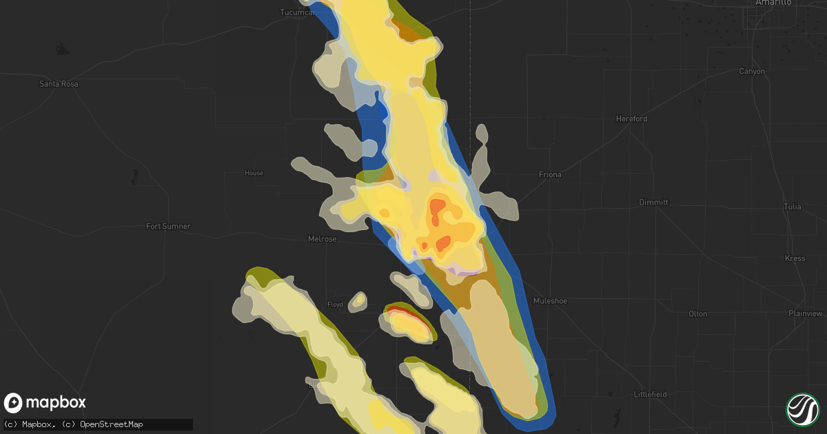
Hail Map in Clovis, NM on May 24, 2023
Get this storm
May 24 map
$229
one time, instant access
Download today. No call, no setup
Keep the $229
Bought the map and want the full workflow? Apply the entire $229 to a subscription within 7 days. None of it is wasted.
Every map, not just this one
This buys you this map. Subscription and you get every map we run, in the markets you choose from a few cities to whole states to nationwide. Plus real-time alerts the moment a storm fires.
Contact data
Name, contact info, occupancy, even credit band for addresses in the footprint. You go from where it hit to who to call.
Become the source they trust
Unlimited branding weather history reports on demand. You already have the documented answer ready for the property owner, and you are the one who showed up with it.
Property data and RoofTrace estimates
Pull up any address you have got, its value and the exact code rules for that jurisdiction, straight from One Click Code. Then RoofTrace estimates the squares, pitch, and roof value, priced the way you price.
Storm reports in Clovis, NM
Clovis, NM
| Date | Description |
|---|---|
| 05/23/202310:30 PM CDT | Report from mping: 1-inch tree limbs broken; shingles blown off. |
| 05/23/202310:09 PM CDT | Report from mping: 1-inch tree limbs broken; shingles blown off. |
| 05/23/202310:05 PM CDT | Traffic sign blown down/bent over. |
| 05/23/202310:00 PM CDT | Significant damage to a dairy... Including roof damage... Door damage and powerlines/power poles down in/around the dairy. |
| 05/23/202310:00 PM CDT | Transformer bent over county road 5. Multiple tree limbs down as well. |
| 05/23/202310:00 PM CDT | Wall collapsed on red arrow entertainment building near mitchell and 21st street due to strong winds. |
| 05/23/20239:50 PM CDT | Golf ball size hail relayed by emergency manager from public. |
| 05/23/20239:43 PM CDT | Report from mping: quarter |
| 05/23/20239:40 PM CDT | A local report indicates 60 MPH wind near 4 SW CLOVIS |
| 05/23/20239:38 PM CDT | A local report indicates 2.00 inch wind near 2 ESE PORTAIR |
| 05/23/20239:36 PM CDT | Emergency manager reported minor roof damage to home near mockingbird lane and marlene blvd. |
| 05/23/20239:30 PM CDT | A local report indicates 2.00 inch wind near 3 ENE CLOVIS |
| 05/23/20239:27 PM CDT | Wind driven golf ball size hail shattered windows of hotel. |
| 05/23/20239:27 PM CDT | A local report indicates 1.00 inch wind near 4 N CLOVIS |
| 05/23/20239:21 PM CDT | Wind driven hail. |
| 05/23/20239:20 PM CDT | Emergency manager reported roof damage to townhome/duplex near n main and e tierra blanca road. |
| 05/23/20239:15 PM CDT | Report from mping: quarter |
| 05/23/20239:14 PM CDT | 21st street and echols. |
| 05/23/20239:10 PM CDT | Curry road p and navajo road. |
| 05/23/20239:05 PM CDT | A local report indicates 1.00 inch wind near 6 N CLOVIS |
| 05/23/20239:00 PM CDT | A local report indicates 1.75 inch wind near 3 WNW RANCHVALE |
| 05/23/20238:47 PM CDT | A local report indicates 60 MPH wind near 4 SE CANNON AIR FORCE B |
| 05/23/20238:30 PM CDT | Rain wrapped tornado. |
| 05/23/20238:23 PM CDT | Measured with handheld. |
All States Impacted by Hail Map on May 24, 2023
All Cities Impacted by Hail Map on May 24, 2023
- Talpa, TX
- Melvin, TX
- Eden, TX
- Rotan, TX
- Dickens, TX
- Roby, TX
- Voss, TX
- Nowata, OK
- Coleman, TX
- Heber City, UT
- Parker, CO
- Castle Rock, CO
- Grantsville, UT
- Grouse Creek, UT
- Battle Mountain, NV
- Spring Creek, NV
- Aurora, CO
- Folsom, NM
- Walsenburg, CO
- Rye, CO
- Belle Glade, FL
- Colorado Springs, CO
- Bennett, CO
- Murtaugh, ID
- Burley, ID
- Rockland, ID
- Largo, FL
- Seminole, FL
- Pinellas Park, FL
- Loxahatchee, FL
- South Bay, FL
- Pueblo, CO
- Agate, CO
- Deer Trail, CO
- Admire, KS
- Emporia, KS
- Wagon Mound, NM
- Dugway, UT
- Alpine, TX
- Fort Davis, TX
- Marathon, TX
- Tremonton, UT
- Heyburn, ID
- Paul, ID
- Rupert, ID
- Declo, ID
- Malta, ID
- Malta, MT
- Avondale, CO
- Ocate, NM
- Pocatello, ID
- Lodge Grass, MT
- Conchas Dam, NM
- Jordan, MT
- Fort Peck, MT
- Rocky Ford, CO
- Rush, CO
- Yoder, CO
- Kansas City, MO
- Sugar City, CO
- La Junta, CO
- Sedan, NM
- Clayton, NM
- Talmage, UT
- Laramie, WY
- Wiggins, CO
- Kiowa, CO
- Florissant, CO
- Sedalia, CO
- Larkspur, CO
- Hartford, KS
- Madison, KS
- Gridley, KS
- Crescent Valley, NV
- Wetmore, CO
- Ramah, CO
- Beulah, CO
- Homosassa, FL
- Cohagen, MT
- Clewiston, FL
- Arcadia, FL
- Cheyenne, WY
- Kim, CO
- Raton, NM
- Boynton Beach, FL
- De Witt, MO
- Carrollton, MO
- Eureka, NV
- Howard, KS
- Fall River, KS
- Versailles, MO
- Stover, MO
- Las Animas, CO
- Iola, KS
- Saint Petersburg, FL
- Copan, OK
- Dewey, OK
- Wann, OK
- Hazelton, ID
- Hansen, ID
- Limon, CO
- Matheson, CO
- Delaware, OK
- Lenapah, OK
- Sarasota, FL
- Okeechobee, FL
- Clearwater, FL
- Franklin, LA
- Lake Worth, FL
- Calhan, CO
- Grass Range, MT
- Longton, KS
- Dulac, LA
- Humboldt, TN
- Daniel, WY
- Des Moines, NM
- Bartow, FL
- Fort Meade, FL
- Jupiter, FL
- Felda, FL
- Labelle, FL
- Trenton, TN
- Milan, TN
- Las Vegas, NM
- Simla, CO
- Tabiona, UT
- Hanna, UT
- Delray Beach, FL
- Maxwell, NM
- Paola, KS
- Osawatomie, KS
- Palm Beach Gardens, FL
- Fontana, KS
- San Jon, NM
- Tucumcari, NM
- Grady, NM
- Pyote, TX
- Monahans, TX
- Wink, TX
- Bard, NM
- Broadview, NM
- Mcalister, NM
- Texico, NM
- Perryton, TX
- Spearman, TX
- Miles City, MT
- Kinsey, MT
- Hugoton, KS
- Tyrone, OK
- Hooker, OK
- Clovis, NM
- Bovina, TX
- Farwell, TX
- Melrose, NM
- Cannon Afb, NM
- Portales, NM
- Muleshoe, TX
- Amarillo, TX
- Sudan, TX
- Rogers, NM
- Causey, NM
- Morton, TX
- Maple, TX
- Enochs, TX
- Floyd, NM
- Elida, NM
- Hinsdale, MT
- Volborg, MT
- Tuscumbia, MO
- Saint Elizabeth, MO
- Saco, MT
- Idaho Falls, ID
- Lees Summit, MO
- Liberal, KS
- Wheatland, WY
- Amistad, NM
- Texline, TX
- Mosquero, NM
- Jackson, TN
- Fort Morgan, CO
- American Falls, ID
- Saint Xavier, MT
- Crow Agency, MT
- Independence, MO
- Felt, OK
- Wendover, UT
- Soda Springs, ID
- Roberts, ID
- Boonville, MO
- Conception Junction, MO
- Denton, KS
- Bendena, KS
- Troy, KS
- Robinson, KS
- Kimball, NE
- Kansas City, KS
- Burns, WY
- Hillsdale, WY
- Lame Deer, MT
- Rosebud, MT
- Blue Springs, MO
- Guilford, MO
- Carr, CO
- Kit Carson, CO
- Merino, CO
- Barstow, TX
- Miami, TX
- Dayton, WY
- Wyola, MT
- Boone, CO
- Winnett, MT
- Otter, MT
- Platte City, MO
- Olney Springs, CO
- Sand Springs, MT
- Nara Visa, NM
- Waldron, MO
- Hiawatha, KS
- Everest, KS
- Atchison, KS
- Hathaway, MT
- Carlin, NV
- Karval, CO
- Carpenter, WY
- Watrous, NM
- Medina, TN
- Garryowen, MT
- Eaton, CO
- Ault, CO
- Hackberry, LA
- Vinton, LA
- Sulphur, LA
- Busby, MT
- Dalhart, TX
- Glasgow, MO
- Parkman, WY
- Briggsdale, CO
- Fort Lauderdale, FL
- Roswell, NM
- Blackfoot, ID
- Pingree, ID
- Denmark, TN
- Weldona, CO
- Orchard, CO
- Pierce, CO
- Fayette, MO
- Carey, ID
- Buckner, MO
- Acton, MT
- Whiteface, TX
- Friona, TX
- Hereford, TX
- Summerfield, TX
- Dimmitt, TX
- Earth, TX
- Amherst, TX
- Littlefield, TX
- Fieldton, TX
- Anton, TX
- Levelland, TX
- Shallowater, TX
- Lubbock, TX
- Pep, NM
- Willow, OK
- Tokio, TX
- Meadow, TX
- Brownfield, TX
- Crossroads, NM
- Milnesand, NM
- Tatum, NM
- Seagraves, TX
- Plains, TX
- Welch, TX
- Odonnell, TX
- Denver City, TX
- Lamesa, TX
- Seminole, TX
- Loop, TX
- Canadian, TX
- Syracuse, KS
- Gate, OK
- Booker, TX
- Goodwell, OK
- Stratford, TX
- Texhoma, TX
- Texhoma, OK
- Gruver, TX
- Lamar, CO
- Turpin, OK
- Haswell, CO
- Dix, NE
- Tarzan, TX
- Mangum, OK
- Forsyth, MT
- Erick, OK
- Tahoka, TX
- Wilson, TX
- Big Spring, TX


