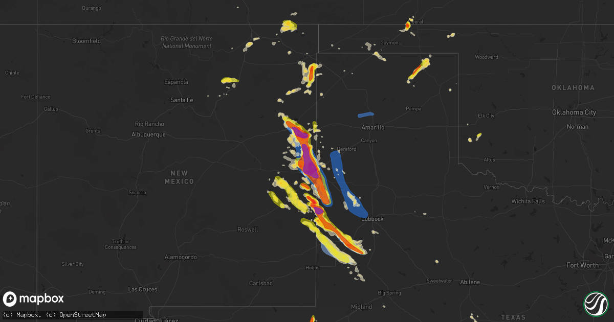
Hail Map on May 24, 2023
Get this storm
May 24 map
$229
one time, instant access
Download today. No call, no setup
Keep the $229
Bought the map and want the full workflow? Apply the entire $229 to a subscription within 7 days. None of it is wasted.
Every map, not just this one
This buys you this map. Subscription and you get every map we run, in the markets you choose from a few cities to whole states to nationwide. Plus real-time alerts the moment a storm fires.
Contact data
Name, contact info, occupancy, even credit band for addresses in the footprint. You go from where it hit to who to call.
Become the source they trust
Unlimited branding weather history reports on demand. You already have the documented answer ready for the property owner, and you are the one who showed up with it.
Property data and RoofTrace estimates
Pull up any address you have got, its value and the exact code rules for that jurisdiction, straight from One Click Code. Then RoofTrace estimates the squares, pitch, and roof value, priced the way you price.
States Impacted by Hail Map on May 24, 2023
Storm reports
Wyoming
| Date | Description |
|---|---|
| 05/24/20236:38 PM CDT | Numerous photos and videos of a brief landspout tornado over cheyenne airport...or just south of dell range blvd. Laramie county emergency management reported no damage |
Colorado
| Date | Description |
|---|---|
| 05/24/20235:30 PM CDT | A local report indicates 1.00 inch wind near 5 NNE PUEBLO WEST |
| 05/24/20235:10 PM CDT | A local report indicates 1.00 inch wind near PUEBLO WEST |
| 05/24/20234:27 PM CDT | A local report indicates 1.50 inch wind near 12 NE COLORADO CITY |
| 05/24/20233:14 PM CDT | A local report indicates 1.00 inch wind near PARKER |
| 05/24/20232:52 PM CDT | Delayed report. Spotter reported dime to half dollar sized hail. Time estimated by radar. |
| 05/23/20237:27 PM CDT | Briefly touched down crossing highway 71. |
Montana
| Date | Description |
|---|---|
| 05/24/20236:50 PM CDT | A local report indicates 1.00 inch wind near HATHAWAY |
| 05/24/20236:11 PM CDT | A local report indicates 2.75 inch wind near LAME DEER |
| 05/23/20237:45 PM CDT | A local report indicates 1.00 inch wind near 8 NNW MILES CITY |
| 05/23/20237:32 PM CDT | Estimated one inch of rain in 30 minutes. |
Florida
| Date | Description |
|---|---|
| 05/24/20233:54 PM CDT | Earth networks mesonet bllgl glades central community high school reported a wind gust of 62 mph at 4:54 pm as a severe thunderstorm moved through the area. |
| 05/24/20233:30 PM CDT | Hendry county em advises of a local storm report in clewiston. Caller states that roof damage occurred at clewiston nursing and rehabilitation center due to thunderstor |
| 05/24/20233:00 PM CDT | Broadcast meteorologist shared via social media... Several trees down on the street as well as fence damage in northern clewiston near ponce de leon avenue. Radar estim |
| 05/24/20232:59 PM CDT | Ham radio operator passed along a report from a trained weather spotter of a large tree and powerlines down on lantana road just east of the intersection with jog road. |
| 05/24/20232:54 PM CDT | Metal donation clothing box blown into w c owen avenue in clewiston as a strong thunderstorm moved through the area. Radar estimated time of 3:54pm. |
| 05/24/20231:13 PM CDT | A wind gust of 58 mph or 50 kt was recorded at the juno beach pier mesonet. |
Texas
| Date | Description |
|---|---|
| 05/24/20233:46 AM CDT | Mesonet station 15 seagraves 1sw. |
| 05/24/20233:11 AM CDT | West texas mesonet. |
| 05/24/20233:05 AM CDT | Large quantities of accumulating hail up to quarter size. |
| 05/24/20232:27 AM CDT | West texas mesonet. |
| 05/24/20232:16 AM CDT | Delayed report. Public estimated golf ball size hail before leading edge of bow echo hit. Time estimated by radar. |
| 05/24/20232:16 AM CDT | Delayed report of wind damage. Speed unknown. Time estimated by radar. |
| 05/24/202312:53 AM CDT | A local report indicates 61 MPH wind near ANTON |
| 05/24/202312:53 AM CDT | West texas mesonet. Additional gusts of 59 to 60 mph measured between 12:48 am and 1:04 am. |
| 05/24/202312:38 AM CDT | Several trees blown down in anton. Power was also knocked out for several hours. Time estimated from radar. |
| 05/24/202312:38 AM CDT | Delayed report: several trees blown down in anton. Power was also knocked out for several hours. Time estimated from radar. |
| 05/24/202312:35 AM CDT | Delayed report: power poles blown down. Community of whitharral reported to be without power. Time estimated from radar. |
| 05/24/202312:35 AM CDT | Power poles blown down. Community of whitharral reported to be without power. Time estimated from radar. |
| 05/23/202311:59 PM CDT | Report of ping pong size golf ball on twitter. |
| 05/23/202311:59 PM CDT | Report of golf ball size hail on twitter. |
| 05/23/202310:25 PM CDT | Delayed report of hail near ping pong ball size. Time estimated by radar. |
| 05/23/202310:06 PM CDT | West texas mesonet measured several severe gusts between 59 and 67 mph... Starting at 9:59 pm and continuing through 10:09 pm. |
| 05/23/202310:05 PM CDT | West texas mesonet measured several severe gusts between 59 and 64 mph... Starting at 9:59 pm and continuing through the current time of 10:05 pm. |
| 05/23/20239:42 PM CDT | Delayed report. Time estimated by radar. |
| 05/23/20239:20 PM CDT | Observed by mesonet. |
| 05/23/20239:01 PM CDT | Observed by mesonet. |
| 05/23/20238:00 PM CDT | A local report indicates 59 MPH wind near GLENRIO |
| 05/23/20237:31 PM CDT | Winkler co. Emc reports golf ball size hail at 113 airport rd in wink. |
| 05/23/20237:18 PM CDT | Spotter relayed report from son of golf ball size hail 7 miles south of wink. |
Oklahoma
| Date | Description |
|---|---|
| 05/23/20238:40 PM CDT | Corrects previous hail report from tyrone. Estimated report from trained spotter of golf ball sized hail and 45-50 mph winds in tyrone... Ok around 8:40 pm. Hail lasted |
Nevada
| Date | Description |
|---|---|
| 05/24/20234:30 PM CDT | Hail covering i-80 seen from ndot camera at emigrant pass. Report from travelers that hail sounded like a shotgun when hitting vehicle. |
| 05/24/20234:00 PM CDT | Confirmed tornados on ground from public sources. Two separate tornados in sequence from same supercell. |
| 05/24/20233:46 PM CDT | Public photos of 1.25 to 1.5 inch hail. |
| 05/24/20233:40 PM CDT | First tornado as reported in public photos. |
| 05/24/20233:40 PM CDT | Photo of 1.25 to 1.5 inch hail against ruler. |
| 05/24/20233:00 PM CDT | Public report of 1.25 to 1.5 inch hail. |
Kansas
| Date | Description |
|---|---|
| 05/24/20234:17 PM CDT | Relayed via kvoe radio. |
| 05/23/20238:22 PM CDT | Corrects previous hail report from 10 s woods. Time est from radar. |
| 05/23/20238:18 PM CDT | A local report indicates 1.00 inch wind near 10 S WOODS |
| 05/23/20237:45 PM CDT | A local report indicates 1.25 inch wind near 2 SSE LEONA |
Utah
| Date | Description |
|---|---|
| 05/24/20233:20 PM CDT | Public video of multiple hailstones approximately half dollar size. Time estimated by radar. |
| 05/24/20231:37 PM CDT | Corrected location |
| 05/24/20231:37 PM CDT | A local report indicates 1.00 inch wind near STRAWBERRY RES |
New Mexico
| Date | Description |
|---|---|
| 05/24/20236:59 PM CDT | A local report indicates 2.00 inch wind near 3 W SAN JON |
| 05/24/20236:57 PM CDT | Report from mping: golf ball |
| 05/24/20236:55 PM CDT | A local report indicates 1.75 inch wind near 4 NW SEDAN |
| 05/24/20236:54 PM CDT | . |
| 05/24/20236:54 PM CDT | A local report indicates 2.00 inch wind near 5 NW SAN JON |
| 05/24/20236:45 PM CDT | Hail between half inch and ping pong balls lasted around 45 minutes. Significant accumulation. |
| 05/24/20236:42 PM CDT | Asos station ktcc tucumcari muni airport. |
| 05/24/20236:41 PM CDT | Report from mping: quarter |
| 05/24/20236:41 PM CDT | Report from mping: quarter |
| 05/23/202311:15 PM CDT | Most hail was pea to nickel size but got a few golf ball size hailstones as well. |
| 05/23/202310:40 PM CDT | A local report indicates 1.50 inch wind near 1 NNE PORTALES |
| 05/23/202310:38 PM CDT | Report from mping: ping pong ball |
| 05/23/202310:35 PM CDT | Report from mping: golf ball |
| 05/23/202310:30 PM CDT | Report from mping: 1-inch tree limbs broken; shingles blown off. |
| 05/23/202310:25 PM CDT | Hail busted out windows on the southside of most buildings in town. |
| 05/23/202310:09 PM CDT | Report from mping: 1-inch tree limbs broken; shingles blown off. |
| 05/23/202310:05 PM CDT | Traffic sign blown down/bent over. |
| 05/23/202310:00 PM CDT | Transformer bent over county road 5. Multiple tree limbs down as well. |
| 05/23/202310:00 PM CDT | Significant damage to a dairy... Including roof damage... Door damage and powerlines/power poles down in/around the dairy. |
| 05/23/202310:00 PM CDT | Wall collapsed on red arrow entertainment building near mitchell and 21st street due to strong winds. |
| 05/23/20239:50 PM CDT | Golf ball size hail relayed by emergency manager from public. |
| 05/23/20239:43 PM CDT | Measured with calipers. |
| 05/23/20239:43 PM CDT | Report from mping: quarter |
| 05/23/20239:43 PM CDT | Corrects previous hail report from 4 n texico. Measured with calipers. |
| 05/23/20239:42 PM CDT | Us 84 and garwood st. |
| 05/23/20239:40 PM CDT | A local report indicates 60 MPH wind near 4 SW CLOVIS |
| 05/23/20239:38 PM CDT | A local report indicates 2.00 inch wind near 2 ESE PORTAIR |
| 05/23/20239:38 PM CDT | Asos station kcvs cannon air force base. |
| 05/23/20239:36 PM CDT | Emergency manager reported minor roof damage to home near mockingbird lane and marlene blvd. |
| 05/23/20239:30 PM CDT | A local report indicates 2.00 inch wind near 3 ENE CLOVIS |
| 05/23/20239:27 PM CDT | Wind driven golf ball size hail shattered windows of hotel. |
| 05/23/20239:27 PM CDT | A local report indicates 1.00 inch wind near 4 N CLOVIS |
| 05/23/20239:21 PM CDT | Wind driven hail. |
| 05/23/20239:20 PM CDT | Emergency manager reported roof damage to townhome/duplex near n main and e tierra blanca road. |
| 05/23/20239:15 PM CDT | Report from mping: quarter |
| 05/23/20239:14 PM CDT | 21st street and echols. |
| 05/23/20239:10 PM CDT | Curry road p and navajo road. |
| 05/23/20239:05 PM CDT | A local report indicates 1.00 inch wind near 6 N CLOVIS |
| 05/23/20239:00 PM CDT | A local report indicates 1.75 inch wind near 3 WNW RANCHVALE |
| 05/23/20238:47 PM CDT | A local report indicates 60 MPH wind near 4 SE CANNON AIR FORCE B |
| 05/23/20238:30 PM CDT | Rain wrapped tornado. |
| 05/23/20238:23 PM CDT | Measured with handheld. |
| 05/23/20238:13 PM CDT | Torus mobile mesonet clocked 92.4 mph from rfd. |
| 05/23/20238:12 PM CDT | Report from mping: hen egg |
| 05/23/20238:10 PM CDT | Northside windows of baptist church knocked out. |
| 05/23/20238:00 PM CDT | A local report indicates a tornado near 3 ENE GRADY |
| 05/23/20237:52 PM CDT | A local report indicates 1.00 inch wind near 5 N GLENRIO |
| 05/23/20237:49 PM CDT | Brief tornado near the quay/curry county line. |
| 05/23/20237:46 PM CDT | A local report indicates 1.00 inch wind near 2 NW GLENRIO |
| 05/23/20237:30 PM CDT | A local report indicates 59 MPH wind near 5 NW GLENRIO |
| 05/23/20237:26 PM CDT | A local report indicates 1.25 inch wind near 6 E BARD |
| 05/23/20237:24 PM CDT | A local report indicates 2.00 inch wind near 3 SE SAN JON |
| 05/23/20237:18 PM CDT | A local report indicates 70 MPH wind near 6 N WHEATLAND |
| 05/23/20237:18 PM CDT | A local report indicates 1.00 inch wind near 6 N WHEATLAND |
| 05/23/20237:15 PM CDT | A local report indicates 2.00 inch wind near 3 WNW SAN JON |
| 05/23/20237:00 PM CDT | Multiple semi rollovers along i-40. Location estimated. |
Idaho
| Date | Description |
|---|---|
| 05/24/20235:03 PM CDT | . |
| 05/24/20235:03 PM CDT | A local report indicates 1.75 inch wind near 2 NE BURLEY |
| 05/24/20234:55 PM CDT | . |
| 05/24/20234:55 PM CDT | A local report indicates 1.75 inch wind near BURLEY |
| 05/24/20234:52 PM CDT | A local report indicates 1.00 inch wind near 1 NE RUPERT |
| 05/24/20234:40 PM CDT | A local report indicates 1.00 inch wind near POCATELLO |
| 05/24/20234:36 PM CDT | Corrects previous hail report from burley. |
| 05/24/20234:30 PM CDT | Corrects previous hail report from heyburn. |
| 05/24/20234:30 PM CDT | Extensive wheat and beet crop damage reported due to shredding of vegetation by large hailstones. Golf ball hail had been reported in the area as well. |
| 05/24/20234:30 PM CDT | A local report indicates 1.00 inch wind near 1 SE POCATELLO |
| 05/24/20234:30 PM CDT | Large hail did significant damage to awning. Photos provided through social media. |
| 05/23/20239:20 PM CDT | Thunderstorm wind snapped irrigation pivot in two. |
Cities Impacted by Hail Map on May 24, 2023
- Talpa, TX
- Melvin, TX
- Eden, TX
- Rotan, TX
- Dickens, TX
- Roby, TX
- Voss, TX
- Nowata, OK
- Coleman, TX
- Heber City, UT
- Parker, CO
- Castle Rock, CO
- Grantsville, UT
- Grouse Creek, UT
- Battle Mountain, NV
- Spring Creek, NV
- Aurora, CO
- Folsom, NM
- Walsenburg, CO
- Rye, CO
- Belle Glade, FL
- Colorado Springs, CO
- Bennett, CO
- Murtaugh, ID
- Burley, ID
- Rockland, ID
- Largo, FL
- Seminole, FL
- Pinellas Park, FL
- Loxahatchee, FL
- South Bay, FL
- Pueblo, CO
- Agate, CO
- Deer Trail, CO
- Admire, KS
- Emporia, KS
- Wagon Mound, NM
- Dugway, UT
- Alpine, TX
- Fort Davis, TX
- Marathon, TX
- Tremonton, UT
- Heyburn, ID
- Paul, ID
- Rupert, ID
- Declo, ID
- Malta, ID
- Malta, MT
- Avondale, CO
- Ocate, NM
- Pocatello, ID
- Lodge Grass, MT
- Conchas Dam, NM
- Jordan, MT
- Fort Peck, MT
- Rocky Ford, CO
- Rush, CO
- Yoder, CO
- Kansas City, MO
- Sugar City, CO
- La Junta, CO
- Sedan, NM
- Clayton, NM
- Talmage, UT
- Laramie, WY
- Wiggins, CO
- Kiowa, CO
- Florissant, CO
- Sedalia, CO
- Larkspur, CO
- Hartford, KS
- Madison, KS
- Gridley, KS
- Crescent Valley, NV
- Wetmore, CO
- Ramah, CO
- Beulah, CO
- Homosassa, FL
- Cohagen, MT
- Clewiston, FL
- Arcadia, FL
- Cheyenne, WY
- Kim, CO
- Raton, NM
- Boynton Beach, FL
- De Witt, MO
- Carrollton, MO
- Eureka, NV
- Howard, KS
- Fall River, KS
- Versailles, MO
- Stover, MO
- Las Animas, CO
- Iola, KS
- Saint Petersburg, FL
- Copan, OK
- Dewey, OK
- Wann, OK
- Hazelton, ID
- Hansen, ID
- Limon, CO
- Matheson, CO
- Delaware, OK
- Lenapah, OK
- Sarasota, FL
- Okeechobee, FL
- Clearwater, FL
- Franklin, LA
- Lake Worth, FL
- Calhan, CO
- Grass Range, MT
- Longton, KS
- Dulac, LA
- Humboldt, TN
- Daniel, WY
- Des Moines, NM
- Bartow, FL
- Fort Meade, FL
- Jupiter, FL
- Felda, FL
- Labelle, FL
- Trenton, TN
- Milan, TN
- Las Vegas, NM
- Simla, CO
- Tabiona, UT
- Hanna, UT
- Delray Beach, FL
- Maxwell, NM
- Paola, KS
- Osawatomie, KS
- Palm Beach Gardens, FL
- Fontana, KS
- San Jon, NM
- Tucumcari, NM
- Grady, NM
- Pyote, TX
- Monahans, TX
- Wink, TX
- Bard, NM
- Broadview, NM
- Mcalister, NM
- Texico, NM
- Perryton, TX
- Spearman, TX
- Miles City, MT
- Kinsey, MT
- Hugoton, KS
- Tyrone, OK
- Hooker, OK
- Clovis, NM
- Bovina, TX
- Farwell, TX
- Melrose, NM
- Cannon Afb, NM
- Portales, NM
- Muleshoe, TX
- Amarillo, TX
- Sudan, TX
- Rogers, NM
- Causey, NM
- Morton, TX
- Maple, TX
- Enochs, TX
- Floyd, NM
- Elida, NM
- Hinsdale, MT
- Volborg, MT
- Tuscumbia, MO
- Saint Elizabeth, MO
- Saco, MT
- Idaho Falls, ID
- Lees Summit, MO
- Liberal, KS
- Wheatland, WY
- Amistad, NM
- Texline, TX
- Mosquero, NM
- Jackson, TN
- Fort Morgan, CO
- American Falls, ID
- Saint Xavier, MT
- Crow Agency, MT
- Independence, MO
- Felt, OK
- Wendover, UT
- Soda Springs, ID
- Roberts, ID
- Boonville, MO
- Conception Junction, MO
- Denton, KS
- Bendena, KS
- Troy, KS
- Robinson, KS
- Kimball, NE
- Kansas City, KS
- Burns, WY
- Hillsdale, WY
- Lame Deer, MT
- Rosebud, MT
- Blue Springs, MO
- Guilford, MO
- Carr, CO
- Kit Carson, CO
- Merino, CO
- Barstow, TX
- Miami, TX
- Dayton, WY
- Wyola, MT
- Boone, CO
- Winnett, MT
- Otter, MT
- Platte City, MO
- Olney Springs, CO
- Sand Springs, MT
- Nara Visa, NM
- Waldron, MO
- Hiawatha, KS
- Everest, KS
- Atchison, KS
- Hathaway, MT
- Carlin, NV
- Karval, CO
- Carpenter, WY
- Watrous, NM
- Medina, TN
- Garryowen, MT
- Eaton, CO
- Ault, CO
- Hackberry, LA
- Vinton, LA
- Sulphur, LA
- Busby, MT
- Dalhart, TX
- Glasgow, MO
- Parkman, WY
- Briggsdale, CO
- Fort Lauderdale, FL
- Roswell, NM
- Blackfoot, ID
- Pingree, ID
- Denmark, TN
- Weldona, CO
- Orchard, CO
- Pierce, CO
- Fayette, MO
- Carey, ID
- Buckner, MO
- Acton, MT
- Whiteface, TX
- Friona, TX
- Hereford, TX
- Summerfield, TX
- Dimmitt, TX
- Earth, TX
- Amherst, TX
- Littlefield, TX
- Fieldton, TX
- Anton, TX
- Levelland, TX
- Shallowater, TX
- Lubbock, TX
- Pep, NM
- Willow, OK
- Tokio, TX
- Meadow, TX
- Brownfield, TX
- Crossroads, NM
- Milnesand, NM
- Tatum, NM
- Seagraves, TX
- Plains, TX
- Welch, TX
- Odonnell, TX
- Denver City, TX
- Lamesa, TX
- Seminole, TX
- Loop, TX
- Canadian, TX
- Syracuse, KS
- Gate, OK
- Booker, TX
- Goodwell, OK
- Stratford, TX
- Texhoma, TX
- Texhoma, OK
- Gruver, TX
- Lamar, CO
- Turpin, OK
- Haswell, CO
- Dix, NE
- Tarzan, TX
- Mangum, OK
- Forsyth, MT
- Erick, OK
- Tahoka, TX
- Wilson, TX
- Big Spring, TX