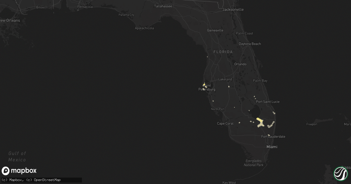
Hail Map in Florida on May 24, 2023
Get this storm
May 24 map
$229
one time, instant access
Download today. No call, no setup
Keep the $229
Bought the map and want the full workflow? Apply the entire $229 to a subscription within 7 days. None of it is wasted.
Every map, not just this one
This buys you this map. Subscription and you get every map we run, in the markets you choose from a few cities to whole states to nationwide. Plus real-time alerts the moment a storm fires.
Contact data
Name, contact info, occupancy, even credit band for addresses in the footprint. You go from where it hit to who to call.
Become the source they trust
Unlimited branding weather history reports on demand. You already have the documented answer ready for the property owner, and you are the one who showed up with it.
Property data and RoofTrace estimates
Pull up any address you have got, its value and the exact code rules for that jurisdiction, straight from One Click Code. Then RoofTrace estimates the squares, pitch, and roof value, priced the way you price.
Storm reports in Florida
Florida
| Date | Description |
|---|---|
| 05/24/20233:54 PM CDT | Earth networks mesonet bllgl glades central community high school reported a wind gust of 62 mph at 4:54 pm as a severe thunderstorm moved through the area. |
| 05/24/20233:30 PM CDT | Hendry county em advises of a local storm report in clewiston. Caller states that roof damage occurred at clewiston nursing and rehabilitation center due to thunderstor |
| 05/24/20233:00 PM CDT | Broadcast meteorologist shared via social media... Several trees down on the street as well as fence damage in northern clewiston near ponce de leon avenue. Radar estim |
| 05/24/20232:59 PM CDT | Ham radio operator passed along a report from a trained weather spotter of a large tree and powerlines down on lantana road just east of the intersection with jog road. |
| 05/24/20232:54 PM CDT | Metal donation clothing box blown into w c owen avenue in clewiston as a strong thunderstorm moved through the area. Radar estimated time of 3:54pm. |
| 05/24/20231:13 PM CDT | A wind gust of 58 mph or 50 kt was recorded at the juno beach pier mesonet. |
All States Impacted by Hail Map on May 24, 2023
Cities Impacted by Hail Map on May 24, 2023
- Talpa, TX
- Melvin, TX
- Eden, TX
- Rotan, TX
- Dickens, TX
- Roby, TX
- Voss, TX
- Nowata, OK
- Coleman, TX
- Heber City, UT
- Parker, CO
- Castle Rock, CO
- Grantsville, UT
- Grouse Creek, UT
- Battle Mountain, NV
- Spring Creek, NV
- Aurora, CO
- Folsom, NM
- Walsenburg, CO
- Rye, CO
- Belle Glade, FL
- Colorado Springs, CO
- Bennett, CO
- Murtaugh, ID
- Burley, ID
- Rockland, ID
- Largo, FL
- Seminole, FL
- Pinellas Park, FL
- Loxahatchee, FL
- South Bay, FL
- Pueblo, CO
- Agate, CO
- Deer Trail, CO
- Admire, KS
- Emporia, KS
- Wagon Mound, NM
- Dugway, UT
- Alpine, TX
- Fort Davis, TX
- Marathon, TX
- Tremonton, UT
- Heyburn, ID
- Paul, ID
- Rupert, ID
- Declo, ID
- Malta, ID
- Malta, MT
- Avondale, CO
- Ocate, NM
- Pocatello, ID
- Lodge Grass, MT
- Conchas Dam, NM
- Jordan, MT
- Fort Peck, MT
- Rocky Ford, CO
- Rush, CO
- Yoder, CO
- Kansas City, MO
- Sugar City, CO
- La Junta, CO
- Sedan, NM
- Clayton, NM
- Talmage, UT
- Laramie, WY
- Wiggins, CO
- Kiowa, CO
- Florissant, CO
- Sedalia, CO
- Larkspur, CO
- Hartford, KS
- Madison, KS
- Gridley, KS
- Crescent Valley, NV
- Wetmore, CO
- Ramah, CO
- Beulah, CO
- Homosassa, FL
- Cohagen, MT
- Clewiston, FL
- Arcadia, FL
- Cheyenne, WY
- Kim, CO
- Raton, NM
- Boynton Beach, FL
- De Witt, MO
- Carrollton, MO
- Eureka, NV
- Howard, KS
- Fall River, KS
- Versailles, MO
- Stover, MO
- Las Animas, CO
- Iola, KS
- Saint Petersburg, FL
- Copan, OK
- Dewey, OK
- Wann, OK
- Hazelton, ID
- Hansen, ID
- Limon, CO
- Matheson, CO
- Delaware, OK
- Lenapah, OK
- Sarasota, FL
- Okeechobee, FL
- Clearwater, FL
- Franklin, LA
- Lake Worth, FL
- Calhan, CO
- Grass Range, MT
- Longton, KS
- Dulac, LA
- Humboldt, TN
- Daniel, WY
- Des Moines, NM
- Bartow, FL
- Fort Meade, FL
- Jupiter, FL
- Felda, FL
- Labelle, FL
- Trenton, TN
- Milan, TN
- Las Vegas, NM
- Simla, CO
- Tabiona, UT
- Hanna, UT
- Delray Beach, FL
- Maxwell, NM
- Paola, KS
- Osawatomie, KS
- Palm Beach Gardens, FL
- Fontana, KS
- San Jon, NM
- Tucumcari, NM
- Grady, NM
- Pyote, TX
- Monahans, TX
- Wink, TX
- Bard, NM
- Broadview, NM
- Mcalister, NM
- Texico, NM
- Perryton, TX
- Spearman, TX
- Miles City, MT
- Kinsey, MT
- Hugoton, KS
- Tyrone, OK
- Hooker, OK
- Clovis, NM
- Bovina, TX
- Farwell, TX
- Melrose, NM
- Cannon Afb, NM
- Portales, NM
- Muleshoe, TX
- Amarillo, TX
- Sudan, TX
- Rogers, NM
- Causey, NM
- Morton, TX
- Maple, TX
- Enochs, TX
- Floyd, NM
- Elida, NM
- Hinsdale, MT
- Volborg, MT
- Tuscumbia, MO
- Saint Elizabeth, MO
- Saco, MT
- Idaho Falls, ID
- Lees Summit, MO
- Liberal, KS
- Wheatland, WY
- Amistad, NM
- Texline, TX
- Mosquero, NM
- Jackson, TN
- Fort Morgan, CO
- American Falls, ID
- Saint Xavier, MT
- Crow Agency, MT
- Independence, MO
- Felt, OK
- Wendover, UT
- Soda Springs, ID
- Roberts, ID
- Boonville, MO
- Conception Junction, MO
- Denton, KS
- Bendena, KS
- Troy, KS
- Robinson, KS
- Kimball, NE
- Kansas City, KS
- Burns, WY
- Hillsdale, WY
- Lame Deer, MT
- Rosebud, MT
- Blue Springs, MO
- Guilford, MO
- Carr, CO
- Kit Carson, CO
- Merino, CO
- Barstow, TX
- Miami, TX
- Dayton, WY
- Wyola, MT
- Boone, CO
- Winnett, MT
- Otter, MT
- Platte City, MO
- Olney Springs, CO
- Sand Springs, MT
- Nara Visa, NM
- Waldron, MO
- Hiawatha, KS
- Everest, KS
- Atchison, KS
- Hathaway, MT
- Carlin, NV
- Karval, CO
- Carpenter, WY
- Watrous, NM
- Medina, TN
- Garryowen, MT
- Eaton, CO
- Ault, CO
- Hackberry, LA
- Vinton, LA
- Sulphur, LA
- Busby, MT
- Dalhart, TX
- Glasgow, MO
- Parkman, WY
- Briggsdale, CO
- Fort Lauderdale, FL
- Roswell, NM
- Blackfoot, ID
- Pingree, ID
- Denmark, TN
- Weldona, CO
- Orchard, CO
- Pierce, CO
- Fayette, MO
- Carey, ID
- Buckner, MO
- Acton, MT
- Whiteface, TX
- Friona, TX
- Hereford, TX
- Summerfield, TX
- Dimmitt, TX
- Earth, TX
- Amherst, TX
- Littlefield, TX
- Fieldton, TX
- Anton, TX
- Levelland, TX
- Shallowater, TX
- Lubbock, TX
- Pep, NM
- Willow, OK
- Tokio, TX
- Meadow, TX
- Brownfield, TX
- Crossroads, NM
- Milnesand, NM
- Tatum, NM
- Seagraves, TX
- Plains, TX
- Welch, TX
- Odonnell, TX
- Denver City, TX
- Lamesa, TX
- Seminole, TX
- Loop, TX
- Canadian, TX
- Syracuse, KS
- Gate, OK
- Booker, TX
- Goodwell, OK
- Stratford, TX
- Texhoma, TX
- Texhoma, OK
- Gruver, TX
- Lamar, CO
- Turpin, OK
- Haswell, CO
- Dix, NE
- Tarzan, TX
- Mangum, OK
- Forsyth, MT
- Erick, OK
- Tahoka, TX
- Wilson, TX
- Big Spring, TX


