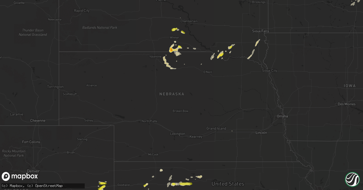
Hail Map in Nebraska on May 24, 2018
Get this storm
May 24 map
$229
one time, instant access
Download today. No call, no setup
Keep the $229
Bought the map and want the full workflow? Apply the entire $229 to a subscription within 7 days. None of it is wasted.
Every map, not just this one
This buys you this map. Subscription and you get every map we run, in the markets you choose from a few cities to whole states to nationwide. Plus real-time alerts the moment a storm fires.
Contact data
Name, contact info, occupancy, even credit band for addresses in the footprint. You go from where it hit to who to call.
Become the source they trust
Unlimited branding weather history reports on demand. You already have the documented answer ready for the property owner, and you are the one who showed up with it.
Property data and RoofTrace estimates
Pull up any address you have got, its value and the exact code rules for that jurisdiction, straight from One Click Code. Then RoofTrace estimates the squares, pitch, and roof value, priced the way you price.
Storm reports in Nebraska
Nebraska
| Date | Description |
|---|---|
| 05/24/20183:28 AM CDT | At 828 PM CDT, a severe thunderstorm was located 9 miles northwest of Johnstown, or 17 miles northwest of Ainsworth, moving southeast at 10 mph. HAZARD...60 mph wind gusts and quarter size hail. SOURCE...Radar indicated. IMPACT...Hail damage to vehicles is expected. Expect wind damage to roofs, siding, and trees. Locations impacted include... Johnstown and Wood Lake. This includes Highway 20 between mile markers 222 and 232. |
| 05/24/20182:46 AM CDT | At 745 PM CDT, a severe thunderstorm was located near Norden, or 20 miles east of Valentine, moving southeast at 15 mph. HAZARD...60 mph wind gusts and half dollar size hail. SOURCE...Radar indicated. IMPACT...Hail damage to vehicles is expected. Expect wind damage to roofs, siding, and trees. Locations impacted include... North River Trail. |
| 05/23/201811:51 PM CDT | At 451 PM CDT, a severe thunderstorm was located 10 miles south of Dante, or 19 miles southeast of Pickstown, moving northeast at 20 mph. HAZARD...60 mph wind gusts and half dollar size hail. SOURCE...Radar indicated. IMPACT...Hail damage to vehicles is expected. Expect wind damage to roofs, siding, and trees. This severe thunderstorm will be near... Dante around 515 PM CDT. Avon around 525 PM CDT. |
| 05/23/20188:00 PM CDT | Hail up to quarter size. |
All States Impacted by Hail Map on May 24, 2018
Cities Impacted by Hail Map on May 24, 2018
- Crookston, MN
- Centerville, SD
- Lennox, SD
- Bird Island, MN
- Hector, MN
- Olivia, MN
- Winona, KS
- Wallace, KS
- Wales, ND
- Alsen, ND
- Munich, ND
- Maida, ND
- Langdon, ND
- Colby, KS
- Tyndall, SD
- Marion Junction, AL
- Stratton, CO
- Winner, SD
- Colome, SD
- Dallas, SD
- Saint Charles, SD
- Bonesteel, SD
- Wayzata, MN
- Trent, TX
- Minden, NV
- Clarkfield, MN
- Minneota, MN
- Deer River, MN
- Sweetwater, TX
- International Falls, MN
- Damar, KS
- Faribault, MN
- Clinton, MN
- Fort Davis, TX
- Alpine, TX
- Haswell, CO
- Saluda, SC
- Troy, SC
- Newfolden, MN
- Thief River Falls, MN
- Goodridge, MN
- Karval, CO
- Syracuse, KS
- Kendall, KS
- Flaxton, ND
- Gardnerville, NV
- Bigfork, MN
- Hamel, MN
- Minneapolis, MN
- Long Lake, MN
- Ashford, AL
- Cottonwood, MN
- Renville, MN
- Redwood Falls, MN
- Belview, MN
- Vermillion, SD
- Gayville, SD
- Northfield, MN
- Nerstrand, MN
- Marcell, MN
- Ulysses, KS
- Hurley, WI
- Ramsay, MI
- Wakefield, MI
- Ironwood, MI
- Bessemer, MI
- Gregory, SD
- Moundville, AL
- Ainsworth, NE
- Johnstown, NE
- Catherine, AL
- Safford, AL
- Uniontown, AL
- Hill City, KS
- Penokee, KS
- Bogue, KS
- Worthing, SD
- Beresford, SD
- Presque Isle, WI
- Manitowish Waters, WI
- Bemidji, MN
- Marathon, TX
- Defuniak Springs, FL
- Titonka, IA
- Gibbon, MN
- New Ulm, MN
- Dante, SD
- Wagner, SD
- Niobrara, NE
- Avon, SD
- Hampden, ND
- Hannah, ND
- Starkweather, ND
- Waldron, AR
- Cherry Valley, AR
- Palisade, MN
- Rockford, AL
- Saint Paul, MN
- Cheyenne Wells, CO
- Oberlin, KS
- Burnsville, MN
- Savage, MN
- Rolfe, IA
- Mallard, IA
- Sparks, NE
- Bethune, CO
- Burlington, CO
- Edgefield, SC
- Warsaw, MN
- Morristown, MN
- Danube, MN
- Sacred Heart, MN
- Rib Lake, WI
- Medford, WI
- Wiggins, MS
- Kirwin, KS
- Stockton, KS
- Bowlus, MN
- Holdingford, MN
- Scotland, SD
- Olivet, SD
- Tripp, SD
- Woodruff, WI
- Red Lake Falls, MN
- Rush, CO
- Morland, KS
- Coffee Springs, AL
- Woodston, KS
- Hamlin, TX
- Sugartown, LA
- Dothan, AL
- Butternut, WI
- Granite Falls, MN
- Jordan, MN
- Prior Lake, MN
- Shakopee, MN
- Snellville, GA
- Conyers, GA
- Loganville, GA
- Glencoe, MN
- Alton, KS
- Gaylord, KS
- Samson, AL
- Boulder Junction, WI
- Saint Germain, WI
- Sayner, WI
- Brooks, MN
- Hayward, WI
- Van Horn, TX
- Beltrami, MN
- Venice, FL
- Oakley, KS
- Weogufka, AL
- Marbury, AL
- Hopkins, MN
- Eden Prairie, MN
- Tribune, KS
- Plummer, MN
- Mizpah, MN
- Glenwood, MN
- Stone Mountain, GA
- La Pine, OR
- Waterford, MS
- Springview, NE
- Littlefork, MN
- Lebanon, MO
- Phillipsburg, MO
- Emmetsburg, IA
- Cylinder, IA
- Silverstreet, SC
- Mills, NE
- Manter, KS
- Lawley, AL
- Randolph, AL
- Strathcona, MN
- Sarles, ND
- Spring Lake, MN
- Talmoon, MN
- Knapp, WI
- Dundas, MN
- Laurel Hill, FL
- Crestview, FL
- Merrill, WI
- Cass Lake, MN
- Walker, MN
- Akeley, MN
- Laporte, MN
- Trenton, FL
- Pitkin, LA
- Napoleonville, LA
- Selden, KS
- Climax, MN
- Pinellas Park, FL
- Saint Petersburg, FL
- Valentine, NE
- Earle, AR
- Norcatur, KS
- Evergreen, AL
- Ideal, SD
- Nevis, MN
- Houma, LA
- Simla, CO
- Robertsdale, AL
- New Germany, MN
- Mayer, MN
- Lester Prairie, MN
- Northport, AL
- Magee, MS
- Mount Olive, MS
- Brooklyn, MS
- Albany, MN
- Royalton, MN
- Freeport, MN
- Rocklake, ND
- Calvin, ND
- Sulphur Springs, AR
- Hill City, MN
- Swatara, MN
- Merkel, TX
- Jay, FL
- Lynch, NE
- Camden, AL
- Villard, MN
- Sugar Land, TX
- Milton, FL
- Baker, FL
- Newton, AL
- Bronson, FL
- Newberry, FL
- Volin, SD
- Coolidge, KS
- Orovada, NV
- Eads, CO
- Woodville, WI
- Baldwin, WI
- Wellington, NV
- Havelock, IA
- Laurens, IA
- Arapahoe, CO
- Mentor, MN
- Rexford, KS
- South Saint Paul, MN
- Inver Grove Heights, MN
- Bonifay, FL
- Big Falls, MN
- Montevallo, AL
- Clontarf, MN
- Danvers, MN
- Forest Home, AL
- Greenville, AL
- Sibley, IA
- Wakonda, SD
- Lonsdale, MN
- Farmington, MN
- Randolph, MN
- Kennebec, SD
- Minocqua, WI
- Lac Du Flambeau, WI
- Hamill, SD
- Kelliher, MN
- West Fork, AR
- Winslow, AR
- Fertile, MN
- Geneva, AL
- Lockport, LA
- Chancellor, AL
- Burke, SD
- Parkin, AR
- Atkinson, NE
- Holloway, MN
- Hancock, MN
- Lenora, KS
- Fenton, IA
- Buffalo Lake, MN
- Morton, MN
- Melrose, MN
- Plato, MN
- Hartford, AL
- Meridian, MS
- Cook, MN
- Beatrice, AL
- Vredenburgh, AL
- Pine Apple, AL
- Greensboro, AL
- Sylacauga, AL
- Clanton, AL
- Maplesville, AL
- Henderson, NE
- Dawson, MN
- Bassett, NE
- Glenwood City, WI
- Bowbells, ND
- Sharon Springs, KS
- Ashland, KS
- Kingfisher, OK
- Okarche, OK


