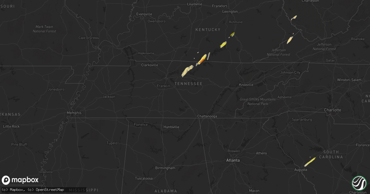
Hail Map in Tennessee on May 24, 2017
Get this storm
May 24 map
$229
one time, instant access
Download today. No call, no setup
Keep the $229
Bought the map and want the full workflow? Apply the entire $229 to a subscription within 7 days. None of it is wasted.
Every map, not just this one
This buys you this map. Subscription and you get every map we run, in the markets you choose from a few cities to whole states to nationwide. Plus real-time alerts the moment a storm fires.
Contact data
Name, contact info, occupancy, even credit band for addresses in the footprint. You go from where it hit to who to call.
Become the source they trust
Unlimited branding weather history reports on demand. You already have the documented answer ready for the property owner, and you are the one who showed up with it.
Property data and RoofTrace estimates
Pull up any address you have got, its value and the exact code rules for that jurisdiction, straight from One Click Code. Then RoofTrace estimates the squares, pitch, and roof value, priced the way you price.
Storm reports in Tennessee
Tennessee
| Date | Description |
|---|---|
| 05/24/201712:20 PM CDT | Significant damage to the poplar ridge apartments along hwy 36. Multiple trees and power lines down... Along with roof and fence damage. |
| 05/24/201711:40 AM CDT | Few trees down along the western portions of the county...east of caney branch. |
| 05/24/201711:37 AM CDT | 9 trees were blown down near hiwassee road and cedar knob lane in association with the rear flank downdraft of the ef-0 tornado to the north |
| 05/24/201711:36 AM CDT | A weak ef-0 tornado touched down in far western smith county just east of the wilson/smith county line on mitchell lane. Damage was mostly confined to dozens of trees s |
| 05/24/201711:30 AM CDT | Few trees down along the western edge of the county. |
| 05/24/201711:18 AM CDT | Numerous trees down in the edwina area. |
| 05/24/201711:18 AM CDT | Trees down in cosby and along interstate 40 at exit 440. |
| 05/24/201711:15 AM CDT | Several trees as well as power lines down on a house in the bogard community. |
| 05/24/201710:54 AM CDT | Several trees down in the great smoky mountains national park. Trees reported down in the treemont...laurel creek...and the little river between elkmont and laurel fall |
| 05/24/201710:54 AM CDT | Numerous trees down in the middle creek area. |
| 05/24/20179:05 AM CDT | Six trees down. |
All States Impacted by Hail Map on May 24, 2017
Cities Impacted by Hail Map on May 24, 2017
- Camilla, GA
- Albany, GA
- Newton, GA
- Science Hill, KY
- Nancy, KY
- Chapmanville, WV
- Lenore, WV
- Dingess, WV
- Harts, WV
- Ridge Spring, SC
- Elkhorn City, KY
- Clintwood, VA
- Haysi, VA
- Lebanon, TN
- Riddleton, TN
- Hartsville, TN
- Dixon Springs, TN
- Wadesboro, NC
- Eubank, KY
- Somerset, KY
- Alamo, GA
- Tompkinsville, KY
- Moss, TN
- Hestand, KY
- Burkesville, KY
- Celina, TN
- Aiken, SC
- Batesburg, SC
- Graniteville, SC
- Monetta, SC
- Corinne, UT
- Williamson, WV
- McRae Helena, GA
- Terrace Park, OH
- Cincinnati, OH
- Glenwood, GA
- Clarksville, OH
- Lyons, GA
- Rhine, GA
- Abbeville, GA
- Poulan, GA
- Sylvester, GA
- Sumner, GA
- Blanchester, OH
- Whitleyville, TN
- Jacksonville, GA
- Uvalda, GA
- Lumber City, GA
- Mount Vernon, GA
- Ailey, GA
- Milford, OH
- Albany, KY
- Jamestown, KY
- Red Boiling Springs, TN
- Lafayette, TN
- Pleasant Shade, TN
- Carthage, TN
- Morrow, OH
- Fitzgerald, GA
- Chula, GA
- Rebecca, GA
- Sycamore, GA
- Melbourne, KY
- North Augusta, SC
- Brodhead, KY
- Mount Vernon, KY
- Ranger, GA
- South Lebanon, OH
- Lebanon, OH
- Baconton, GA
- Big Rock, VA
- Breaks, VA
- Crab Orchard, KY
- Fedscreek, KY
- Watertown, TN
- Tifton, GA
- Ashburn, GA
- Ty Ty, GA
- Milan, GA
- Edmonton, KY
- Beaumont, KY
- Summer Shade, KY
- Orlando, FL
- Winter Park, FL
- Forsyth, GA
- Leesville, SC


