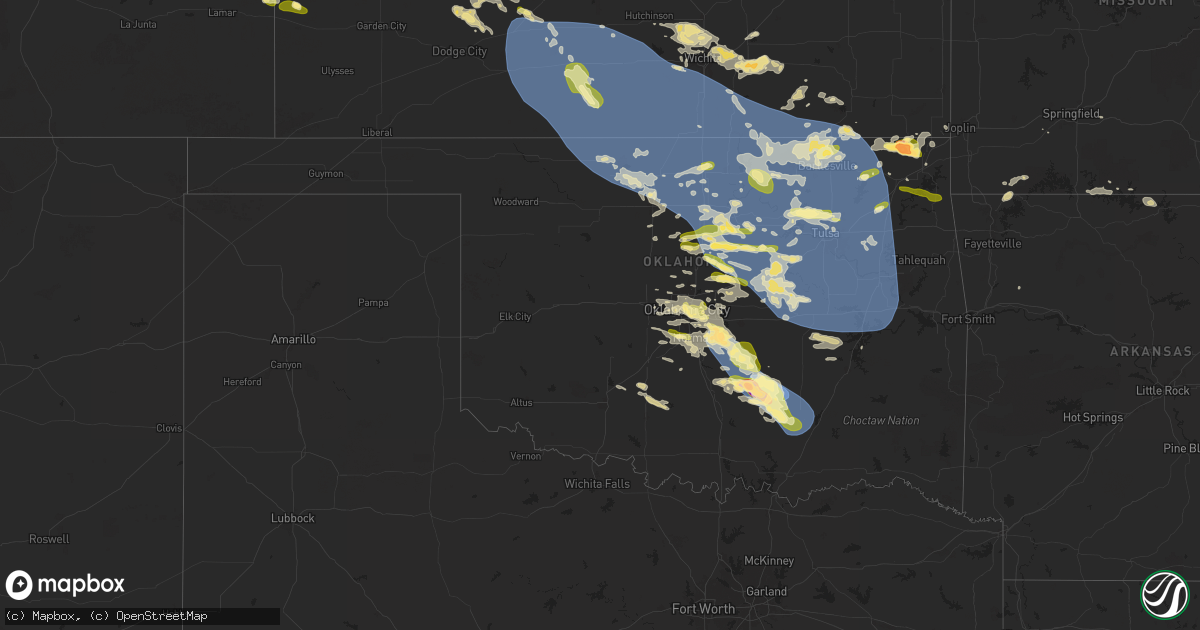
Hail Map in Oklahoma on May 23, 2025
Get this storm
May 23 map
$229
one time, instant access
Download today. No call, no setup
Keep the $229
Bought the map and want the full workflow? Apply the entire $229 to a subscription within 7 days. None of it is wasted.
Every map, not just this one
This buys you this map. Subscription and you get every map we run, in the markets you choose from a few cities to whole states to nationwide. Plus real-time alerts the moment a storm fires.
Contact data
Name, contact info, occupancy, even credit band for addresses in the footprint. You go from where it hit to who to call.
Become the source they trust
Unlimited branding weather history reports on demand. You already have the documented answer ready for the property owner, and you are the one who showed up with it.
Property data and RoofTrace estimates
Pull up any address you have got, its value and the exact code rules for that jurisdiction, straight from One Click Code. Then RoofTrace estimates the squares, pitch, and roof value, priced the way you price.
Storm reports in Oklahoma
Oklahoma
| Date | Description |
|---|---|
| 05/23/20256:44 AM CDT | Kmko measurement. |
| 05/23/20256:25 AM CDT | Power lines down. |
| 05/23/20256:20 AM CDT | (t |
| 05/23/20256:20 AM CDT | A local report indicates 65 MPH wind near 4 W Hectorville |
| 05/23/20256:20 AM CDT | A local report indicates 60 MPH wind near 1 WNW Hectorville |
| 05/23/20256:16 AM CDT | (t |
| 05/23/20256:16 AM CDT | A local report indicates 63 MPH wind near Chouteau |
| 05/23/20256:15 AM CDT | Roof off mobile home. |
| 05/23/20256:05 AM CDT | A local report indicates 60 MPH wind near 2 NE Bixby |
| 05/23/20256:05 AM CDT | Large branches down on aspen between 81st and 91st. |
| 05/23/20256:00 AM CDT | Tree limb down 75th & mingo. |
| 05/23/20255:54 AM CDT | Several large trees down. A few power lines down. |
| 05/23/20255:51 AM CDT | Large tree down blocking roadway. |
| 05/23/20255:51 AM CDT | Several large tree limbs down. |
| 05/23/20255:50 AM CDT | A local report indicates 58 MPH wind near 3 NNW Stillwater |
| 05/23/20255:45 AM CDT | A local report indicates 63 MPH wind near 4 NW Talala |
| 05/23/20255:45 AM CDT | Large tree down. Fences damaged. Several large limbs down. |
| 05/23/20255:45 AM CDT | Numerous large tree limbs down in the neighborhood. Also reported 5 to 6 minutes of hail up to dime size. Time estimated via radar. |
| 05/23/20255:38 AM CDT | Metal roof blown off munical building downtown. Several large trees down. |
| 05/23/20255:35 AM CDT | A local report indicates 64 MPH wind near Cushing |
| 05/23/20255:30 AM CDT | Numerous large trees and tree branches down across hominy. Citywide power outage as of 5:30am. |
| 05/23/20255:27 AM CDT | Numerous trees down. Roof off outbuildings. Several power lines down. |
| 05/23/20255:25 AM CDT | A local report indicates 65 MPH wind near 2 S Wynona |
| 05/23/20255:21 AM CDT | A local report indicates 73 MPH wind near 7 S Wynona |
| 05/23/20255:20 AM CDT | A local report indicates 61 MPH wind near 2 S Wynona |
| 05/23/20255:18 AM CDT | Asos station kswo stillwater. |
| 05/23/20255:10 AM CDT | A local report indicates 64 MPH wind near 3 ENE Pawnee |
| 05/23/20255:05 AM CDT | A local report indicates 58 MPH wind near 8 ESE Foraker |
| 05/23/20255:00 AM CDT | A local report indicates 61 MPH wind near 7 SW Burbank |
| 05/23/20254:58 AM CDT | Also nickel size hail. |
| 05/23/20254:55 AM CDT | A local report indicates 63 MPH wind near 7 S Red Rock |
| 05/23/20254:45 AM CDT | A local report indicates 61 MPH wind near 8 SW Hardy |
| 05/23/20254:45 AM CDT | A local report indicates 61 MPH wind near Newkirk |
| 05/23/20254:45 AM CDT | Mesonet station newk newkirk. |
| 05/23/20254:39 AM CDT | Report from mping: half dollar |
| 05/23/20254:26 AM CDT | Trained spotter measured a wind gust of 77 mph as the storm moved through ada. |
| 05/23/20254:21 AM CDT | A local report indicates 77 MPH wind near 1 W Ada |
| 05/23/20254:15 AM CDT | A local report indicates 2.00 inch wind near 4 NE Vanoss |
| 05/23/20254:12 AM CDT | Report from mping: quarter |
| 05/23/20254:00 AM CDT | Several trees down. Time estimated by radar. |
| 05/23/20253:44 AM CDT | Trees blown down over the road. |
| 05/23/20253:20 AM CDT | Report from mping: half dollar |
| 05/23/20253:15 AM CDT | Golf ball sized hail reported south of sh9 at 192nd avenue se. |
| 05/23/20253:02 AM CDT | A local report indicates 1.25 inch wind near 3 S Stillwater |
| 05/23/20252:45 AM CDT | Via social media: large tree limbs broken. |
| 05/23/20252:34 AM CDT | A local report indicates 1.00 inch wind near 2 N Norman |
| 05/23/20252:22 AM CDT | Report from mping: quarter |
| 05/23/20252:22 AM CDT | Report from mping: quarter |
| 05/23/20252:10 AM CDT | Report from mping: quarter |
| 05/23/20252:09 AM CDT | Report from mping: quarter |
| 05/23/20251:51 AM CDT | Report from mping: quarter |
| 05/23/20251:15 AM CDT | Social media picture of hailstones. |
| 05/23/20251:06 AM CDT | A local report indicates 1.25 inch wind near 4 W Norman |
| 05/23/202512:16 AM CDT | A local report indicates 1.25 inch wind near 4 N Stillwater |
| 05/23/202512:16 AM CDT | A local report indicates 1.00 inch wind near 3 NW Carney |
All States Impacted by Hail Map on May 23, 2025
Cities Impacted by Hail Map on May 23, 2025
- Medford, OK
- Lamont, OK
- Tonkawa, OK
- West Palm Beach, FL
- Perry, OK
- Blackwell, OK
- Ponca City, OK
- Wellington, FL
- Lake Worth, FL
- Indiantown, FL
- Boynton Beach, FL
- Burbank, OK
- Loxahatchee, FL
- Palm Beach Gardens, FL
- Delray Beach, FL
- Carencro, LA
- Port Saint Lucie, FL
- Sunset, LA
- Okeechobee, FL
- Boca Raton, FL
- Deerfield Beach, FL
- Balmorhea, TX
- Fort Davis, TX
- Pompano Beach, FL
- Braithwaite, LA
- Coral Springs, FL
- Fort Lauderdale, FL
- Bartlesville, OK
- Pecos, TX
- Belle Rose, LA
- Cheyenne, WY
- Owasso, OK
- Sperry, OK
- Tulsa, OK
- Saint James, LA
- Lagrange, WY
- Albin, WY
- Fort Stockton, TX
- Pembroke Pines, FL
- Hollywood, FL
- Harrisburg, NE
- Ponchatoula, LA
- Hammond, LA
- Lyman, NE
- Pyote, TX
- Barstow, TX
- Kimball, NE
- Donaldsonville, LA
- Geismar, LA
- Baton Rouge, LA
- New Raymer, CO
- Loranger, LA
- Miami Gardens, FL
- Opa Locka, FL
- Lake Worth Beach, FL
- Gering, NE
- Scottsbluff, NE
- Stoneham, CO
- Merino, CO
- Sterling, CO
- Cope, CO
- Anton, CO
- Akron, CO
- Wink, TX
- Bogalusa, LA
- Franklinton, LA
- Minatare, NE
- Bayard, NE
- Marathon, TX
- Alliance, NE
- Labelle, FL
- Baker, LA
- Montgomery, TX
- Flagler, CO
- Seibert, CO
- Hockley, TX
- Magnolia, TX
- Hemingford, NE
- Angora, NE
- Atwood, CO
- Vona, CO
- Goldsmith, TX
- Big Cabin, OK
- Vinita, OK
- Afton, OK
- Ketchum, OK
- Jay, OK
- Eucha, OK
- Saint Francisville, LA
- Moore Haven, FL
- Brooklyn, MS
- New Augusta, MS
- Grove, OK
- Yuma, CO
- Lumberton, MS
- Columbia, MS
- Otis, CO
- Hay Springs, NE
- Clewiston, FL
- Stratton, CO
- Kit Carson, CO
- Ellsworth, NE
- Bethune, CO
- Tarzan, TX
- Burlington, CO
- Rushville, NE
- Gloster, MS
- Holyoke, CO
- Wray, CO
- Smithdale, MS
- Lenorah, TX
- Bogue Chitto, MS
- Crosby, MS
- Summit, MS
- Acme, LA
- Jonesville, LA
- Monterey, LA
- New Iberia, LA
- Jeanerette, LA
- Eckley, CO
- Gordon, NE
- Merriman, NE
- McCall Creek, MS
- Brookhaven, MS
- Natchez, MS
- Post, TX
- Fluvanna, TX
- Justiceburg, TX
- Guernsey, WY
- Wheatland, WY
- Yoder, WY
- Gail, TX
- Eads, CO
- Fort Laramie, WY
- Cheyenne Wells, CO
- Sheridan Lake, CO
- Lingle, WY
- Dryden, TX
- Veteran, WY
- Torrington, WY
- Billings, MO
- Morrill, NE
- Harrison, NE
- Mitchell, NE
- Holly, CO
- Syracuse, KS
- Jetmore, KS
- Ness City, KS
- Healy, KS
- Marshall, OK
- Mulhall, OK
- Orlando, OK
- Crescent, OK
- Hanston, KS
- Guthrie, OK
- Oklahoma City, OK
- Waukomis, OK
- Bison, OK
- Hennessey, OK
- Coyle, OK
- Perkins, OK
- Meridian, OK
- Wellston, OK
- Burdett, KS
- Fletcher, OK
- Stillwater, OK
- Luther, OK
- Tuttle, OK
- Amber, OK
- Elgin, OK
- Rush Springs, OK
- Claremore, OK
- Arcadia, OK
- Carney, OK
- Chandler, OK
- Chelsea, OK
- Pryor, OK
- Adair, OK
- Welch, OK
- Oberlin, KS
- Rozel, KS
- Larned, KS
- Morrison, OK
- Edmond, OK
- Cashion, OK
- Harrah, OK
- Jones, OK
- Glencoe, OK
- Meeker, OK
- Alex, OK
- Blanchard, OK
- Marlow, OK
- Delaware, OK
- Lenapah, OK
- Chapman, KS
- Gypsum, KS
- Pawnee, OK
- Assaria, KS
- Newcastle, OK
- Garfield, KS
- Hope, KS
- Woodbine, KS
- Yale, OK
- Washburn, MO
- Theodosia, MO
- Spearville, KS
- Norman, OK
- Mountain Home, AR
- Mustang, OK
- Mcpherson, KS
- Dewey, OK
- Offerle, KS
- Yukon, OK
- Piedmont, OK
- Omaha, AR
- Cedarcreek, MO
- Kirbyville, MO
- Hollister, MO
- El Reno, OK
- Cottonwood Falls, KS
- Emporia, KS
- Durham, KS
- Bluejacket, OK
- Washington, OK
- Mcloud, OK
- Fordland, MO
- Cassville, MO
- Miami, OK
- Minco, OK
- Midway, AR
- Nowata, OK
- Etowah, AR
- Caraway, AR
- Manila, AR
- Marked Tree, AR
- Osceola, AR
- Keiser, AR
- Lepanto, AR
- Bassett, AR
- Frenchmans Bayou, AR
- Joiner, AR
- Henning, TN
- Dyess, AR
- Tyronza, AR
- Wilson, AR
- Drummonds, TN
- Turrell, AR
- Lehigh, KS
- Belpre, KS
- Haviland, KS
- Protem, MO
- Lead Hill, AR
- Macksville, KS
- Purcell, OK
- Choctaw, OK
- Noble, OK
- Bethany, OK
- Peru, KS
- Covington, TN
- Millington, TN
- Brighton, TN
- Burlison, TN
- Munford, TN
- Pawhuska, OK
- Copan, OK
- Newalla, OK
- Douglass, KS
- Wichita, KS
- Okarche, OK
- Pontiac, MO
- Maize, KS
- Valley Center, KS
- Colwich, KS
- Andover, KS
- Rose Hill, KS
- Mount Hope, KS
- Kechi, KS
- Sedgwick, KS
- Lindsay, OK
- Byers, KS
- Pratt, KS
- Augusta, KS
- Moline, KS
- Cedar Vale, KS
- Hillsboro, KS
- Tampa, KS
- Peel, AR
- Spencer, OK
- Wann, OK
- Marquette, KS
- Bentley, KS
- Sylvia, KS
- Coats, KS
- Leon, KS
- Niotaze, KS
- Marion, KS
- Burrton, KS
- Greenwich, KS
- Benton, KS
- Sawyer, KS
- Sun City, KS
- Medicine Lodge, KS
- Grenola, KS
- Lindsborg, KS
- Rueter, MO
- Halstead, KS
- Turon, KS
- Towanda, KS
- Bartlett, KS
- Lehigh Acres, FL
- Hutchinson, KS
- Kinsley, KS
- Palm City, FL
- Atlanta, KS
- Sedan, KS
- El Dorado, KS
- Isabel, KS
- Chetopa, KS
- Baxter Springs, KS
- Columbus, KS
- Elk Falls, KS
- Lexington, OK
- Tecumseh, OK
- Agra, OK
- Howard, KS
- Newton, KS
- Macomb, OK
- Tryon, OK
- Wanette, OK
- Haven, KS
- Caney, KS
- Sharon, KS
- Picher, OK
- Quapaw, OK
- Ripley, OK
- Latham, KS
- Shawnee, OK
- Tyro, KS
- Independence, KS
- Coffeyville, KS
- Asher, OK
- Manville, WY
- Cushing, OK
- Pauls Valley, OK
- Stratford, OK
- Paoli, OK
- Longton, KS
- Cherokee, OK
- Mcalester, OK
- Dearing, KS
- Wakita, OK
- Burlington, OK
- Maud, OK
- Konawa, OK
- Helena, OK
- Stroud, OK
- Jennings, OK
- Pond Creek, OK
- Elk City, KS
- Depew, OK
- Paden, OK
- S Coffeyville, OK
- Riverton, KS
- Galena, KS
- Byars, OK
- Maramec, OK
- Beaumont, KS
- Piedmont, KS
- Udall, KS
- Goltry, OK
- Jet, OK
- Ada, OK
- Drumright, OK
- Nash, OK
- Winfield, KS
- Roff, OK
- Wynnewood, OK
- Rock, KS
- Castle, OK
- Bristow, OK
- Enid, OK
- Kremlin, OK
- Carrier, OK
- Hunter, OK
- Sasakwa, OK
- Fitzhugh, OK
- Allen, OK
- Tupelo, OK
- Stonewall, OK
- Dexter, KS
- Arkansas City, KS
- Maple City, KS
- Okemah, OK
- Billings, OK
- Mannford, OK
- Garber, OK
- Fittstown, OK
- Centrahoma, OK
- Lewis, KS
- Iuka, KS
- Greensburg, KS
- Wilmore, KS
- Coldwater, KS
- Mullinville, KS
- Zenda, KS
- Lake City, KS
- Nashville, KS
- Cunningham, KS
- Spivey, KS
- Attica, KS
- Harper, KS
- Anthony, KS
- Waldron, KS
- Hazelton, KS
- Alva, OK
- Kiowa, KS
- Hardtner, KS
- Kingman, KS
- Murdock, KS
- Cheney, KS
- Norwich, KS
- Stafford, KS
- St John, KS
- Plevna, KS
- Abbyville, KS
- Partridge, KS
- Arlington, KS
- Pretty Prairie, KS
- Garden Plain, KS
- Conway Springs, KS
- Viola, KS
- Derby, KS
- Mulvane, KS
- Haysville, KS
- Milton, KS
- Clearwater, KS
- Peck, KS
- Goddard, KS
- Argonia, KS
- Wellington, KS
- Belle Plaine, KS
- Caldwell, KS
- Freeport, KS
- Danville, KS
- Mayfield, KS
- Milan, KS
- Bluff City, KS
- Oxford, KS
- Amorita, OK
- South Haven, KS
- Manchester, OK
- Burden, KS
- Geuda Springs, KS
- Cambridge, KS
- Lucien, OK
- Braman, OK
- Dacoma, OK
- Shidler, OK
- Deer Creek, OK
- Douglas, OK
- Newkirk, OK
- Nardin, OK
- Marland, OK
- Fairmont, OK
- Red Rock, OK
- Covington, OK
- Carmen, OK
- Kaw City, OK
- Osage, OK
- Kellyville, OK
- Ozark, AR
- Prue, OK
- Hominy, OK
- Cleveland, OK
- Fairfax, OK
- Ralston, OK
- Glenrock, WY
- Garfield, AR
- Skiatook, OK
- Seligman, MO
- Havana, KS
- Chautauqua, KS
- Wynona, OK
- Barnsdall, OK
- Coalgate, OK
- Wapanucka, OK
- Atoka, OK
- Douglas, WY
- Ramona, OK
- Ochelata, OK
- Terlton, OK
- Sand Springs, OK
- Tishomingo, OK
- Talala, OK
- Collinsville, OK
- Oologah, OK
- Vera, OK
- Lamar, OK
- Davenport, OK
- Broken Arrow, OK
- Inola, OK
- Wagoner, OK
- Coweta, OK
- Dustin, OK
- Bushnell, NE
- Shawnee, WY
- Saint Joe, AR
- Wetumka, OK
- Hanna, OK
- Lost Springs, WY
- Andale, KS
- Prague, OK
- Indianola, OK
- Sparks, OK
- Boley, OK
- Okmulgee, OK
- Eufaula, OK
- Porter, OK
- Chouteau, OK
- Morris, OK
- Jenks, OK
- Redbird, OK
- Braggs, OK
- Glenpool, OK
- Bixby, OK
- Muskogee, OK
- Hulbert, OK
- Boynton, OK
- Council Hill, OK
- Mounds, OK
- Catoosa, OK
- Kiefer, OK
- Haskell, OK
- Fort Gibson, OK
- Locust Grove, OK
- Sapulpa, OK
- Taft, OK
- Beggs, OK
- Oktaha, OK
- Checotah, OK
- Warner, OK
- Weleetka, OK
- Henryetta, OK
- Stigler, OK
- Webbers Falls, OK
- Porum, OK
- Fairland, OK


