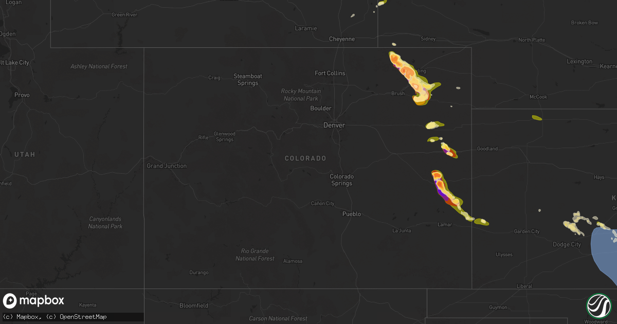
Hail Map in Colorado on May 23, 2025
Get this storm
May 23 map
$229
one time, instant access
Download today. No call, no setup
Keep the $229
Bought the map and want the full workflow? Apply the entire $229 to a subscription within 7 days. None of it is wasted.
Every map, not just this one
This buys you this map. Subscription and you get every map we run, in the markets you choose from a few cities to whole states to nationwide. Plus real-time alerts the moment a storm fires.
Contact data
Name, contact info, occupancy, even credit band for addresses in the footprint. You go from where it hit to who to call.
Become the source they trust
Unlimited branding weather history reports on demand. You already have the documented answer ready for the property owner, and you are the one who showed up with it.
Property data and RoofTrace estimates
Pull up any address you have got, its value and the exact code rules for that jurisdiction, straight from One Click Code. Then RoofTrace estimates the squares, pitch, and roof value, priced the way you price.
Storm reports in Colorado
Colorado
| Date | Description |
|---|---|
| 05/23/20256:55 PM CDT | Icechip report. Time estimated. |
| 05/23/20256:55 PM CDT | Report of damage to a home near the intersection of county road 47 and county road aa. No injuries reported. Time estimated. |
| 05/23/20256:52 PM CDT | Report of power lines down at county road aa and county road 40. Time estimated. |
| 05/23/20256:50 PM CDT | Icechip report. Time estimated. |
| 05/23/20256:30 PM CDT | Report from mping: hen egg |
| 05/23/20256:30 PM CDT | Report from mping: quarter |
| 05/23/20256:28 PM CDT | Cpw employee reported golf ball sized hail at prewitt reservoir. Relayed by county dispatch. |
| 05/23/20256:25 PM CDT | Report from mping: tennis ball |
| 05/23/20256:25 PM CDT | Trained spotter reported damage to two silos and a few trees near highway 6 and county road r. Time and location estimated. |
| 05/23/20256:23 PM CDT | Report from mping: hen egg |
| 05/23/20256:09 PM CDT | Report from mping: tea cup |
| 05/23/20256:09 PM CDT | Broadcast media and storm chaser footage of a tornado. Lasted approximately 5 minutes. Location estimated. |
| 05/23/20256:05 PM CDT | Report from mping: quarter |
| 05/23/20255:58 PM CDT | Report from mping: golf ball |
| 05/23/20255:57 PM CDT | Report from mping: hen egg |
| 05/23/20255:41 PM CDT | Report from mping: hen egg |
| 05/23/20255:35 PM CDT | Report from mping: golf ball |
| 05/23/20255:27 PM CDT | Report from mping: tennis ball |
| 05/23/20255:26 PM CDT | Report from mping: hen egg |
| 05/22/20259:51 PM CDT | A local report indicates 1.50 inch wind near Brandon |
| 05/22/20259:47 PM CDT | A local report indicates 1.25 inch wind near Brandon |
| 05/22/20258:49 PM CDT | Estimated 1.5-2 inch hail. |
| 05/22/20258:26 PM CDT | Report from mping: hen egg+ |
| 05/22/20258:24 PM CDT | Report from mping: baseball |
| 05/22/20258:20 PM CDT | Report from mping: golf ball |
| 05/22/20258:16 PM CDT | Picture of estimated golf ball to tennis ball size hail... Time estimated via radar. |
| 05/22/20258:02 PM CDT | A local report indicates 1.00 inch wind near 8 N Kit Carson |
| 05/22/20258:00 PM CDT | A local report indicates 1.75 inch wind near 8 N Kit Carson |
| 05/22/20257:26 PM CDT | Corrects previous hail report from stratton. Hail ranging from 1-1.5 inches occurring in stratton measured with tape measure. |
| 05/22/20257:26 PM CDT | Hail ranging from 1-1.5 inches occurring in stratton measured with tape measure. |
| 05/22/20257:24 PM CDT | Report of 2 inch hail in stratton with no rain or wind. |
| 05/22/20257:20 PM CDT | Report from mping: ping pong ball |
| 05/22/20257:11 PM CDT | Storm chaser video documented a brief tornado. Occurred in open fields with no visible damage noted. Location estimated. |
| 05/22/20257:08 PM CDT | Report from mping: hen egg+ |
| 05/22/20257:05 PM CDT | Report from mping: ping pong ball |
| 05/22/20257:04 PM CDT | Report from mping: quarter |
| 05/22/20257:03 PM CDT | Report from mping: golf ball |
All States Impacted by Hail Map on May 23, 2025
Cities Impacted by Hail Map on May 23, 2025
- Medford, OK
- Lamont, OK
- Tonkawa, OK
- West Palm Beach, FL
- Perry, OK
- Blackwell, OK
- Ponca City, OK
- Wellington, FL
- Lake Worth, FL
- Indiantown, FL
- Boynton Beach, FL
- Burbank, OK
- Loxahatchee, FL
- Palm Beach Gardens, FL
- Delray Beach, FL
- Carencro, LA
- Port Saint Lucie, FL
- Sunset, LA
- Okeechobee, FL
- Boca Raton, FL
- Deerfield Beach, FL
- Balmorhea, TX
- Fort Davis, TX
- Pompano Beach, FL
- Braithwaite, LA
- Coral Springs, FL
- Fort Lauderdale, FL
- Bartlesville, OK
- Pecos, TX
- Belle Rose, LA
- Cheyenne, WY
- Owasso, OK
- Sperry, OK
- Tulsa, OK
- Saint James, LA
- Lagrange, WY
- Albin, WY
- Fort Stockton, TX
- Pembroke Pines, FL
- Hollywood, FL
- Harrisburg, NE
- Ponchatoula, LA
- Hammond, LA
- Lyman, NE
- Pyote, TX
- Barstow, TX
- Kimball, NE
- Donaldsonville, LA
- Geismar, LA
- Baton Rouge, LA
- New Raymer, CO
- Loranger, LA
- Miami Gardens, FL
- Opa Locka, FL
- Lake Worth Beach, FL
- Gering, NE
- Scottsbluff, NE
- Stoneham, CO
- Merino, CO
- Sterling, CO
- Cope, CO
- Anton, CO
- Akron, CO
- Wink, TX
- Bogalusa, LA
- Franklinton, LA
- Minatare, NE
- Bayard, NE
- Marathon, TX
- Alliance, NE
- Labelle, FL
- Baker, LA
- Montgomery, TX
- Flagler, CO
- Seibert, CO
- Hockley, TX
- Magnolia, TX
- Hemingford, NE
- Angora, NE
- Atwood, CO
- Vona, CO
- Goldsmith, TX
- Big Cabin, OK
- Vinita, OK
- Afton, OK
- Ketchum, OK
- Jay, OK
- Eucha, OK
- Saint Francisville, LA
- Moore Haven, FL
- Brooklyn, MS
- New Augusta, MS
- Grove, OK
- Yuma, CO
- Lumberton, MS
- Columbia, MS
- Otis, CO
- Hay Springs, NE
- Clewiston, FL
- Stratton, CO
- Kit Carson, CO
- Ellsworth, NE
- Bethune, CO
- Tarzan, TX
- Burlington, CO
- Rushville, NE
- Gloster, MS
- Holyoke, CO
- Wray, CO
- Smithdale, MS
- Lenorah, TX
- Bogue Chitto, MS
- Crosby, MS
- Summit, MS
- Acme, LA
- Jonesville, LA
- Monterey, LA
- New Iberia, LA
- Jeanerette, LA
- Eckley, CO
- Gordon, NE
- Merriman, NE
- McCall Creek, MS
- Brookhaven, MS
- Natchez, MS
- Post, TX
- Fluvanna, TX
- Justiceburg, TX
- Guernsey, WY
- Wheatland, WY
- Yoder, WY
- Gail, TX
- Eads, CO
- Fort Laramie, WY
- Cheyenne Wells, CO
- Sheridan Lake, CO
- Lingle, WY
- Dryden, TX
- Veteran, WY
- Torrington, WY
- Billings, MO
- Morrill, NE
- Harrison, NE
- Mitchell, NE
- Holly, CO
- Syracuse, KS
- Jetmore, KS
- Ness City, KS
- Healy, KS
- Marshall, OK
- Mulhall, OK
- Orlando, OK
- Crescent, OK
- Hanston, KS
- Guthrie, OK
- Oklahoma City, OK
- Waukomis, OK
- Bison, OK
- Hennessey, OK
- Coyle, OK
- Perkins, OK
- Meridian, OK
- Wellston, OK
- Burdett, KS
- Fletcher, OK
- Stillwater, OK
- Luther, OK
- Tuttle, OK
- Amber, OK
- Elgin, OK
- Rush Springs, OK
- Claremore, OK
- Arcadia, OK
- Carney, OK
- Chandler, OK
- Chelsea, OK
- Pryor, OK
- Adair, OK
- Welch, OK
- Oberlin, KS
- Rozel, KS
- Larned, KS
- Morrison, OK
- Edmond, OK
- Cashion, OK
- Harrah, OK
- Jones, OK
- Glencoe, OK
- Meeker, OK
- Alex, OK
- Blanchard, OK
- Marlow, OK
- Delaware, OK
- Lenapah, OK
- Chapman, KS
- Gypsum, KS
- Pawnee, OK
- Assaria, KS
- Newcastle, OK
- Garfield, KS
- Hope, KS
- Woodbine, KS
- Yale, OK
- Washburn, MO
- Theodosia, MO
- Spearville, KS
- Norman, OK
- Mountain Home, AR
- Mustang, OK
- Mcpherson, KS
- Dewey, OK
- Offerle, KS
- Yukon, OK
- Piedmont, OK
- Omaha, AR
- Cedarcreek, MO
- Kirbyville, MO
- Hollister, MO
- El Reno, OK
- Cottonwood Falls, KS
- Emporia, KS
- Durham, KS
- Bluejacket, OK
- Washington, OK
- Mcloud, OK
- Fordland, MO
- Cassville, MO
- Miami, OK
- Minco, OK
- Midway, AR
- Nowata, OK
- Etowah, AR
- Caraway, AR
- Manila, AR
- Marked Tree, AR
- Osceola, AR
- Keiser, AR
- Lepanto, AR
- Bassett, AR
- Frenchmans Bayou, AR
- Joiner, AR
- Henning, TN
- Dyess, AR
- Tyronza, AR
- Wilson, AR
- Drummonds, TN
- Turrell, AR
- Lehigh, KS
- Belpre, KS
- Haviland, KS
- Protem, MO
- Lead Hill, AR
- Macksville, KS
- Purcell, OK
- Choctaw, OK
- Noble, OK
- Bethany, OK
- Peru, KS
- Covington, TN
- Millington, TN
- Brighton, TN
- Burlison, TN
- Munford, TN
- Pawhuska, OK
- Copan, OK
- Newalla, OK
- Douglass, KS
- Wichita, KS
- Okarche, OK
- Pontiac, MO
- Maize, KS
- Valley Center, KS
- Colwich, KS
- Andover, KS
- Rose Hill, KS
- Mount Hope, KS
- Kechi, KS
- Sedgwick, KS
- Lindsay, OK
- Byers, KS
- Pratt, KS
- Augusta, KS
- Moline, KS
- Cedar Vale, KS
- Hillsboro, KS
- Tampa, KS
- Peel, AR
- Spencer, OK
- Wann, OK
- Marquette, KS
- Bentley, KS
- Sylvia, KS
- Coats, KS
- Leon, KS
- Niotaze, KS
- Marion, KS
- Burrton, KS
- Greenwich, KS
- Benton, KS
- Sawyer, KS
- Sun City, KS
- Medicine Lodge, KS
- Grenola, KS
- Lindsborg, KS
- Rueter, MO
- Halstead, KS
- Turon, KS
- Towanda, KS
- Bartlett, KS
- Lehigh Acres, FL
- Hutchinson, KS
- Kinsley, KS
- Palm City, FL
- Atlanta, KS
- Sedan, KS
- El Dorado, KS
- Isabel, KS
- Chetopa, KS
- Baxter Springs, KS
- Columbus, KS
- Elk Falls, KS
- Lexington, OK
- Tecumseh, OK
- Agra, OK
- Howard, KS
- Newton, KS
- Macomb, OK
- Tryon, OK
- Wanette, OK
- Haven, KS
- Caney, KS
- Sharon, KS
- Picher, OK
- Quapaw, OK
- Ripley, OK
- Latham, KS
- Shawnee, OK
- Tyro, KS
- Independence, KS
- Coffeyville, KS
- Asher, OK
- Manville, WY
- Cushing, OK
- Pauls Valley, OK
- Stratford, OK
- Paoli, OK
- Longton, KS
- Cherokee, OK
- Mcalester, OK
- Dearing, KS
- Wakita, OK
- Burlington, OK
- Maud, OK
- Konawa, OK
- Helena, OK
- Stroud, OK
- Jennings, OK
- Pond Creek, OK
- Elk City, KS
- Depew, OK
- Paden, OK
- S Coffeyville, OK
- Riverton, KS
- Galena, KS
- Byars, OK
- Maramec, OK
- Beaumont, KS
- Piedmont, KS
- Udall, KS
- Goltry, OK
- Jet, OK
- Ada, OK
- Drumright, OK
- Nash, OK
- Winfield, KS
- Roff, OK
- Wynnewood, OK
- Rock, KS
- Castle, OK
- Bristow, OK
- Enid, OK
- Kremlin, OK
- Carrier, OK
- Hunter, OK
- Sasakwa, OK
- Fitzhugh, OK
- Allen, OK
- Tupelo, OK
- Stonewall, OK
- Dexter, KS
- Arkansas City, KS
- Maple City, KS
- Okemah, OK
- Billings, OK
- Mannford, OK
- Garber, OK
- Fittstown, OK
- Centrahoma, OK
- Lewis, KS
- Iuka, KS
- Greensburg, KS
- Wilmore, KS
- Coldwater, KS
- Mullinville, KS
- Zenda, KS
- Lake City, KS
- Nashville, KS
- Cunningham, KS
- Spivey, KS
- Attica, KS
- Harper, KS
- Anthony, KS
- Waldron, KS
- Hazelton, KS
- Alva, OK
- Kiowa, KS
- Hardtner, KS
- Kingman, KS
- Murdock, KS
- Cheney, KS
- Norwich, KS
- Stafford, KS
- St John, KS
- Plevna, KS
- Abbyville, KS
- Partridge, KS
- Arlington, KS
- Pretty Prairie, KS
- Garden Plain, KS
- Conway Springs, KS
- Viola, KS
- Derby, KS
- Mulvane, KS
- Haysville, KS
- Milton, KS
- Clearwater, KS
- Peck, KS
- Goddard, KS
- Argonia, KS
- Wellington, KS
- Belle Plaine, KS
- Caldwell, KS
- Freeport, KS
- Danville, KS
- Mayfield, KS
- Milan, KS
- Bluff City, KS
- Oxford, KS
- Amorita, OK
- South Haven, KS
- Manchester, OK
- Burden, KS
- Geuda Springs, KS
- Cambridge, KS
- Lucien, OK
- Braman, OK
- Dacoma, OK
- Shidler, OK
- Deer Creek, OK
- Douglas, OK
- Newkirk, OK
- Nardin, OK
- Marland, OK
- Fairmont, OK
- Red Rock, OK
- Covington, OK
- Carmen, OK
- Kaw City, OK
- Osage, OK
- Kellyville, OK
- Ozark, AR
- Prue, OK
- Hominy, OK
- Cleveland, OK
- Fairfax, OK
- Ralston, OK
- Glenrock, WY
- Garfield, AR
- Skiatook, OK
- Seligman, MO
- Havana, KS
- Chautauqua, KS
- Wynona, OK
- Barnsdall, OK
- Coalgate, OK
- Wapanucka, OK
- Atoka, OK
- Douglas, WY
- Ramona, OK
- Ochelata, OK
- Terlton, OK
- Sand Springs, OK
- Tishomingo, OK
- Talala, OK
- Collinsville, OK
- Oologah, OK
- Vera, OK
- Lamar, OK
- Davenport, OK
- Broken Arrow, OK
- Inola, OK
- Wagoner, OK
- Coweta, OK
- Dustin, OK
- Bushnell, NE
- Shawnee, WY
- Saint Joe, AR
- Wetumka, OK
- Hanna, OK
- Lost Springs, WY
- Andale, KS
- Prague, OK
- Indianola, OK
- Sparks, OK
- Boley, OK
- Okmulgee, OK
- Eufaula, OK
- Porter, OK
- Chouteau, OK
- Morris, OK
- Jenks, OK
- Redbird, OK
- Braggs, OK
- Glenpool, OK
- Bixby, OK
- Muskogee, OK
- Hulbert, OK
- Boynton, OK
- Council Hill, OK
- Mounds, OK
- Catoosa, OK
- Kiefer, OK
- Haskell, OK
- Fort Gibson, OK
- Locust Grove, OK
- Sapulpa, OK
- Taft, OK
- Beggs, OK
- Oktaha, OK
- Checotah, OK
- Warner, OK
- Weleetka, OK
- Henryetta, OK
- Stigler, OK
- Webbers Falls, OK
- Porum, OK
- Fairland, OK


