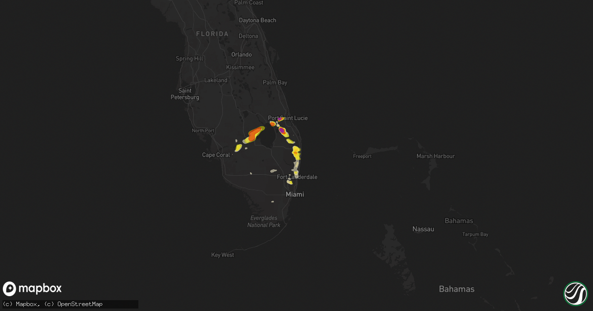
Hail Map on May 23, 2025
Get this storm
May 23 map
$229
one time, instant access
Download today. No call, no setup
Keep the $229
Bought the map and want the full workflow? Apply the entire $229 to a subscription within 7 days. None of it is wasted.
Every map, not just this one
This buys you this map. Subscription and you get every map we run, in the markets you choose from a few cities to whole states to nationwide. Plus real-time alerts the moment a storm fires.
Contact data
Name, contact info, occupancy, even credit band for addresses in the footprint. You go from where it hit to who to call.
Become the source they trust
Unlimited branding weather history reports on demand. You already have the documented answer ready for the property owner, and you are the one who showed up with it.
Property data and RoofTrace estimates
Pull up any address you have got, its value and the exact code rules for that jurisdiction, straight from One Click Code. Then RoofTrace estimates the squares, pitch, and roof value, priced the way you price.
States Impacted by Hail Map on May 23, 2025
Storm reports
Kansas
| Date | Description |
|---|---|
| 05/23/20255:22 AM CDT | A local report indicates 60 MPH wind near Caney |
| 05/23/20253:55 AM CDT | A local report indicates 63 MPH wind near Wellington Airport |
| 05/23/20252:43 AM CDT | Ambient weather network station: kzlf transmitter site. |
| 05/23/202512:55 AM CDT | Mping report. Time adjusted based on radar. |
| 05/22/20259:32 PM CDT | Heavy rain and 1 inch hail reported 6 miles west of oberlin. |
| 05/22/20259:32 PM CDT | Corrects previous hail report from 6 w oberlin. Heavy rain and 1 inch hail reported 6 miles west of oberlin. |
Texas
| Date | Description |
|---|---|
| 05/23/20255:15 PM CDT | Mesonet station fw9693 pyote. |
| 05/23/20254:55 PM CDT | Mesonet station twb24 5.3 ne hovey |
Arkansas
| Date | Description |
|---|---|
| 05/23/20251:42 AM CDT | Reported multiple large trees down in wilson... Ar. Time and location estimated on radar. |
Oklahoma
| Date | Description |
|---|---|
| 05/23/20256:44 AM CDT | Kmko measurement. |
| 05/23/20256:25 AM CDT | Power lines down. |
| 05/23/20256:20 AM CDT | A local report indicates 60 MPH wind near 1 WNW Hectorville |
| 05/23/20256:20 AM CDT | A local report indicates 65 MPH wind near 4 W Hectorville |
| 05/23/20256:20 AM CDT | (t |
| 05/23/20256:16 AM CDT | (t |
| 05/23/20256:16 AM CDT | A local report indicates 63 MPH wind near Chouteau |
| 05/23/20256:15 AM CDT | Roof off mobile home. |
| 05/23/20256:05 AM CDT | A local report indicates 60 MPH wind near 2 NE Bixby |
| 05/23/20256:05 AM CDT | Large branches down on aspen between 81st and 91st. |
| 05/23/20256:00 AM CDT | Tree limb down 75th & mingo. |
| 05/23/20255:54 AM CDT | Several large trees down. A few power lines down. |
| 05/23/20255:51 AM CDT | Large tree down blocking roadway. |
| 05/23/20255:51 AM CDT | Several large tree limbs down. |
| 05/23/20255:50 AM CDT | A local report indicates 58 MPH wind near 3 NNW Stillwater |
| 05/23/20255:45 AM CDT | A local report indicates 63 MPH wind near 4 NW Talala |
| 05/23/20255:45 AM CDT | Numerous large tree limbs down in the neighborhood. Also reported 5 to 6 minutes of hail up to dime size. Time estimated via radar. |
| 05/23/20255:45 AM CDT | Large tree down. Fences damaged. Several large limbs down. |
| 05/23/20255:38 AM CDT | Metal roof blown off munical building downtown. Several large trees down. |
| 05/23/20255:35 AM CDT | A local report indicates 64 MPH wind near Cushing |
| 05/23/20255:30 AM CDT | Numerous large trees and tree branches down across hominy. Citywide power outage as of 5:30am. |
| 05/23/20255:27 AM CDT | Numerous trees down. Roof off outbuildings. Several power lines down. |
| 05/23/20255:25 AM CDT | A local report indicates 65 MPH wind near 2 S Wynona |
| 05/23/20255:21 AM CDT | A local report indicates 73 MPH wind near 7 S Wynona |
| 05/23/20255:20 AM CDT | A local report indicates 61 MPH wind near 2 S Wynona |
| 05/23/20255:18 AM CDT | Asos station kswo stillwater. |
| 05/23/20255:10 AM CDT | A local report indicates 64 MPH wind near 3 ENE Pawnee |
| 05/23/20255:05 AM CDT | A local report indicates 58 MPH wind near 8 ESE Foraker |
| 05/23/20255:00 AM CDT | A local report indicates 61 MPH wind near 7 SW Burbank |
| 05/23/20254:58 AM CDT | Also nickel size hail. |
| 05/23/20254:55 AM CDT | A local report indicates 63 MPH wind near 7 S Red Rock |
| 05/23/20254:45 AM CDT | A local report indicates 61 MPH wind near 8 SW Hardy |
| 05/23/20254:45 AM CDT | Mesonet station newk newkirk. |
| 05/23/20254:45 AM CDT | A local report indicates 61 MPH wind near Newkirk |
| 05/23/20254:39 AM CDT | Report from mping: half dollar |
| 05/23/20254:26 AM CDT | Trained spotter measured a wind gust of 77 mph as the storm moved through ada. |
| 05/23/20254:21 AM CDT | A local report indicates 77 MPH wind near 1 W Ada |
| 05/23/20254:15 AM CDT | A local report indicates 2.00 inch wind near 4 NE Vanoss |
| 05/23/20254:12 AM CDT | Report from mping: quarter |
| 05/23/20254:00 AM CDT | Several trees down. Time estimated by radar. |
| 05/23/20253:44 AM CDT | Trees blown down over the road. |
| 05/23/20253:20 AM CDT | Report from mping: half dollar |
| 05/23/20253:15 AM CDT | Golf ball sized hail reported south of sh9 at 192nd avenue se. |
| 05/23/20253:02 AM CDT | A local report indicates 1.25 inch wind near 3 S Stillwater |
| 05/23/20252:45 AM CDT | Via social media: large tree limbs broken. |
| 05/23/20252:34 AM CDT | A local report indicates 1.00 inch wind near 2 N Norman |
| 05/23/20252:22 AM CDT | Report from mping: quarter |
| 05/23/20252:22 AM CDT | Report from mping: quarter |
| 05/23/20252:10 AM CDT | Report from mping: quarter |
| 05/23/20252:09 AM CDT | Report from mping: quarter |
| 05/23/20251:51 AM CDT | Report from mping: quarter |
| 05/23/20251:15 AM CDT | Social media picture of hailstones. |
| 05/23/20251:06 AM CDT | A local report indicates 1.25 inch wind near 4 W Norman |
| 05/23/202512:16 AM CDT | A local report indicates 1.00 inch wind near 3 NW Carney |
| 05/23/202512:16 AM CDT | A local report indicates 1.25 inch wind near 4 N Stillwater |
Nebraska
| Date | Description |
|---|---|
| 05/23/20256:53 PM CDT | Facebook report with photo of quarter to half dollar sized hail. |
| 05/23/20256:37 PM CDT | A local report indicates 1.75 inch wind near Hemingford |
| 05/23/20256:30 PM CDT | Facebook post and video of ping pong ball sized hail. |
| 05/23/20255:48 PM CDT | Facebook image of 1.25in hail northeast of lake minatare. |
| 05/23/20255:31 PM CDT | Mping report of 1 inch hail just northeast of scottsbluff. |
| 05/23/20255:26 PM CDT | Quarter sized hail reported by media via slack. |
| 05/22/20257:29 PM CDT | A local report indicates 1.75 inch wind near 14 S Hay Springs |
| 05/22/20257:12 PM CDT | A local report indicates 1.00 inch wind near 21 SSE Hay Springs |
Wyoming
| Date | Description |
|---|---|
| 05/22/202510:24 PM CDT | A local report indicates 1.00 inch wind near 6 WNW Lyman |
| 05/22/20259:45 PM CDT | A local report indicates 1.75 inch wind near 3 N Veteran |
| 05/22/20259:31 PM CDT | A local report indicates 1.75 inch wind near 11 WSW Lingle |
Colorado
| Date | Description |
|---|---|
| 05/23/20256:55 PM CDT | Icechip report. Time estimated. |
| 05/23/20256:55 PM CDT | Report of damage to a home near the intersection of county road 47 and county road aa. No injuries reported. Time estimated. |
| 05/23/20256:52 PM CDT | Report of power lines down at county road aa and county road 40. Time estimated. |
| 05/23/20256:50 PM CDT | Icechip report. Time estimated. |
| 05/23/20256:30 PM CDT | Report from mping: quarter |
| 05/23/20256:30 PM CDT | Report from mping: hen egg |
| 05/23/20256:28 PM CDT | Cpw employee reported golf ball sized hail at prewitt reservoir. Relayed by county dispatch. |
| 05/23/20256:25 PM CDT | Trained spotter reported damage to two silos and a few trees near highway 6 and county road r. Time and location estimated. |
| 05/23/20256:25 PM CDT | Report from mping: tennis ball |
| 05/23/20256:23 PM CDT | Report from mping: hen egg |
| 05/23/20256:09 PM CDT | Report from mping: tea cup |
| 05/23/20256:09 PM CDT | Broadcast media and storm chaser footage of a tornado. Lasted approximately 5 minutes. Location estimated. |
| 05/23/20256:05 PM CDT | Report from mping: quarter |
| 05/23/20255:58 PM CDT | Report from mping: golf ball |
| 05/23/20255:57 PM CDT | Report from mping: hen egg |
| 05/23/20255:41 PM CDT | Report from mping: hen egg |
| 05/23/20255:35 PM CDT | Report from mping: golf ball |
| 05/23/20255:27 PM CDT | Report from mping: tennis ball |
| 05/23/20255:26 PM CDT | Report from mping: hen egg |
| 05/22/20259:51 PM CDT | A local report indicates 1.50 inch wind near Brandon |
| 05/22/20259:47 PM CDT | A local report indicates 1.25 inch wind near Brandon |
| 05/22/20258:49 PM CDT | Estimated 1.5-2 inch hail. |
| 05/22/20258:26 PM CDT | Report from mping: hen egg+ |
| 05/22/20258:24 PM CDT | Report from mping: baseball |
| 05/22/20258:20 PM CDT | Report from mping: golf ball |
| 05/22/20258:16 PM CDT | Picture of estimated golf ball to tennis ball size hail... Time estimated via radar. |
| 05/22/20258:02 PM CDT | A local report indicates 1.00 inch wind near 8 N Kit Carson |
| 05/22/20258:00 PM CDT | A local report indicates 1.75 inch wind near 8 N Kit Carson |
| 05/22/20257:26 PM CDT | Hail ranging from 1-1.5 inches occurring in stratton measured with tape measure. |
| 05/22/20257:26 PM CDT | Corrects previous hail report from stratton. Hail ranging from 1-1.5 inches occurring in stratton measured with tape measure. |
| 05/22/20257:24 PM CDT | Report of 2 inch hail in stratton with no rain or wind. |
| 05/22/20257:20 PM CDT | Report from mping: ping pong ball |
| 05/22/20257:11 PM CDT | Storm chaser video documented a brief tornado. Occurred in open fields with no visible damage noted. Location estimated. |
| 05/22/20257:08 PM CDT | Report from mping: hen egg+ |
| 05/22/20257:05 PM CDT | Report from mping: ping pong ball |
| 05/22/20257:04 PM CDT | Report from mping: quarter |
| 05/22/20257:03 PM CDT | Report from mping: golf ball |
Florida
| Date | Description |
|---|---|
| 05/23/20256:14 PM CDT | Broadcast media shared photos of half dollar size hail that occurred over la belle as a severe thunderstorm moved overhead. |
| 05/23/20254:50 PM CDT | Miramar police are on the scene in the 2700 block of sunshine boulevard due to downed power lines and storm related damage due to a severe thunderstorm downburst. Sunsh |
| 05/23/20254:44 PM CDT | Preliminary report from the fll/hwo emergency manager stating that a cessna was lifted up and onto a fuel truck during a severe thunderstorm downburst. Time estimation |
| 05/23/20254:44 PM CDT | Fll/hwo emergency manager provided a second update that multiple aircraft at north perry airport were damaged beyond repair. No injuries were reported. |
| 05/23/20254:38 PM CDT | Off duty nws employee reports several large tree branches down near the intersection of nw 99th ave and johnson street as a severe thunderstorm downburst occurred. Time |
| 05/23/20254:38 PM CDT | Off duty nws employee reported quarter size hail in pembroke pines. |
| 05/23/20254:35 PM CDT | Member of the public reported half dollar size hail in pembroke pines. |
| 05/23/20254:30 PM CDT | Broadcast media shared photos of a large tree uprooted by severe downburst winds... Time estimated by kamx radar returns. |
| 05/23/20252:30 PM CDT | Social media photo of a large tree down on the road in the high point community of delray beach. Time estimated via kamx reflectivity. |
| 05/23/20252:18 PM CDT | Trained spotter in indiantown reports hail up to 2 inches in diameter. |
| 05/23/20252:18 PM CDT | Member of the public reported ping pong ball size hail in western lake worth. |
| 05/23/20252:09 PM CDT | Trained spotter reported quarter size hail in lake worth near the turnpike and southern boulevard. |
| 05/23/20252:00 PM CDT | Trained weather spotter reported quarter size hail in lake worth. |
| 05/22/20257:21 PM CDT | Social media image depicts a flipped and damaged mobile home trailer associated with a strong thunderstorm downburst. |
Cities Impacted by Hail Map on May 23, 2025
- Medford, OK
- Lamont, OK
- Tonkawa, OK
- West Palm Beach, FL
- Perry, OK
- Blackwell, OK
- Ponca City, OK
- Wellington, FL
- Lake Worth, FL
- Indiantown, FL
- Boynton Beach, FL
- Burbank, OK
- Loxahatchee, FL
- Palm Beach Gardens, FL
- Delray Beach, FL
- Carencro, LA
- Port Saint Lucie, FL
- Sunset, LA
- Okeechobee, FL
- Boca Raton, FL
- Deerfield Beach, FL
- Balmorhea, TX
- Fort Davis, TX
- Pompano Beach, FL
- Braithwaite, LA
- Coral Springs, FL
- Fort Lauderdale, FL
- Bartlesville, OK
- Pecos, TX
- Belle Rose, LA
- Cheyenne, WY
- Owasso, OK
- Sperry, OK
- Tulsa, OK
- Saint James, LA
- Lagrange, WY
- Albin, WY
- Fort Stockton, TX
- Pembroke Pines, FL
- Hollywood, FL
- Harrisburg, NE
- Ponchatoula, LA
- Hammond, LA
- Lyman, NE
- Pyote, TX
- Barstow, TX
- Kimball, NE
- Donaldsonville, LA
- Geismar, LA
- Baton Rouge, LA
- New Raymer, CO
- Loranger, LA
- Miami Gardens, FL
- Opa Locka, FL
- Lake Worth Beach, FL
- Gering, NE
- Scottsbluff, NE
- Stoneham, CO
- Merino, CO
- Sterling, CO
- Cope, CO
- Anton, CO
- Akron, CO
- Wink, TX
- Bogalusa, LA
- Franklinton, LA
- Minatare, NE
- Bayard, NE
- Marathon, TX
- Alliance, NE
- Labelle, FL
- Baker, LA
- Montgomery, TX
- Flagler, CO
- Seibert, CO
- Hockley, TX
- Magnolia, TX
- Hemingford, NE
- Angora, NE
- Atwood, CO
- Vona, CO
- Goldsmith, TX
- Big Cabin, OK
- Vinita, OK
- Afton, OK
- Ketchum, OK
- Jay, OK
- Eucha, OK
- Saint Francisville, LA
- Moore Haven, FL
- Brooklyn, MS
- New Augusta, MS
- Grove, OK
- Yuma, CO
- Lumberton, MS
- Columbia, MS
- Otis, CO
- Hay Springs, NE
- Clewiston, FL
- Stratton, CO
- Kit Carson, CO
- Ellsworth, NE
- Bethune, CO
- Tarzan, TX
- Burlington, CO
- Rushville, NE
- Gloster, MS
- Holyoke, CO
- Wray, CO
- Smithdale, MS
- Lenorah, TX
- Bogue Chitto, MS
- Crosby, MS
- Summit, MS
- Acme, LA
- Jonesville, LA
- Monterey, LA
- New Iberia, LA
- Jeanerette, LA
- Eckley, CO
- Gordon, NE
- Merriman, NE
- McCall Creek, MS
- Brookhaven, MS
- Natchez, MS
- Post, TX
- Fluvanna, TX
- Justiceburg, TX
- Guernsey, WY
- Wheatland, WY
- Yoder, WY
- Gail, TX
- Eads, CO
- Fort Laramie, WY
- Cheyenne Wells, CO
- Sheridan Lake, CO
- Lingle, WY
- Dryden, TX
- Veteran, WY
- Torrington, WY
- Billings, MO
- Morrill, NE
- Harrison, NE
- Mitchell, NE
- Holly, CO
- Syracuse, KS
- Jetmore, KS
- Ness City, KS
- Healy, KS
- Marshall, OK
- Mulhall, OK
- Orlando, OK
- Crescent, OK
- Hanston, KS
- Guthrie, OK
- Oklahoma City, OK
- Waukomis, OK
- Bison, OK
- Hennessey, OK
- Coyle, OK
- Perkins, OK
- Meridian, OK
- Wellston, OK
- Burdett, KS
- Fletcher, OK
- Stillwater, OK
- Luther, OK
- Tuttle, OK
- Amber, OK
- Elgin, OK
- Rush Springs, OK
- Claremore, OK
- Arcadia, OK
- Carney, OK
- Chandler, OK
- Chelsea, OK
- Pryor, OK
- Adair, OK
- Welch, OK
- Oberlin, KS
- Rozel, KS
- Larned, KS
- Morrison, OK
- Edmond, OK
- Cashion, OK
- Harrah, OK
- Jones, OK
- Glencoe, OK
- Meeker, OK
- Alex, OK
- Blanchard, OK
- Marlow, OK
- Delaware, OK
- Lenapah, OK
- Chapman, KS
- Gypsum, KS
- Pawnee, OK
- Assaria, KS
- Newcastle, OK
- Garfield, KS
- Hope, KS
- Woodbine, KS
- Yale, OK
- Washburn, MO
- Theodosia, MO
- Spearville, KS
- Norman, OK
- Mountain Home, AR
- Mustang, OK
- Mcpherson, KS
- Dewey, OK
- Offerle, KS
- Yukon, OK
- Piedmont, OK
- Omaha, AR
- Cedarcreek, MO
- Kirbyville, MO
- Hollister, MO
- El Reno, OK
- Cottonwood Falls, KS
- Emporia, KS
- Durham, KS
- Bluejacket, OK
- Washington, OK
- Mcloud, OK
- Fordland, MO
- Cassville, MO
- Miami, OK
- Minco, OK
- Midway, AR
- Nowata, OK
- Etowah, AR
- Caraway, AR
- Manila, AR
- Marked Tree, AR
- Osceola, AR
- Keiser, AR
- Lepanto, AR
- Bassett, AR
- Frenchmans Bayou, AR
- Joiner, AR
- Henning, TN
- Dyess, AR
- Tyronza, AR
- Wilson, AR
- Drummonds, TN
- Turrell, AR
- Lehigh, KS
- Belpre, KS
- Haviland, KS
- Protem, MO
- Lead Hill, AR
- Macksville, KS
- Purcell, OK
- Choctaw, OK
- Noble, OK
- Bethany, OK
- Peru, KS
- Covington, TN
- Millington, TN
- Brighton, TN
- Burlison, TN
- Munford, TN
- Pawhuska, OK
- Copan, OK
- Newalla, OK
- Douglass, KS
- Wichita, KS
- Okarche, OK
- Pontiac, MO
- Maize, KS
- Valley Center, KS
- Colwich, KS
- Andover, KS
- Rose Hill, KS
- Mount Hope, KS
- Kechi, KS
- Sedgwick, KS
- Lindsay, OK
- Byers, KS
- Pratt, KS
- Augusta, KS
- Moline, KS
- Cedar Vale, KS
- Hillsboro, KS
- Tampa, KS
- Peel, AR
- Spencer, OK
- Wann, OK
- Marquette, KS
- Bentley, KS
- Sylvia, KS
- Coats, KS
- Leon, KS
- Niotaze, KS
- Marion, KS
- Burrton, KS
- Greenwich, KS
- Benton, KS
- Sawyer, KS
- Sun City, KS
- Medicine Lodge, KS
- Grenola, KS
- Lindsborg, KS
- Rueter, MO
- Halstead, KS
- Turon, KS
- Towanda, KS
- Bartlett, KS
- Lehigh Acres, FL
- Hutchinson, KS
- Kinsley, KS
- Palm City, FL
- Atlanta, KS
- Sedan, KS
- El Dorado, KS
- Isabel, KS
- Chetopa, KS
- Baxter Springs, KS
- Columbus, KS
- Elk Falls, KS
- Lexington, OK
- Tecumseh, OK
- Agra, OK
- Howard, KS
- Newton, KS
- Macomb, OK
- Tryon, OK
- Wanette, OK
- Haven, KS
- Caney, KS
- Sharon, KS
- Picher, OK
- Quapaw, OK
- Ripley, OK
- Latham, KS
- Shawnee, OK
- Tyro, KS
- Independence, KS
- Coffeyville, KS
- Asher, OK
- Manville, WY
- Cushing, OK
- Pauls Valley, OK
- Stratford, OK
- Paoli, OK
- Longton, KS
- Cherokee, OK
- Mcalester, OK
- Dearing, KS
- Wakita, OK
- Burlington, OK
- Maud, OK
- Konawa, OK
- Helena, OK
- Stroud, OK
- Jennings, OK
- Pond Creek, OK
- Elk City, KS
- Depew, OK
- Paden, OK
- S Coffeyville, OK
- Riverton, KS
- Galena, KS
- Byars, OK
- Maramec, OK
- Beaumont, KS
- Piedmont, KS
- Udall, KS
- Goltry, OK
- Jet, OK
- Ada, OK
- Drumright, OK
- Nash, OK
- Winfield, KS
- Roff, OK
- Wynnewood, OK
- Rock, KS
- Castle, OK
- Bristow, OK
- Enid, OK
- Kremlin, OK
- Carrier, OK
- Hunter, OK
- Sasakwa, OK
- Fitzhugh, OK
- Allen, OK
- Tupelo, OK
- Stonewall, OK
- Dexter, KS
- Arkansas City, KS
- Maple City, KS
- Okemah, OK
- Billings, OK
- Mannford, OK
- Garber, OK
- Fittstown, OK
- Centrahoma, OK
- Lewis, KS
- Iuka, KS
- Greensburg, KS
- Wilmore, KS
- Coldwater, KS
- Mullinville, KS
- Zenda, KS
- Lake City, KS
- Nashville, KS
- Cunningham, KS
- Spivey, KS
- Attica, KS
- Harper, KS
- Anthony, KS
- Waldron, KS
- Hazelton, KS
- Alva, OK
- Kiowa, KS
- Hardtner, KS
- Kingman, KS
- Murdock, KS
- Cheney, KS
- Norwich, KS
- Stafford, KS
- St John, KS
- Plevna, KS
- Abbyville, KS
- Partridge, KS
- Arlington, KS
- Pretty Prairie, KS
- Garden Plain, KS
- Conway Springs, KS
- Viola, KS
- Derby, KS
- Mulvane, KS
- Haysville, KS
- Milton, KS
- Clearwater, KS
- Peck, KS
- Goddard, KS
- Argonia, KS
- Wellington, KS
- Belle Plaine, KS
- Caldwell, KS
- Freeport, KS
- Danville, KS
- Mayfield, KS
- Milan, KS
- Bluff City, KS
- Oxford, KS
- Amorita, OK
- South Haven, KS
- Manchester, OK
- Burden, KS
- Geuda Springs, KS
- Cambridge, KS
- Lucien, OK
- Braman, OK
- Dacoma, OK
- Shidler, OK
- Deer Creek, OK
- Douglas, OK
- Newkirk, OK
- Nardin, OK
- Marland, OK
- Fairmont, OK
- Red Rock, OK
- Covington, OK
- Carmen, OK
- Kaw City, OK
- Osage, OK
- Kellyville, OK
- Ozark, AR
- Prue, OK
- Hominy, OK
- Cleveland, OK
- Fairfax, OK
- Ralston, OK
- Glenrock, WY
- Garfield, AR
- Skiatook, OK
- Seligman, MO
- Havana, KS
- Chautauqua, KS
- Wynona, OK
- Barnsdall, OK
- Coalgate, OK
- Wapanucka, OK
- Atoka, OK
- Douglas, WY
- Ramona, OK
- Ochelata, OK
- Terlton, OK
- Sand Springs, OK
- Tishomingo, OK
- Talala, OK
- Collinsville, OK
- Oologah, OK
- Vera, OK
- Lamar, OK
- Davenport, OK
- Broken Arrow, OK
- Inola, OK
- Wagoner, OK
- Coweta, OK
- Dustin, OK
- Bushnell, NE
- Shawnee, WY
- Saint Joe, AR
- Wetumka, OK
- Hanna, OK
- Lost Springs, WY
- Andale, KS
- Prague, OK
- Indianola, OK
- Sparks, OK
- Boley, OK
- Okmulgee, OK
- Eufaula, OK
- Porter, OK
- Chouteau, OK
- Morris, OK
- Jenks, OK
- Redbird, OK
- Braggs, OK
- Glenpool, OK
- Bixby, OK
- Muskogee, OK
- Hulbert, OK
- Boynton, OK
- Council Hill, OK
- Mounds, OK
- Catoosa, OK
- Kiefer, OK
- Haskell, OK
- Fort Gibson, OK
- Locust Grove, OK
- Sapulpa, OK
- Taft, OK
- Beggs, OK
- Oktaha, OK
- Checotah, OK
- Warner, OK
- Weleetka, OK
- Henryetta, OK
- Stigler, OK
- Webbers Falls, OK
- Porum, OK
- Fairland, OK