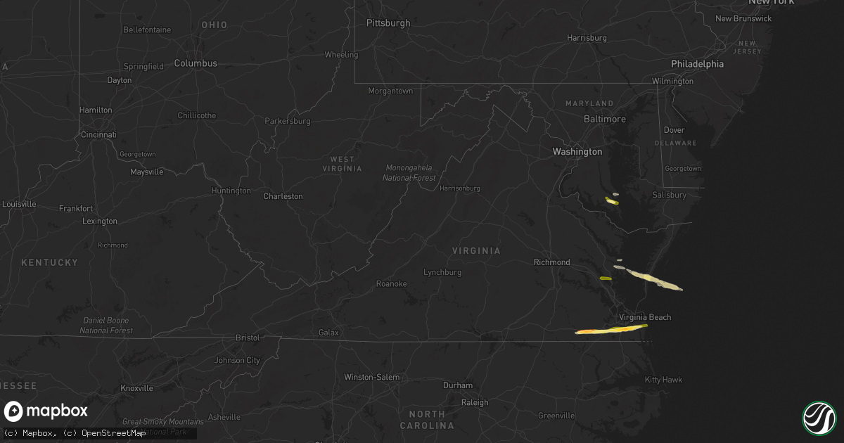
Hail Map in Virginia on May 22, 2025
Get this storm
May 22 map
$229
one time, instant access
Download today. No call, no setup
Keep the $229
Bought the map and want the full workflow? Apply the entire $229 to a subscription within 7 days. None of it is wasted.
Every map, not just this one
This buys you this map. Subscription and you get every map we run, in the markets you choose from a few cities to whole states to nationwide. Plus real-time alerts the moment a storm fires.
Contact data
Name, contact info, occupancy, even credit band for addresses in the footprint. You go from where it hit to who to call.
Become the source they trust
Unlimited branding weather history reports on demand. You already have the documented answer ready for the property owner, and you are the one who showed up with it.
Property data and RoofTrace estimates
Pull up any address you have got, its value and the exact code rules for that jurisdiction, straight from One Click Code. Then RoofTrace estimates the squares, pitch, and roof value, priced the way you price.
Storm reports in Virginia
Virginia
| Date | Description |
|---|---|
| 05/22/20256:51 PM CDT | Estimated quarter sized hail reported near courtland. Time estimated from radar. |
| 05/22/20256:45 PM CDT | Public reported quarter sized hail and crop damage just north of cape charles on facebook. Time estimated based on radar. |
| 05/22/20256:10 PM CDT | Public reported nickel to quarter sized hail near deltaville in middlesex county via twitter/x. Time estimated from radar. |
| 05/22/20255:35 PM CDT | Public reported estimated quarter sized hail near rosewell area in gloucester county via twitter/x. Time estimated from radar. |
| 05/22/20255:31 PM CDT | A local report indicates 1.00 inch wind near 2 SSE Clay Bank |
| 05/21/20258:00 PM CDT | Estimated egg size hail near the grassfield high school in chesapeake. Time estimated from radar. |
| 05/21/20257:55 PM CDT | A local report indicates 1.00 inch wind near 1 W Great Bridge |
| 05/21/20257:53 PM CDT | A local report indicates 1.00 inch wind near 1 SE Herberts Corner |
| 05/21/20257:00 PM CDT | Golf ball size hail reported at the serve restaurant in downtown franklin. Others reported minor damage to their car nearby. |
All States Impacted by Hail Map on May 22, 2025
Cities Impacted by Hail Map on May 22, 2025
- Joplin, MO
- Duenweg, MO
- Lawton, OK
- Duncan, OK
- Comanche, OK
- Marlow, OK
- Chickasha, OK
- Amber, OK
- Blanchard, OK
- Foster, OK
- Elmore City, OK
- Pocasset, OK
- Lindsay, OK
- Maysville, OK
- Pauls Valley, OK
- Wynnewood, OK
- Ringling, OK
- Bristow, OK
- Okemah, OK
- Castle, OK
- Depew, OK
- Waurika, OK
- Alex, OK
- Loco, OK
- Washington, OK
- Paoli, OK
- Healdton, OK
- Okmulgee, OK
- Noble, OK
- Ratliff City, OK
- Tussy, OK
- Wilson, OK
- Purcell, OK
- Henryetta, OK
- Hennepin, OK
- Wayne, OK
- Springer, OK
- Graham, OK
- Lexington, OK
- Mulhall, OK
- Ardmore, OK
- Coyle, OK
- Davis, OK
- Stillwater, OK
- Lone Grove, OK
- Marietta, OK
- Overbrook, OK
- Burneyville, OK
- Norman, OK
- Tecumseh, OK
- Wanette, OK
- Perkins, OK
- Fairmont, OK
- Covington, OK
- Lucien, OK
- Perry, OK
- Chandler, OK
- Wellston, OK
- Sparks, OK
- Davenport, OK
- Tryon, OK
- Carney, OK
- Agra, OK
- Gainesville, TX
- Muenster, TX
- Thackerville, OK
- Whitesboro, TX
- Valley View, TX
- Tioga, TX
- Collinsville, TX
- Pilot Point, TX
- Lindsay, TX
- Sanger, TX
- Lake Placid, FL
- Venus, FL
- Madill, OK
- Arcadia, FL
- Okeechobee, FL
- Lockport, LA
- Bourg, LA
- Holliday, TX
- Seymour, TX
- Fort Stockton, TX
- Montegut, LA
- Zolfo Springs, FL
- Mill Creek, OK
- Electra, TX
- Iowa Park, TX
- Olney, TX
- Spur, TX
- Crosbyton, TX
- Ralls, TX
- Matador, TX
- Labelle, FL
- Burkburnett, TX
- Floydada, TX
- Wichita Falls, TX
- Grandfield, OK
- Devol, OK
- Randlett, OK
- Windthorst, TX
- Vernon, TX
- Post, TX
- Justiceburg, TX
- Paducah, TX
- Snyder, TX
- Newcastle, TX
- Loving, TX
- Graham, TX
- Temple, OK
- Walters, OK
- Cee Vee, TX
- Iraan, TX
- Clewiston, FL
- Dryden, TX
- Childress, TX
- Junction, TX
- Byers, TX
- Clinton, AR
- Shirley, AR
- Petrolia, TX
- Ryan, OK
- Bryson, TX
- Fairfield Bay, AR
- Higden, AR
- Mason, TX
- Crowell, TX
- Hollywood, MD
- Leonardtown, MD
- Dripping Springs, TX
- Hermleigh, TX
- Heber Springs, AR
- Marathon, TX
- Quanah, TX
- Midkiff, TX
- Llano, TX
- Great Mills, MD
- Lexington Park, MD
- California, MD
- Graford, TX
- Patuxent River, MD
- Chillicothe, TX
- Dutton, VA
- North, VA
- Searcy, AR
- Pangburn, AR
- Lusby, MD
- Mountain Home, TX
- Big Lake, TX
- Eldorado, OK
- Goree, TX
- Munday, TX
- Miami, FL
- Moon, VA
- Hudgins, VA
- Mathews, VA
- Cobbs Creek, VA
- Round Mountain, TX
- Diggs, VA
- Throckmorton, TX
- Rule, TX
- Buchanan Dam, TX
- Kingsland, TX
- Burnet, TX
- Garden City, TX
- Big Spring, TX
- Cape Charles, VA
- San Marcos, TX
- Machipongo, VA
- Kingsbury, TX
- Martindale, TX
- Oklaunion, TX
- Franklin, VA
- Suffolk, VA
- Harrold, TX
- Maxwell, TX
- Harper, TX
- Carrsville, VA
- Courtland, VA
- Palo Pinto, TX
- Ingram, TX
- Kyle, TX
- Valley Spring, TX
- Seguin, TX
- Deltaville, VA
- Fredericksburg, TX
- Willow City, TX
- Davidson, OK
- Chesapeake, VA
- Lockhart, TX
- Lampasas, TX
- New Braunfels, TX
- Newsoms, VA
- Strawn, TX
- South Bend, TX
- Gordon, TX
- Breckenridge, TX
- Lipan, TX
- Santo, TX
- Buda, TX
- Dale, TX
- Austin, TX
- Del Valle, TX
- Burns, WY
- Johnson City, TX
- Virginia Beach, VA
- Carpenter, WY
- Woodson, TX
- Stonewall, TX
- Pine Bluffs, WY
- Hye, TX
- Albany, TX
- Bushnell, NE
- Grover, CO
- Driftwood, TX
- Boerne, TX
- Blanco, TX
- Caddo, TX
- Cisco, TX
- Moran, TX
- Eastland, TX
- Miles, TX
- Wheatland, WY
- Ranger, TX
- Gorman, TX
- Desdemona, TX
- De Leon, TX
- Carbon, TX
- Rising Star, TX
- Comanche, TX
- Paint Rock, TX
- Mereta, TX
- San Angelo, TX
- Comfort, TX
- New Raymer, CO
- May, TX
- Cross Plains, TX
- Brownwood, TX
- Burkett, TX
- Ballinger, TX
- Coleman, TX
- Talpa, TX
- Novice, TX
- Clyde, TX
- Baird, TX
- Valera, TX
- Rowena, TX
- Santa Anna, TX
- Eola, TX
- Voss, TX
- Eden, TX
- Millersview, TX
- Vancourt, TX
- Gouldbusk, TX
- Melvin, TX
- Bangs, TX
- Lohn, TX
- Doole, TX
- Rockwood, TX
- Rochelle, TX
- Brookesmith, TX
- Early, TX
- Sidney, TX
- Yoder, WY
- Lingle, WY
- Kimball, NE
- Stoneham, CO
- Padroni, CO
- Kerrville, TX
- Torrington, WY
- Veteran, WY
- Richland Springs, TX
- Cheyenne, WY
- Brady, TX
- Center Point, TX
- Blanket, TX
- Sterling, CO
- Mullin, TX
- Lyman, NE
- Zephyr, TX
- Albin, WY
- Atwood, CO
- Gering, NE
- Mitchell, NE
- Morrill, NE
- San Saba, TX
- Harrisburg, NE
- Hawk Springs, WY
- Fleming, CO
- Medina, TX
- Goldthwaite, TX
- Lometa, TX
- Cherokee, TX
- Tow, TX
- Art, TX
- Voca, TX
- Castell, TX
- Fredonia, TX
- Pontotoc, TX
- Hext, TX
- Menard, TX
- London, TX
- Otis, CO
- Yuma, CO
- Haxtun, CO
- Avon, NC
- Bluffton, TX
- Sidney, NE
- Rocksprings, TX
- Lodgepole, NE
- Sonora, TX
- Horseshoe Bay, TX
- Bayard, NE
- Eldorado, TX
- Chappell, NE
- Dalton, NE
- Potter, NE
- Leakey, TX
- Gurley, NE
- Kendalia, TX
- Anson, TX
- Sylvester, TX
- Roby, TX
- McCaulley, TX
- Rio Frio, TX
- Williamsburg, VA
- Hayes, VA
- Gloucester, VA
- Concan, TX
- Shawnee, OK
- Merkel, TX
- Barksdale, TX
- Utopia, TX
- Hawley, TX
- Sabinal, TX
- Trent, TX
- Sweetwater, TX
- Knippa, TX
- Wake, VA
- Hardyville, VA


