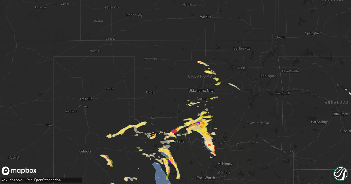
Hail Map in Oklahoma on May 22, 2025
Get this storm
May 22 map
$229
one time, instant access
Download today. No call, no setup
Keep the $229
Bought the map and want the full workflow? Apply the entire $229 to a subscription within 7 days. None of it is wasted.
Every map, not just this one
This buys you this map. Subscription and you get every map we run, in the markets you choose from a few cities to whole states to nationwide. Plus real-time alerts the moment a storm fires.
Contact data
Name, contact info, occupancy, even credit band for addresses in the footprint. You go from where it hit to who to call.
Become the source they trust
Unlimited branding weather history reports on demand. You already have the documented answer ready for the property owner, and you are the one who showed up with it.
Property data and RoofTrace estimates
Pull up any address you have got, its value and the exact code rules for that jurisdiction, straight from One Click Code. Then RoofTrace estimates the squares, pitch, and roof value, priced the way you price.
Storm reports in Oklahoma
Oklahoma
| Date | Description |
|---|---|
| 05/22/20255:28 PM CDT | A local report indicates 1.25 inch wind near 3 SE Velma |
| 05/22/20255:15 PM CDT | A local report indicates 1.25 inch wind near 5 E Walters |
| 05/22/20255:14 PM CDT | A local report indicates 1.50 inch wind near 7 W Velma |
| 05/22/20255:13 PM CDT | A local report indicates 1.00 inch wind near 5 E Walters |
| 05/22/20255:04 PM CDT | Time estimated from radar. Report from x. |
| 05/22/20254:46 PM CDT | A local report indicates 1.50 inch wind near Cookietown |
| 05/22/20254:35 PM CDT | A local report indicates 2.00 inch wind near 2 NW Randlett |
| 05/22/20254:27 PM CDT | Time estimated from radar. |
| 05/22/20254:24 PM CDT | A local report indicates 1.75 inch wind near 3 NW Devol |
| 05/22/20254:20 PM CDT | Time estimated from radar. Report in nwschat. |
| 05/22/202512:53 PM CDT | Report from mping: golf ball |
| 05/22/202512:44 PM CDT | Wind driven hail. Time estimated from radar. |
| 05/22/202512:38 PM CDT | Outbuilding was overturned and tossed into trees north of thackerville on the east side of 35 near hutchins rd. Time based on radar. |
| 05/22/202512:30 PM CDT | A local report indicates 65 MPH wind near 2 SE Burneyville |
| 05/22/202512:25 PM CDT | A local report indicates 62 MPH wind near 2 SE Thackerville |
| 05/22/202511:34 AM CDT | A local report indicates 1.00 inch wind near 3 S Chandler |
| 05/22/202511:23 AM CDT | A local report indicates 1.00 inch wind near 1 N Covington |
| 05/22/202511:23 AM CDT | Report from mping: half dollar |
| 05/22/202511:20 AM CDT | A local report indicates 1.75 inch wind near Covington |
| 05/22/202511:17 AM CDT | Report from mping: quarter |
| 05/22/202511:13 AM CDT | Report from mping: quarter |
| 05/22/202511:00 AM CDT | A local report indicates 1.00 inch wind near Perkins |
| 05/22/202510:55 AM CDT | A local report indicates 2.00 inch wind near 1 SSE Tatums |
| 05/22/202510:45 AM CDT | A local report indicates 1.00 inch wind near 4 SSW Pink |
| 05/22/202510:38 AM CDT | Time based on radar. |
| 05/22/202510:32 AM CDT | A local report indicates 1.50 inch wind near Wilson |
| 05/22/202510:10 AM CDT | A local report indicates 1.00 inch wind near 1 S Healdton |
| 05/22/202510:10 AM CDT | Report from mping: quarter |
| 05/22/20258:46 AM CDT | Report from mping: ping pong ball |
| 05/22/20258:36 AM CDT | Report from mping: quarter |
All States Impacted by Hail Map on May 22, 2025
Cities Impacted by Hail Map on May 22, 2025
- Joplin, MO
- Duenweg, MO
- Lawton, OK
- Duncan, OK
- Comanche, OK
- Marlow, OK
- Chickasha, OK
- Amber, OK
- Blanchard, OK
- Foster, OK
- Elmore City, OK
- Pocasset, OK
- Lindsay, OK
- Maysville, OK
- Pauls Valley, OK
- Wynnewood, OK
- Ringling, OK
- Bristow, OK
- Okemah, OK
- Castle, OK
- Depew, OK
- Waurika, OK
- Alex, OK
- Loco, OK
- Washington, OK
- Paoli, OK
- Healdton, OK
- Okmulgee, OK
- Noble, OK
- Ratliff City, OK
- Tussy, OK
- Wilson, OK
- Purcell, OK
- Henryetta, OK
- Hennepin, OK
- Wayne, OK
- Springer, OK
- Graham, OK
- Lexington, OK
- Mulhall, OK
- Ardmore, OK
- Coyle, OK
- Davis, OK
- Stillwater, OK
- Lone Grove, OK
- Marietta, OK
- Overbrook, OK
- Burneyville, OK
- Norman, OK
- Tecumseh, OK
- Wanette, OK
- Perkins, OK
- Fairmont, OK
- Covington, OK
- Lucien, OK
- Perry, OK
- Chandler, OK
- Wellston, OK
- Sparks, OK
- Davenport, OK
- Tryon, OK
- Carney, OK
- Agra, OK
- Gainesville, TX
- Muenster, TX
- Thackerville, OK
- Whitesboro, TX
- Valley View, TX
- Tioga, TX
- Collinsville, TX
- Pilot Point, TX
- Lindsay, TX
- Sanger, TX
- Lake Placid, FL
- Venus, FL
- Madill, OK
- Arcadia, FL
- Okeechobee, FL
- Lockport, LA
- Bourg, LA
- Holliday, TX
- Seymour, TX
- Fort Stockton, TX
- Montegut, LA
- Zolfo Springs, FL
- Mill Creek, OK
- Electra, TX
- Iowa Park, TX
- Olney, TX
- Spur, TX
- Crosbyton, TX
- Ralls, TX
- Matador, TX
- Labelle, FL
- Burkburnett, TX
- Floydada, TX
- Wichita Falls, TX
- Grandfield, OK
- Devol, OK
- Randlett, OK
- Windthorst, TX
- Vernon, TX
- Post, TX
- Justiceburg, TX
- Paducah, TX
- Snyder, TX
- Newcastle, TX
- Loving, TX
- Graham, TX
- Temple, OK
- Walters, OK
- Cee Vee, TX
- Iraan, TX
- Clewiston, FL
- Dryden, TX
- Childress, TX
- Junction, TX
- Byers, TX
- Clinton, AR
- Shirley, AR
- Petrolia, TX
- Ryan, OK
- Bryson, TX
- Fairfield Bay, AR
- Higden, AR
- Mason, TX
- Crowell, TX
- Hollywood, MD
- Leonardtown, MD
- Dripping Springs, TX
- Hermleigh, TX
- Heber Springs, AR
- Marathon, TX
- Quanah, TX
- Midkiff, TX
- Llano, TX
- Great Mills, MD
- Lexington Park, MD
- California, MD
- Graford, TX
- Patuxent River, MD
- Chillicothe, TX
- Dutton, VA
- North, VA
- Searcy, AR
- Pangburn, AR
- Lusby, MD
- Mountain Home, TX
- Big Lake, TX
- Eldorado, OK
- Goree, TX
- Munday, TX
- Miami, FL
- Moon, VA
- Hudgins, VA
- Mathews, VA
- Cobbs Creek, VA
- Round Mountain, TX
- Diggs, VA
- Throckmorton, TX
- Rule, TX
- Buchanan Dam, TX
- Kingsland, TX
- Burnet, TX
- Garden City, TX
- Big Spring, TX
- Cape Charles, VA
- San Marcos, TX
- Machipongo, VA
- Kingsbury, TX
- Martindale, TX
- Oklaunion, TX
- Franklin, VA
- Suffolk, VA
- Harrold, TX
- Maxwell, TX
- Harper, TX
- Carrsville, VA
- Courtland, VA
- Palo Pinto, TX
- Ingram, TX
- Kyle, TX
- Valley Spring, TX
- Seguin, TX
- Deltaville, VA
- Fredericksburg, TX
- Willow City, TX
- Davidson, OK
- Chesapeake, VA
- Lockhart, TX
- Lampasas, TX
- New Braunfels, TX
- Newsoms, VA
- Strawn, TX
- South Bend, TX
- Gordon, TX
- Breckenridge, TX
- Lipan, TX
- Santo, TX
- Buda, TX
- Dale, TX
- Austin, TX
- Del Valle, TX
- Burns, WY
- Johnson City, TX
- Virginia Beach, VA
- Carpenter, WY
- Woodson, TX
- Stonewall, TX
- Pine Bluffs, WY
- Hye, TX
- Albany, TX
- Bushnell, NE
- Grover, CO
- Driftwood, TX
- Boerne, TX
- Blanco, TX
- Caddo, TX
- Cisco, TX
- Moran, TX
- Eastland, TX
- Miles, TX
- Wheatland, WY
- Ranger, TX
- Gorman, TX
- Desdemona, TX
- De Leon, TX
- Carbon, TX
- Rising Star, TX
- Comanche, TX
- Paint Rock, TX
- Mereta, TX
- San Angelo, TX
- Comfort, TX
- New Raymer, CO
- May, TX
- Cross Plains, TX
- Brownwood, TX
- Burkett, TX
- Ballinger, TX
- Coleman, TX
- Talpa, TX
- Novice, TX
- Clyde, TX
- Baird, TX
- Valera, TX
- Rowena, TX
- Santa Anna, TX
- Eola, TX
- Voss, TX
- Eden, TX
- Millersview, TX
- Vancourt, TX
- Gouldbusk, TX
- Melvin, TX
- Bangs, TX
- Lohn, TX
- Doole, TX
- Rockwood, TX
- Rochelle, TX
- Brookesmith, TX
- Early, TX
- Sidney, TX
- Yoder, WY
- Lingle, WY
- Kimball, NE
- Stoneham, CO
- Padroni, CO
- Kerrville, TX
- Torrington, WY
- Veteran, WY
- Richland Springs, TX
- Cheyenne, WY
- Brady, TX
- Center Point, TX
- Blanket, TX
- Sterling, CO
- Mullin, TX
- Lyman, NE
- Zephyr, TX
- Albin, WY
- Atwood, CO
- Gering, NE
- Mitchell, NE
- Morrill, NE
- San Saba, TX
- Harrisburg, NE
- Hawk Springs, WY
- Fleming, CO
- Medina, TX
- Goldthwaite, TX
- Lometa, TX
- Cherokee, TX
- Tow, TX
- Art, TX
- Voca, TX
- Castell, TX
- Fredonia, TX
- Pontotoc, TX
- Hext, TX
- Menard, TX
- London, TX
- Otis, CO
- Yuma, CO
- Haxtun, CO
- Avon, NC
- Bluffton, TX
- Sidney, NE
- Rocksprings, TX
- Lodgepole, NE
- Sonora, TX
- Horseshoe Bay, TX
- Bayard, NE
- Eldorado, TX
- Chappell, NE
- Dalton, NE
- Potter, NE
- Leakey, TX
- Gurley, NE
- Kendalia, TX
- Anson, TX
- Sylvester, TX
- Roby, TX
- McCaulley, TX
- Rio Frio, TX
- Williamsburg, VA
- Hayes, VA
- Gloucester, VA
- Concan, TX
- Shawnee, OK
- Merkel, TX
- Barksdale, TX
- Utopia, TX
- Hawley, TX
- Sabinal, TX
- Trent, TX
- Sweetwater, TX
- Knippa, TX
- Wake, VA
- Hardyville, VA


