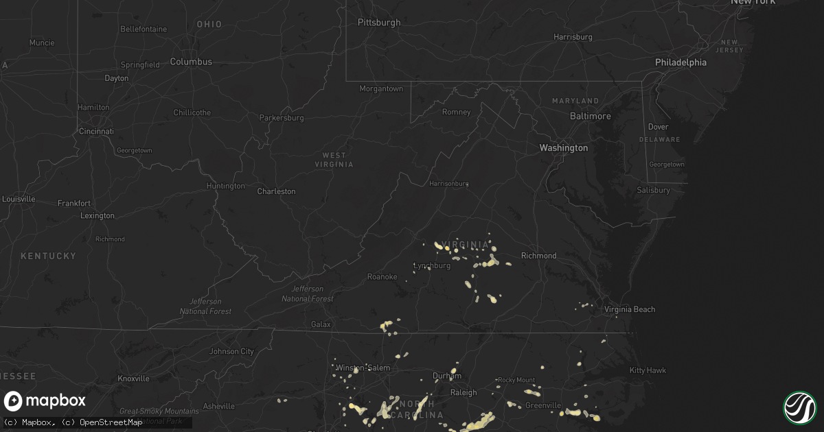
Hail Map in Virginia on May 22, 2012
Get this storm
May 22 map
$229
one time, instant access
Download today. No call, no setup
Keep the $229
Bought the map and want the full workflow? Apply the entire $229 to a subscription within 7 days. None of it is wasted.
Every map, not just this one
This buys you this map. Subscription and you get every map we run, in the markets you choose from a few cities to whole states to nationwide. Plus real-time alerts the moment a storm fires.
Contact data
Name, contact info, occupancy, even credit band for addresses in the footprint. You go from where it hit to who to call.
Become the source they trust
Unlimited branding weather history reports on demand. You already have the documented answer ready for the property owner, and you are the one who showed up with it.
Property data and RoofTrace estimates
Pull up any address you have got, its value and the exact code rules for that jurisdiction, straight from One Click Code. Then RoofTrace estimates the squares, pitch, and roof value, priced the way you price.
Storm reports in Virginia
Virginia
| Date | Description |
|---|---|
| 05/22/20125:12 PM CDT | Quarter sized hail fell on highway 221 on west side of lynchburg city |
| 05/22/20125:00 PM CDT | Hail lasted several minutes |
| 05/22/20125:00 PM CDT | Hail lasted for 5 to 10 minutes. |
| 05/22/20124:55 PM CDT | Hail lasted for 5 to 10 minutes. |
| 05/22/20124:30 PM CDT | Lowesville road |
| 05/21/20127:49 PM CDT | Large tree limb came down and tore into screened in porch...time based on radar estimate |
| 05/21/20127:42 PM CDT | Nickel to quarter size hail |
| 05/21/20127:35 PM CDT | A local report indicates 1.00 inch wind near CUMBERLAND |
| 05/21/20127:05 PM CDT | A local report indicates 1.00 inch wind near GRASSY CREEK |
| 05/21/20127:03 PM CDT | A local report indicates 1.25 inch wind near 1 WNW CHESTNUT KNOB |
All States Impacted by Hail Map on May 22, 2012
Cities Impacted by Hail Map on May 22, 2012
- Balmorhea, TX
- Gregory, SD
- Edgeley, ND
- Kulm, ND
- Ewing, NE
- Chambers, NE
- Inman, NE
- Forest, VA
- Morgan, GA
- Leary, GA
- Quincy, FL
- Chattahoochee, FL
- Hosford, FL
- Arrington, VA
- Amherst, VA
- Salisbury, NC
- Rockwell, NC
- Hamlet, NC
- Winston Salem, NC
- Clemmons, NC
- Lansford, ND
- Macclesfield, NC
- Pinetops, NC
- Hannaford, ND
- Benson, NC
- Four Oaks, NC
- Jamestown, SC
- Georgetown, SC
- Scotland Neck, NC
- Salemburg, NC
- Roseboro, NC
- Clinton, NC
- Simpsonville, SC
- Fountain Inn, SC
- Gray Court, SC
- Eureka, SD
- Blair, SC
- Whitmire, SC
- Carlisle, SC
- Moncks Corner, SC
- Marathon, TX
- Albany, GA
- Rocky Point, NC
- Hampstead, NC
- Chocowinity, NC
- Dublin, GA
- Bainbridge, GA
- Pelham, GA
- Camilla, GA
- Whigham, GA
- Climax, GA
- Milton, ND
- Currie, NC
- Wilmington, NC
- Burgaw, NC
- Mocksville, NC
- Cameron, LA
- Creole, LA
- Jacksonville, NC
- Ocklawaha, FL
- Bristol, FL
- Ridgeville, SC
- Summerville, SC
- Alpena, SD
- Fortuna, ND
- Keysville, VA
- Cullen, VA
- Charlotte Court House, VA
- Enderlin, ND
- Sheldon, ND
- Lisbon, ND
- Waycross, GA
- Lehr, ND
- Fredonia, ND
- Dawsonville, GA
- Cumming, GA
- Gladstone, VA
- Omega, GA
- Riegelwood, NC
- Council, NC
- Oriska, ND
- Tower City, ND
- Westby, MT
- Wishek, ND
- Bladenboro, NC
- Evergreen, NC
- Fort Pierce, FL
- Hosmer, SD
- Jeanerette, LA
- Columbus, ND
- Moultrie, GA
- Baconton, GA
- Lenox, GA
- Enigma, GA
- Sumner, GA
- Sylvester, GA
- Alapaha, GA
- Willacoochee, GA
- Ty Ty, GA
- Norman Park, GA
- Tifton, GA
- Doerun, GA
- Wilson, NC
- Stantonsburg, NC
- Gold Hill, NC
- Gackle, ND
- Ray City, GA
- Lakeland, GA
- Valdosta, GA
- Scranton, NC
- Belhaven, NC
- Millwood, GA
- Fingal, ND
- Lillington, NC
- Java, SD
- Roscoe, SD
- Nahunta, GA
- Walterboro, SC
- Round O, SC
- Pinopolis, SC
- Franklin, LA
- Woonsocket, SD
- Streeter, ND
- Jamestown, ND
- Jud, ND
- Cleveland, ND
- Chester, SC
- Fargo, GA
- Homerville, GA
- Windsor, VA
- Martinsville, VA
- White River, SD
- Folkston, GA
- White Oak, GA
- Kingsland, GA
- Wade, NC
- Stedman, NC
- Godwin, NC
- Autryville, NC
- Brunswick, GA
- Waverly, GA
- Nakina, NC
- Whiteville, NC
- Dillwyn, VA
- Arvonia, VA
- Montpelier, ND
- Ypsilanti, ND
- Spiritwood, ND
- Marion, ND
- Donnybrook, ND
- Berthold, ND
- Stanley, ND
- Huron, SD
- Hartsfield, GA
- Ridgeway, VA
- Spencer, VA
- Middleburg, FL
- Green Cove Springs, FL
- Mohall, ND
- Carpio, ND
- Souris, ND
- Westhope, ND
- Holly Ridge, NC
- Saint Stephen, SC
- Cross, SC
- Pineville, SC
- Argyle, MN
- Hawthorne, FL
- Franklinville, NC
- Asheboro, NC
- Ramseur, NC
- Sanborn, ND
- Chadbourn, NC
- Clarksville, FL
- Tallahassee, FL
- Crawfordville, FL
- Altha, FL
- Blountstown, FL
- Telogia, FL
- Sopchoppy, FL
- Fountain, FL
- Bolton, NC
- Farmville, VA
- Pamplin, VA
- Du Pont, GA
- Chinquapin, NC
- Fedora, SD
- Artesian, SD
- Pittsboro, NC
- Loris, SC
- Sea Island, GA
- Saint Simons Island, GA
- Arlington, GA
- Creedmoor, NC
- Durham, NC
- Grand Chenier, LA
- Patterson, GA
- Summerton, SC
- Manning, SC
- Matthews, NC
- Bath, NC
- Pinetown, NC
- Washington, NC
- Wyndmere, ND
- Selma, NC
- Smithfield, NC
- Dunn, NC
- Newton Grove, NC
- Princeton, NC
- Pine Level, NC
- Longs, SC
- Tabor City, NC
- Clarendon, NC
- Conway, SC
- Eden, NC
- Anderson, SC
- Clarkton, NC
- Amelia Court House, VA
- Bonneau, SC
- Buchanan, ND
- Axton, VA
- Bailey, NC
- Spring Hope, NC
- Andrews, SC
- Smithfield, VA
- Huger, SC
- Lake Waccamaw, NC
- Arlington, SD
- Brooklet, GA
- Fayetteville, NC
- Reidsville, GA
- Kenmare, ND
- Raeford, NC
- Waynesville, GA
- Colerain, NC
- Binford, ND
- Aneta, ND
- Rockingham, NC
- White Lake, SD
- Laurinburg, NC
- Wagram, NC
- Nashville, GA
- Lynchburg, VA
- Colquitt, GA
- Morganton, NC
- Cumberland, VA
- Powhatan, VA
- Tarboro, NC
- Green Sea, SC
- Yemassee, SC
- Green Pond, SC
- Piedmont, SC
- Pelzer, SC
- Ambrose, ND
- Jefferson, SC
- Kershaw, SC
- Greeleyville, SC
- Damascus, GA
- Newton, GA
- Miller, SD
- Kings Bay, GA
- Saint Marys, GA
- Yulee, FL
- Latta, SC
- Marion, SC
- Grimesland, NC
- Greenville, NC
- Orrum, NC
- Mcville, ND
- Jessie, ND
- Cooperstown, ND
- Rogers, ND
- Valley City, ND
- Wallace, SC
- Charleston, SC
- Winnie, TX
- Anahuac, TX
- Kenbridge, VA
- Victoria, VA
- Rockham, SD
- Lumberton, NC
- Cerro Gordo, NC
- Buckingham, VA
- Coats, NC
- Aynor, SC
- Lawtey, FL
- Starke, FL
- Plentywood, MT
- Bowdle, SD
- Selby, SD
- Powers Lake, ND
- Stockton, GA
- Edinburg, ND
- Hoople, ND
- Hahira, GA
- Red Springs, NC
- Wessington, SD
- Wessington Springs, SD
- Star, NC
- Chamberlain, SD
- Harrellsville, NC
- Fort Mill, SC
- Lancaster, SC
- Williston, FL
- Morriston, FL
- Troy, NC
- Crosby, ND
- Carthage, NC
- Goldston, NC
- Bear Creek, NC
- Siler City, NC
- Sanford, NC
- Robbins, NC
- South Mills, NC
- Graham, NC
- Langford, SD
- Amherst, SD
- Bunnell, FL
- Palm Coast, FL
- Cartersville, VA
- Albemarle, NC
- New London, NC
- Wood, SD
- Broadway, NC
- Jesup, GA
- Ludowici, GA
- Saint Pauls, NC
- Barney, ND
- Reidsville, NC
- Browns Summit, NC
- Sale City, GA
- Heath Springs, SC
- Hallsboro, NC
- Westport, SD
- Aberdeen, SD
- Bennettsville, SC
- Zuni, VA
- Parkton, NC
- Noonan, ND
- Bronson, FL
- Lexington, NC
- Hilliard, FL
- Marianna, FL
- Cottondale, FL
- Alford, FL
- Merry Hill, NC
- Sutton, ND
- Willow Lake, SD
- Iroquois, SD
- Jekyll Island, GA
- Courtenay, ND
- Wimbledon, ND
- Edison, GA
- Spencer, NC
- Monroe, VA
- Maxbass, ND
- Rose Hill, NC
- Teachey, NC
- Dazey, ND
- Capitol, MT
- Buffalo, SD
- Alzada, MT
- China Grove, NC
- Manor, GA
- Argyle, GA
- Antler, ND
- Hitchcock, SD
- Wolsey, SD
- Chipley, FL
- Adel, GA
- Newberry, SC
- Union, SC
- Bowbells, ND
- Blackstone, VA
- Yadkinville, NC
- Boonville, NC
- Verona, ND
- Frederick, SD
- Cordesville, SC
- Seabrook, SC
- Beaufort, SC
- Adams Run, SC
- Cottageville, SC
- Norris, SD
- Statesboro, GA
- Lewisville, NC
- Fort Stewart, GA
- Black Creek, NC
- Fremont, NC
- Hope Mills, NC
- Concord, NC
- Parmelee, SD
- Hoboken, GA
- Gann Valley, SD
- Page, ND
- Kannapolis, NC
- Dickey, ND
- Ivanhoe, NC
- Willard, NC
- Ruffin, SC
- Harmony, NC
- Advance, NC
- Erwin, NC
- Bunnlevel, NC
- Linden, NC
- Oakes, ND
- Ashley, ND
- Chapel Hill, NC
- Carrboro, NC
- Fork Union, VA
- Palmyra, VA
- Bell City, LA
- Shannon, NC
- Richlands, NC
- Beulaville, NC
- Leland, NC
- Seagrove, NC
- Darlington, SC
- Greenville, SC
- Appomattox, VA
- Hoffman, NC
- Pinebluff, NC
- Aberdeen, NC
- Columbia, VA
- Bremo Bluff, VA
- Fulton, SD
- Stephen, MN
- Gibsonville, NC
- Walstonburg, NC
- New Iberia, LA
- Darien, GA
- Hamill, SD
- Fort McCoy, FL
- Astor, FL
- Dauphin Island, AL
- Osnabrock, ND
- Mitchell, SD
- Oacoma, SD
- Harleyville, SC
- Dorchester, SC
- Gaffney, SC
- Sharon, ND
- Estill, SC
- Britton, SD
- Gibson, NC
- Laurel Hill, NC
- Claxton, GA
- Vero Beach, FL
- Cascade, VA
- Carpenter, SD
- Draper, SD
- Ivor, VA
- Litchville, ND
- Hammond, MT
- Boyes, MT
- Fairdale, ND
- Palermo, ND
- Chesapeake, VA
- Manvel, ND
- Oslo, MN
- Alvarado, MN
- Goode, VA
- Baxley, GA
- Richfield, NC
- Orlando, FL
- Eutawville, SC
- Holly Hill, SC
- Pantego, NC
- Lancaster, MN
- Nicholls, GA
- Douglas, GA
- Connelly Springs, NC
- Hickory, NC
- Drakes Branch, VA
- Roper, NC
- Plymouth, NC
- Lidgerwood, ND
- Savannah, GA
- Elizabeth City, NC
- Gwinner, ND
- Mount Gilead, NC
- Blackshear, GA
- Mershon, GA
- Cayuga, ND
- Plankinton, SD
- Prospect, VA
- Lyons, GA
- Glennville, GA
- Yale, SD
- De Smet, SD
- Kimball, SD
- Pukwana, SD
- Uvalda, GA
- Surrency, GA
- Bedford, VA
- McGrath, MN
- Dillon, SC
- Marston, NC
- Menlo, GA
- Rising Fawn, GA
- Lignite, ND
- Middlesex, NC
- Shipman, VA
- Schuyler, VA
- Meherrin, VA
- Sellers, SC
- Northwood, ND
- Saint Bernard, LA
- Crescent City, FL
- Elkton, VA
- Mauldin, SC
- Jacksonville, FL
- Hemingway, SC
- Kathryn, ND
- Wadesboro, NC
- Bristol, GA
- Screven, GA
- Abbeville, LA
- Alexandria, SD
- Leola, SD
- Mooreton, ND
- Denton, NC
- Tolley, ND
- Morven, NC
- Redfield, SD
- Ashton, SD
- Winner, SD
- Fort Ransom, ND
- Bluffton, GA
- Pearson, GA
- Maple Hill, NC
- Castle Hayne, NC
- Raiford, FL
- Wahpeton, ND
- Duncan, SC
- Greer, SC
- Hope, ND
- Pillsbury, ND


