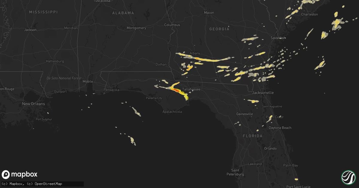
Hail Map on May 22, 2012
Get this storm
May 22 map
$229
one time, instant access
Download today. No call, no setup
Keep the $229
Bought the map and want the full workflow? Apply the entire $229 to a subscription within 7 days. None of it is wasted.
Every map, not just this one
This buys you this map. Subscription and you get every map we run, in the markets you choose from a few cities to whole states to nationwide. Plus real-time alerts the moment a storm fires.
Contact data
Name, contact info, occupancy, even credit band for addresses in the footprint. You go from where it hit to who to call.
Become the source they trust
Unlimited branding weather history reports on demand. You already have the documented answer ready for the property owner, and you are the one who showed up with it.
Property data and RoofTrace estimates
Pull up any address you have got, its value and the exact code rules for that jurisdiction, straight from One Click Code. Then RoofTrace estimates the squares, pitch, and roof value, priced the way you price.
States Impacted by Hail Map on May 22, 2012
Storm reports
South Dakota
| Date | Description |
|---|---|
| 05/22/20126:45 PM CDT | A local report indicates 1.00 inch wind near 3 SE SELBY |
| 05/21/201211:20 PM CDT | Mostly nickel sized hail but a few to quarter sized. |
| 05/21/201211:20 PM CDT | 2 to 3 inch branches down in the yard |
| 05/21/201211:07 PM CDT | Hail report relayed through hand county emergency manager |
| 05/21/20129:11 PM CDT | Measured at andover rwis site |
| 05/21/20128:10 PM CDT | A local report indicates 60 MPH wind near 3 WNW LEOLA |
| 05/21/20127:58 PM CDT | Spotternetwork.org report |
| 05/21/20127:48 PM CDT | Spotternetwork.org report |
| 05/21/20127:30 PM CDT | A local report indicates 1.00 inch wind near HOSMER |
| 05/21/20127:15 PM CDT | A local report indicates 60 MPH wind near 10 NNE WHITE RIVER |
| 05/21/20127:14 PM CDT | A local report indicates 61 MPH wind near BUFFALO |
| 05/21/20127:13 PM CDT | A local report indicates 1.75 inch wind near 6 W EUREKA |
| 05/21/20127:10 PM CDT | Storm chaser reported golf ball hail |
North Dakota
| Date | Description |
|---|---|
| 05/22/20126:35 PM CDT | A local report indicates 1.00 inch wind near 7 N TAGUS |
| 05/22/20126:24 PM CDT | A local report indicates 1.00 inch wind near 7 N TAGUS |
| 05/22/20124:55 PM CDT | 4 to 6 inch diameter branches broken off |
| 05/21/201211:15 PM CDT | Several quarters mixed with some smaller hail. |
| 05/21/201210:47 PM CDT | Wind gust measured to 50 kt on observation |
| 05/21/201210:45 PM CDT | Couple trees down in town. Time estimated. |
| 05/21/201210:30 PM CDT | Turtle river state park. Ash and oak trees up to 22 inch diameter snapped. Time approximate. |
| 05/21/20129:55 PM CDT | A local report indicates 1.00 inch wind near 6 NE BINFORD |
| 05/21/20129:10 PM CDT | Some branches on the ground |
| 05/21/20129:07 PM CDT | Relayed from em... Hail occurring during call |
| 05/21/20129:07 PM CDT | Relayed from em... Hail occurring during call |
| 05/21/20129:00 PM CDT | Quarter sized hail damaged car. Spotter reported seeing wall cloud 20 minutes prior near same location. |
| 05/21/20129:00 PM CDT | Estimated 60 mph winds and reported no damage. |
| 05/21/20128:55 PM CDT | Golf ball sized hail reported |
| 05/21/20128:34 PM CDT | Hail almost covering the ground |
| 05/21/20128:29 PM CDT | A local report indicates 1.25 inch wind near 5 N GACKLE |
| 05/21/20128:27 PM CDT | Hail lasted around 7 minutes |
| 05/21/20128:13 PM CDT | Small amount of 1 inch hail |
| 05/21/20128:00 PM CDT | Hail damaged vehicles and ongoing at time of call |
| 05/21/20127:50 PM CDT | A local report indicates 1.00 inch wind near 6 SE LANSFORD |
| 05/21/20127:50 PM CDT | A local report indicates 1.00 inch wind near 4 SE LANSFORD |
Louisiana
| Date | Description |
|---|---|
| 05/22/20125:15 PM CDT | Wind damage reported to a house in creole. |
| 05/22/20125:10 PM CDT | Wind damage reported to a barn near creole. |
| 05/22/20125:01 PM CDT | Nickel to quarter size hail reported by sheriffs deputy on highway 27 north of creole. |
| 05/22/20124:58 PM CDT | Nickel to quarter size hail reported near grand chenier |
Georgia
| Date | Description |
|---|---|
| 05/22/20126:30 PM CDT | A tree was reported down on highway 82 in willacoochee. Time of event estimated by radar. |
| 05/22/20126:10 PM CDT | Trees down around alapaha. |
| 05/22/20125:40 PM CDT | Estimated quarter size hail at the eldorado food market just east of i-75. |
| 05/22/20125:38 PM CDT | Quarter sized hail east of omega ended near time listed. |
| 05/22/20125:28 PM CDT | Deputy estimated 70 mph winds just north of omega |
| 05/22/20125:28 PM CDT | Quarter size hail estimated by deputy |
| 05/22/20125:18 PM CDT | Half dollar hail north of norman park in extreme southern worth county. |
| 05/22/20125:15 PM CDT | Half dollar hail estimated in the vicinity of hartsfield. |
| 05/22/20125:15 PM CDT | Hail in omega from 615 pm edt to 635 pm edt. Mainly quarter size with occasional half dollar size completely covered u.s. Highway 319. Hail also damaged watermelon fiel |
| 05/22/20125:04 PM CDT | Golfball hail in the vicinity of branchville. |
| 05/22/20124:49 PM CDT | Quarter to golfball sized hail fell for 15 to 20 minutes. |
| 05/22/20124:46 PM CDT | Golf ball hail estimated at county line |
| 05/22/20124:37 PM CDT | Hail slightly small than golfballs |
| 05/22/20124:30 PM CDT | Quarter size hail estimated along eddie avery road. |
| 05/22/20124:28 PM CDT | Tree down along highway 112 in northern mitchell county |
| 05/22/20124:15 PM CDT | Golfball hail in far northern mitchell county |
| 05/22/20123:55 PM CDT | Quarter size hail dented a car near the intersection of 8 mile road and leary road. |
| 05/22/20123:24 PM CDT | A local report indicates 1.00 inch wind near MORGAN |
| 05/22/20122:52 PM CDT | 1 pecan tree down. Time estimated from radar. |
| 05/22/20122:47 PM CDT | Evans county warning point reported a power pole and power lines down on state route 250. Time estimated by radar. |
| 05/22/20122:25 PM CDT | Spotter reported several trees down near reidsville with dime size hail. |
| 05/22/20122:05 PM CDT | Toombs county 911 relayed a report of 3 downed trees along highway 147 in southeastern toombs county. Radar estimated time around 1505 edt. |
| 05/22/20122:00 PM CDT | Public reported nine pine trees down and the tin roofs of shelters pulled off. |
| 05/21/201210:30 PM CDT | 911 call center relayed a report of quarter sized hail 2 miles east of soperton. |
| 05/21/20129:41 PM CDT | Public reported hail the size of quarters in rockledge. The hail had been ongoing for ten minutes at time of report. |
| 05/21/20129:18 PM CDT | 911 dispatch reported a motor vehicle accident in the browntown area due to a tree down in the road. |
| 05/21/20129:18 PM CDT | Trees were blown down in woodbine. Some trees were blown into power lines which caused damage to transformers. |
| 05/21/20129:18 PM CDT | Trees blown down in the browntown area. |
| 05/21/20129:12 PM CDT | Quarter size hail was reported on the southside of the brunswick. The time of the hail was based on radar. |
| 05/21/20128:51 PM CDT | Law enforcement estimated 65 mph wind gust at the intersection if interstate 95 and exit 29 for brunswick. |
| 05/21/20128:45 PM CDT | Quarter size hail was reported in the riverside area of southeast brantley county. |
Texas
| Date | Description |
|---|---|
| 05/22/20126:30 PM CDT | Pea to golf ball sized hail covered the ground. |
Nebraska
| Date | Description |
|---|---|
| 05/22/20127:45 AM CDT | A local report indicates 1.25 inch wind near 11 S ONEILL |
| 05/22/20127:35 AM CDT | Quarter size hail covering the ground. |
| 05/22/20127:23 AM CDT | A local report indicates 1.00 inch wind near 7 NE CHAMBERS |
| 05/22/20127:15 AM CDT | A local report indicates 1.00 inch wind near 5 N CHAMBERS |
North Carolina
| Date | Description |
|---|---|
| 05/22/20126:38 PM CDT | 4 trees reported down in the roberdell area of rockingham |
| 05/22/20126:35 PM CDT | Tree down on herlocker road |
| 05/22/20126:32 PM CDT | Tree down on old salisbury road |
| 05/22/20126:10 PM CDT | Dime to quarter sized hail reported by public ne of rockwell. |
| 05/22/20126:09 PM CDT | Public estimated marble to quarter size hail along ben anderson road. |
| 05/22/20125:48 PM CDT | Up to golf ball sized hail reported just south of granite quarry. |
| 05/22/20124:34 PM CDT | Police officer reports quarter sized hail covering the ground on i85 |
| 05/22/20124:23 PM CDT | Quarter size hail at center street and donnie jones blvd |
| 05/22/20123:55 PM CDT | 1 inch hail reported near sugarloaf rd in the george hildebran community. |
| 05/22/20123:50 PM CDT | Mostly penny size hail with some hail stones as large as quarters |
| 05/22/20123:38 PM CDT | Quarter sized hail reported at us highway 701 and stricklands crossroads |
| 05/22/20123:35 PM CDT | Quarter sized hail |
| 05/22/20123:27 PM CDT | Quarter sized hail |
| 05/22/20123:10 PM CDT | Reported on tobemory road. |
| 05/22/20123:05 PM CDT | 1 inch hail on carolina drive |
| 05/22/20123:05 PM CDT | Dime to quarter sized hail... Lasted for about 10 minutes |
| 05/22/20122:47 PM CDT | Near us 117 nc 210 intersection |
| 05/22/20122:47 PM CDT | Sheep ford road about two miles east of highway 210 |
| 05/22/20122:38 PM CDT | Quarter size hail reported in bladenboro. |
| 05/22/20122:30 PM CDT | A local report indicates 1.00 inch wind near 4 WNW HAMPSTEAD |
| 05/22/20122:22 PM CDT | 10 foot section of a 10 inch diameter tree sawed off off of highway 22. |
| 05/22/20122:09 PM CDT | Quarter size hail reported 5 miles nw of tabor city. |
| 05/22/20121:50 PM CDT | Reported on highway 211 north of highway 214. |
| 05/22/20121:26 PM CDT | Tree down along rhodestown road. |
| 05/22/201212:45 PM CDT | Quarter sized hail |
| 05/22/20127:53 AM CDT | Tree down on robinhood road |
| 05/21/20127:55 PM CDT | Numerous trees down in the southwest part of the county |
| 05/21/20127:53 PM CDT | Tree down on robinhood road |
South Carolina
| Date | Description |
|---|---|
| 05/22/20126:34 PM CDT | Spotter reported quarter size hail and estimated 50 mph winds near the wal mart off of interstate 26. |
| 05/22/20126:34 PM CDT | Photo of a tree down on park forest parkway was submitted to channel 5. Time estimated by radar. |
| 05/22/20126:29 PM CDT | Spotter reported quarter size hail in summerville. |
| 05/22/20126:28 PM CDT | Public reported quarter size hail and 2 trees down on property near intersection of orangeburg road and west butternut road. |
| 05/22/20126:26 PM CDT | Spotter reported several large trees down on mendel rivers road. Time estimated by radar. |
| 05/22/20126:18 PM CDT | Trained spotter reported half dollar size hail and several trees down near the intersection of highway 17a and highway 61. |
| 05/22/20126:18 PM CDT | Trained spotter reported half dollar size hail and several trees down near the intersection of highway 17a and highway 61. |
| 05/22/20126:05 PM CDT | Branches and several large limbs down along highway 45 near pineville. Time estimated from radar. |
| 05/22/20125:58 PM CDT | Pea to quarter size hail fell for about 15min along boheler road. |
| 05/22/20125:48 PM CDT | Up to quarter sized hail reported just to the se of fountain inn. |
| 05/22/20125:41 PM CDT | Pineville reported a 59 mph wind gust. |
| 05/22/20125:29 PM CDT | Spotter reported a tree down on pynes community road. |
| 05/22/20125:12 PM CDT | Up to 1 inch hail reported by spotter ene of pelzer. |
| 05/22/20124:20 PM CDT | Spotter reported quarter size hail at the intersection of ashley phosphate road and dorchester road. |
| 05/22/20122:30 PM CDT | 2 trees reported down in jamestown. |
| 05/22/20121:04 PM CDT | A local report indicates 1.25 inch wind near 3 NNE CONWAY |
| 05/22/20121:04 PM CDT | A local report indicates 60 MPH wind near 1 NNW FLOYDALE |
| 05/22/20121:02 PM CDT | Reported from haymount road |
| 05/22/201212:45 PM CDT | Large branch blown out of an oak tree |
| 05/22/201212:35 PM CDT | 30 minute period of hail fell. |
| 05/21/20127:55 PM CDT | Several trees down in the city of bonneau. |
| 05/21/20127:04 PM CDT | Tree down on black oak road. |
Virginia
| Date | Description |
|---|---|
| 05/22/20125:12 PM CDT | Quarter sized hail fell on highway 221 on west side of lynchburg city |
| 05/22/20125:00 PM CDT | Hail lasted several minutes |
| 05/22/20125:00 PM CDT | Hail lasted for 5 to 10 minutes. |
| 05/22/20124:55 PM CDT | Hail lasted for 5 to 10 minutes. |
| 05/22/20124:30 PM CDT | Lowesville road |
| 05/21/20127:49 PM CDT | Large tree limb came down and tore into screened in porch...time based on radar estimate |
| 05/21/20127:42 PM CDT | Nickel to quarter size hail |
| 05/21/20127:35 PM CDT | A local report indicates 1.00 inch wind near CUMBERLAND |
| 05/21/20127:05 PM CDT | A local report indicates 1.00 inch wind near GRASSY CREEK |
| 05/21/20127:03 PM CDT | A local report indicates 1.25 inch wind near 1 WNW CHESTNUT KNOB |
Minnesota
| Date | Description |
|---|---|
| 05/21/201211:20 PM CDT | Numerous wrist size diameter tree limbs down in back yard. |
Florida
| Date | Description |
|---|---|
| 05/22/20125:30 PM CDT | Four trees down resulting in total blockage of county road 125 near evergreen church. |
| 05/22/20125:10 PM CDT | Two barns were collapsed and destroyed from high winds and a downed power line. |
| 05/22/20124:50 PM CDT | Hail was mostly pea size but a few quarter size stones on trice lane. |
| 05/22/20124:50 PM CDT | Law enforcement passed along a report of a tree down and damage to a barn on northeast 7th avenue. |
| 05/22/20124:10 PM CDT | Golf ball hail reported around bloxham via wmbb-tv facebook page. |
| 05/22/20124:00 PM CDT | Quarter size hail estimated at the southern express store east of hosford along state road 20. |
| 05/22/20123:50 PM CDT | Hail later increased to golf ball size in hosford via emergency manager. |
| 05/22/20123:50 PM CDT | At least two trees down in hosford |
| 05/22/20123:21 PM CDT | Golf ball hail report from a viewer relayed by media. |
| 05/22/20123:19 PM CDT | Hail larger than quarters reported at the piggly wiggly in bristol |
| 05/22/20123:00 PM CDT | Wctv relayed a viewer report of hail covering a yard in the hardaway area. Half dollar to golf ball size. |
| 05/22/20122:35 PM CDT | Wptv relayed report from public of dime to half dollar size hail. |
| 05/22/20122:20 PM CDT | 55 kt/63mph thunderstorm wind gust at kfpr. |
| 05/22/20122:06 PM CDT | Skywarn spotter observed dime to quarter size hail in lakewood park section of fort pierce. |
| 05/22/20121:57 PM CDT | Skywarn spotter observed dime to quarter size hail in spanish lakes fairway development near intersection of indrio rd. And i-95. |
| 05/21/20127:00 PM CDT | At 800 pm edt...a member of the public reported 2 trees down near the intersection of west 16th avenue and okeechobee road in hialeah. Size of trees unknown. |
Montana
| Date | Description |
|---|---|
| 05/22/20124:12 PM CDT | The comertown dot sensor near mt 5 reported sse winds sustained at 69 mph with gusts to 78 mph. |
Cities Impacted by Hail Map on May 22, 2012
- Balmorhea, TX
- Gregory, SD
- Edgeley, ND
- Kulm, ND
- Ewing, NE
- Chambers, NE
- Inman, NE
- Forest, VA
- Morgan, GA
- Leary, GA
- Quincy, FL
- Chattahoochee, FL
- Hosford, FL
- Arrington, VA
- Amherst, VA
- Salisbury, NC
- Rockwell, NC
- Hamlet, NC
- Winston Salem, NC
- Clemmons, NC
- Lansford, ND
- Macclesfield, NC
- Pinetops, NC
- Hannaford, ND
- Benson, NC
- Four Oaks, NC
- Jamestown, SC
- Georgetown, SC
- Scotland Neck, NC
- Salemburg, NC
- Roseboro, NC
- Clinton, NC
- Simpsonville, SC
- Fountain Inn, SC
- Gray Court, SC
- Eureka, SD
- Blair, SC
- Whitmire, SC
- Carlisle, SC
- Moncks Corner, SC
- Marathon, TX
- Albany, GA
- Rocky Point, NC
- Hampstead, NC
- Chocowinity, NC
- Dublin, GA
- Bainbridge, GA
- Pelham, GA
- Camilla, GA
- Whigham, GA
- Climax, GA
- Milton, ND
- Currie, NC
- Wilmington, NC
- Burgaw, NC
- Mocksville, NC
- Cameron, LA
- Creole, LA
- Jacksonville, NC
- Ocklawaha, FL
- Bristol, FL
- Ridgeville, SC
- Summerville, SC
- Alpena, SD
- Fortuna, ND
- Keysville, VA
- Cullen, VA
- Charlotte Court House, VA
- Enderlin, ND
- Sheldon, ND
- Lisbon, ND
- Waycross, GA
- Lehr, ND
- Fredonia, ND
- Dawsonville, GA
- Cumming, GA
- Gladstone, VA
- Omega, GA
- Riegelwood, NC
- Council, NC
- Oriska, ND
- Tower City, ND
- Westby, MT
- Wishek, ND
- Bladenboro, NC
- Evergreen, NC
- Fort Pierce, FL
- Hosmer, SD
- Jeanerette, LA
- Columbus, ND
- Moultrie, GA
- Baconton, GA
- Lenox, GA
- Enigma, GA
- Sumner, GA
- Sylvester, GA
- Alapaha, GA
- Willacoochee, GA
- Ty Ty, GA
- Norman Park, GA
- Tifton, GA
- Doerun, GA
- Wilson, NC
- Stantonsburg, NC
- Gold Hill, NC
- Gackle, ND
- Ray City, GA
- Lakeland, GA
- Valdosta, GA
- Scranton, NC
- Belhaven, NC
- Millwood, GA
- Fingal, ND
- Lillington, NC
- Java, SD
- Roscoe, SD
- Nahunta, GA
- Walterboro, SC
- Round O, SC
- Pinopolis, SC
- Franklin, LA
- Woonsocket, SD
- Streeter, ND
- Jamestown, ND
- Jud, ND
- Cleveland, ND
- Chester, SC
- Fargo, GA
- Homerville, GA
- Windsor, VA
- Martinsville, VA
- White River, SD
- Folkston, GA
- White Oak, GA
- Kingsland, GA
- Wade, NC
- Stedman, NC
- Godwin, NC
- Autryville, NC
- Brunswick, GA
- Waverly, GA
- Nakina, NC
- Whiteville, NC
- Dillwyn, VA
- Arvonia, VA
- Montpelier, ND
- Ypsilanti, ND
- Spiritwood, ND
- Marion, ND
- Donnybrook, ND
- Berthold, ND
- Stanley, ND
- Huron, SD
- Hartsfield, GA
- Ridgeway, VA
- Spencer, VA
- Middleburg, FL
- Green Cove Springs, FL
- Mohall, ND
- Carpio, ND
- Souris, ND
- Westhope, ND
- Holly Ridge, NC
- Saint Stephen, SC
- Cross, SC
- Pineville, SC
- Argyle, MN
- Hawthorne, FL
- Franklinville, NC
- Asheboro, NC
- Ramseur, NC
- Sanborn, ND
- Chadbourn, NC
- Clarksville, FL
- Tallahassee, FL
- Crawfordville, FL
- Altha, FL
- Blountstown, FL
- Telogia, FL
- Sopchoppy, FL
- Fountain, FL
- Bolton, NC
- Farmville, VA
- Pamplin, VA
- Du Pont, GA
- Chinquapin, NC
- Fedora, SD
- Artesian, SD
- Pittsboro, NC
- Loris, SC
- Sea Island, GA
- Saint Simons Island, GA
- Arlington, GA
- Creedmoor, NC
- Durham, NC
- Grand Chenier, LA
- Patterson, GA
- Summerton, SC
- Manning, SC
- Matthews, NC
- Bath, NC
- Pinetown, NC
- Washington, NC
- Wyndmere, ND
- Selma, NC
- Smithfield, NC
- Dunn, NC
- Newton Grove, NC
- Princeton, NC
- Pine Level, NC
- Longs, SC
- Tabor City, NC
- Clarendon, NC
- Conway, SC
- Eden, NC
- Anderson, SC
- Clarkton, NC
- Amelia Court House, VA
- Bonneau, SC
- Buchanan, ND
- Axton, VA
- Bailey, NC
- Spring Hope, NC
- Andrews, SC
- Smithfield, VA
- Huger, SC
- Lake Waccamaw, NC
- Arlington, SD
- Brooklet, GA
- Fayetteville, NC
- Reidsville, GA
- Kenmare, ND
- Raeford, NC
- Waynesville, GA
- Colerain, NC
- Binford, ND
- Aneta, ND
- Rockingham, NC
- White Lake, SD
- Laurinburg, NC
- Wagram, NC
- Nashville, GA
- Lynchburg, VA
- Colquitt, GA
- Morganton, NC
- Cumberland, VA
- Powhatan, VA
- Tarboro, NC
- Green Sea, SC
- Yemassee, SC
- Green Pond, SC
- Piedmont, SC
- Pelzer, SC
- Ambrose, ND
- Jefferson, SC
- Kershaw, SC
- Greeleyville, SC
- Damascus, GA
- Newton, GA
- Miller, SD
- Kings Bay, GA
- Saint Marys, GA
- Yulee, FL
- Latta, SC
- Marion, SC
- Grimesland, NC
- Greenville, NC
- Orrum, NC
- Mcville, ND
- Jessie, ND
- Cooperstown, ND
- Rogers, ND
- Valley City, ND
- Wallace, SC
- Charleston, SC
- Winnie, TX
- Anahuac, TX
- Kenbridge, VA
- Victoria, VA
- Rockham, SD
- Lumberton, NC
- Cerro Gordo, NC
- Buckingham, VA
- Coats, NC
- Aynor, SC
- Lawtey, FL
- Starke, FL
- Plentywood, MT
- Bowdle, SD
- Selby, SD
- Powers Lake, ND
- Stockton, GA
- Edinburg, ND
- Hoople, ND
- Hahira, GA
- Red Springs, NC
- Wessington, SD
- Wessington Springs, SD
- Star, NC
- Chamberlain, SD
- Harrellsville, NC
- Fort Mill, SC
- Lancaster, SC
- Williston, FL
- Morriston, FL
- Troy, NC
- Crosby, ND
- Carthage, NC
- Goldston, NC
- Bear Creek, NC
- Siler City, NC
- Sanford, NC
- Robbins, NC
- South Mills, NC
- Graham, NC
- Langford, SD
- Amherst, SD
- Bunnell, FL
- Palm Coast, FL
- Cartersville, VA
- Albemarle, NC
- New London, NC
- Wood, SD
- Broadway, NC
- Jesup, GA
- Ludowici, GA
- Saint Pauls, NC
- Barney, ND
- Reidsville, NC
- Browns Summit, NC
- Sale City, GA
- Heath Springs, SC
- Hallsboro, NC
- Westport, SD
- Aberdeen, SD
- Bennettsville, SC
- Zuni, VA
- Parkton, NC
- Noonan, ND
- Bronson, FL
- Lexington, NC
- Hilliard, FL
- Marianna, FL
- Cottondale, FL
- Alford, FL
- Merry Hill, NC
- Sutton, ND
- Willow Lake, SD
- Iroquois, SD
- Jekyll Island, GA
- Courtenay, ND
- Wimbledon, ND
- Edison, GA
- Spencer, NC
- Monroe, VA
- Maxbass, ND
- Rose Hill, NC
- Teachey, NC
- Dazey, ND
- Capitol, MT
- Buffalo, SD
- Alzada, MT
- China Grove, NC
- Manor, GA
- Argyle, GA
- Antler, ND
- Hitchcock, SD
- Wolsey, SD
- Chipley, FL
- Adel, GA
- Newberry, SC
- Union, SC
- Bowbells, ND
- Blackstone, VA
- Yadkinville, NC
- Boonville, NC
- Verona, ND
- Frederick, SD
- Cordesville, SC
- Seabrook, SC
- Beaufort, SC
- Adams Run, SC
- Cottageville, SC
- Norris, SD
- Statesboro, GA
- Lewisville, NC
- Fort Stewart, GA
- Black Creek, NC
- Fremont, NC
- Hope Mills, NC
- Concord, NC
- Parmelee, SD
- Hoboken, GA
- Gann Valley, SD
- Page, ND
- Kannapolis, NC
- Dickey, ND
- Ivanhoe, NC
- Willard, NC
- Ruffin, SC
- Harmony, NC
- Advance, NC
- Erwin, NC
- Bunnlevel, NC
- Linden, NC
- Oakes, ND
- Ashley, ND
- Chapel Hill, NC
- Carrboro, NC
- Fork Union, VA
- Palmyra, VA
- Bell City, LA
- Shannon, NC
- Richlands, NC
- Beulaville, NC
- Leland, NC
- Seagrove, NC
- Darlington, SC
- Greenville, SC
- Appomattox, VA
- Hoffman, NC
- Pinebluff, NC
- Aberdeen, NC
- Columbia, VA
- Bremo Bluff, VA
- Fulton, SD
- Stephen, MN
- Gibsonville, NC
- Walstonburg, NC
- New Iberia, LA
- Darien, GA
- Hamill, SD
- Fort McCoy, FL
- Astor, FL
- Dauphin Island, AL
- Osnabrock, ND
- Mitchell, SD
- Oacoma, SD
- Harleyville, SC
- Dorchester, SC
- Gaffney, SC
- Sharon, ND
- Estill, SC
- Britton, SD
- Gibson, NC
- Laurel Hill, NC
- Claxton, GA
- Vero Beach, FL
- Cascade, VA
- Carpenter, SD
- Draper, SD
- Ivor, VA
- Litchville, ND
- Hammond, MT
- Boyes, MT
- Fairdale, ND
- Palermo, ND
- Chesapeake, VA
- Manvel, ND
- Oslo, MN
- Alvarado, MN
- Goode, VA
- Baxley, GA
- Richfield, NC
- Orlando, FL
- Eutawville, SC
- Holly Hill, SC
- Pantego, NC
- Lancaster, MN
- Nicholls, GA
- Douglas, GA
- Connelly Springs, NC
- Hickory, NC
- Drakes Branch, VA
- Roper, NC
- Plymouth, NC
- Lidgerwood, ND
- Savannah, GA
- Elizabeth City, NC
- Gwinner, ND
- Mount Gilead, NC
- Blackshear, GA
- Mershon, GA
- Cayuga, ND
- Plankinton, SD
- Prospect, VA
- Lyons, GA
- Glennville, GA
- Yale, SD
- De Smet, SD
- Kimball, SD
- Pukwana, SD
- Uvalda, GA
- Surrency, GA
- Bedford, VA
- McGrath, MN
- Dillon, SC
- Marston, NC
- Menlo, GA
- Rising Fawn, GA
- Lignite, ND
- Middlesex, NC
- Shipman, VA
- Schuyler, VA
- Meherrin, VA
- Sellers, SC
- Northwood, ND
- Saint Bernard, LA
- Crescent City, FL
- Elkton, VA
- Mauldin, SC
- Jacksonville, FL
- Hemingway, SC
- Kathryn, ND
- Wadesboro, NC
- Bristol, GA
- Screven, GA
- Abbeville, LA
- Alexandria, SD
- Leola, SD
- Mooreton, ND
- Denton, NC
- Tolley, ND
- Morven, NC
- Redfield, SD
- Ashton, SD
- Winner, SD
- Fort Ransom, ND
- Bluffton, GA
- Pearson, GA
- Maple Hill, NC
- Castle Hayne, NC
- Raiford, FL
- Wahpeton, ND
- Duncan, SC
- Greer, SC
- Hope, ND
- Pillsbury, ND